
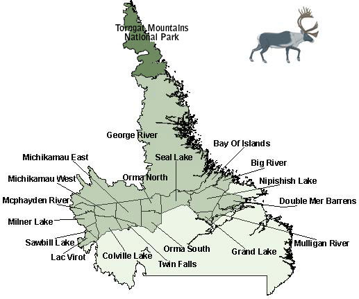
Select one of the zone names on the map to view its boundary description and a map of the zone in PDF format, or choose from the list below.
Areas with fixed dates are subject to immediate closure dependent on the presence of protected woodland caribou.
Click the links under Current Status to access Public Advisories, or visit Department of Environment and Climate Change news releases. In the event of a discrepancy between the chart below and any Public Advisory listed on the department news releases, the Public Advisory takes precedence.
Note: all links below are PDFs and will open in a new window.
| Zone | Season Dates | Current Status | Zone | Season Dates | Current Status |
|---|---|---|---|---|---|
| Bay of Islands(2.0 MB) | N/A | Closed | Michikamau West(1.2 MB) | N/A | Closed |
| Big River(1.3 MB) | N/A | Closed | Milner Lake(1.3 MB) | N/A | Closed |
| Colville Lake(1.6 MB) | N/A | Closed | Mulligan River(1.3 MB) | N/A | Closed |
| Double Mer (1.3 MB) | N/A | Closed | Nipishish Lake(1.8 MB) | N/A | Closed |
| George River(2.6 MB) | N/A | Closed | Orma North( 1.1 MB) | N/A | Closed |
| Grand Lake(855 KB) | N/A | Closed | Orma South(1.5 MB) | N/A | Closed |
| Lac Virot (1.3 MB) | N/A | Closed | Sawbill Lake(1.1 MB) | N/A | Closed |
| McPhayden River(1.6 MB) | N/A | Closed | Seal Lake(1.5 MB) | N/A | Closed |
| Twin Falls(1.4 MB) | N/A | Closed |
Adobe® Acrobat® Reader software can be used for viewing PDF documents. Download Acrobat® Reader for free.