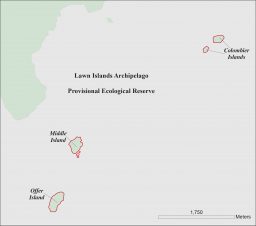
Hunting is prohibited in Salmonier Nature Park, Pippy Park and all Provincial Parks throughout the province, with the exception of waterway Provincial Parks. Hunting is prohibited in National Parks, except as permitted by specific regulations or Land Claims Agreement. Hunting is prohibited in Migratory Bird Sanctuaries and Seabird Ecological Reserves with the exception of Lawn Islands Archipelago Provisional Ecological Reserve (migratory game bird hunting only). Unless otherwise indicated, all big game hunting on the Island of Newfoundland and all moose hunting in Labrador is prohibited on offshore islands.
Special Notice
There are special conditions for the T’Railway Provincial Park; Hunting and trapping are both prohibited inside the boundary of T ’Railway Provincial Park (this is generally defined as 25 feet from each side of the centerline of the rail-bed in most areas). Hunting, trapping and snaring is prohibited inside the boundary of the T’Railway Provincial Park. Hunters and trappers may transport firearms under the authority of a valid hunting licence along the T’Railway Provincial Park, however, it is unlawful to discharge a firearm or set traps inside the Park boundary.
Hunting is permitted within the Main River Waterway Provincial Park in accordance with permits and licenses issued under the Wild Life Act or the Migratory Birds Convention Act, 1994 (Canada) or regulations made under these acts.
Please contact Provincial Parks for more information at 709.637.2040 or info@parksnl.ca or visit www.parksnl.ca
There are some Ecological and Wilderness Reserves which do not have prohibitions on hunting. These include Watts Point Ecological Reserve, Table Point Ecological Reserve, Redfir Lake-Kapitagas Channel Ecological Reserve, West Brook Ecological Reserve, Little Grand Lake Provisional Ecological Reserve, Bay du Nord Wilderness Reserve and the Avalon Wilderness Reserve. A person who holds a valid big game licence for a moose, caribou or black bear management area that is inside a Wilderness Reserve does not require a Wilderness Reserve Entry Permit. Within Mistaken Point Ecological Reserve, a permit is required to access the Fossil Protection Zone. For more information, contact the Natural Areas Program at (Tel) 709.637.4066 or naturalareas@gov.nl.ca or visit https://www.gov.nl.ca/eccm/natural-areas/
The following areas are also subject to hunting, shooting, snaring and/or trapping prohibitions (see maps for further details):
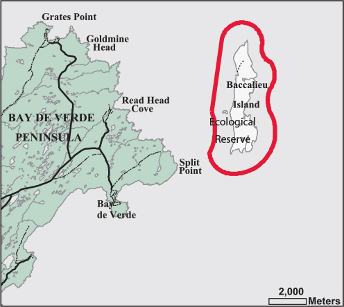
- Baccalieu Island Ecological Reserve (Map 1)
- Closed to Shooting, Snaring and Trapping
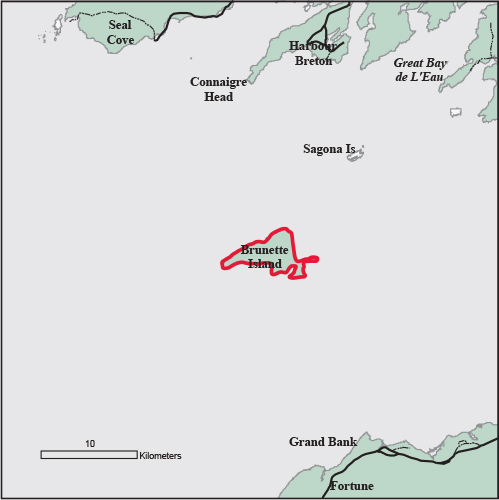
- Brunette Island, Fortune Bay (Map 2)
- Closed to Shooting, Snaring and Trapping
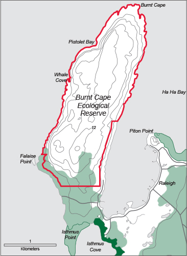
- Burnt Cape Ecological Reserve (Map 3)
- Closed to Shooting (except sea ducks
and murres), Snaring and Trapping
- Closed to Shooting (except sea ducks
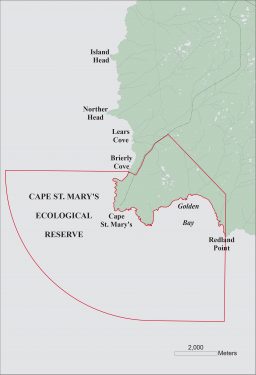
- Cape St. Mary’s Ecological Reserve (Map 10)
- Closed to Shooting, Snaring and Trapping
- Carmanville Pond Closed Area (Map 17)
- Closed to Shooting
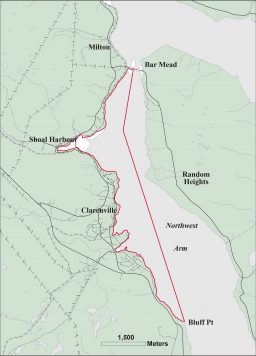
- Clarenville Canada Goose Area (Map 13)
- Closed to Shooting
- Codroy Valley Waterfowl Area (Map 26)
- Closed to Shooting
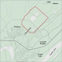
- Corduroy Brook, Grand Falls-Windsor Closed Area (Map 27)
- Closed to Shooting
- Cormack Closed Area
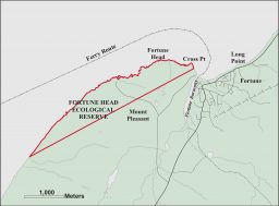
- Fortune Head Ecological Reserve (Map 21)
- Closed to Shooting, Snaring and Trapping
- Foxtrap Closed Area (Map 24)
- Closed to Shooting
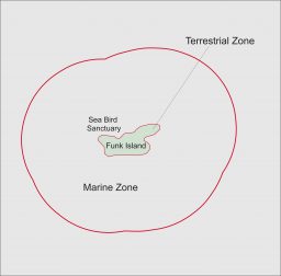
- Funk Island Ecological Reserve (Map 4)
- Closed to Shooting, Snaring and Trapping
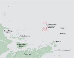
- Gannet Islands Ecological Reserve (Map 5)
- Closed to Shooting, Snaring and Trapping
- Glover Island Public Reserve (see page 41)
- Closed to all small game snaring. Trapping conditions apply, see Best Management Practices for Newfoundland Marten
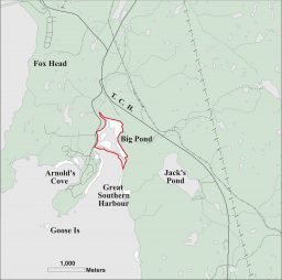
- Great Southern Harbour Closed Area (Map 6)
- Closed to Shooting, Snaring and Trapping
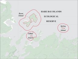
- Hare Bay Islands Ecological Reserve (Map 7)
- Closed to Shooting, Snaring and Trapping
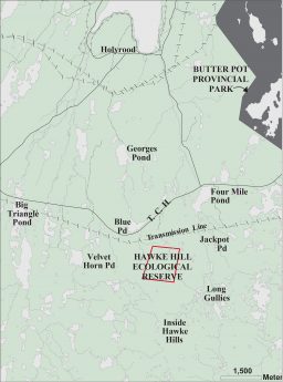
- Hawke Hill Ecological Reserve (Map 8)
- Closed to Shooting, Snaring and Trapping
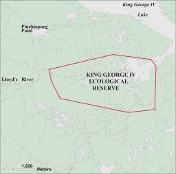
- King George IV Ecological Reserve (Map 9)
- Closed to Shooting, Snaring and Trapping
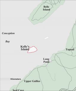
- Kelly’s Island, Conception Bay (Map 25)
- Closed to Shooting and Snaring
- Lawn Islands Archipelago Provisional Ecological Reserve (Map 11)
- Closed to Shooting (except migratory
game birds), Snaring and Trapping
- Closed to Shooting (except migratory
- Little Grand Lake Wildlife Reserve (see page 41)
- Closed to all small game snaring. Trapping conditions apply, see Best Management Practices for Newfoundland Marten
- Main River Study Area (see page 41)
- Closed to all small game snaring. Trapping conditions apply, see Best Management Practices for Newfoundland Marten
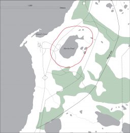
- Marshy Pond, Daniel’s Harbour Closed Area (Map 16)
- Closed to Shooting
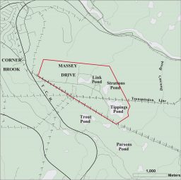
- Massey Drive Local Development Area (Map 20)
- Closed to Shooting
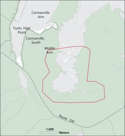
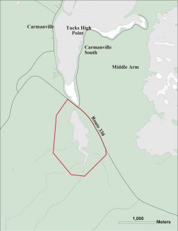
- Middle Arm, Carmanville Closed Area (Map 14)
- Closed to Shooting
- Pine Marten Study Area (see page 41)
- Closed to all small game snaring. Trapping conditions apply, see Best Management Practices for Newfoundland Marten
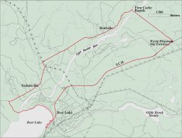
- Reidville-Deer Lake Closed Area (Map 15)
- Closed to Shooting
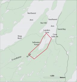
- Saltwater Pond, Sweet Bay Closed Area (Map 19)
- Closed to Shooting
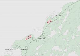
- Sandy Cove Ecological Reserve (Map 22)
- Closed to Shooting, Snaring and Trapping
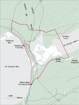
- St. George’s River, Stephenville Crossing Closed Area (Map 18)
- Closed to Shooting
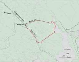
- Winterland EcoMuseum (Map 23)
- Closed to Shooting
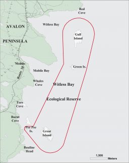
- Witless Bay Ecological Reserve (Map 12)
- Closed to Shooting, Snaring and Trapping