

- How to get There
- Activities
- Maps
- Services
- Fees and Schedules
- Rules and Regulations
- Permits
- Other Resources
- Contact Information
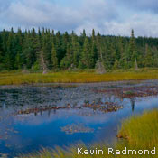
The Avalon Wilderness Reserve protects 1,070 km2 of barrens and forests, and habitat for the Avalon Woodland Caribou herd, the most southerly caribou herd in Canada.
In addition to the caribou herd, you might also encounter Moose, Willow Ptarmigan (known locally as ‘partridge’), and in the rivers, Brook and Brown Trout, Smelt, and landlocked salmon. Six scheduled salmon rivers have part or all of their drainage systems in the reserve-the Renews, Biscay Bay, Peter’s, North Arm and Salmonier Rivers, and Northwest Brook.
Users of the reserve should be prepared for a wilderness experience. There are no facilities, amenities, trail markers, or public buildings within its borders. Mobile phone service is spotty, though it is sometimes possible to get service from hilltops in the reserve. A gravel road network and a series of hydroelectric dams and dykes belonging to Newfoundland Light and Power predate reserve establishment.
This wilderness environment with its landscape of barrens, ponds, rivers, bogs, small forests, and thickets makes the Avalon Wilderness Reserve an excellent place for hiking, canoeing, skiing, angling, hunting, bird and wildlife watching, photography, and wilderness camping. The reserve protects a representative portion of the Maritime Barrens-Southeastern Barrens subregion (1.1 MB)
Use the following guidelines when preparing for your visit:
- obtain an entry permit
- let someone know your route and expected time of return
- travel light and leave no trace of your passage
- carefully plan your clothing, footwear, and equipment
- take a compass and appropriate 1:50,000 topographic maps
- read and abide by the rules and regulations
One of the oldest protected areas in the province, this reserve was established as the Avalon Wilderness Area in 1964 under the Wildlife Act, and designated a Wilderness Reserve in 1986 under the Wilderness and Ecological Reserves Act.
How to get there
The Avalon Wilderness Reserve is located in the centre of the eastern half of the Avalon Peninsula, on the Island of Newfoundland. Its northern border is about 50 km south of St. John’s. An entry permit is required to visit the Avalon Wilderness Reserve.
Two unpaved roads (owned and maintained by Newfoundland Light and Power) give access to the eastern side of the reserve from Route 10. (Note: these roads are suitable for four-wheel drive vehicles with high clearance only.)
- The Cape Pond Road leaves Route 10 across from Rowsells Hill, near La Manche Provincial Park. It gives access to Cape Pond after about an hour drive, and is a good choice for canoeists. However, with high water in early spring, this road can be impassable.
- Horse Chops Road leaves Route 10 just north of Cape Broyle, and goes 26.5 km into the reserve. This route leads to the southern end of Stage Pond, a four hour drive from Cape Broyle and gives access to several canoe routes. The road forks to the right after Fly Pond. This route leads to Franks Pond, a three hour, 7.5 km, drive from Cape Broyle. With high water in early spring, roads can be impassable in places.
Hikers can access the area via several paths: the D’Iberville Trail, Riverhead Trail, Biscay Bay Trail and Daniel’s Point to Holyrood Pond Trail. These are described under Activities.
Canoeists can paddle into the reserve from locations on Peak Pond Road, off the Salmonier Line/Route 90 (consult your topographical map).
Float plane and helicopter access is possible, but you must have an entry permit from the Natural Areas Program, Land Management Division. To arrange this, contact the Division. While over the reserve, aircraft must not be flown at altitudes lower than 300 metres, except during landing and take-off.
Note that snowmobiles and off-road vehicles including ATVs are not permitted in the reserve.
Contact Natural Areas staff to request a copy of the User’s Guide which contains a map outlining access routes and trails.
Activities
The Avalon Wilderness Reserve is an excellent place for outdoor recreational activities including the following:
- Hiking
- Canoeing
- Skiing
- Wilderness Camping
- Bird and Wildlife Watching
- Photography
- Hunting
- Angling
Entry permits are required and should be carried while you are in the reserve.
Hiking
There are four hiking trails in the reserve. Directions given below describe the most-used route. For more information, please refer to a topographical map for the area.
Due to difficulties posed by high water levels, hiking is not recommended in the early spring.
Riverhead Trail
- Access – from Route 90, 9 km north of Riverhead, 9 km southeast of St. Joseph’s
- Length – about 5 km
- Notes – the path heads east from the highway, passing south of Gull Pond and into the caribou herd’s calving grounds. It crosses barrens and bogs, winds through forest, and crosses some small brooks. Keep to your right at the major fork in the trail south of South Gull Pond. Waterproof footwear is advisable.
 D’Iberville Trail
- Access – from Route 90, near the northwest bank of the Salmonier River, on the edge of St. Catherines
- Length – 55 km
- Notes – this primitive wilderness trail commemorates the first military crossing of the interior of the southwestern Avalon by French Navy Captain Pierre LeMoyne d’Iberville in 1696. Travelling from the west, as d’Iberville and company did, you head southeast, after crossing the Salmonier River. There is no bridge and water levels vary-so care is needed to ford the river. The trail passes through the northeastern part of the reserve, and ends in Ferryland on the Avalon Peninsula’s east coast.
Biscay Bay Trail
- Access – from Route 10, about 10 km west of Portugal Cove South, near the Coast Guard tower
- Length – 13 km
- Notes – the trail follows the Biscay Bay River (a scheduled salmon river) into the reserve and is popular with salmon anglers. Leave the communications tower road and head toward Follies Pond, through an area known as the Backwaters. After entering the reserve, follow the Biscay Bay River north to Cooks Pond, near Stockes Pond. Waterproof footwear is a must.
Daniel’s Point to Holyrood Pond Trail
- Access – Daniel’s Point is 5 km west of Trepassey on Route 10, the trail begins at Northwest Brook
- Length – 24 km
- Notes – this former cart trail follows Northwest Brook into the southwest corner of the reserve. It will take you up Grinders Hill, where there is a spectacular view of the surrounding area. You enter the reserve after you pass Mount Misery Pond. It takes about six hours to reach the Peter’s River valley-an excellent place to spend the night. The trail leads through bog, marsh, rivers, tuckamore, barrens, and forests, and ends at an access road about 5 km north of St. Mary’s on Route 90.
Canoeing
The 40-km Avalon Wilderness Reserve canoe route provides a three- to five-day journey through the reserve. It is advisable to begin at Cape Pond (see How to get there) and end at Peak Pond, to the northwest, which allows you to travel with the flow of the water.
The canoe route is mostly on ponds, and has several portages over barrens and through forests. The canoeing requires intermediate skills. There are few opportunities for river running; most rapids offer a challenge only when there’s high water, which occurs in the early spring. It is advisable to check water levels before starting a trip by contacting the Reserve Manager.
The route provides excellent opportunities to view wildlife in its native habitats, as it passes almost entirely through the designated protected area.
Wilderness Camping
Potential wilderness campsites exist throughout the Avalon Wilderness Reserve-at pond or forest edge and along the rivers. Many of these have excellent swimming opportunities. Anyone entering the reserve for a wilderness camping experience must obtain an entry permit.
To limit the footprint you leave behind, campers are asked to stay in one location no more than 10 days. Please do not litter, and pack out everything you bring in, including cans, glass, and other refuse. In some seasons, open fires are not permitted. Contact the local office of the Department of Natural Resources to determine if open fires are permitted.
Note that off-road vehicles, including snowmobiles and ATVs, are not permitted in the reserve.
Bird and Wildlife Watching
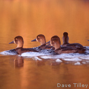
Binoculars are an excellent addition to the pack when travelling in the Avalon Wilderness Reserve. Birdwatchers will easily spot Canada geese, northern harrier, common snipe, loon, and belted kingfisher in the reserve. In addition to the geese, common waterfowl include black duck, northern pintail, green-winged teal, ring-necked duck, and common golden eye.
On land, you can catch sight of willow ptarmigan, red crossbill, yellow warbler, savannah sparrow, dark-eyed junco, northern waterthrush, and pine grosbeak. You may also observe bald eagle, rough-legged hawk, sharp-shinned hawk, goshawk, and merlin.
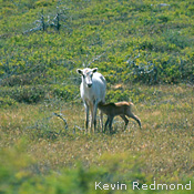
It is always thrilling to catch sight of caribou, which in summer may be spotted grazing on the barrens or even swimming across ponds. Adult females can weight up to 135 kg, males can reach 270 kg; both genders can have antlers. Males in the Avalon herd are known to grow larger than average racks, but the percentage of females in this herd that grow antlers is lower than average.
In the summer, the caribou prefer the barren, open areas of the reserve, eating a variety of lichen and green plants. Traditionally most of the Avalon herd spends the summer near Peter’s River. In late August and early September, they migrate northward to the rutting grounds, then to the wintering grounds to the southwest. The calving grounds are mainly in the northwestern portion of the reserve-females migrate there in the spring to give birth.
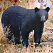
Moose-an introduced species on the Island of Newfoundland-are also plentiful in the Avalon Wilderness Reserve. Other mammals found in the area include lynx, fox, snowshoe hare, otter, beaver, coyote, muskrat, weasel, mink, red squirrel, shrew, and meadow vole.
Hunting and Trapping
Hunting large and small game is allowed in the reserve. Residents and non-residents of the province can participate in this activity if they hold a valid entry permit and hunting licence-which must be carried while in the reserve-abide by provincial and federal legislation, and only hunt species for which an open season has been declared. As of 2004, Caribou Management Area 65 (Avalon Peninsula) is closed to hunting. Please consult the annual Hunting and Trapping Guide for updates.
In addition to an entry permit, registered trappers must also have a valid trapping licence and can trap a variety of mammals in the reserve, including beaver, lynx, mink, muskrat, otter, red squirrel, fox, and weasel.
Note that the use of ATVs for game retrieval is not allowed in the reserve. Snowmobiling is also prohibited.
Angling
The six scheduled salmon rivers that have all or part of their drainage systems in the reserve are:
- Renews River
- Biscay Bay River
- Peter’s River
- Northwest Brook
- Salmonier River
- North Arm River
In addition to salmon, these and eight other rivers support runs of seagoing brown trout, smelt, and brook trout.
In addition to an entry permit, residents must have a valid salmon licence, available at many local sport shops and convenience stores.
In addition to an entry permit, non-residents of the province require a licence to fish in any inland waters; they must also be accompanied by a licensed guide when fishing for salmon. For a list of guides, visit the Government of Newfoundland and Labrador Hunting and Fishing Site.
All provincial and federal regulations apply when fishing in the reserve. For information on general regulations pertaining to salmon and trout angling in inland coastal waters of Newfoundland and Labrador, please consult the annual Newfoundland and Labrador Angling Guide, published by Fisheries and Oceans Canada. If further clarification is required, please contact Department of Fisheries and Oceans, local provincial Forestry/Wildlife offices, or provincial Government Services Centres.
Note that snowmobiles and off-road vehicles including ATVs are not permitted in the reserve.
Services
There are no services within the reserve so it is important to use these guidelines when preparing for your visit:
- Obtain an entry permit
- Let someone know your route and expected time of return
- Travel light and leave no trace of your passage
- Carefully plan your clothing, footwear, and equipment
- Take a compass and appropriate 1:50,000 topographic maps
- Read and abide by the rules and regulations
Note that if you take a cell-phone, coverage will be spotty-though it is possible to make calls from some hilltops.
Fees and Schedule
The reserve is open all year round. However, certain activities will be greatly influenced by the season and weather conditions.
Permits are required for various activities, but no fees are charged.
Rules and Regulations
Wilderness conservation is one of the province’s reserve system’s primary goals, so there are rules governing activities within all of our wilderness and ecological reserves. Some rules are universal, some vary with each reserve.
All wilderness reserves are open to a range of low-impact recreational activities-entry permits are required.
The following activities are strictly prohibited in all wilderness and ecological reserves:
- Disturbing, destroying, or removing plants, animals, or fossils
- Introducing plants, animals, or anything else to the reserve landscape
- Forestry, mining (including exploration), hydro development, agriculture, new roads, tracks, or buildings
- Driving off-road vehicles including all-terrain vehicles (ATVs)
In the Avalon Wilderness Reserve, the following regulations also apply:
- Entry permit is required. You must carry your entry permit (and other applicable permits) with you while in the reserve.
- Snowmobiles and ATVs are not permitted in the reserve. The use of ATVs for game retrieval is also not permitted.
- Camping in one location is restricted to a maximum of 10 days.
- Pack out everything you bring in, including cans, glass, and other refuse.
- Keep dogs and horses under control at all times when in the reserve.
- Outboard motors are restricted to Cape, Mount Carmel, Franks , Bloody, Blackwood, and Southwest Ponds or other ponds accessible by road, and must not exceed 6 hp.
- Float plane and helicopter access is permitted with a valid entry permit. While over the reserve, aircraft must not be flown at altitudes below 300 metres, except during take-off and landing.
- During some seasons, open fires may be prohibited. Contact your local office of the Department of Natural Resources to determine if open fires are permitted. Completely extinguish fires before leaving.
Read the official reserve regulations:
- Wilderness Reserve Regulations
- Avalon Wilderness Reserve Order
- Wilderness and Ecological Reserves Act
Adobe® Acrobat® Reader software can be used for viewing PDF documents. Download Acrobat® Reader for free