

Due to the volume and frequent updating of the water level and other data made available on this web site this data is considered to be PROVISIONAL because it has not undergone quality control checks. These data may be subject to significant change.
Since the early 1900’s, communities, including Deer Lake and Steady Brook, have developed along the Humber River. Every year some flooding occurs along the Humber River, while usually minor, the potential for significant flooding exists, as occurred in 1969 and 1981.
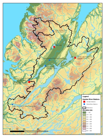
The Division monitors a series of hydrometric, climate and snow monitoring stations in the Humber River Basin and uses the information collected for flood forecasting which is described in further detail below.
Background
The Humber River is located on the western side of the island portion of Newfoundland and Labrador. It has a reach of 153 km, originating in Gros Morne National Park and draining into the Bay of Islands.
Measured at the Humber Village hydrometric station, the drainage area of the river is 7,860 km2, it is the second largest basin on the island. There are two main braches of the Humber River; Upper Humber has a drainage area of 2,110 km2 and Grand Lake, which is regulated to produce hydroelectricity at Deer Lake, has a drainage area over 5,000 km2.
Flood Risk Mapping
Flood risk mapping studies for the communities of Deer Lake and Steady Brook were carried out under the Canada-Newfoundland Flood Damage Reduction Program. These studies analyzed causes of previous floods, defined flood events a return period of 20 years (5% chance in any year) and 100 years (1% chance in any year), considered remedial measures, and produced flood risk mapping. The Deer Lake and Steady Brook studies, listed below, are available online in electronic format.
- Hydrotechnical Study of the Deer Lake Area (1987)
- Hydrotechnical Study of the Steady Brook Area (1984)
- Study of Possible Remedial Measures for the Steady Brook Area (1986)
Based on the studies, the flood risk maps show flood risk zones for floods with a return period of 20 years and 100 years. The maps are used for public information, municipal planning, development control, and the setting of structural design criteria. All proposed developments in flood risk zones are evaluated against potential impacts on water resources, on the developments themselves, and on the surrounding areas. The public information maps for Deer Lake and Steady Brook are available in electronic format through the links below.
Public Information Map for Deer Lake Area
SmallLargePDF
Public Information Map for Steady Brook Area
SmallLargePDF
River Monitoring and Flood Forecasting
Generally, flooding along the Humber River is a result of the combined effects of precipitation and snowmelt, occurring during the spring-runoff period. The Water Resources Management Division (WRMD) operates a flood forecasting service during the period. When a flood forecast is greater than the defined flood event, there is a potential for flooding. When the potential for flooding exists, the WRMD informs Emergency Services Division-Newfoundland and Labrador and the communities of Deer Lake and Steady Brook for appropriate action. Currently, the WRMD operates two flood forecasting models, a dynamic regression (DR) model and a neural network (NN) model.
For the last number of years, the Humber River flood forecasting model operated by the WRMD was the DR model. The DR model, which was developed in-house, uses a number of observed hydrometric and weather parameters to stochastically forecast river flows for up to three days. In 2009, the NN model was developed for the WRMD. The model does not require any forecast weather parameters and accounts for snowmelt through the degree-day parameter. The NN model is capable of forecasting one-day flow.
Both the DR and the NN models have divided the Humber River into three reaches coincident with the hydrometric stations: the Upper Humber Above Black Brook, Upper Humber Near Reidville, and Humber River At Humber Village Bridge. Documentation outlining the DR and NN flood forecasting models is available, in electronic format, through the links below.
- A Comparative Study of Flow Forecasting in the Humber River Basin using a Deterministic Hydrologic Model and a Dynamic Regression Statistical Model (4.6 MB)
- Flood Forecasting on the Humber River using an Artificial Neural Network Approach (644 KB)
Snow reports are developed by the WRMD to quantify the extent of snow cover and the amount of water, stored as snow, in the Humber River basin. Leading up to, and during, the spring-runoff period, these reports are updated regularly in order to quantify potential runoff due to snowmelt, as it will contribute to the potential for flooding.
As part of the data collection network, that is critical for the operation of the flood forecasting service, the WRMD maintains a webcam and a climate station at Humber Village Bridge and monitors hydrometric stations along the Humber River. Data from these stations, plus other stations, in the basin are shown below.
Due to the volume and frequent updating of the water level and other data made available on this web site this data is considered to be PROVISIONAL because it has not undergone quality control checks. These data may be subject to significant change.
Humber River Stations
| Station Name | Location | ADRS | EC |
|---|---|---|---|
| Upper Humber River above Black Brook | 74 km – Upstream of Humber Village Bridge | 02YL008 | EC |
| Upper Humber River Above Black Brook – Weather Station | This is a snow monitoring and climate station that is used to measure runoff from the Upper Humber Basin | NLENCL0007 | |
| Adies Lake | 20 km – Away from Upper Humber River near Reidville | ADIES | |
| Upper Humber River near Reidville | 45 km – Upstream of Humber Village Bridge | 02YL001 | EC |
Humber River at Nicholsville Bridge  |
37 km – Upstream of Humber Village Bridge | NLENHM0004 | |
| Sandy Lake near Birchy Narrows (Camp 55) |
This is a snow monitoring and climate station that is used to measure runoff to Sandy Lake which flows into Grand Lake. | NLENCL0005 | |
| Grand Lake east of Grand Lake Brook | Grand Lake is regulated by a Dam which flows into the Humber River at Deer Lake | 02YK010 | EC |
| Deer Lake near Generating Station | 33 km – Upstream of Humber Village Bridge | 02YL007 | EC |
| Humber River at Humber Village Bridge | 0 km – Humber Village Bridge | 02YL003 | EC |
| Humber River at Humber Village Bridge Weather Station |
0 km – Humber Village Bridge | NLENCL0003 | |
| Steady Brook 470 meters above Confluence to Humber River |
6.5 km – Downstream of Humber Village Bridge | 02YL012 | EC |
| Definitions | Description |
| A Webcam is installed at this site. | |
| ADRS | This link displays the web page for this station which includes graphs of all data and downloadable csv files. Due to the volume and frequent updating of the data the streamflow, water quality and climate data shown is PROVISIONAL and has not undergone quality control checks. These data may be subject to significant change. |
| EC | This link is to the Environment Canada, Water Survey of Canada web page for this station. Provisional Stage-Flow data and Stage-Flow data that has gone through a comprehensive QA/QC procedure are available. There are also links to historical publication quality Stage-Flow data and summaries for each station. |
Adobe Acrobat® Reader software can be used for viewing PDF documents. Download Acrobat® Reader for free.