| SPECIES | Fur Zones 1-10 | Fur Zone 11 |
| Beaver | Oct 20/19 – April 15/20 | Oct 20/19 – Apr 15/20 |
| Muskrat | Nov 1/19 – Mar 15/20 | Oct 20/19 – Mar 15/20 |
| Otter | Nov 1/19 – Mar 15/20 | Oct 20/19 – Mar 15/20 |
| Mink | Nov 1/19 – Feb 28/20 | Nov 1/19 – Feb 28/20 |
| Coyote | Nov 1/19 – Feb 1/20 | Oct 20/19 – Feb 1/20 |
| Fox, Coloured | Nov 1/19 – Feb 1/20 | Oct 20/19 – Feb 1/20 |
| Fox, White | Nov 1/19 – Feb 1/20 | Oct 20/19 – Feb 1/20 |
| Lynx | Zone A-Jan 1/20–Feb 1/20
Zone B- Jan 15/20–Feb 1/20 |
|
| Wolf | Nov 1/19 – Feb 1/20 | Oct 20/19 – Feb 1/20 |
| Ermine (weasel) | Nov 1/19 – Feb 28/20 | Oct 20/19 – Feb 28/20 |
| Squirrel | Nov 1/19 – Feb 28/20 | Oct 20/19 – Feb 28/20 |
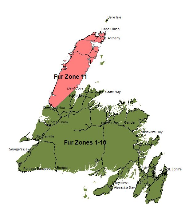
| SPECIES | Fur Zone 11 |
| Lynx | All that area of the Island of Newfoundland bounded by a line beginning at the confluence of South East Arm Brook and Bonne Bay Southeast Arm at UTM coordinates 21 U 448689.53 meters E 5478547.24 meters N; then following the northern shoreline of Bonne Bay Pond toward the west coast of the Northern Peninsula; then following a general northerly direction along the western shoreline of the Great Northern Peninsula to Cape Onion; then following a generally southerly direction along the eastern shoreline of the Great Northern Peninsula to the confluence of Devil’s Cove with Cat Arm River at UTM coordinates 21 U 516940meters E 5541470meters N; then following a straight line in a generally south westerly direction to the point of commencement. |
*Trappers who hold a valid trapping licence may also shoot lynx, fox and coyote using rifles up to .225 calibre during the trapping seasons for these species.
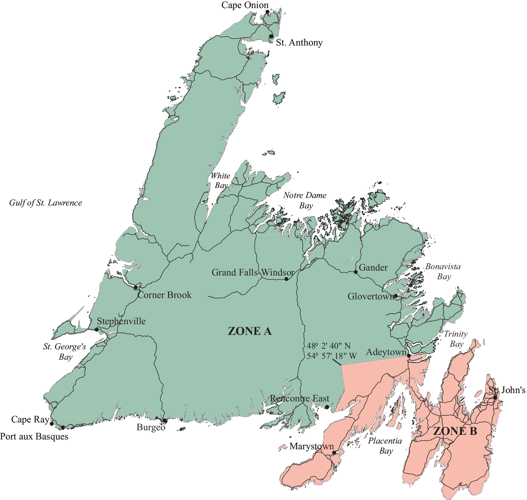
Lynx Zone A: Northern Region
All that area of the Island of Newfoundland bounded by a line beginning at the intersection of the Burgeo highway with the southern coastline of Newfoundland; then following said coastline in a generally westerly direction to Cape Ray; then following the coastline in a generally northwesterly, then northeasterly direction to Cape Onion; then following the coastline in a generally southwesterly direction to the confluence of Hampden River with White Bay; then following the northeastern coastline of Newfoundland in a generally northeasterly, then easterly, then southeasterly direction to Adeytown; then following a straight line in a generally southwesterly direction to a point at 48° 2’ 40” North latitude and 54° 57’ 18” West longitude; then following a straight line in a generally southeasterly direction to the northernmost point of Long Harbour; then following the western shoreline of Long Harbour in a generally southwesterly direction to its intersection with the Newfoundland coastline; then following said coastline in a generally westerly direction to the point of commencement; including all external islands except Belle Island, Brunette Island, Bird Island, and Duck Island.
Lynx Zone B: Southern Region
All that area of the Island of Newfoundland bounded by a line beginning at the intersection of the Burgeo Highway and the south bank of Llyods River; Then following a straight line in an easterly direction to the southern extremity of Mollyguajeck Lake where a small stream enters the lake; Then following the southern shoreline of Mollyguajeck Lake to Terra Nova River; Then following the southern bank of the Terra Nova River to Terra Nova Lake; Then following the southern shoreline of Terra Nova Lake to its eastern most extremity where it Terra Nova River; Then following the southern bank of the Terra Nova River to its outflow located at Glovertown South; Then following the coastline of insular Newfoundland including all offshore islands and excluding all areas within National Park jurisdiction in southerly direction to the northern extent of the intersection of the coastline of Insular Newfoundland and the causeway to Grandy Island; Then following the Burgeo Highway in a northerly direction to the point of commencement.