

Prospecting in Newfoundland…
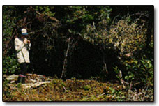
Prospecting – for most people the word conjures up an image of an oldtimer panning for gold along a northern river. Prospectors did look like that in the old days, but today prospectors are also construction workers, stock brokers, mechanics, fishermen, woods workers, housewives, geologists etc. – anyone who enjoys the outdoors and is interested in the natural environment.
Newfoundland has had a long history of mineral production which began in the 1800’s. The copper industry in the Notre Dame Bay area, which made Newfoundland the sixth largest copper producer in the world, for a time in the late 1800’s, was established by prospectors. The Tilt Cove Mine was found by a fisherman who was using heavy boulders (massive copper ore) for ballast in his boat. The Betts Cove, Little Bay and Pilley’s Island Mines in Notre Dame Bay and the Terra Nova Mine in Baie Verte were also discovered during this period.
The Buchans Mine was found by a Micmac trapper – Matty Mitchell, who was prospecting in the area north and west of Red Indian Lake. Gold and copper deposits in the Baie Verte area, including the Rambler, were found by prospectors such as Enos England, in the early 1900’s and the Baie Verte asbestos deposit was found by prospector Norm Peters in the 1950’s. The Bell Island iron mines were discovered when someone recognized that heavy boulders used for ballast in ships from the area were iron ore. All of these properties were sold or optioned by the prospectors to mining interests.
Prospecting for gold in Newfoundland and Labrador appears to have been limited to a period between the late 1800’s and 1940, but began again in the early 1980’s due to increases in the gold price. A geological map of the Baie Verte area, produced in 1983, shows only 2 or 3 gold occurrences, including the Goldenville deposit, near Ming’s Bight, which was found in the late 1800’s and a couple of small quartz veins containing gold on the Rambler property. Today, there are at least 100 known gold occurrences, one of which, Pine Cove near Ming’s Bight, is now a producing gold mine. Two other gold occurrences in the Baie Verte Peninsula, Nugget Pond near Snook’s Arm and Hammerdown near King’s Point, also produced gold from 1997 to 1999 and between 2001 and 2004, respectively.
Prospectors associated with mining companies discovered most of these prospects, however there are still significant deposits to be found throughout Newfoundland and Labrador by individuals. For example, two occurrences of white quartz with visible gold were found by geologists working for International Corona Corporation in October 1990 on the Pine Cove Property near Ming’s Bight. The town of Baie Verte, across the Bay, can be seen from the occurrences which are exposed on the side of small bogs approximately 250 m apart and inland about 500 m from the Bay. These occurrences were unknown until this time – it is obvious that no one had ever thoroughly prospected this area and other areas of the province are the same.
Only two significant gold showings have been found in Labrador, to date; the Aucoin Showing in North Central, and the VBE-2 showing just south of Voisey’s Bay Ni-Cu-Co Mine. A study of the geology of Canada indicates that the Canadian Shield is one of the most prolific gold hosts in the world. A significant portion of Labrador is part of the Canadian Shield and geological intuition tells us that we should expect Labrador to host significant gold deposits. Where are they? Prospecting should be able to help us find these deposits. Who can do this better than the people in the area who know the country and who have seen something in the rocks that arouses their curiousity, but do not know what it is.
Where to Look
Prospecting requires a keen eye for subtle differences in the rock, either the color or general appearance, and an idea of what might be found in an area. Geological maps, available from the Department of Mines and Energy, can give the prospector an idea where the best locations for prospecting might be. For example – minerals are often hosted in certain rock types; faults, or breaks in the earth’s surface, allow fluids from deep in the earth which carry dissolved metals including gold, silver and base metals to rise to the surface and alter the rocks. The changes in temperature and pressure of the fluids at the surface, allow the contained metals to be precipitated (deposited) in these altered rocks.
Panning of streams is an excellent way to quickly evaluate areas. Gold, base metal sulphides, diamonds, and some other minerals are heavy (gold is 20 times heavier than water), and accumulate in the sand and gravel beds in the rivers. Panning of samples from these locations can quickly and cheaply evaluate the area through which the river passes. In most cases the heavy minerals, particularly gold, can be seen in the pan giving a visual signal of mineralization. The prospector continues up the stream until no more mineralization is seen in the pan. He then goes back downstream to the nearest tributaries and pans them to try to locate the source stream. He continues up the tributary showing signs of mineralization, which should get stronger (more mineralization) as the source is approached. Prospecting in the area defined should result in location of the mineralization in outcrop or as boulders.
Clean rock exposures are usually plentiful along stream/river valleys and can be readily examined. Boulders which have been carried downstream from areas drained by the stream are also found and can be prospected for mineralization.
What to Look For
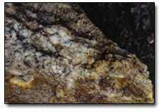
Gold may occur as visible specks or nuggets in quartz veins. It can also occur in sulphides – pyrite (fools gold) where it would probably not be visible and would require an assay or analysis to determine its presence.
Gold and other elements are often associated with alteration, which is a process that rocks undergo when they are changed by hot fluids from deep in the earth. The presence of alteration may be signaled by a change in rock color (i.e. from red to green or brown and then back to red again) over a short distance. The rock often becomes much harder, due to the addition of silica from the fluids and the altered zone often carries quartz and associated sulphides (such as pyrite or fools gold).
Sulphides oxidize or “rust” on the surface. Rusty zones then provide a clue to the presence of sulphides which may carry base metals or gold or both. Gold may be visible, as small specks, in these zones (such as many on the Baie Verte peninsula) or an assay or analysis may be required to detect the presence of base metals and/or gold. Oxidation or staining on the rocks suggests the presence of other elements such as copper (green, blue colors), nickel (green), cobalt (purple), and molybdenite or uranium (yellow). Most sulphides have a metallic lustre (i.e. look like metal) and can be identified by their crystal structure and color.
What You Need
All that is required for a prospecting trip is a hammer, packsack and an interest in the outdoors. Prospector’s hammers are hard to obtain in Newfoundland (there are one or two local sources) but brick hammers are usually available at most hardware stores and work well. A gold pan is optional but useful. Maps, a compass, safety supplies, including safety glasses, and outdoor (all-weather) gear should be carried at all times. Yearly, two week long, prospecting courses, are held in Stephenville and Happy Valley-Goose Bay each June and July. A total of approximately 26 positions are available each year. There is a cost for this course and an application has to be made to the department of Energy and Mines. Information on prospecting, the prospecting course or the mineral potential of Newfoundland and Labrador can be obtained by contacting:
Mineral Exploration Consultant
Prospecting is a great hobby, for anyone who appreciates the outdoors and can be done by people of all ages and both genders. It will probably not make you rich, but it is a good way to keep fit and enjoy the beautiful scenery of our province.
By Peter M. Dimmell, P. Geo.