

Date: January 4, 2004
Location: Curling
Easting: 429400
Northing: 5422800
Latitude: 48° 57′ 30″ N
Longitude: 57° 58′ 10″ W
Fatalities: 0
Injuries: 0
Source: CBC web site.
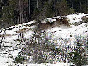
A landslide/ rockfall occurred in the Corner Brook – Curling area. There appeared to be no obvious ran-fall event associated with the slope movement. Reports from the CBC web site are given below.
Landslide closed Corner Brook arterial
Jan 5 2004
CORNER BROOK – It could be several days before one of the main transportation arteries in Corner Brook is open to traffic again.
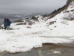
A section of the Lewin Parkway in the Curling area was closed early Sunday morning after a landslide sent tonnes of rock and debris onto the road.
The Department of Works, Services and Transportation says engineers are at the site Monday to assess the situation.
A spokesperson says they want to make sure the hillside is safe before they start removing debris from the road.
The cause of the landslide hasn’t been determined. Traffic has been diverted around the site.
Jan 6 2004
CORNER BROOK – It could be another week before an arterial road road in Corner Brook reopens to traffic. A landslide early Sunday morning blocked a section of the Lewin Parkway overlooking Curling.
The Department of Works, Services and Transportation says as much as 3,000 tonnes of rock tumbled onto the road.
The blocked road
Regional engineer Don Matthews says removing the debris from the parkway and on the hill above it will take time.
“We have to try and make sure of what we find and get it stabilized to address the safety issue,” he says. “We don’t want to just clear away a road and find more material coming down on it.”
Matthews says he hopes the site assessment will be finished Tuesday so that the job of trucking debris from the area can start Wednesday.
Photos copyright CBC