

Date: September 27, 2005
Location: Riverside Drive, Corner Brook
Easting: 434395
Northing: 5422881
Latitude: 48° 57′ 35″ N
Longitude: 57° 53′ 40″ W
Fatalities: 0
Injuries: 0
Source: Western Star September 29 2005, VOCM web site
Heavy rainfall caused widespread damage in west coast communities, including Corner Brook, Stephenville, Reidville and Deer Lake. Over 110 mm of rain fell in a brief period.
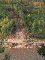
In Corner Brook, about 65 m of Riverside Drive was damaged, following the failure of a berm, and landsliding. The road was blocked by landslide debris in places.
The berm was constructed in 1994 after a similar landslide occurred. It was designed to direct flow of water away from the unstable slope. The berm gave way in heavy rainfall, and the resulting water flow triggered a landslide. This debris torrent incorporated soil, vegetation and moving down-slope broke power and waterlines. The landslide destroyed the guardrail and crossed the road, terminating in the Humber River. Water continued to flow down the landslide scar, washing down more material. the road was covered by debris over approximately 30 metres.
The broken power lines took two hours to restore, and about 20 homes lost water.