Date: 1823
Location: Ferryland, Dead Man’s Gulch
Easting: 358550
Northing: 5209200
Latitude: 47° 02′ 00″ N
Longitude: 52° 53′ 00″ W
Fatalities: 42
Injuries: 0
Source: Newfoundland Quarterly, March 1902, Ferryland (what doth not appear in history) John W White,
White writes:
“On the southwest of the narrows of Ferryland there’s a deep gulch in the side of the cliff. The casual observer can see nothing extraordinary in this, and therefore does not make any inquiries. Nethertheless there’s a sad story connected with it. It is called by every fisherman “Dead Man’s Gulch” and its history may be told in a few words. As it now appears it shows as if a semi-circular piece were cut out of the cliff extending from its top, inclusive, to its bottom to about two to three feet from the surface of the sea at high tide. In 1823 or thereabouts it did not thus appear. It was then a mammoth cave, with an entrance to the ocean, in and out from which fishermen were accustomed to go from time to time to secure bait fish that used to frequent the gulch. But in the year of which I write forty-two fishermen in about 14-15 boats entered the cave to avoid being swamped by a severe storm of wind and rain, accompanied by the usual heavy sea which had overtaken them while on the fishing ground. They ran as far as the cave, and there all took shelter. They waited for hours but still the storm abated not. As it grew late peals of heavy thunder could distinctly be heard but no-one ever knew how these poor creatures listened and heard with fear and trembling. No one from shore could attempt a rescue; and even if they could, it is doubtful if they would, as no safer place than the cave could be thought of as long as their food held out. But in the night the watchers on shore heard a louder peal of thunder than any previous one, and nearer, and then all was quiet. The distant rumbling previously heard still periodically went on, but there was nothing heard similar to the very loud and near one which had frightened them all so much. When daylight came the wind had died away and several set out to see how their friends in the cave had fared during the night. They arrived at the Gulch (as gulch it was then) and discovered that during the night its roof had fallen in, burying the 42 fishermen – not one having been rescued. None of the bodies were ever picked up; having been buried, no doubt, beneath the crushing mass of stone which had fallen on them. This had been the loud peal of thunder heard by the people during the night. The present floor or landing place of the Gulch was formerly the top of the cave’s roof. The Gulch, itself, is tenanted by saltwater pigeons, hundreds of them having nests in cliffs on the side of the Gulch.”
White tells the story in considerable detail but does not indicate the source of this information. Corroboration of the story has proved difficult – few newspapers were published in this period, and those that were published have much of 1823 missing in the archived copies.
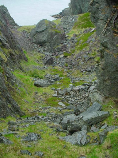
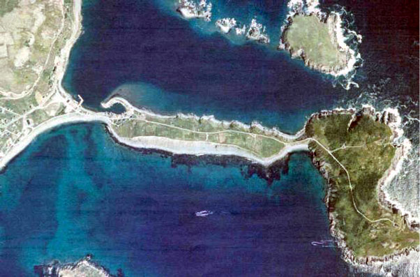
White describes the events at “Deadman’s Gulch”, a feature now clearly apparent on aerial photographs as a gulch or notch in the cliff edge, extending several hundred metres inland from the coast on the south side of the Narrows that lead into Ferryland Harbour.
If this story is authentic, this is the worst geologically related disaster in the Province of Newfoundland (with 14 more deaths than the Burin Peninsula tsunami), and the third worst landslide disaster in Canadian history (Evans 1999), with more people being killed only in the Frank slide (75 fatalities in 1903) and in Quebec City (50 killed in 1889).
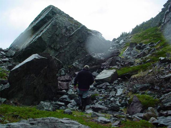
The site was visited in the summer of 2002. It is apparent that a major rockfall has occurred at this location. The mouth of the gulch is choked with large, angular boulders ranging from 1 to 7 m in diameter. The bedrock in this area consists mainly of sandstone of the Ferryland Head formation (King 1988), dipping to the east at 75°. The Gulch appears to have formed when wave action exploited a more easily erodible bed, forming a sea cave extending back from the coast over 100 m. The current floor of the Gulch contains a well grassed area on the surface of which well rounded erratic boulders are found. These boulders are not found elsewhere in the gulch. This may be the upper roof of the cave, preserved after collapse. Thus there is sound geological evidence of a major cave collapse and rockfall in the gulch that lends some credence to White’s account.