
- How to get there
- Activities
- Maps
- Services
- Fees & Schedules
- Rules & Regulations
- Other Resources
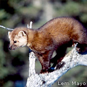
One of the last wilderness rivers-and one of the best white-water canoeing rivers-on the Island of Newfoundland, the Main River may be memorable for the thrilling ride it gives, but it offers much more than rapids and paddling excitement. Virgin boreal forest, placid lakes, the slow waters and lush surroundings of the Big Steady-Atlantic salmon and abundant wildlife – habitat for the endangered Newfoundland marten – spectacular viewscapes and a true wilderness passage-all these are part of the Main River experience.
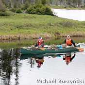
The Main River is renowned as a wilderness adventure waterway for experienced canoeists. Highly suitable for white-water canoeing, kayaking, and rafting – not to mention angling and bird- and wildlife watching – it has its headwaters in the Long Range Mountains, passes through the tranquility of the Big Steady, and runs its last 23 km in a white-water dash to the sea.
The Main is at the base of the Great Northern Peninsula. From its headwaters, 675 metres above sea level, you can see the barrens and tundra of the Long Range Mountains behind Gros Morne National Park. The river heads away from these through old-growth forests, flowing 57 km in a southeastern direction to the salt waters of White Bay, emerging near the community of Sop’s Arm. For a description of the five sections (or “Units”) of the Main, see Canoeing.
One of the jewels of the Main River experience is “the Big Steady,” about 17 km from the headwaters, where the river snakes and slows, flowing through flat grassland. Islands on the Big Steady are open and park-like; two-century-old birch and spruce – ancient enough to have trunks that reach 75 cm in width – flank the area’s streams and pools.
The Main River passes through terrain that is home to 70 species of bird, caribou from the Northern Peninsula herd, many kinds of waterfowl, as well as moose, black bear, and the endangered Newfoundland marten. Atlantic salmon and brook trout swim in its waters. Its unique ecosystems belong to two of the province’s ecoregions – the Long Range Barrens (Northern Long Range subregion) (783 KB) and the Northern Peninsula Forest (Eastern Long Range subregion) (887 KB). Many of the plants that grow there are at the extent of their northern or southern ranges.
Though it’s known for its summer water activities, the area is also an excellent venue for wilderness recreation in winter. Appropriate snow conditions persist for much longer than elsewhere on the Island, often from January right through to May.
Three archaeological sites have been identified along the river. Evidence of early Inuit habitation dates to about 2,100 years ago. Along the north side of the river, just west of Sop’s Arm, remains of nomadic Beothuk culture have been found. In more recent centuries, the French and the English had fishing enterprises in the area.
First nominated as a Canadian Heritage River in 1991, the Main received its designation in February, 2001. It is managed by the Parks Division and comprises the river corridor, which will be a 152-km2 Waterway Provincial Park, and a surrounding Special Management Area of 49 km2 within the river’s 1,048-km2 watershed area.
Adobe® Acrobat® Reader software can be used for viewing PDF documents. Download Acrobat® Reader for free.