
Archaeology in Newfoundland and Labrador 1996
Edited by K. Nelmes
The Russell’s Point Beothuk Site, Trinity Bay, Newfoundland
William Gilbert
The Russell’s Point site was discovered in 1988 by William Gilbert and Ken Reynolds during an archaeological survey conducted to locate a Beothuk camp visited by John Guy on 26 October, 1612 and described by him in his journal (Gilbert and Reynolds 1989).
In October of 1612 John Guy and 18 others set sail from Cupids on a voyage of discovery into Trinity Bay. The main purpose of this voyage was to meet and establish friendly relations with the Beothuk. Guy and his party sailed into an arm at the bottom of Trinity Bay which Guy called Savage Harbour where they found several Beothuk structures and a trail leading into the woods. Following the trail, they came to what Guy described as “a great fresh water lake” about a mile from the salt water. On the shores of this lake they found a Beothuk camp consisting of three houses. The Indians had taken shelter on an island in the lake. However, the colonists spent some time examining the camp and both Guy and Henry Crout, another of the colonists, wrote detailed descriptions of it (Gilbert 1990:151-154).
A careful analysis of the documents related to the voyage indicates that Guy’s Savage Harbour is present day Dildo Arm and that the fresh water lake is Dildo Pond, a 5 km (3 mile) long lake located roughly 1.6 km (1 mile) south of the bottom of Dildo Arm in the community of Blaketown (ibid. 151-154). A thorough survey of Dildo Pond produced evidence of a Beothuk presence at only one location: Russell’s Point (Figure 1). Test pits dug there produced numerous fire cracked rocks, flakes, calcined bone and a small corner notched projectile point typical of the early historic Beothuk (Gilbert and Reynolds 1989:7).

Excavations have been ongoing at the site for three years and seem to confirm earlier speculations that it is the camp described by Guy. The point encompasses an area of roughly 1200 square metres and cultural material is distributed over most of it. To date a total of 136 one metre units have been excavated at the site and approximately 1500 artifacts have been recovered (Figure 2). The vast majority of these are stone tools including 350 projectile points and projectile point fragments. Most of these points are small with minimal retouch and either straight or slightly expanding stems and can be assigned, using the chronology developed by Schwarz, to the early historic period (Schwarz 1984:61-62). However, some, including an unusual side notched example, suggest an earlier Recent Indian presence at the site. A number of items of European manufacture have also been recovered including wrought iron nails, an iron key, an iron knife, copper fragments, fragments of case bottle glass and a fragment of coarse red earthenware. Eighteen hearths have also been uncovered at the site (Gilbert 1995, 1996a).

Historical Background
There are few 16th century documents that refer to the Beothuk and those that do are often so vague as to provide little information of any real value. Indeed, in a number of cases the geographic and ethnographic details in these documents are so confusing that some may actually refer to other northeastern hunter/gatherer groups (Pastore 1992:48-49). The majority of documents on which our knowledge of the Beothuk is based date to the late 18th and early 19th centuries (Howley 1915:27-127) and describe the Beothuk living in Notre Dame Bay and the Exploits Valley region. These documents tell of a people who were under increasing pressure from European settlement and whose traditional way of life had been greatly disrupted.
A notable exception to this are a number of documents written during the second and third decades of the 17th century. Practically all that we know about the Beothuk during this period comes from documents related to either the Cupids colony and attempts by the planters there to establish a trade with the Beothuk, or from the writings of Richard Whitbourne, and all describe the Beothuk living in Trinity Bay (Howley 1915, Quinn 1979, Cell 1980, Gilbert 1990 & 1992). These documents provide us with an invaluable source of information on the Island’s aboriginal people during this early period. John Guy and Henry Crout’s descriptions of the camp at the bottom of Trinity Bay are the oldest detailed descriptions of a Beothuk camp in existence. The next known description of such a camp was written by John Cartwright during his expedition up the Exploits River in 1768 (Howley 1915:29-45), 156 years later. Similarly, Guy and Crout’s descriptions of Beothuk clothing, material culture and way of life provide invaluable data for archaeologists and ethnohistorians.
Despite this, the study of the Beothuk presence in Trinity Bay is still in its infancy. Certain historians have even suggested that 17th century Beothuk seldom ventured south of Cape Bonavista and that Guy’s encounter with the Beothuk was a lucky accident with the colonists from Cupids happening across a group of Beothuk who had somehow strayed south of their usual haunts (Rowe 1977:16-17). We now know that this is not the case. Rather, Guy’s voyage into Trinity Bay was the result of extensive reconnaissance and there was a substantial Beothuk presence in Trinity Bay in the fall of 1612 (Gilbert 1990, 1992).
It has long been believed that Beothuk-European contact was minimal and consisted mainly of the Beothuk pilfering from fishermen and occasional violent reprisals by fishermen against the Beothuk. An analysis of the relevant documents suggests that a different situation may have existed in Trinity Bay during this early period. Although there is some evidence of conflict, the Beothuk in Trinity Bay, while cautious, appear to have been less hostile and more inclined to trade with Europeans (Cell 1969:68; Gilbert 1992:7-8). We now have two documented incidents of trade between Beothuk and colonists at the bottom of Trinity Bay (one in 1612 and the other in 1613), and there is some evidence to suggest that at least a marginal trade was taking place as late as 1620. A number of letters written in Cupids by Thomas Rowley during 1619 and 1620 make references to the Beothuk at the bottom of Trinity Bay. In one, dated 13 September, 1619, he states that he and a Master Hill are leaving “to go in the bottome of trinity bay about 16 dayes henc[e]” with knives to trade with the Indians. Another letter written during the winter of 1620 contains a list of supplies which includes “leads hachets looking glasses be[a]ds a drum: [and] shomakers thrid” all to be used as “Truck for savages” (Gilbert 1992:6-7).
Relationship to Previous Archaeological Work
The vast majority of Beothuk sites, as opposed to earlier Recent Indian sites, found to date are located in central Newfoundland along the Exploits River and Red Indian Lake and date to the late 18th and early 19th centuries. Unfortunately many of these sites were dug by amateur archaeologist Don Locke under less than ideal conditions (Locke n.d.a, n.d.b, 1975). In the Exploits River/Red Indian Lake region only Wigwam Brook (LeBlanc 1973) and portions of Indian Point (Devereux 1970, Sproull Thomson 1981) have been professionally excavated. Scientific excavations have also been conducted at Boyd’s Cove and Inspector Island both on the eastern side of Notre Dame Bay (Pastore 1982, 1983, 1984, 1985, 1992), and at the Beaches in Bonavista Bay (Devereux 1969, and McLean 1991, 1994).
Wigwam Brook was a late historic site; Indian Point contained both a late historic and a prehistoric component; Boyd’s Cove appears to have been occupied from roughly 1650 to 1720, and Inspector Island had both a prehistoric and early historic component. The period of occupation for the Beaches has been harder to determine. However, it appears to have been utilized over a long period and may have been occupied as late as the early 18th century (Laurie McLean, personal commmunication).
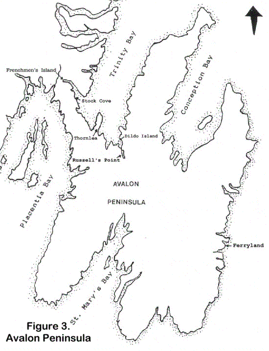
Work conducted at Frenchmen’s Island (Evans 1981, 1982) and Stock Cove (Robbins 1985) provided the first archaeological evidence to support the Beothuk occupation of Trinity Bay attested to by Guy, Crout, Whitbourne and others (Figure 3). Interestingly, both these locations were mentioned by Guy. At Stock Cove, Guy reported seeing “nine savage houssen used by them in their coasting” (Gilbert 1990:157) and he chose Frenchmen’s Island as the location for his abortive trading post because, he said, “For any bartering with the savages theare cannot be a fitter place” (ibid.:159).
Robbins’ work at Stock Cove concentrated on the large Dorset component at that site. However, the amount of Indian material recovered led him to conclude that the site might also represent “one of the larger Recent Indian occupations on the Island” (Robbins 1985: 51-52). The presence of European material in association with some of the Indian material seemed to indicate that part of this occupation took place during the historic period (ibid.:161).
Frenchmen’s Island contained Dorset Eskimo, Recent Indian and mid-17th century European components (Evans 1980:88-94; 1981:210-225). Some of the initial radiocarbon dates from this site were obviously inaccurate, placing the Little Passage material in the first millennium AD (Evans 1981:216). An analysis of the Recent Indian material from Frenchmen’s Island by Schwarz suggested an occupation extending from the 8th century AD to the 16th century AD (Schwarz 1985:41-41, 64).
Two other Recent Indian sites have been discovered in the bottom of Trinity Bay over the past few years: Thornlea 1 (CjAk-2) and Dildo Island (CjAj-2). No excavations have been conducted at either of these sites to date. However, Thornlea appears to correspond to a deserted camp visited by Henry Crout on 2 November 1612 (Rutherford and Gilbert 1992:26); while the site on Dildo island may be the one reported by Crout on 11 July, 1613 (Gilbert 1996b:15). Testing at the latter has revealed both prehistoric and early historic material (ibid.:15-17).
Recent work by James Tuck at Ferryland has shown that the Beothuk range extended as far east as the Southern Shore of the Avalon Peninsula during the 16th century. Excavations there have revealed hearths containing European ceramics, flakes and Beothuk stone tools well below the level of the later 17th century occupation. The absence of clay pipe fragments from this deposit has led Tuck to conclude that these deposits probably date to sometime before 1580 (Tuck 1993:299).
The Questions
Russell’s Point has the potential to enhance our knowledge of both the Beothuk presence in Trinity Bay and Beothuk culture in general during the early historic period. The material from Russell’s Point can be utilized in an effort to answer the following questions (Though I will not attempt to answer these questions definitively here, I will attempt to show how they can be answered):
- How long was Russell’s Point utilized by the Beothuk and what does this tell us about the Beothuk occupation of Trinity Bay?
- What role did Russell’s Point play in the seasonal round of the Trinity Bay Beothuk and what does this tell us about Beothuk seasonality during the early historic period?
- What evidence is there for Beothuk-European trade or other forms of contact at Russell’s Point and to what extent, if any, had Beothuk culture in early 17th century Trinity Bay been affected by contact with Europeans?
- Is there any evidence to suggest a connection between the Beothuk at Russell’s Point and the Beothuk component at Ferryland?
- What can the features uncovered at Russell’s Point tell us about the Beothuk utilization of the site and of Beothuk culture in general?
- What if anything can Russell’s Point tell us about plant use by the early historic Beothuk?
1. Period of Occupation.
We know that there was a substantial Beothuk presence in the bottom of Trinity Bay during the second decade of the 17th century (Gilbert 1990, 1992). However, the question of when Recent Indian people first arrived in this part of the island remains unanswered. Had the bay long been part of their territorial range or was their arrival in the area a recent occurrence perhaps predating Guy’s voyage by only a few years?
Evidence recovered from some of the sites mentioned above seems to suggest the former. The discovery of prehistoric Recent Indian material at both Frenchmen’s Island (Evans 1981:221-223) and Dildo Island (Gilbert 1996b:10-11, 15-16) indicates an older Indian presence in the region, while the discovery of early 16th century Beothuk material at Ferryland shows clearly that the Beothuk had extended their range well east of Trinity Bay by that time.
As mentioned above, a total of eighteen hearths have been located at Russell’s Point. These hearths seem to have survived because they were excavated into the underlying beach gravel. The amount of hearth debris scattered over the site suggests that there were many other hearths whose existence has been either obscured or almost totally obliterated by later activity. Applying Chatters’ concept of “feature discreteness” (1987:346) to Russell’s Point it seems obvious that the site was reoccupied on numerous occasions over a fairly long period of time. However, just how long a period of time is a question that remains to be answered.
There are several ways in which data from Russell’s Point might help to clarify this question. One is artifact typology: Over the past twelve years our understanding of stylistic changes in Recent Indian tool manufacture has greatly improved. While there are some gaps in our knowledge, and certain categories are still quite broad, this developing typology does allow us to arrange artifacts, especially projectile points, in a rough chronological sequence (Schwarz 1984). Three hundred and fifty projectile points and projectile point fragments have been recovered from Russell’s Point to date. This represents one of the largest collections of Recent Indian/Baothuk projectile points yet to be recovered. A detailed analysis of these, along the lines pioneered by Schwarz, should allow us to establish a basic chronology for the site.
Another tool that may help us answer this question is radiocarbon dating. A number of the hearths excavated at Russell’s Point have yielded charcoal samples. Radiocarbon dating of these samples may provide us with a rough time frame for the occupation of the site. Indeed, the combination of artifact analysis and radiocarbon dating may help us to better refine our artifact typology.
Some of the European material recovered from Russell’s Point may also help us to date the occupation of the site. While much of this material, such as wrought iron nails, are notoriously difficult to date, a few artifacts including a key, an iron knife and a fragment of course red earthenware may provide some clues as to the site’s chronology.
Considering the broader picture of the Beothuk occupation of Trinity Bay, comparisons could be made between the Russell’s Point collection and material from Stock Cove and Frenchmen’s Island. Robbin’s work at Stock Cove focused on the Dorset occupation of that site and a detailed analysis of the Frenchmen’s Island excavation has yet to be published. By comparing these three collections we may be able to draw some important conclusions about the Recent Indian/Beothuk occupation of Trinity Bay. For example, were all three sites occupied during the same period or is the material from some of the sites older than that from some others and what does this tell us about the movement of Recent Indian/Beothuk people over time?
2. Seasonality
Documentary and archaeological evidence indicate that for much of the historic period the Beothuk pursued a seasonal round divided between spring and summer exploitation of marine resources on the coast and fall and winter exploitation of caribou and other terrestrial resources in deep interior locations such as the Exploits River and Red Indian Lake (Howley 1915, Devereux 1970, LeBlanc 1973). However, recently some scholars have suggested that the situation may have been quite different for the Beothuk and their Little Passage ancestors during the late prehistoric and protohistoric periods (Rowley-Conwy 1990, Schwarz 1992, 1994). Rowley-Conwy has hypothesized an “ideal winter base camp” for this period located “on rivers or ponds offering easy access by canoe or ice travel both to the interior and the coast” and suggested that such camps were utilized by the Beothuk until the development of winter transhumance by European settlers created competition for the resources of the near coastal zone and forced the Beothuk deeper into the interior (Rowley-Conwy 1990: 26). Following Rowley-Conwy, Schwarz has argued, based largely on evidence recovered from Gambo Pond, that during the late prehistoric period such near-coastal settlement “was not a sporadic occurrence, but rather, was firmly integrated into a marine-terrestrial subsistence-settlement system” of Recent Indian people” (1992:55).
If Rowley-Conwy and Schwarz are correct, it is possible that Russell’s Point is one such winter base camp. Located only 1.5 miles from the coast, the site offers easy access to the marine resources at the bottom of Trinity Bay, while access to the resources of the interior of the Avalon is facilitated by a series of streams and small ponds. The early date of the site also suggests that it was part of a seasonal round that had not yet been affected by the pressures of European settlement. Analysis of the data from Russell’s Point could allow us to test this hypothesis.
The documents mentioned above can help us to partially address the question of seasonality at Russell’s Point. We know from Guy’s journal that the site was occupied on October 26, 1612 and his description seems to indicate that the Beothuk there were involved in hunting caribou. Guy reports that “this time of the yeare they live by hunting, for we fownd twelve stages hoofes that weare latelie killed.” He also mentions that two of the three houses located on Dildo Pond were covered “with deere skinnes” (Cell 1982: 71). Interestingly, when Guy met a group of Beothuk two weeks later in Bull Arm they were transporting “deeres flesh dryed in the smoake, or wind” (ibid.: 74). We know too that the site was unoccupied in July of the following year. On 11 July 1613 Henry Crout returned to Dildo Arm “Only to see,” he said, “[if they] wear still [inhabiting] in the freshe watter lake w[hi]ch we did see last year.” They were not, and Crout stated that this was because they were “gone all abroad acoasting… for Eeggs and birds agaynst the wyntter” (Gilbert 1992:4-6). Still, the question remains whether Russell’s Point was a temporary fall hunting camp, possibly intended to intercept the Bay de Verde caribou herd as it migrated south towards its wintering grounds around St. Mary’s Bay, or a long term winter camp.
Perhaps the best way of addressing the question of seasonality at Russell’s Point is through the study of faunal remains. Unfortunately, the soil at the site is extremely acid and bone preservation is poor. However, several hundred fragments of calcined bone have been recovered from hearth features and an analysis of this material should allow us to better understand how the site fits into the seasonal round of the early historic Beothuk population of Trinity Bay.
While faunal remains probably represent our best means of addressing the question of seasonality, site features may also help us to answer this question. If Russell’s Point were used for only a short time during the fall one would expect to find fairly insubstantial features. However, if the site served as a winter base camp, this should present itself in the archaeological record in terms of more substantial remains including middens and perhaps house pits.
To date no evidence of either middens or house pits have been found at Russell’s Point and this may indicate that the site was a temporary, special purpose camp. However, the absence of house pits may not necessarily rule out winter occupation. It is possible either that the Trinity Bay Beothuk did not use pit houses or that pit houses were not adopted until later in the historic period. If faunal analysis does indicate a winter occupation at this site, this would help to strengthen this hypothesis.
Another clue to seasonality may be found in the relative frequency of artifact types at the site. Based largely on his work at Gambo Pond, Schwarz (1992:58-62) has suggested that one of the indicators of fall and/or winter occupation at near-coastal Recent Indian sites might be a relatively high proportion of scrapers to projectile points. Since fall is the prime time for preparing caribou hides, and winter the prime time for most other hides, it would seem logical that fall and winter would be the period during which scrapers were most highly utilized. Schwarz argues that scrapers may be viewed as semi-expedient tools that are quickly exhausted and usually discarded at the site of use. By contrast, according to Schwarz, projectile points “are the most extensively finished tool type found” (ibid.:61) and would have a much higher level of curation.
During the 1994 and 1995 seasons, 201 projectile points and projectile point fragments and 118 scrapers and scraper fragments were recovered from Russell’s Point. The ratio of projectile points to scrapers is 63.01% to 36.99%. If Schwarz’s hypothesis is correct, this suggests that Russell’s Point was a specialized hunting camp rather than a long term fall and winter camp. An analysis of artifact frequency at Russell’s Point coupled with faunal analysis could help to test the validity of Schwarz’s hypothesis.
Here too, a comparison between the Russell’s Point collection and the Stock Cove and Frenchmen’s Island collections could prove extremely helpful. There can be little doubt that the people who utilized Russell’s Point and those who utilized Stock Cove and Frenchmen’s Island were one and the same. Most likely each site represents a different aspect of the seasonal round of the Trinity Bay Beothuk. Schwarz has suggested that Frenchmen’s Island was a coastal base camp providing easy access to the resources of both the coast and the interior and that Stock Cove was a “special exploitation camp” possibly used to hunt non-migratory seal species (Schwarz 1985:41-42, 64). An analysis of all three of these collections including the relative frequency of artifact types at each site could help to clarify our understanding of how each fit into the seasonal round of the Trinity Bay Beothuk.
3. European-Beothuk Contact
The Beothuk have long been perceived as something of an anomaly in the history of European-Aboriginal relations in North America and are generally depicted as having avoided contact with the Europeans who first fished off of, and later settled the Island of Newfoundland (Rowe 1977). As mentioned above, however, the situation in Trinity Bay during the early 17th century appears to have been different. Not only did the Beothuk encountered by John Guy and Henry Crout exhibit a willingness to trade but they seem to have been more familiar with the nuances of trade than were the colonists themselves (Cell 1969:68; Gilbert 1990:159-165 & 1992:7-10).
Certainly Guy’s encounter with the Beothuk on 5 November 1612 can in no way be viewed as an instance of ‘first contact.’ Both Guy and Crout make it quite clear that the people they met in Trinity Bay had access to a variety of European goods and list among other things found at the Indian camps at the bottom of the bay: copper kettles, Basque oars, a sail, fish hooks, a fishing line and a lead, a caulking iron and a fisherman’s cape (Cell 1982:70-74; Gilbert 1990:154-161). Crout states that the Beothuk were conducting a trade with the French (Gilbert 1992:10), while David Kirke reports that they were trading with both the French and the Basques (Kirke 1871:134) and there seems to be little reason to doubt this. However, the exact nature of this contact and to what degree it had altered the material culture of the Trinity Bay Beothuk remains unknown.
Since we know that Russell’s Point was occupied during this period, the site provides us with an invaluable opportunity to study the question of early 17th century contact. A certain amount of European material has been recovered from the site and an analysis of this material may allow us to better understand the nature of Beothuk/European relations at this time. If we can determine the source of any of the European material recovered from the site, we will have a better idea of with whom the Beothuk had contact. In addition, the nature of the European material recovered will allow us to better understand the extent to which the Beothuk had adopted European technology.
The question of whether the European material recovered at Russell’s Point was acquired as a result of trade, pilfering or some combination of the two is a difficult one. There is little that has been recovered that can irrefutably be linked with either direct trade or dumb barter. Yet the presence of items such as an iron knife and fragments of case bottle glass do at least hint at the possibility of trade. We know of two instances, one in 1612 and the other in 1613, when knives were given to the Beothuk at the bottom of Trinity Bay in exchange for furs (Gilbert 1990:158-159; 1992:6-7), and Thomas Rowley’s correspondence during 1619 and 1620 indicates that knives were considered an important trade item at that time. The Trinity Bay Beothuk were also given “aquavitie,” a type of distilled liquor, in both 1612 and 1613 and this would most likely have been transported in case bottles (Noel Hume 1969:62).
Perhaps more easily resolved than the nature of Beothuk-European contact at this time is the question of with whom the Beothuk had contact. The place of origin of certain items such as the key, the knife and the ceramic can almost certainly be determined, while metallurgical analysis of the iron and copper may also help to determine the source of these materials.
An examination of the European material at Russell’s Point might also provide us with new insights into the origins of Beothuk iron working. We know that by the time the Beothuk were living at Boyd’s Cove (circa 1650 to 1720) they were altering European iron to produce arrowheads and other tools (Pastore 1992:30-31). Indeed, a developing iron technology can be traced from roughly the mid-17th century through to the late 18th/early 19th century by which time iron had almost totally replaced stone in the manufacture of Beothuk tools (McLean 1990:168-176). When exactly the Beothuk began the practice of altering iron is still unclear. However, a number of wrought iron nails have been recovered from Russell’s Point including one that shows evidence of having been altered. The study of these artifacts could allow us to better understand the early stages of a technology that continued to develop throughout the historic Beothuk period.
4. Links Between Russell’s Point and Ferryland.
The discovery of Beothuk material at Ferryland raises a number of interesting questions, not the least of which is the origin of these aboriginal visitors to the Southern Shore. Could there be a connection between the Beothuk at Russell’s Point and those at Ferryland? Is it possible that the Beothuk living in Trinity Bay were making trips overland to Ferryland to scavenge iron from seasonal fishing stations?
A comparative study of the Beothuk material from these two sites might permit us to answer this question. Such a study would involve three approaches: attribute, petrographic and metallurgical analysis. A comparative attribute analysis of the Russell’s Point artifacts and those from Ferryland may allow us to detect similarities that might suggest some connection between the two groups. Perhaps more telling would be a petrographic analysis of the raw material used at both sites. If the raw material used by the Beothuk at Ferryland is the same as some of the raw material used by the Beothuk at Russell’s Point this would indicate a common source and may also suggest some link between the two. Metallurgical analysis has already been mentioned above. If such analysis reveals similarities between the iron at Ferryland and the iron at Russell’s Point, then an argument could be made for Ferryland being the source of the Russell’s Point iron. On the other hand, analysis may reveal a different source for this material.
5. The Features.
As noted above, eighteen hearths have been uncovered at Russell’s Point. These hearths range in type from linear hearths, the longest measuring 4.90 m, to small elliptical examples measuring as little as 40 cm across. Some of these hearths were well preserved while others were more ephemeral, having been disturbed by later activity. All have been drawn, photographed, profiled and otherwise properly recorded (Gilbert 1995:12-14; 1996a:4-8).
The discovery of these different features at the site poses an interesting question. Do these different features indicate different activities at the site, possibly taking place at different times of the year, or do they represent changes in hearth construction over time? If the former, then the differences may help us to better address the question of seasonality at the site. If the latter, these differences may help us address the question of site chronology.
There are a number of ways of addressing this question. Comparisons could be made between the features found at Russell’s Point and similar features from other sites where seasonality and period of occupation have been firmly established. For example, the linear hearths could be compared to other examples found at places like Boyd’s Cove and Deer Lake Beach (Pastore 1986:218-225; Reader 1994:15-25). Radiocarbon dating may also prove useful. If there is a noticeable difference in dates recovered from different types of hearths, then we may be able to establish a rough chronology for these features. On the other hand, if the differences in hearth design are functional rather than chronological then this should be reflected in the faunal samples from each hearth. If faunal samples from different types of hearths can be assigned to different times of the year, then the argument for seasonal variation in hearth types would be strengthened. Similarly, if different types of animal bones are recovered from different types of hearths, or if the bones have been processed in different ways, then the argument for functional differences in hearth design will be reinforced.
6. Plant Use.
The study of Beothuk palaeoethnobotany has the potential to make a significant contribution to our understanding of plant use by the Beothuk. Since 1990 plant remains from a number of Recent Indian and Beothuk sites have been examined by palaeoethnobotany classes at Memorial University (Deal 1995; Deal & MacLean 1995). Over the past two field seasons a considerable number of soil samples have been collected from the hearths at Russell’s Point. Palaeoethnobotanical analysis of these samples may enrich our understanding of plant use by the Trinity Bay Beothuk.
Further Field Work
During the 1996 season a number of items of European manufacture were found in the extreme southeastern portion of the excavation area. Among these were an iron knife, a fragment of coarse red earthenware, and several wrought iron nails including one modified example. These discoveries suggest that more European material may exist to the southeast of the current excavation.
Since a major part of this project involves the analysis of European material from the site, a further six weeks of excavation is planned for 1997. Work during this period will concentrate on the area southeast of the previous excavation where a further 16 1×1 m units will be excavated. It is hoped that excavation in this area will allow us to recover a larger sample of European material from the site and better address the question of Beothuk-European contact.
References
Carignan, Paul C.
1975 – The Beaches: A Multi-Component Habitation Site in Bonavista Bay. Ottawa: Mercury Series No. 39, National Museum of Man, National Museums of Canada.
1977 – Beothuk Archaeology in Bonavista Bay. Ottawa: Mercury series No. 69, National Museum of Man, National Museums of Canada.
Chatters, James A.
1987 – “Hunter-Gatherer Adaptations and Assemblage Structure.” Journal of Anthropological Archaeology, No. 6:336-375.
Deal, Michael
1995 – “Beothuk Palaeoethnobotanical Research: Current Status and Recommendations.” On file with the Culture and Heritage Division, Department of Tourism, Culture and Recreation, Government of Newfoundland and Labrador, St. John’s, Newfoundland.
Devereaux, Helen
1969 – “Five Archaeological Sites in Newfoundland: A Description.” On file with the Department of Provincial Affairs, Government of Newfoundland and Labrador.
1970 – “A Preliminary Report on the Indian Point Site, Newfoundland: A Stratified Beothuk Site.” On file with the Culture and Heritage Division, Department of Tourism, Culture and Recreation, Government of Newfoundland and Labrador.
Evans, Clifford 0.
1980 – “1980 Field Report of Frenchmen’s Island Project.” In Jane Sproull Thomson and Bernard Ransom, eds., Archaeology in Newfoundland and Labrador, 1980. St. John’s, Historic Resources Division, Dept. of Culture, Recreation and Youth, Government of Newfoundland and Labrador, pp. 83-94.
1981 – “Frenchmen’s Island Site, Preliminary Field Report.” In Jane Sproull Thomson and Callum Thomson, eds., Archaeology in Newfoundland and Labrador, 1981. St. John’s, Historic Resources Division, Dept of Culture, Recreation and Youth, Government of Newfoundland and Labrador, pp. 210-225.
Gilbert, William and Ken Reynolds
1989 – “Report of an Archaeological Survey: Come By Chance River and Dildo Pond.” On file with Culture and Heritage Division, Dept. of Tourism, Culture and Recreation, Government of Newfoundland and Labrador.
Gilbert, William
1990 – “‘Divers Places’: The Beothuk Indians and John Guy’s Voyage into Trinity Bay in 1612.” Newfoundland Studies VI(2), Fall 1990, 147-167.
1992 – “‘Great Good Done’: Beothuk/European Relations in Trinity Bay, 1612 to 1622.” Newfoundland Quarterly LXXXVII(3), Summer/Fall 1992, 2-10.
1995 – “Russell’s Point, 1994: A Report on the Russell’s Point Archaeology Project, July 4 to November 10, 1994.” MS.
1996a – “Baccalieu Trail Archaeology Project, 1995. Phase 2: Russell’s Point.” On file with Culture and Heritage Division, Department of Tourism, Culture and Recreation, Government of Newfoundland and Labrador.
1996b – “Baccalieu Trail Archaeology Project, 1995. Phase 2: Dildo Island.” On file with Culture and Heritage Division, Department of Tourism, Culture and Recreation, Government of Newfoundland and Labrador.
Howley, James P.
1915 – The Beothuks or Red Indians: The Aboriginal Inhabitants of Newfoundland. Cambridge: Cambridge University Press.
Kirke, Henry
1871 – The First English Conquest of Canada: with Some Account of the Earliest Settlements in Nova Scotia and Newfoundland. London: Bemrose and Sons.
LeBlanc, Raymond
1973 – “The Wigwam Brook Site and the Historic Beothuk Indians.” M.A. Thesis, Department of Anthropology, Memorial University of Newfoundland.
Locke, D.
n.d.a – Beothuk Artifacts. Robinson-Blackmore Printers, Grand Falls, Newfoundland.
n.d.b – “Unpublished Field Notes.” On file with Culture and Heritage Division, Department of Tourism, Culture and Recreation, Government of Newfoundland and Labrador.
1975 – “Historic and Prehistoric Sites: Indian Point, Site 1, Wigwam Point, Site 2.” On file at Memorial University, Centre for Newfoundland Studies.
McLean, Laurie
1991 – “Burnside Heritage Archaeology Project: Report for Summer, 1990.” On file with Culture and Heritage Division, Department of Tourism, Culture and Recreation, Government of Newfoundland and Labrador.
1994 – “Burnside Heritage Foundation Archaeology Project: Report for Summer, 1992.” On file with Culture and Heritage Division, Department of Tourism, Culture and Recreation, Government of Newfoundland and Labrador.
Noel Hume, Ivor
1969 – A guide to Artifacts of Colonial America. New York: Alfred A. Knopf.
Pastore, Ralph T.
1983 – “A Preliminary Report on Investigations at Boyd’s Cove-1, A Beothuk and Recent Indian Site in Notre Dame Bay, Nfld.” in Jane Sproull Thomson and Callum Thomson, eds., Archaeology in Newfoundland and Labrador, 1982. St. John’s, Historic Resources Division, Dept. of Culture, Recreation and Youth, Govt. of Newfoundland and Labrador, pp. 133-160.
1984 – “Excavations at Boyd’s Cove, Notre Dame Bay, 1983,” in Jane Sproull Thomson and Callum Thomson, eds., Archaeology in Newfoundland and Labrador, 1983. St. John’s, Historic Resources Division, Dept. of Culture, Recreation and Youth, Govt. of Newfoundland and Labrador, pp.98-125.
1985 – “Excavations at Boyd’s Cove, 1984: A Preliminary Report,” in Jane Sproull Thomson and Callum Thomson, eds., Archaeology in Newfoundland and Labrador, 1984. St. John’s, Historic Resources Division, Dept. of Culture, Recreation and Youth, Govt. of Newfoundland and Labrador, pp. 322-337.
1986 – “Excavations at Boyd’s Cove: The 1985 Field Season, A Preliminary Report,” in Jane Sproull Thomson and Callum Thomson, eds., Archaeology in Newfoundland and Labrador, 1983. St. John’s, Historic Resources Division, Dept. of Culture, Recreation and Youth, Govt. of Newfoundland and Labrador, pp. 218-232.
1992 – Shanawdithit’s People: The Archaeology of the Beothuks. St. John’s: Atlantic Archaeology Ltd.
Reader, David
1994 – “Up the Creek: The Deer Lake Beach Site and Recent Indian Settlement and Subsistance in the Humber Valley Region, Newfoundland.” Vis a Vis: Explorations in Anthropology, Vol 5.
Robbins, Douglas Taylor
1985 – Stock Cove, Trinity Bay: The Dorset Occupation from a South Eastern Perspective. Ph.D. Dissertation, Department of History, Memorial University of Newfoundland.
Rowe, Frederick W.
1977 – Extinction: The Beothuks of Newfoundland. Toronto: McGraw-Hill Ryerson Limited.
Rowley-Conwy, Peter
1990 – “Settlement Patterns of the Beothuk Indians: A View from Away.” Canadian Journal of Archaeology 14: 13-32.
Rutherford, Douglas E. and William Gilbert
1992 – “An Archaeological Reconnaissance of Dildo Arm and Collier Bay, Trinity Bay, Newfoundland.” On file with Culture and Heritage Division, Department of Tourism, Culture and Recreation, Government of Newfoundland and Labrador.
Schwarz, Frederick A.
1994 – “Palaeo-eskimo and Recent Indian Subsistence and Settlement Patterns on the Island of Newfoundland.” Northeast Anthropology, No 47:55-70.
1992 – “Archaeological Investigations in the Newfoundland Interior.” On file with Culture and Heritage Division, Department of Tourism, Culture and Recreation, Government of Newfoundland and Labrador.
1984 – The Little Passage Complex in Newfoundland: A Comparative Study of Assemblages. Ph.D. Dissertation, Department of History, Memorial University of Newfoundland.
Sproull Thomson, Jane
1981 – “Investigations at Red Indian Lake,” in Jane Sproull Thomson and Callum Thomson, eds., Archaeology in Newfoundland and Labrador, 1981. St. John’s: Historic Resources Division, Dept. of Culture Recreation and Youth, Govt. of Newfoundland and Labrador, pp. 174-189.
Tuck, James A.
1993 – “Archaeology at Ferryland, Newfoundland.” Newfoundland Studies 9(2):194-310.