
Ian Badgley
The Block I Project study area is located in the northeastern portion of Mining Licence 932M, on Sachem Bay, about 20 km north-northwest of Nain, Labrador (Figure 1). The archaeological field work carried out in this project was focused, firstly, on the survey of two areas of interest, designated Areas A and B, identified on the basis of geophysical research. Following completion of this work, the greater part of the coastline of the north arm of Sachem Bay was also surveyed.
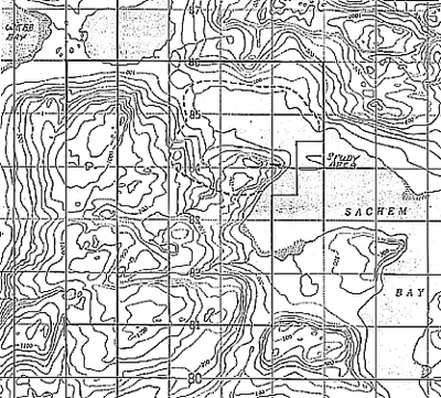
Figure 1: Study Area
Areas Of Interest
Area A is defined by a grid covering 0.45 km2. The baseline, oriented 11 degrees east of true north, is 1100 m in overall length. The northern and southern sections of the grid are 300 m and 600 m in width, respectively.
The Area A grid occupies the western and northwestern flanks of a bedrock hill, extending from a narrow stream valley to the hill summit. The terrain consists of steep slopes, attaining an altitude in excess of 200 m a.s.l. (above sea level). The lower slopes and stream valley are densely forested, while the upper slope and summit are composed of bedrock outcrops interrupted by discontinuous till.
Area B is located on the summit and northern slope of a slightly lower hill situated approximately 500 m west of Area A. Oriented 11 degrees east of true north, this second area measures 450 x 250 m. The Area B terrain also consists of a steep, densely forested slope, with bedrock outcropping in a small clearing at the hill summit.
Survey Results
No historic resources were identified in Area A or B and both areas are considered to be of extremely low or no archaeological potential.
In contrast, nine archaeological sites were recorded along the shoreline of Sachem Bay. Seven of these sites are settlement sites, containing from one to three tent rings and other cultural features (e.g., hearths, a cache pit and fox trap anchors). Site 3 consists of a small inukshuk, composed of a rock perched on a boulder, and Site 5 is defined by an axe-felled tree stump, tentatively interpreted as an anchor post for a fishnet.
Recommendations
Desired drill holes identified by geophysical research are located in the Area A grid, in lines 2000 N, 1900 N, and 1700 N and, results depending, possibly in lines 2100 N and 1600 N. Although no historic resources were observed in this area, it should be noted that archaeological sites 1 and 2 are located at the northern limit of the grid, close to line 2700 N. In order to ensure the protection of these sites, it is recommended that the present Block I Project drill program not extend beyond line 2300 N of the Area A grid. It is also recommended that all work supporting, or in association with this drill program avoid entirely the point on which these two sites are situated.