
Ken Reynolds
Introduction
On August 22nd, 1996 a Stage 1 Historic Resources Impact Assessment of a proposed whale watching site was undertaken in Daniel’s Harbour on the Great Northern Peninsula. This assessment was required by the Culture and Heritage Division (CHD) due to the site’s apparent proximity to the Dorset Eskimo site, Daniel’s Harbour 1 (EbBj-6) (Figure 1). However, the archaeological site is separated from the proposed whale watching building by an approximate 400 metre interval. The project’s infrastructure was to consist of a wooden viewing deck and adjacent parking lot that was to be located near the northern boundaries of the community of Daniel’s Harbour directly off Route 430. This area is used as a turnaround for large trucks and buses; it overlooks Daniel’s Cove where the Palaeo-Eskimo site, Daniel’s Harbour 1, EbBj-6 is located. On first inspection, the land in question appeared to be a man-made terrace; this was borne out by the subsequent assessment. As well as assessing the whale watching site, a walkover of EbBj-6 was also carried out.
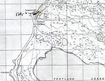
Figure 1. 1:50,000 Scale Topographical Map of Daniel’s Harbour area. X marks approximate location of proposed whale watching site. Dark line represents Thomson’s 1987 survey area.
SITE LOCATION
The terrace, about 12.5 m a.s.l. (above sea level) and approximately 125 m from the salt water, abuts the highway on the Strait of Belle Isle side and is located almost directly across the road from a service station. The crescent-shaped terrace, which is used as a turnaround for large vehicles, measures approximately 50 m on a northeasterly/ southwesterly axis (this measurement was taken at its base near the highway); its width ranged from 17.2 to nearly 21 m. At its northern end a possible man-made bank consisting of fill and rocks runs parallel to the highway. The southern section appears to have been intentionally cut through exposing the fill. This probably occurred some time after the Northern Peninsula highway had been constructed in the late 1960s. Conversely, this could be the remnants of a bank that extended the length of the turnaround area and was bisected to create a level space. However, at the bottom of the terrace dozens of large boulders can be seen. These boulders represent a small number of the probable thousands, along with tons of fill, required to construct the terrace and road bed.
SITE INVESTIGATION
Though it appeared that the area in question was of a recent construction it was decided to test the terrace to be certain. A line of four test excavations was placed near the western edge of the terrace. The first three test excavations were spaced 2.5 m apart while the fourth was placed 5 m away from the third. The terrace’s ground cover consisted of bare gravel nearer to the road and a slight sod cover towards its edge. A brief description of each test pit follows.
TEST PIT #1
Located 3.43 m away from the western edge of the terrace, this test pit was the most northerly. The pit measured 35 x 35 cm and it was excavated to a depth of 39 cm below the sod. It consisted of a fine black silt with a mixture of gravel and small rocks. One recent clear bottle sherd was found at 13 cm below the sod, but was not recovered. Testing of this pit stopped at 39 cm as there was no variation in the stratigraphy.
TEST PIT #2
This test pit was located 2.5 m south of #1 and 3.6 m east of the terrace’s edge. This pit was larger, measuring 56 x 42 cm, and was excavated to a depth of 40 cm. The stratigraphy consisted of a fine beach sand with gravel and medium sized rocks. On average this layer continued to a depth of 20 cm, where it changed to the fine black silt, gravel and rocks; the same as was found in test pit #1. At 40 cm below the sod the test was ended with no change in the stratigraphy. The only object found was a plastic wrapper at 2 cm below the sod; it was not kept.
TEST PIT #3
Test pit #3 was located 2.5 m south of #2 and 3.2 m east of the terrace’s edge. The stratigraphy consisted entirely of sand, gravel and rocks as was found in the first 20 cm of #2. Excavation stopped at 39 cm below sod when no stratigraphic change was encountered. The only cultural material found in this test pit was a plastic salt bag at 33 cm below the sod.
TEST PIT #4
This excavation had to be located 5 m south of #3 because of the dumping of asphalt at the 2.5 m area; it was 2.2 m east of the edge. The stratigraphy consisted of a sand layer 8 cm thick. This was followed by brown silt with gravel and large rocks. This excavation was stopped at 23 cm below sod with no change in the stratigraphy. Plastic was the only object found.
CONCLUSIONS
The four test pits all showed evidence that the terrace had been constructed from various types of fill. The testing, when combined with the visual evidence seen at the base of this terrace, all point to its recent man-made construction. The proposed whale watching site would be located in an area free of historic resources and therefore its construction poses no danger.
Note:
It was later determined that the parcel of land in question was located on the highway reserve, therefore the whale watching site was never constructed.
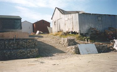
Figure 2. Looking northeasterly towards proposed whale watching site from Daniel’s Cove.
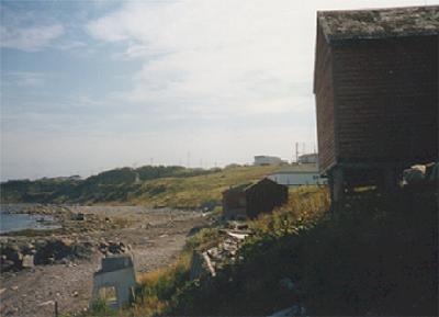
Figure 3. Road bed where black flake eroding out of road bed was located.
Revisit of Daniel’s Harbour 1 (EbBj-6):
After completing the assessment a nonintrusive investigation of the Dorset site at Daniel’s Cove was undertaken to check on the site’s condition. Very little is known about this site which was last visited by Callum Thomson and Scott Biggin in July of 1987. Thomsom wrote a brief site description in his report, “Archaeological Survey of Two Remote Cottage Areas at Parsons Pond and Portland Creek Pond.” The following is taken from that report:
Daniel’s Harbour 1, EbBj-6:
This appears to be an extensive Middle Dorset site, with a smaller Groswater component, situated on the west side of the town on the sloping ground above Daniel’s Cove. The site is now covered by dozens of fishing stores, as it was in 1928 when visited by Wintemberg (1939) and Jenness. Roads and downslope erosion have also caused much disturbance, but intact areas may still be found. Salvage is urgently required. (Thomson 1987:6). Wintemberg’s 1939 report contains the following information:
“A few chert chips and artifacts discovered by the writer at Daniels Harbor attest the presence of a small site. Most of it, however, is covered by buildings” (Wintemberg 1939:87).
This report also contains a brief description of a few artifacts from this site (ibid:90, 92).
A second article by Wintemberg, published the following year, has a photograph and description of an artifact collected, presumably, at this site in Daniel’s Cove. The description reads as follows:
“Another point, 5/32 inches thick (4.5 mm), chipped from light bluish-grey chert (Plate XVI, Figure 1, Number 7), has both faces and one side partly ground” (Wintemberg 1940:313).
Fishing stages still predominate the landscape at this site, as can be seen in Figures 2 and 3. Four flakes were observed eroding out of the gravel roads over a widely scattered area. All flakes appeared to be of fine grained Cow Head chert and were black in colour; none were collected (Figure 3).
As Thomson noted in 1987, this site is a prime candidate for future salvage work. A short term (i.e. two or three days), intensive field investigation of the site should enable a number of questions to be answered, such as site size and condition, focusing on locating any undisturbed areas. Confirming a Groswater presence and defining spatial differences, if such exist, between that and the Dorset component would also be useful.
References
Thomson, Callum J.
1987 – “Archaeological Survey of Two Remote Cottage Areas at Parsons Pond and Portland Creek Pond.” Report on file, Culture and Heritage Division.
Wintemberg, W.J.
1939 – “Eskimo Sites of the Dorset Culture in Newfoundland.” American Antiquity 5(2):83-102.
1940 – “Eskimo Sites of the Dorset Culture in Newfoundland.” American Antiquity 5(4):309-333.