
Archaeology in Newfoundland and Labrador 1996
Edited by K. Nelmes
A Stage 1 Archaeological Assessment of an Outfitter’s Lodge on the Eagle River, Labrador
Ken Reynolds
On Friday the 25th of October 1996, Ken Reynolds of the Culture and Heritage Division, accompanied a field assistant and a representative of the Goose Bay Provincial Wildlife Division to the site of construction of an outfitters camp on the second steady of the Eagle River. An archaeological assessment was deemed necessary because of the importance of the Eagle River as a known travel route and subsistence/economic exploitation zone for historic peoples (both settlers, Innu and perhaps the Inuit) and a probable location for prehistoric site remains.
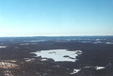
Figure 1. View of the terrain en route to Eagle River. (The Mealy Mountains are in the background.)
The sport fishing lodge is located on the second steady of the Eagle River, an estimated 24 to 25 km from the river’s mouth in Sandwich Bay. The area chosen for the lodge is on a high, treed terrace (10 m on average above the river) at a point in the Eagle where it widens from around 300 m directly in front of the lodge, to about 600 m at 0.75 km downstream. At this point the river runs moderately fast and appears quite shallow. The high banks and combination of width and shallowness would appear to make this a poor area for either historic or prehistoric camp site locations as access both to salmon and or caribou resources would be difficult.
This general area had been the site of a previous salmon lodge (a storage building still stands about 1/2 to 1 km downstream) which was subsequently moved further upstream so as to access better salmon fishing areas. From the Wildlife Division representative I gathered that while the river directly in front of the lodge can be fished, the operators plan to employ a helicopter service which would enable them to offer a wider number of fishing spots to their customers. Its less than prime salmon procurement location make it seem an unlikely spot for either historic or prehistoric sites.
As a possible location for intercepting caribou as they cross the river, this area again seems to be of low potential. Access to the river proper is difficult because of the height of the banks. One very steep graded path with a line attached to the trees was the only safe access to the river. No clearly defined large animal trails leading to the river were noted in the general area. It is possible that in the prehistoric period access may have been easier. I am unaware of the extent of the Mealy Mountain Caribou herds’ range in the immediate area. The author intends to conduct research into caribou availability during historic and prehistoric times.
Trapping of furbearing animals was a primary winter activity in this region during the historic period and into the modern day, so sites bearing directly on this activity (the remains of trapper’s tilts probably being the most visible in the archaeological record) could possible have been located on or near the lodge. This would seem to be the most logical reason for using the terrace upon which the lodge is being constructed. However, no signs of these, or any other man-made activity, were discovered.
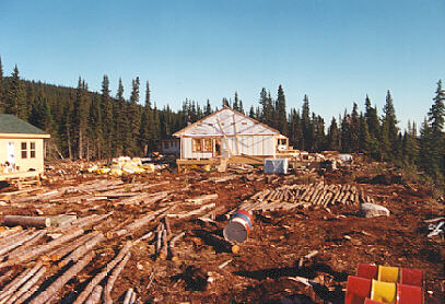
Figure 2. View of main lodge, looking east. Far left is the guide’s house. Note the number of logs covering the ground.
The area itself was heavily treed (mainly balsam fir and a few birch) as evidenced by the number of stumps, roots and logs scattered around the lodge site. Dozens if not hundreds of logs are covering the ground, acting as helicopter pads and presumably as a solid surface during periods of heavy rains. The large number of logs throughout the construction site meant that test-pitting had to be conducted around the log distribution. Eleven test pits where dug by the author and the assitant, all of which were sterile. Charcoal was found in some of the pits attesting to a forest fire in the area at an unknown date. The stratigraphy of a typical test pit consisted of an upper decomposing organic layer, followed by white sand, and in some cases a layer of medium to larger sized rocks followed by an orangy-brown sandy subsoil. From an archaeological perspective any evidence of previous use of the area should have been found from just below the beginnings of the organic level to the top of the white sand layer which on average was about 10-15 cm thick. No above-surface features were noted. The amount and type of clearing activities would have probably destroyed any evidence of such features if indeed they had existed.
Areas of ground disturbance were checked for signs of historic resources. These included a large hole dug for the septic tank located behind the main lodge on the forest side. Smaller trenches also ran from the guide’s residence to this tank. The sides of the walls of these holes, as well the accumulated back dirt, were inspected by the author and his assistant. Nothing was noted other than the signs of the forest fire(s). As well, a large garbage burning area on the river side of the lodge was investigated, again with negative results.
In conclusion, the outfitter’s camp on the Eagle River is free from historic resources and the need for further archaeological assessment will not be required.