
Archaeology in Newfoundland and Labrador 1996
Edited by K. Nelmes
Lester/Garland Premises Archaeology Project, 1996
Roy Skanes
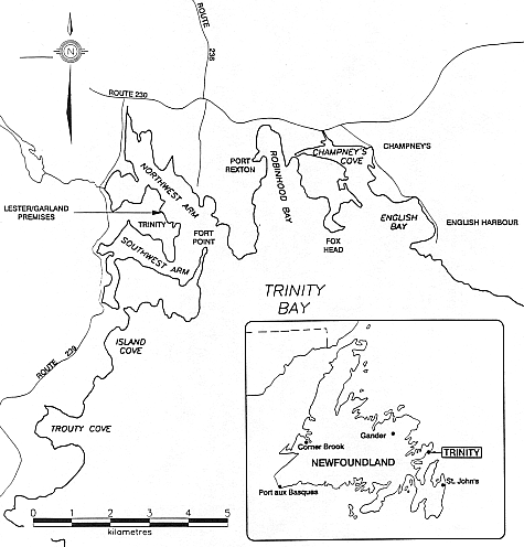
Figure 1. Study Area.
Background
The rebuilt three-storey Georgian-style brick house in Trinity, a key element of the Lester/Garland Provincial Historic Site, is situated on the west side of Northwest Arm at the extreme north end of the community (Figure 1). Demolished in places to near ground-level by its owners in the 1960s, only parts of the two gable-end walls up to roughly the level of the second floor remained of this prominent historic landmark. In November of 1991, the Trinity Trust-Canada Inc. (TTCI) was established as a registered non-profit organization to raise funding to reconstruct the brick building on the foundation of the dilapidated structure. The principal objective of the endeavour was to provide a visible means of interpreting the historic links between Poole (southwest England) and Trinity, and the role Trinity played as a centre of trade in the eighteenth and nineteenth centuries (Handcock 1996). Construction of the house commenced in October of 1996 and it was officially opened to the public on 25 June 1997.
Previous Site Research
In 1993, Dr. Gordon Handcock was contracted by the Historic Resources Division of the Department of Tourism and Culture (currently the Culture and Heritage Division) to conduct research into the construction history of the building and the social aspects of its occupancy (Handcock 1996). The initial archival study was supplemented with an archaeological field investigation undertaken by Kevin McAleese in August and September of the same year, hereinafter referred to as Stage 1. Results of the McAleese project indicated that a number of periods of occupation were represented at the site and that further field study should be carried out if construction of the building was to proceed (McAleese 1994).
In January of 1995, the terms of reference for an intensive archaeological investigation of the Lester/Garland Premises were prepared by the Historic Resources Division and forwarded to the project proponent, TTCI. It stated that complete excavation of the house ruins, and testing of all areas that would be impacted by associated construction activities must be completed prior to commencement of any development. In the summer and fall of 1995, archaeological research continued at the site for a period of approximately fifteen weeks (Skanes 1996).
Due to the expanse of the site, all the required archaeological excavation and testing was not completed in 1995. As a result, research continued in 1996 for a period of eighteen weeks.
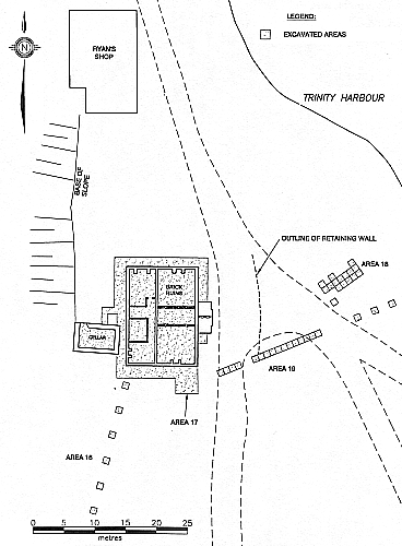
Figure 2. Lester/Garland Premises Study Area.
Over the course of the two field seasons, the entire inside of the ruins was excavated to an underlying sterile soil composition, as was a 1.5-2 m wide buffer zone around 90% of the building, and all on-site areas where ground disturbance would occur. This included the domestic waterline corridor from the Trinity Interpretation Centre to the house, the location selected for the septic tank, and two possible options for a sewage outfall pipe. As well, the extant back wall and underlying stone foundation of the house, roughly 75% of the front foundation, all interior stone and brick partitions, the kitchen, dining room, and conservatory fireplaces and chimneys (including the stone bases), and the entire foundation of the front porch was removed by the archaeological crew (Figure 2). Having the opportunity to systematically dismantle these features and collect the artifacts from within and/or below the brick and stonework was, from an archaeological/interpretive viewpoint, critical. Even though not slated for development in the near future, the brick cellar adjacent to the southeast corner of the building was thoroughly cleaned of rubble and gravel, and covered with a weather-tight wooden cap to ensure its long-term stability.
Approximately 15,000 artifacts including ceramics, clay smoking pipe fragments, glass, faunal remains, and several thousand metal objects were collected from the site for study. The field laboratory on the second floor of the Ryan’s Shop adjacent to the work area allowed all cultural materials to be cleaned, catalogued and prepared for research and analysis immediately following removal from the ground. The artifacts, as well as numerous scale drawings and photographs of specific structural details and stratigraphic soil profiles, will be of importance for developing an accurate understanding of the history and occupation of the premises, and ultimately could form an integral part of a comprehensive interpretive display for the visiting public.
Research Results
Analysis of the data recorded in 1995 and 1996 is currently ongoing. Therefore, a presentation of final results is not possible at this time. Nonetheless, tentative conclusions regarding the age and significance of the brick building and a number of on-site features are provided. A final site report, complete with illustrations and photographs, is currently in progress and should be ready for submission in the coming months.
The Brick Ruins
Based on the age of a large quantity of ceramics and clay smoking pipe fragments, and an interpretation of the context from which they were recorded, it is almost certain that the brick building was erected in its entirety in the early nineteenth century. Even though the structure most definitely underwent extensive interior and exterior renovations and repairs subsequently, the initial phase of construction most likely took place between the years 1819-21. These dates are apparently identified in the documentary record as a time when such work took place at the site (Handcock 1996), and a significant quantity of artifacts corresponding to that general time period (that is, the first half of the nineteenth century) recorded in builders’ trenches directly adjacent to the foundation, in the clay bonding-agent used in the stonework, and beneath the foundation footing on undisturbed, sterile subsoil, support this conclusion.
In order to clarify the above assertion, it is important the reader understand one of the most basic premises of archaeological inquiry, the principle of association: If a structure such as a stone foundation was erected in the 1760s, for example, any artifacts directly associated with it must also date to the 1760s, or earlier. Similarly, if erected in the early nineteenth century, artifacts determined to be in the context of construction must also be from that era, or before – they simply cannot be later. Even taking into account the fact that virtually all artifact categories, including ceramics and clay smoking pipes, have what are referred to as “production histories” (meaning, certain types were manufactured during a specific time period), the principal still applies. In archaeological parlance, artifacts provide a terminus post quem, by which is meant a deposit or feature can be dated to no earlier than the most recent object found in, or directly associated with it (Noel Hume 1969:11, Deetz 1993:69). Because a large quantity of refined earthenware sherds firmly dated to the period 1780-1830 were irrefutably present in such a context within the brick ruins, it is logical to assume that the structure post-dates the early limit of the identified date range. Even though it has been suggested by others that the building was originally constructed in the mid-eighteenth century and renovated subsequently with the addition of a third storey (McAleese 1994, Handcock 1996, 1997), the most recent archaeological data, and a reevaluation of the documentary evidence and the cultural materials unearthed during the Stage 1 study, suggests otherwise.
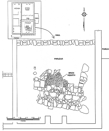
Figure 3. Chimney Case and Hearth in Relation to Brick Building Foundation.
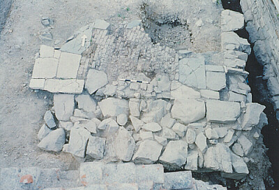
Figure 4. Completely Excavated Stone Chimney and Brick Hearth.
An Earlier Building
Excavation inside the perimeter of the foundation resulted in the discovery of remains of another building, thus confirming that the site was in fact occupied prior to construction of the large Georgian-style house ca. 1819-21. Situated in the southeast corner (in the ruins beneath gravel and clay fill, approximately 50 cm below the ground-floor level of the early nineteenth century dwelling) was a section of a dry-laid stone chimney and brick hearth. The feature was initially unearthed in 1995, but due to time constraints, was not fully exposed and recorded until the summer of 1996 (Figure 4). The dimensions of the configuration are approximately 3.6 m N-S x 4 m E-W, and it appears to have been oriented slightly diagonal to the south gable-end wall of the brick building (Figure 3). An analysis of the ceramic assemblage from fill covering the brick and stonework indicates that the structure was buried in the early nineteenth century.[1] Moreover, it is evident from the physical position of the remains in relation to the ca. 1819-21 century foundation, and soil profiles from this sector of the site, that the chimney (and presumably the building of which it was a part), was dismantled to make way for construction of the brick mansion. In sum, the physical evidence, both artifactual and stratigraphic, indicates clearly that these two events are connected and contemporary.
It is known from documentary sources that the west-country merchant, Benjamin Lester, constructed a large, double-gabled family dwelling in Trinity during the years 1763 and 1764. An eighteenth century oil painting of his mercantile establishment suggests that the house was situated in virtually the same location as the brick building (Handcock 1996). Because we know that Lester’s house was still occupied in 1819, even though in an extremely advanced state of disrepair, it is highly probable that the stone and brick remains discussed above are components of that structure. Unquestionably, the artifact assemblage recorded on top of the older hearth dates to the appropriate time period, and the overall sequence of events as interpreted from the archaeological record (that is, destruction of one building, construction of another, and ultimately backfilling) is, in the opinion of this author, supported by the documentary data. In fact, there is more than good reason to believe, based on passages contained in two letters written by George Garland, that the Lester dwelling from the 1760s was a wooden structure, and that in the early nineteenth century, because it was leaking severely due to the lodgement of snow and ice between the double-gable, it was torn down (cited in Handcock 1981:18-19). It may be that the line of stones forming the back of the older chimney also defined the end wall of Lester’s mid-eighteenth century Trinity home (Figures 3 & 4). Analysis of other artifacts from a thin layer of beach-gravel and sand beneath the brickwork may provide information as to when the structure was originally built and any repairs/modifications implemented over time. Such research is currently ongoing and results will be presented in the final site report.
Building Perimeter
The garden between the brick house and the Trinity Interpretation Centre was tested for the presence of archaeological remains. In total, six 1 x 1 m test units, spaced at 3 m intervals, were excavated along a corridor selected by the project engineer as the route of the domestic waterline from the Trinity Interpretation Centre to the brick building (Figure 2: Area 16). While a number of artifacts dating to the eighteenth, nineteenth and twentieth centuries were recorded in a somewhat mixed context, no features or deposits of archaeological significance were identified.
Excavation adjacent to the north wall of the brick building on the outside resulted in the discovery of a portion of an elaborate and extremely well-preserved brick drainage system. The feature extended the entire width of the building and, for the most part, was circular in cross-section. At the west end, however, it was somewhat more angular (Figure 5). Midway east-west along the north wall, the upper portion of the drain in two locations was flat and open, suggesting perhaps that a structure of some sort was situated above, possibly a privy or scullery, for example (Figure 5). Given that a large wooden kitchen for the staff was added to this end of the building in 1833 (Handcock 1996), it is likely that indoor sanitary facilities were incorporated at that time.
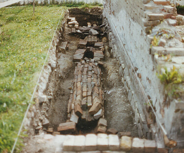
Figure 5. Drainage System at North end of House.
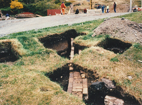
Figure 6. Section of Drainage System above Beach.
Excavation to the east of ruins revealed that the drainage system continues beyond the building’s northeast corner, down-slope towards the beach (Figure 2: Area 18). The discovery of intact remains at that location was significant in so far as it could indicate that additional components are in situ beneath the roadway where testing did not occur (Figure 6).
Subsequent excavation along the back (west) wall of the house revealed that the drainage system continues in a southwesterly direction towards the northwest corner of the cellar. Only a limited section of brickwork was unearthed at that location.
Because the terrain along the north and west sides of the house is frequently wet underfoot as a result of seepage from the base of the hill, it makes complete sense that a drainage system would have been necessary to divert groundwater away from the buildings, particularly the cellar where perishables would have been stored. While not conclusive, soil profiles and artifacts recorded in association with the drain suggest that it was laid subsequent to construction of the brick house in the early nineteenth century. Given that major renovations and alterations to the property were implemented in 1833, including construction of the wooden kitchen and brick cellar (Handcock 1996), it is reasonable to conclude from the available evidence that the drainage system was installed at that time. As well, because it is known for certain that the cellar was constructed in 1833, and because the drainage system appears to connect to it, this provides further support for the identified time period.
Excavation adjacent to the south wall of the building found no evidence of a subsurface drainage system. There was, however, remains of a low brick retaining wall. Because the natural topography of this sector of the site is quite sloped, it would appear that at the time of construction excavation into the bank to a depth of approximately 1 m below grade was necessary to position the foundation footing at the same level so that the ground floor of the building would be the same elevation throughout. The masons must have anticipated that when the reasonably deep builder’s trench was backfilled, the weight of the earth against the wall could cause undue stress and eventually result in structural problems (i.e. the brick and stonework bowing inward). In this instance, a subsurface wall to absorb the pressure would be a practical solution. Even though not an extremely important find, its presence is informative in that it provides insight into the natural topography of the area as it existed at the time of construction and the degree of ground preparation required.
Field work in 1996 also included excavation of three 1 x 1 m test squares adjacent to the southeast corner of the house (Figure 2: Area 17), and a 1 x 16 m trench to the east (Figure 2: Area 19). Investigation was conducted at these locations to ensure that no remains of heritage significance were disturbed or destroyed during installation of the septic tank or the underground sewage outfall pipe.
In the course of research, what appears to be a substantial mortared-stone retaining wall with several tiers of brick at the top, was identified just below the surface at the west end of the trench. The base of the wall extended to 1.2 m below surface and rested on a concentration of organic material, very likely decomposed sod. Artifacts and soil profiles recorded in association with the stonework suggest that it was erected in the early nineteenth century. It seems likely, therefore, that it is directly associated with the brick building. Its general location and configuration further support this assertion.
A reasonably well-defined and slightly curved alignment of large stones extends beyond the western end of Area 19, in a roughly northerly direction, across the level raised area in front of the house, towards the Ryan’s Shop. There can be little doubt that this configuration connects with, and is a continuation of the unearthed section of retaining wall. Based on its predicted age and associations, it seems likely its construction was required because the natural slope of the ground in the early nineteenth century was such that sufficient, level terrain in the location selected for the proposed new building did not exist. The fact that the hill behind the house was also modified, supports this conclusion. If suitable space was available, the house could simply have been positioned further east towards the water, but this was clearly not the case. Therefore, terracing the outer edge of the property may have been the most practical solution to the problem.
As mentioned, the retaining wall unearthed at the western end of test Area 19 was capped with several tier of bricks, and the alignment of stones to the north appears to have a slightly curved outline. A question arising from this is: are these features decorative, or purely functional? It would seem that if the structure was designed strictly to retain fill, and therefore would ultimately be buried, one would probably exert the effort to neatly position bricks on top of the wall. If, however, it was the intention that the top of the wall be visible above ground, laying brickwork along it, perhaps in an ornamental pattern, would be much more aesthetically pleasing. As well, a slightly rounded terrace in front of the mansion, overlooking the harbour and shoreline components of this extensive maritime enterprise, would generate a much more striking and lasting visual image.
A cursory cleaning and examination of the terrace revealed that it may have been paved with bricks. In a number of locations bricks are visible on the surface and it is obvious they were purposely positioned, one directly adjacent to the other. Similar assemblages were observed during excavation of the buffer zone along the front wall of the building in the vicinity of the porch. Even though the surface in front of the house has been severely disturbed by vehicular traffic and snow ploughs, certain sectors appear less affected than others. Consequently, it is possible that further evidence of paving is present. Given the social standing of the proprietors and the time-period, such landscaping would not be uncommon. In fact, it would be surprising if the entrance area was surfaced solely with gravel.
Conclusions
In 1995 and 1996, a total of thirty-five weeks of archaeological research was conducted at the Lester/Garland Premises in Trinity. The results of the investigation indicated that the large Georgian-style brick building was erected in its entirety in the early nineteenth century, probably between 1819-21. Excavation around the perimeter of the structure led to the identification of a number of associated features that provided new insight into the construction history of the building and the cultural landscape of the time. Included are a low brick retaining wall from 1819-1821, an elaborate brick drainage system most likely dating to the 1833 renovations, and a massive stone retaining wall that appears to have comprised part of a paved terrace in front of the house. Moreover, the base of a dry-laid stone chimney and brick hearth thought to be part of Benjamin Lester’s large double-gabled home from the 1760s was located inside the perimeter of the brick building beneath 0.5 m of construction fill. This find is of great significance in that it confirms that at least two dwellings occupied the site, and that one was demolished in the early nineteenth century to make way for construction of the other.
Recommendations
Without question, much could be learned through further field testing and selective excavation of specific areas on and adjacent to the Lester/Garland Premises in Trinity. Locations where results could be rewarding include: a) the yard between the house and the Ryan’s Shop; b) the terrace in front of the house; c) the shoreline below the reconstructed brick building; and d) the natural terrace behind the Ryan’s Shop.
Yard
To date, the yard between the Ryan’s Shop and the house has received only minor attention from an archaeological perspective. Because it is known from documentary material that this sector of the site was most definitely utilized to a significant degree by the Lesters and Garlands, it would be extremely valuable to determine what exactly this activity involved. Were other buildings constructed here, and if so, what were they used for? A determination of whether the yard was occupied prior to the 1760s, which is highly likely, would be extremely valuable from an interpretive point of view.
Another location within the general area that should be investigated include the back of the house towards the cellar where remains of the brick drain were identified.
Front of the House
Based on the most recent data, the level terrace in front of the brick house is almost certainly one of the most promising locations for archaeological investigation on the entire premises. The potential here is significant for a number of reasons. First, there is evidence to suggest that the terrace was paved with bricks. Archaeological research could, therefore, confirm or refute this assertion and, if true, establish its overall physical boundaries. The potential for future development of such a feature would clearly be of significance.
Secondly, the curved alignment of stones in front of the house appear to be the top of a retaining wall. Testing at various locations along the feature would substantiate its purpose, outline, and overall design. Establishing just how far to the north and south it extends may shed some light on the historic contours of the premises, and the way in which the area between the house and the Trinity Interpretation Centre has been modified over time.
Finally, it was determined through excavation of the trench for the sewage outfall pipe (Figure 2, Area 19), that the stone and brick retaining wall extends to 1.2 m below surface. If that depth, or height of the wall, is more or less consistent all the way along in front of the house, it would indicate that a substantial quantity of fill was deposited to create the raised terrace. The question arising from this, therefore, is: were any older building remains buried at the time of construction, and if so, what are they? Because it is known that at least one structure on the site was dismantled in the early nineteenth century to make way for the new house, and because the orientation of the older dwelling (as determined from the archaeological evidence) was slightly diagonal to the main axis of the brick building (Figure 3), it is possible that additional structural components related to the chimney and hearth could be extant beneath the terrace fill. If that proved true, it might be possible to determine the exact length and orientation of the older building, gain some understanding of the interior ground-floor plan, and obtain a more accurate determination of its age. From an interpretive standpoint, such a find would clearly be invaluable.
The Beach
The beach of the premises directly in front of the rebuilt mansion is known to have been used by the Taverner, Lester, and Garland families for fisheries related activities for at least two hundred years. Structures that would have been built along this stretch of coastline, and ones that could be detected and dated through archaeological inquiry include net lofts, fish sheds, workshops, boat-building areas, and the landward components of wharfs, stages, slipways, etc. As well, due to the documented history of Trinity, which extends to at least as early as the late-sixteenth century, the potential for findings in the area above the beach is relatively high.
Terrace behind Ryan’s Shop
It is known from documentary sources that the terrace behind the Ryan’s Shop was used for infrastructure facilities such as a powderhouse and cooperage. Testing, therefore, could provide additional information regarding the history and development of this longstanding mercantile enterprise.
1. Numerous fragments of blue shell-edged Pearlware dating to the period 1780-1830 were located directly on top of, and wedged in among the brick-work.
References
Deetz, James
1993 – Flowerdew Hundred: The Archaeology of a Virginia Plantation 1619-1864. Charlottesville: University Press of Virginia.
Handcock, Gordon
1981 – “The Merchant Families and Entrepreneurs of Trinity in the Nineteenth Century.” Copy available at the Centre for Newfoundland Studies, MUN.
1996 – “A Landmark of Legends: The Lester-Garland House of Trinity: A Review of Construction and Social Aspects of its Occupance. Report prepared for the Historic Resources Division, Department of Tourism and Culture. Copy on file with the Culture and Heritage Division, St. John’s.
1997 – The Story of Trinity. Trinity Historical Society.
Lockett, T.A. & P.A. Halfpeny (eds).
1986 – Creamware & Pearlware. The fifth exhibition from the Northern Ceramic Society. Stoke-on-Trent City Museum and Art Gallery.
McAleese, Kevin
1994 – “Lester/Garland Site Excavation, Trinity, Trinity Bay. Report prepared for the Historic Resources Division, Department of Tourism and Culture, St. John’s. Copy on file with the Culture and Heritage Division, St. John’s.
Noel Hume, I.
1970 – A guide to the Artifacts of Colonial America. New York: Knopf.
Skanes, Roy
1996 – “Lester/Garland Premises Archaeology Project: Stage 2 Excavation Summary.” Report prepared for the Trinity Trust-Canada Inc. Copy on file with the Culture and Heritage Division, St. John’s.
Towner, D.
1978 – Creamware. London: Faber and Faber.