
Archaeology in Newfoundland and Labrador 1996
Edited by K. Nelmes
Stage 1 Historic Resources Overview Assessment: Rattle Brook, Great Northern Peninsula, Newfoundland
Roy Skanes
Introduction
Background
A power company is proposing to construct a small hydroelectric generating station on Rattle Brook (a tributary to Great Coney Arm River) with an installed capacity of 4 megawatts (Figure 1). The undertaking will include construction of two access roads, a concrete dam, a headpond, a water intake structure, a 1000 m penstock, a powerhouse and a substation to interconnect with the existing Newfoundland and Labrador Hydro transmission lines.
The proposed hydroelectric project will be a run-of-the-river operation using only the natural flows currently existing. Because the Project Area is directly accessible from Highway 420, the on-site construction camp will be limited to a single mobile trailer.

Figure 1. Site Location. *
Project Rationale
Information on historic resources in the general vicinity of the Project Area was available from a literature review prepared for a study of the Main River (LeDrew, Fudge and Associates Limited 1989). The archaeologist that completed the review described a variety of sites situated along the west coast of the Great Northern Peninsula that were used by Maritime Archaic Indians, Groswater Paleo-Eskimos, Middle Dorset Paleo-Eskimos, and Recent Prehistoric Indian populations. Sites have also been discovered on the east side of the Peninsula at Jackson’s Arm (Penney 1980) and at Sops Island (Linnamae 1975). Speculation by these authors indicated the possibility for sites to exist inland, since interior sites have been discovered elsewhere on the Island. As well, both authors emphasized that the relative absence of data regarding interior occupations are likely more a reflection of the paucity of research that has been conducted in these areas rather than the actual level of past use. Following this rationale, it was reasonable to conclude that there was some potential for the presence of historic resources within the boundaries of the Project Area. Because certain project activities could result in an unintended disturbance or destruction of any such remains, a Stage 1 Historic Resources Overview Assessment was carried out.
Objectives and Scope of Work
The primary objectives of the Stage 1 Historic Resources Overview Assessment were:
- to identify and assess the historic resources potential or sensitivity within the Project Area; and
- to recommend the appropriate methodology and scope for further detailed impact studies, if indicated. Essential components of the assessment involved completion of a documentary search, direct consultation/informant interviews, a field survey, and production of an overview report.
Location
The proposed hydroelectric project is located on Rattle Brook, a tributary of Great Coney Arm River, approximately 4 km northwest of Jackson’s Arm on the Great Northern Peninsula of Newfoundland (Figure 1). This drainage basin is situated within the Long Range Mountains and contains elevations of between 230 and 530 m above sea level (asl). The highway to Newfoundland and Labrador Hydro’s Cat Arm Reservoir (Highway 420) crosses Rattle Brook approximately 150 m from the proposed powerhouse location and will provide year-round access to the site during construction and operation.
Physical Features
The principal physical features of the proposed development are shown in Figure 2 of this report and include the following components:
Access Roads
Access to the site will be by two short gravel roads (Figure 2). The primary purpose of the roads is to provide access to the facilities during construction. Subsequently, they will be used seasonally to access the intake and powerhouse areas. The centre line for both access roads was cut during the winter of 1995.
Dam
The purpose of the dam is to create an impoundment area which provides sufficient depth to convey the water into the intake. The dam, a concrete gravity structure of overtopping design, will be approximately 4 m in height. Stop logs and station blocks will be incorporated into the structure to allow for draining the headpond (Figure 2).
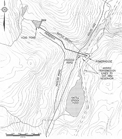
Figure 2. Plan of Proposed Hydroelectric Facility at Rattle Brook. *
Headpond
The dam will result in increased water levels extending upstream approximately 90 m, creating a headpond 0.90 ha. in size (Figure 2). Storage within the headpond will be approximately 7500 m3 and will have a turnover rate of less than 1 hour under average flow conditions.
Intake Structure
The purpose of the intake structure is to convey flows from the natural channel into the penstock. The intake must be submerged sufficiently to prevent air from entering the system. The intake will be equipped with a vault to halt the flow of water when necessary and an air vent to prevent penstock collapse in the event of a shutdown. The intake will also be equipped with a trash rake system to prevent the entrainment of debris from upstream (Figure 2).
Penstock
The purpose of the penstock is to convey water from the intake to the turbines. The penstock selected for the proposed development will be 1 m in diameter and will follow the route illustrated in Figure 2. The pipeline will be an above ground steel and plastic construction.
Powerhouse
The powerhouse will be located where the plant discharges the water back into the natural watercourse (Figure 2). The mechanical and electrical equipment (i.e. the turbine and generator), as well as the associated switch gear and controls, will be housed within this structure. Due to the relatively small size of modern turbine equipment, the overall size of the building will be equally small. The powerhouse will be surrounded by a safety fence and equipped with security doors.
Project Scheduling
A registration document for the Rattle Brook project was submitted to the Provincial Government in November, 1991. Approval without an Environmental Impact Statement was granted by the Department of Mines and Energy (currently Department of Natural Resources, Mines and Labour) on March 4, 1992. Permission for clearing the principal access right-of-way to the site (that is from Highway 420 to the dam) was given in early February 1995, and a commercial cutting permit was received on February 16. The road centreline was cleared prior to March 4, 1995.
It is anticipated that construction of the dam and associated facilities will begin in July or August, 1997, with the generating plant being on-line with Newfoundland and Labrador Hydro by the end of 1998.
Project Area
Geology
The Project Area is located within the Humber Zone, one of four principal tectonic divisions of insular Newfoundland. The Humber Zone contains the oldest bedrock in the province, some of which is thought to date to 1.6 billion years before present (i.e. to the Middle Proterozoic).
The bedrock in the Project Area consists primarily of gneisses and other rocks generally of granitic composition, with minor occurrences of metamorphosed mafic dykes, gabbros, and marble. These rocks were overlain or cut by younger sedimentary deposits or igneous intrusions of Cambrian-Ordovician age which were themselves subsequently deformed and metamorphosed during various tectonic processes that created the Appalachian Mountain system.
Vegetation
The Project Area falls within what is known as the Eastern Long Range subregion which is considered to be a part of the larger Northern Peninsula Ecoregion. This ecoregion comprises the forested parts of the Great Northern Peninsula, including the largely bog-covered marine deposits along the west coast. The forests of the area penetrate deep into the valleys of the Long Range Mountains. On the west side of the peninsula the ecoregion includes very little land above 200 m, however, on the more protected east side and in the southern sector, forests occur to altitudes of approximately 450 m asl (South 1983:179-180).
Balsam fir (Abies balsamea) is the predominant tree found in this ecoregion. At relatively high elevations, black spruce (Picea mariana) also becomes an important component. The vegetation in the area has a distinctly more northern appearance than areas at the same altitude on the west coast (South 1983:1790-1800).
Freshwater Fish
Atlantic Salmon (Salmo salar) and sea-run brook trout (Salvelinus fontinalis) are known to be present in the Coney Arm River system, situated north of the Project Area. However, given that Rattle Brook is totally obstructed near its mouth by the presence of a large waterfall, it is unlikely that the upper reaches of this tributary are inhabited by those species. Resident brook trout in small numbers are probably present above the falls. As a point of interest, it should be noted that the same gradients that make this section of the brook attractive for hydroelectric generation would likely inhibit the movement of resident brook trout (Algonquin Power Corporation Inc. 1991).
Avifauna
Twelve species of raptors are believed to occur on Main River situated to the south of Rattle Brook. Forest vegetation in the immediate vicinity of the Project Area, consisting generally of stunted growth, may however provide unsuitable nesting habitat for raptors such as bald eagles (Haliaeetus leucocephalus) and osprey (Pandion haliaetus). While several species of waterfowl including the American black duck (Anas rubripes), the green-winged teal (Anas crecca), the red-necked duck (Aythya collaris), the common merganser (Mergus merganser), and Canada geese (Branta canadensis), are known to inhabit this sector of the Great Northern Peninsula, numbers in the general vicinity of the Project Area are thought to be low (Algonquin Power Corporation Inc. 1991).
Mammals and Furbearers
Little data regarding caribou (Rangifer tarandus) populations in the general vicinity of Rattle Brook currently exist, and it is unclear whether one or both of the herds in the region are occupying the area. Some studies, however, have indicated that the Humber herd and the larger, more northerly, Northern Peninsula herd occupy this area throughout the year. Wintering areas have been identified in the vicinity of Rattle Brook with calving and summer range situated further west and north (Algonquin Power Corporation Inc. 1991). Observations during field studies on the nearby Main River (approximately 13 km south), suggest that caribou are attracted to the lush grazing available in the meadows and along the banks of that river (LeDrew, Fudge and Associates Limited 1989: taken from Algonquin Power Corporation Inc. 1991).
The Project Area is in moose (Alces americana) and black bear (Ursus americana) Hunting Area # 4. This area is considered to be relatively productive for both these species.
The general area supports relatively high numbers of furbearers including beaver (Castor canadensis), lynx (Lynx canadensis), snowshoe hare (Lepus americanus), muskrat (Ondatra zibethicus), mink (Musterela vison), red fox (Vulpes vulpes), ermine (Mustela erminea), otter (Lontra canadensis), and red squirrel (tamiascius Ludsonicus). The pine martin (Martes americana), which is currently designated as an endangered species, was introduced in 1976 and 1978 at Main River south of Rattle Brook and since then may have spread to reach the Project Area.
Methodology
Background Research
The following tasks were completed prior to the field survey:
- a search of the Newfoundland and Labrador Archaeological Site Inventory to determine if archaeological resources were registered for the general vicinity of the Project Area;
- a review of published and unpublished literature, including archaeological reports, maps and aerial photographs relevant to the Project Area and general vicinity; and
- informant interviews with an individual familiar with the area.
Field Survey
The field survey consisted of a thorough walk-over involving visual examination of all areas that could be directly impacted as a result of the development. Moreover, locations within the Project Area (i.e. level and well drained terraces above the river bank) that held even slight potential for the presence of historic resources were subjected to judgmental test-pitting. In all test locations, the upper sod/peat layer of an approximately 30 cm2 area was removed with a shovel, and subsequent soil layers were excavated to the underlying compact subsoil with a trowel. A photographic record of test pit locations in the Project Area was obtained.
Areas investigated as part of the Rattle Brook Stage 1 Historic Resources Overview Assessment are shown in Figure 2 of this report and included:
- both access roads;
- both sides of Rattle Brook from the dam to the powerhouse;
- the dam area;
- the entire length of the penstock;
- the headpond; and
- the location designated for construction of the powerhouse.
Additional areas surveyed for the presence of historic resources included:
- the shoreline along the north end of Rattle Brook Pond; and
- the east and west banks of the small river that flows from the pond and intersects with Rattle Brook at the proposed powerhouse location (Figure 2).
Survey Results
Background Research
A search of the Newfoundland and Labrador Archaeological Site Inventory at the Culture and Heritage Division indicated that no archaeological sites or materials are registered for the Project Area or the immediate vicinity. Furthermore, a review of published and unpublished reports available at that Division indicated that, with the exception of a limited investigation for the Upper Humber/Main River Wood Harvesting Operation (Northlands 1986), no in-depth archaeological research has been conducted in the interior of Newfoundland in the vicinity of the Project Area. Several surveys and excavations have, however, been undertaken along the west coast of the Great Northern Peninsula (Renouf 1985, 1986; Tuck 1970, 1971, 1976) and in White Bay (Penney 1980, Linnamae 1975). This research has indicated a long-standing human presence in the region spanning a period of approximately four and a half millennia. The occupation began with Maritime Archaic Indians approximately 4500 years before present (B.P.), followed by Early Paleo-Eskimo (Groswater) and Late Paleo-Eskimo traditions (Dorset), which persisted until shortly after c. 1400 B.P. (Brown 1988; Renouf 1986, 1985; Tuck 1970, 1971, 1976; Tuck & Pastore 1985). Recent Indian sites dating to between c. 1700 and 500 years B.P. have also been discovered.
In historic times, the coastal areas of the Great Northern Peninsula were occupied by a number of different European cultural groups including Basque, French and English (Barkham 1989). As well, it is known from first-hand accounts that the interior portion of the Island at the base of the Great Northern Peninsula was used by Micmac (probably from the south coast of the Island) for hunting and trapping. A reference cited in the journal of an individual who walked across the Island from the bottom of Green Bay to Bonne Bay in 1877 mentions a Micmac camp at the southwest end of Adies Pond, approximately 45 km south of the proposed hydroelectric development (Robinson 1877). Oral tradition also suggests that in this century the same region was referred to by residents of the Bonne Bay area as the “Indian burial ground” (taken from Elmer Harp’s Journal, 1949).
Based on the known resource profile for this sector of the province, and the cultural history summarized above, it was not unreasonable to assume that the groups known to have occupied adjacent coastal and interior areas could also have been drawn to this sector of the Island as well. The lack of data currently available to confirm such a presence was considered to be more a function of the paucity of research conducted rather than the actual level of past human activity. Because of the anticipated level of disturbance that would occur as a result of the hydroelectric development, archaeological investigation was warranted.
Field Survey
Access Roads
The access road to the dam commences at a point approximately 100 m west of the southwest end of Rattle Brook Pond and runs roughly parallel to Highway 420 for a distance of 875 m. From there, the road continues along the south side of Rattle Brook, an average distance of 100 m from it, to approximately 765 m northwest of Highway 420 (Figure 2). The terrain along the entire route of the road being densely wooded, rocky, and with an extreme slope, contained little or virtually no potential for the presence of historic resources.
The second access road from Highway 420 to the powerhouse will also extend over an area with an extreme slope. Moreover, a large portion of this access road was previously disturbed during construction of Highway 420. Due to these factors, the potential for the presence of historic resources here was also low.

Figure 3. Rattle Brook looking upstream towards proposed dam site. *
Dam and Headpond
The proposed dam and headpond will be situated approximately 750 m upstream from Highway 420 (Figure 2). The brook at this location, as it is throughout the entire Project Area, is extremely rocky and passes through a steep-sided and heavily wooded valley (Figure 3). Based on the topographic conditions in the area where the facilities will be situated, it is concluded that the historic resources potential is low.
Penstock
The 1 m diameter penstock will commence at the dam and extend downstream on the south side of Rattle Brook to the powerhouse situated on the east side of Highway 420 (Figure 2). The terrain along this section of river, and particularly where the penstock will parallel the waterfalls adjacent to the existing highway, is extremely rugged and would not have been attractive for human occupation.
Powerhouse
The powerhouse will be situated 150 m southeast of Highway 420 and approximately 280 m north of Rattle Brook Pond. The selected site is situated in close proximity to the existing hydro transmission lines to Cat Arm (Figure 2). The terrain in the area is extremely rugged and has experienced a certain amount of disturbance from road construction and installation of the transmission lines. As a result of these factors, the historic resources potential is considered to be low.
Additional Survey Area
The north end of Rattle Brook Pond, as well as the shoreline of the small river that flows from the pond and intersects with Rattle Brook (Figure 2), was surveyed for the presence of historic resources. This component of the study involved strictly a walk-over: no test-pitting was conducted. The results of this work revealed that at the mouth of the brook there are the remains of a dilapidated wooden dam. Information obtained from an informant in Jackson’s Arm indicates that the structure was used in this century to create a headpond in Rattle Brook Pond so that, when opened, the increased flow would be sufficient to transport logs downstream to a sawmill in Great Coney Arm. While it was not determined when the dam was initially constructed, it was apparently in use until c. 1940. Since then, the dam has fallen into disrepair. Currently, the extant remains are used by the resident beaver population.
In addition to the dam, on the east side of the river there are remains of what appears to be an access road. Based on the location and general appearance, it seems reasonable that the road was associated with the adjacent Cat Arm hydroelectric lines. An informant in Jackson’s Arm confirmed this suspicion.
Conculsions
Despite a thorough visual inspection of all areas of proposed impact, and subsurface testing at various locations, no historic resources of any description were identified in the Project Area. While the remains of a wooden dam associated with recent lumber operations was identified at the north end of Rattle Brook Pond, its location outside the Project Area indicates that it should not be directly impacted. The overall results undoubtedly reflect the generally unsuitable topography of the area which included an unnavigable rocky river with extremely steep and heavily wooded sides. As well, a lack of abundant food resources, such as fish and land mammals, may also have further rendered the area unattractive for prolonged human occupation. Other than perhaps hunting and fishing expeditions of short duration, and trapping of small furbearing animals and wood cutting (neither of which activity would necessarily leave significant remains), the area around Rattle Brook was probably not used extensively by either aboriginal people or Newfoundlanders of European descent in the distant or recent past. As a result of these findings, no mitigation measures are indicated.
Recommendation
Even though no physical evidence of past human occupation was discovered in the Project Area it must be kept in mind that a survey of this nature cannot be considered completely reliable, given that only a small percentage of the Project Area was actually tested. Even though remote, there exists the possibility that undiscovered archaeological materials such as butchered animal bones, graves, tools, structures and features may be unearthed during construction. Therefore, it is recommended that all personnel working on the project should be informed of this possibility and of their responsibility to report any suspected findings. In the event of a discovery of a historic or prehistoric artifact or archaeological site, the following procedures should apply:
- All historic resources, including archaeological objects and sites of archaeological and/or historic interest or significance discovered in the area will be deemed the property of the Crown, and must not be disturbed. The Contractor will take all reasonable precautions to prevent its employees or other persons from removing or damaging any such articles, artifacts or sites and may be liable for prosecution under Sections 35.1 and 35.2 of The Historic Resources Act, 1985, for all contravention.
- All work will cease in the immediate area of the discovery until the Resource Archaeologist of the Culture and Heritage Division authorizes a resumption of work.
- Archaeological materials encountered should be reported with the following information to Martha Drake, Resource Archaeologist with the Culture and Heritage Division at (709) 729-2462:
- nature of activity resulting in the find;
- nature of the material discovered; and
- the precise location of the find.
References
Algonquin Power Corporation Inc.
1991 – “Rattle Brook Hydroelectric Generating Station: Registration Form for the Environmental Assessment Act.” Document prepared for the Department of Environment and Lands. Copy on file with Jacques Whitford Environment, St. John’s.
Barkham, S.H.
1989 – The Basque Coast of Newfoundland. Great Northern Peninsula Development Corporation.
Brown, S.C.
1988 – “Archaeological Excavations at the Crow Head Cave and the Gargamelle Rockshelter in the Port au Choix National Historic Park, Newfoundland.” Report prepared for the Historic Resources Branch of Parks Canada, Halifax. Copy on file with the Culture and Heritage Division, St. John’s.
Government of Newfoundland and Labrador
1992 – “Historic Resources Impact Assessment guidelines.” Culture and Heritage Division, Department of Tourism, Culture and Recreation. St. John’s.
Harp, Elmer
1949 – “Journal Entries for Newfoundland and Labrador.” Copy on file with the Culture and Heritage Division, St. John’s.
Linnamae, U.
1975 – “The Dorset Culture: A Comparative Study in Newfoundland and the Arctic.” Technical Papers of the Newfoundland Museum # 1, St. John’s.
Penney, G.
1980 – “Archaeological Assessment of the Cat Arm Hydro Development.” Copy on file with the Culture and Heritage Division, St. John’s.
Renouf, M.A.P.
1985 – “Excavations at Phillip’s Garden and Point Riche, Port aux Choix National Historic Park.” In Archaeology in Newfoundland and Labrador 1985. Edited by J. Sproull Thomson and Callum Thomson, pp. 159-195.
1985 – “Report of Archaeological Investigations at the Port au Choix and Point Riche Peninsulas.” In Archaeology in Newfoundland and Labrador 1984. Edited by J. Sproull Thomson and Callum Thomson, pp. 298-321.
Robinson, George
1877 – “Journal of Staff-Commander, George Robinson, R.N.” Published in the Royal Geographic Society’s Journal, 1877. Copy on file with the Culture and Heritage Division.
South, G. Robin
1983 – Biogeography and Ecology of the Island of Newfoundland. Dr. W. Junk Publishers, The Hague-Boston-London.
Tuck, J.A.
1970 – “An Archaic Indian Cemetery in Newfoundland.” Scientific American 226(6):112-121.
1971 – “An Archaic Cemetery at Port au Choix, Newfoundland.” American Antiquity 36(3):343-358.
1976 – Ancient People of Port au Choix, Newfoundland. Institute of Social and Economic Research, M.U.N. Social and Economic Studies # 17. St. John’s.
Tuck, J.A. and R.T. Pastore
1985 – “‘A Nice Place To Visit, but…’ Prehistoric Human Extinctions on the Island of Newfoundland.” Canadian Journal of Archaeology 9(1):69-80.
*Maps by Jacques Whitford Environment; photo by Roy Skanes.