Archaeology in Newfoundland and Labrador 1997
Edited by K. Nelmes
Field Report for the 1997 Fleur de Lys Archaeology Project
John Erwin
Work Summary for 1997
In 1996 the Dorset Soapstone Quarry Association was awarded a grant from the Newfoundland Economic Renewal Program for the development of a museum and interpretation centre in the town of Fleur de Lys, Newfoundland. In conjunction with this development, a regional archaeological survey and excavation program are being undertaken to develop a greater understanding of the archaeological resources and the prehistory of the Baie Verte region. The centrepiece of the project is the Dorset Palaeoeskimo soapstone quarry site, Fleur de Lys 1 (EaBa-1), which was awarded National Historic status in July of 1996, and is the present focus of recent archaeological investigations that commenced in July 1997.
The Fleur de Lys site consists of an extensive series of heavily-worked soapstone outcrops which bear the scars of several hundred years of Dorset quarrying activities for the production of soapstone vessels. Fieldwork in 1997 was directed at three principal objectives:
- the block excavation of a large contiguous area immediately below one of the main quarried loci at the site in order to remove spoil from the front of the quarried cliff and to further expose the worked face, as well as to add to our understanding of the extent and nature of quarrying activities that took place there. A total of 23 one metre units were fully or partially excavated with over 1100 artifacts collected, which consisted primarily of various types of Dorset quarrying tools. In a waterlogged clay lens near the base of the deposit, a number of wooden poles were uncovered that may have been part of the Dorset quarrying tool kit, or they may have been part of a scaffolding structure. Samples of these have been submitted for radiocarbon dating.
- documentation of preforms and preform removal scars in several loci (1D-1G) that had been inaccessible in previous visits to the outcrops due to extremely dense vegetation cover.
- conducting preliminary surveys along the surrounding Baie Verte coastline. These resulted in the discovery of a Palaeoeskimo house structure and habitation site at Plat Bay Cove on the northernmost point of the peninsula.
Plans for the 1998 season include: (1) a comprehensive archaeological survey of the entire Baie Verte Peninsula; (2) the completion of area excavations and documentation of quarried loci at Fleur de Lys 1; and (3) complete excavation of the Dorset house structure and associated deposits at Plat Bay Cove. [1]
This report is divided into three main parts: (1) the excavations at Fleur de Lys 1; (2) the survey and test pit work conducted on the Baie Verte Peninsula; and, (3) summary and conclusions.
Part 1 – Excavations at Fleur de Lys 1 (Eaba-1) – Locality 1, Group B (North)
Despite past investigations at this locality (Nagle 1982; Thomson 1983, 1984, 1986, 1987), no excavation has completely determined the depth of the deposits adjacent to the quarry face since these previous tests were halted less than a metre below surface due to flooding. The current Fleur de Lys project has been able to continue below these levels with the aid an electric water pump and 15 metres of plastic piping which moves the continuous flow of water away from the excavation. The 1997 excavations attained a depth up to 1.3 metres below surface in some units. The removal scars on the quarry face continue down below the lowermost levels, to a yet undetermined depth. It is planned that these excavations will be completed in the summer of 1998.
(i) Site Preparation:
During the week of August 4-11, 1997, much of the brush and debris was removed from the area revealing numerous preforms and preform removal scars in several loci a long the quarry face that had been inaccessible in previous visits to the outcrops.
Prior to excavation, six 50×50 cm test pits were excavated to a depth of approximately 50 cm along the east side of the boardwalk (Figure 1) within proximity of the eventual location of our screen and backdirt piles. This was undertaken prior to screening operations as a means to determine where to locate backdirt and rock piles to avoid unnecessary disturbance of undiscovered archaeological features.
The stratigraphy of these test pits generally consisted of two fairly well defined layers. The upper 20 cm consisted of black-brown loam which contained many stones, and a few unworked soapstone fragments. The lower layer (approximately 50 cm) was characteristically reddish-brown in colour [2] containing numerous large rocks, some unmodified soapstone fragments and a single modified vessel fragment found in Test Pit 6. As no archaeological features were discovered in this area, rock piles were located in the northern portion of the test area, and screened soil was spread out over the southern extent.
A seventh 50 x 50 cm test pit was excavated on the west side of the boardwalk (Figure 1), with the intention that a permanent datum peg would be cemented in place. This idea was abandoned after the excavation filled with water at a depth of 30 cm. No artifacts were recovered from this test pit. However, numerous unmodified soapstone fragments were noted.
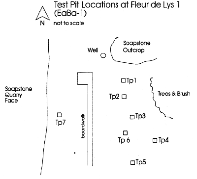
Figure 1. Test Pit Locations at Fleur de Lys 1 (EaBa-1)
(ii) Survey and Measurement of Cliff Face:
Given that a recent Land Survey Plan in 1996 did not contain an accurate rendering of the cliff face, we undertook a brief survey with the theodolite and mapped the extent and location of this feature. To do this we located survey markers along the Johanna Walsh Grant boundary and established a datum line along the length of the locality. From this line, we measured the approximate location of the quarry face using tape measures. A final site plan from this survey will be produced in the summer of 1998.
(iii) The Excavation:
The purpose of this excavation was to further expose the worked face of the quarry, and to add to our understanding of the extent and nature of quarrying activities that took place at this locality. A total of 36 one metre square units were laid out directly abutting the quarry face (Figure 2). The excavation of this large contiguous area began August 4 and was closed September 16, 1997. During this period, a total of 23 one metre square units were opened.
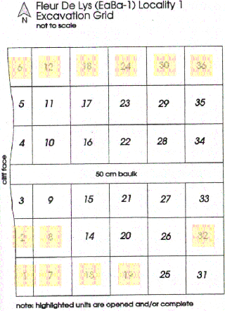
Figure 2. Fleur de Lys (EaBa-1) Locality 1 Excavation Grid
Initially, we opened six units as a trench perpendicular to the quarry face (nos. 4, 10, 16, 22, 28, and 34) as a test and control for the remainder of the excavation. Based on this initial excavation, we determined that the original ground surface in the area was about 60 cm below the surface at about 5 m from the quarry face (unit 34), and is marked by a blackened and burned palaeosol. As such, it is proposed that the vegetation in proximity to the quarry face was burnt quite early on in the use of the site, probably as a means to gain easier access to this valuable resource. The depth of this layer below surface varies according to site topography. Interestingly, this blackened layer does not occur within the approximately 1.5 metres of the quarry face, suggesting that this area was dug out by Dorset peoples at some time after the initial burning of the vegetation to access additional soapstone below the original ground surface (Figure 3). This appears to be the case, as we continue to find removal scars on the soapstone, well below the original ground surface.
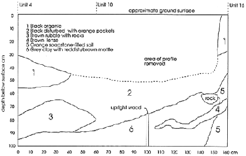
Figure 3. EaBa-1: North Profile of Units 4 & 10.
(iv) Waterlogged Wooden Structure:
Since this site has previously yielded little preserved organic material, the finding of a preserved wooden structure near the quarry face was quite an unexpected and fortuitous development. This feature is located within at least five excavation units (nos. 3, 4, 5, 10 and 11) (see Figure 2) at a depth of approximately 100 cm below the surface. Since we were not able to expose the entire structure during the 1997 field season, it was re-buried under approximately one metre of soil before capping the entire excavation for the winter.
Initially we believed that this structure may have been the remains of an historic well, since: (1) there was considerable disturbance in the layers above; (2) a constant flow of water percolated up from beneath this unit; and (3) there are shallow wells in this area with wooden support structures. From the ground surface to about 60 cm below surface, the soil consisted of a black peat-like matrix, which contained a mix of historic and prehistoric artifacts (e.g. flakes, soapstone pots, pot fragments, a bullet cartridge, a bottle cap, ceramics, etc.).
Below this disturbed level is a finely layered grey clay layer with water-sorted reddish-orange mottling which completely envelopes a series of modified wooden timbers that cross one another at roughly right angles (Figure 4).
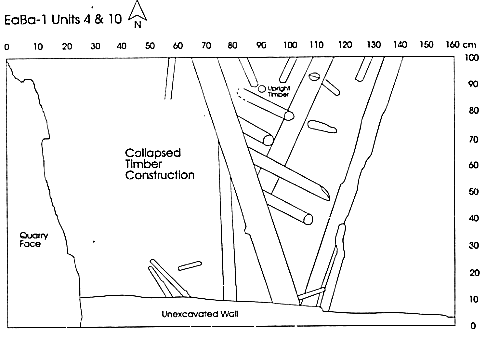
Figure 4. EaBa-1: Units 4 and 10
The orientation of this structure is roughly parallel with the quarry face. Within this layer, which is at least 40 cm thick, no historic artifacts were recovered. However, it contained numerous Dorset quarrying tools (e.g. choppers and scrapers) and soapstone vessel fragments, including finished incised rectangular lamp fragments. The timbers showed no signs of historic modification (e.g. nails or saw marks), but rather had a few large “open” chop marks that were more characteristic of a stone implement, rather than the thin edge of a steel axe. In addition, the orientation of smaller timbers over larger ones at right angles suggests that the structure is relatively undisturbed by post-depositional processes; and that the timbers were probably bound together in this pattern with some lashing that has since been lost to preservation.
Finally, a sample of this structure was sent to Beta Analytic for radiocarbon analysis. An uncalibrated result of 1610 ± 60 B.P. [3] was returned on April 29, 1998. This has been calibrated to AD 430 at one sigma (Stuiver & Reimer 1993). This age compares favorably to a previous 14C result of 1220 ± 110 taken from a wood charcoal sample retrieved well above this layer (42 cm below the surface) as reported by Thomson (1986:200).
(v) Artifacts Collected:
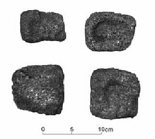
A full range of artifacts are identified from the 1100 plus artifacts collected during the 1997 field season. These include: (1) quarrying tools made from a greenish colored metamorphic sandstone such as: tabular scrapers, picks, chisels, hammerstones, axes, adzes, and large bifacially worked choppers; (2) non-quarrying tools including greenish-gray colored chert endblades, a quartz microblade, a thumbnail scraper and a number of chert flakes; and (3) a variety of soapstone vessels and vessel fragments ranging from 5-10 cm to 25-35 cm in diameter (see photos in Appendix).
Part 2 – Preliminary Survey of Baie Verte Peninsula
Although the soapstone deposits at Fleur de Lys represent the largest and most extensively worked Dorset quarry site known of its kind, there are surprisingly few Dorset sites on the Baie Verte peninsula (e.g. Fleur de Lys 1, Fleur de Lys 3, and Plat Bay Cove). As such, it is likely that some associated habitation and/or workshop areas should be located within close proximity to this site. While Thomson (1987) has reported evidence of heavily disturbed Dorset occupations along the northern edge of Fleur de Lys Harbour, few other sites have been attributed to the Dorset Palaeoeskimo on the Baie Verte peninsula. As a consequence, it has previously been recommended that further surveys be undertaken in this area (Thomson 1983). In 1997, a brief reconnaissance program was initiated in the following areas:
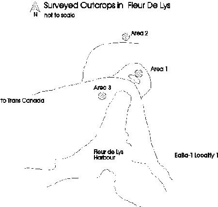
Figure 5. Surveyed Outcrops in Fleur de Lys
(i) Town of Fleur de Lys:
Three localities with visible rock outcrops were cursorily examined on August 5, 1997 in the town of Fleur de Lys (Figure 5). Area 1 is a small cliff-face located adjacent the small pond at the top of Fleur de Lys Harbour. This area was littered with recent debris, and there was evidence of recent burning. No pot scars or any evidence of prehistoric use were detected.
Area 2 is the large heavily-treed hill located about 500 metres northwest of the main road. The slope of this hill was heavily treed, making climbing extremely difficult. Some exposed rock were examined on the way to the top surfaces (none were soapstone). No evidence of Dorset quarry activities, or any other prehistoric occupation were found at these areas nor on the barren top of this hill, which otherwise offered a commanding view of the harbour.
Area 3 is an outcrop located immediately adjacent to a house on the south side of the main road and the west side of the harbour. No evidence of prehistoric use was noted.
(ii) EaBa-1 [Locality 2]:
This locality (Nagle 1982) of worked soapstone is situated just west of Quigley Road, off the main highway (Figure 6). While a few removal scars have previously been reported at the water’s edge and under the water at high tide at this locality, we believed that this area deserved another look. On August 19 we conducted a two hour walking survey of the hillside adjacent the known worked outcrop, but failed to discover any new carvings.
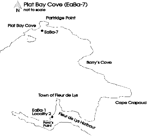
Figure 6. Plat Bay Cove (EaBa-7)
(iii) Plat Bay Cove (EaBa-7):
A local resident of Fleur de Lys reported finding a possible archaeological site just south of Partridge Point, in Plat Bay Cove (Figure 6). On August 7th we investigated this site by boat and located a stone feature which consisted of a number of boulders arranged roughly in a circular ring. During a previous visit, a few of the boulders on the northern side of this feature had been pulled back, exposing some flakes and ceramic material, but causing little other damage.
We excavated a 50 x 70 cm test pit in the area of the disturbance to a depth of about 40 cm. The top 30 cm consists of peat. This is underlain by a 4 to 5 cm thick ‘black’ organic cultural layer. Beneath this are 5 to 6 cm of small pebbles, and a mottled reddish-brown sandy-clay. The cultural material found within this feature consisted of gray and beige coloured fine-grained chert and quartz flakes; a core fragment; biface fragment; endblade fragment; a spall; and two microblade fragments. These materials were recovered in proximity to a burned area (possible hearth) which contained burnt fat and fire broken rock. Eleven pieces of fire broken rock and a sample of burnt fat were collected along with a total of 79 artifacts. Of these, seven historic ceramic pieces were also recovered from this structure.
Based upon the fragmentary artifactual remains from this test pit, the proximity to the shore, and the availability of marine resources (most notably harp seal), it is suspected that the cultural affiliation of this site is Dorset. Further excavation should confirm this. While it is possible to speculate on the relationship between Plat Bay Cove as a possible habitation site and the Fleur de Lys soapstone quarry, this cannot be substantiated without further investigation. The complete excavation of this feature is planned for the summer of 1998.
(iv) Ford’s Point:
On August 19 we investigated and test-pitted a small peninsula of land in Fleur de Lys Harbour known as Ford’s Point (Figure 6). Three shovel tests were conducted within a six metre radius of a few shallow depressions. All three had 10-14 cm of black topsoil, containing naturally-occurring quartz cobbles (just below the root level). Two modern “round” nails were found within this layer but were not collected. The subsoil consisted of a greenish-gray slate-like material. Bedrock was found at about 20 cm below the surface in all three units. No prehistoric material was detected.
(v) Coachman’s Cove:
While no archaeological sites have been reported in this community, it would appear that this area may have some potential for Dorset occupation, given the favorable physiography of the area for habitation. While both the northern and southern points on either side of Coachman’s Harbour looked encouraging from the topographic and aerial photographs, the northern coastline was very rugged, steep and inaccessible by boat. However, the southern point was accessible and on August 22 we conducted a three hour walking survey of the southern peninsula (Figure 7).

Figure 7. Coachman’s Cove (EaBa-7)
We started our survey along the south side of the road (just east of the wharf), and where the paved road ends. Two vegetable gardens located adjacent the road (on the south side) were examined, and a few ceramic fragments and a pipe stem fragment were noticed, but not collected. A 50 x 50 cm test pit was excavated between the two garden plots, at a location approximately nine metres north of the ridge that overlooks Baie Verte. The first 20 cm of this excavation contained ash and burnt wood. At 40 cm a greenish clay subsoil was reached. No artifacts were noted.
We continued our survey eastward along the “Cow Cove Trail” (which had been developed and marked as a walking trail, although the signs have since fallen down). We followed this trail to the eastern end of the peninsula, to a point that overlooked French Island. At about half a kilometre along the trail, we located a flat grassy meadow with a rocky beach which looked to have had some historic occupation based on the amount of recent debris, rectangular depressions and buried foundation walls. We excavated a single test pit at the western end of this meadow which was void of cultural material except a fragment of a “Wrestlemania IV” playing card (which was not collected). Beneath about 25 cm of brown/black topsoil, an orange colored soil layer was found and excavated to a depth of 45-50 cm. This area appears heavily disturbed by historic occupation, but merits further consideration and testing.
Finally, we viewed the shoreline of French Island with binoculars, but failed to notice any outwardly apparent signs of prehistoric occupation. In view of our lack of time a more intensive survey of Coachman’s Cove and French Island is planned for 1998.
(vi) Pigeon Island:
On August 23 we conducted a walking survey of Pigeon Island; Pardee Cove; Fleur de Lys Harbour Islands and the southern shore. On an overcast but calm morning we set off by boat to Pigeon Island. Pigeon Island is located about 3 km southwest of the mouth of Fleur de Lys Harbour. Accessibility to the island was limited by steep cliffs and impassable boulder beaches. Despite the limited access, we found a place to safely land the boat on the southwestern end of the island. We walked both the perimeter and the centre of the island to the highest point on the eastern edge. This is a very rugged, thin-soiled and sparsely vegetated island, consisting of mosses, ferns, scrub brush and stunted trees. We noted numerous caves and rock crevices and cursorily examined those which were easily accessible. We also noted numerous small water “holes” (presumably trapped rainwater) in the rock along the perimeter of the island. No cultural material was noted, nor was there any evidence for use of this island.
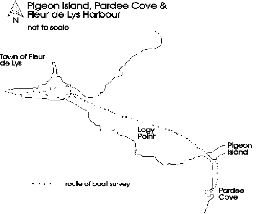
Figure 8. Pigeon Island, Pardee Cove and Fleur de Lys Harbour
(vii) Pardee Cove:
Upon completion of our survey of Pigeon Island, we continued on to Pardee Cove (about 0.5 km south of Pigeon Island) which contains a large (but soft) slate outcrop. This cove has a very narrow gravel beach and has evidence of some historic use. No signs of prehistoric use were evident based upon a half hour foot reconnaissance of this area.
(viii) Fleur de Lys Harbour:
After leaving Pardee Cove, we headed back into Fleur de Lys to investigate the small islands in the harbour. The smaller of the two islands (EaBa-3), reported by Thomson (1986) as a Dorset temporary camp was not visited. The larger of the two islands was cursorily examined, and much recent debris and historic structural remains were noted. No collections were made.
We briefly landed on the southern shore of the Fleur de Lys Harbour to inspect the “grassy” point located approximately 100 m east of EaBa-2 (historic settlement) which was the location of an overgrown garden. An informant mentioned that some coins from the 1800s were found when the garden was used. Unfortunately, this area was overgrown (about waist-high) at this late time of the year, which inhibited our examination during our very brief visit. Further testing of these areas is planned for the summer of 1998.
(ix) Miscellaneous Finds:
One informant from Fleur de Lys brought to our attention a small chert flared thumbnail scraper which he found beneath a fallen stump adjacent a house located directly across the road (south) of (EaBa-1) Locality 1. Stylistically, the large flared “ears” indicates that this specimen may be Groswater. No investigation of this possible site has yet been made.
Part 3 – Summary Conclusions
The initial field season of the Fleur de Lys Archaeology Project was most interesting from a number of perspectives. First, the excavations at Locality 1 yielded surprising preservation in the form of a waterlogged wood structure which may have been a scaffolding, ladder or some kind of retaining wall for the acquisition of soapstone from the quarry face. The recovery of this feature in the summer of 1998 will undoubtedly add to our understanding of the nature of the quarrying activities and the use of wood for construction at Fleur de Lys. Second, the discovery of a single habitation structure at Plat Bay Cove may represent the first of a number of Dorset dwellings at this location. In addition to the excavation of this structure, further testing of this area is planned. Third, the discovery of previously unknown preforms and preform removal scars in several loci finally indicate the full extent of the exposed quarry face.
Notes:
[1] This summary originally appeared in the Spring 1998 Canadian Archaeological Association Bulletin.
[2] Below the topsoil, the color of the soil in proximity to the quarry face is reddish-brown. This coloration is produced from the oxidization of the iron in the soapstone.
[3] Radiocarbon years before present (B.P.) where “present” = AD 1950.
References
Nagle, C.
1982 – “1981 Field Investigations at the Fleur de Lys Soapstone Quarry, Baie Verte, Newfoundland.” In, Archaeology in Newfoundland and Labrador 1981, eds. J.S. Thomson & C. Thomson. Annual Report No.2, Newfoundland Museum, Historic Resources Division, Department of Recreation and Youth, Government of Newfoundland and Labrador, pp. 102-129.
Stuiver, M. & P.J. Reimer
1993 – “University of Washington Quaternary Isotope Lab Radiocarbon Calibration Program Rev. 3.0.” Radiocarbon, 35, pp. 215-230.
Thomson, C.
1983 – “Proposal for the Management of the Dorset Soapstone Quarry at Fleur de Lys, Northern Baie Verte Peninsula, Newfoundland.” Unpublished Report prepared for Historic Resources Division, Department of Recreation and Youth, Government of Newfoundland and Labrador.
1984 – “A Summary of Four Contract Archaeology Projects in Newfoundland and Labrador.” In, Archaeology in Newfoundland and Labrador 1983, eds. J.S. Thomson & C. Thomson. Annual Report No.4, Newfoundland Museum, Historic Resources Division, Department of Recreation and Youth, Government of Newfoundland and Labrador, pp. 82-97.
1986 – “Investigations on the Baie Verte Peninsula, Newfoundland.” In, Archaeology in Newfoundland and Labrador 1985, eds. J.S. Thomson & C. Thomson. Annual Report No.6, Newfoundland Museum, Historic Resources Division, Department of Recreation and Youth, Government of Newfoundland and Labrador, pp. 196-217.
1987 – “Maritime Archaic and Middle Dorset Occupations at Fleur de Lys: Preliminary Results of 1986 Investigations on the Baie Verte Peninsula.” In, Archaeology in Newfoundland and Labrador 1986, eds. J.S. Thomson & C. Thomson. Annual Report No.7, Newfoundland Museum, Historic Resources Division, Department of Recreation and Youth, Government of Newfoundland and Labrador, pp. 250-259.
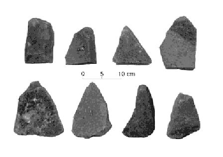
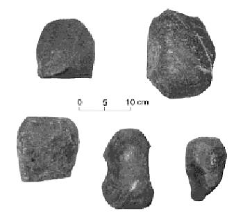
Appendix:
Quarrying Tools
Tabular Scrapers
Hammerstones
Non-Quarrying Tools
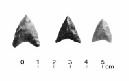
Endblades
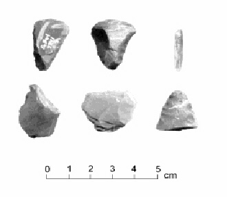
Top Row (l-r) scraper, endscaper, microblade Bottom Row (l-r) burin?, flake, biface
Soapstone Vessels
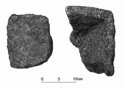
Large Soapstone Vessel Fragments
Small Unfinished Soapstone Vessels