
Archaeology in Newfoundland and Labrador 1997
Edited by K. Nelmes
Historic Resources Overview Assessments of Drill and Camp Sites in Northern Labrador, 1997
Gerald Penney
Introduction
Diamond drilling sites and camp sites on five mineral licence blocks were assessed between 23 June and 09 September 1997. The four assessments are reported in individual sections below.
Assessed sites lie within the geographic boundary formed by Kanairiktok River (south) and Okak Bay (north). Generally, drill sites were elevated and treeless, often at rocky outcrops showing signs of mineralization. Exploration base camp sites are located near lake shores, near river and brook estuaries or inflows, and usually in or near woods (Figure 1).
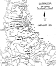
Figure 1. North-central Labrador.
Assessment Methodology
Topographic map interpretation, documentary research in the holdings of Gerald Penney Associates Limited, the Innu Nation, the Labrador Inuit Association, the Centre for Newfoundland Studies, the Archaeology Section of the Culture and Heritage Division, and other public and private archives, attempted to place study areas in geographic, historic, and environmental perspective. Consultations were held with the Provincial Resource Archaeologist, proponent companies’ field personnel, Innu and Inuit field assistants, and Innu and Inuit elders at Nain, Sheshatshit, and Davis Inlet.
Each specified location was foot-surveyed and, where practicable, a test pit was dug at the drill collar location. Each drill hole location area was assessed both by foot and during a helicopter flyover to determine the general lie of the land and to identify areas adjacent to drill locations requiring survey.
Camp sites, usually near ponds, lakes, and rivers (often occupying locations with conditions favourable for aboriginal encampment) were foot surveyed and test pits dug where camp platfoms, depots, etc. were proposed or established. Assessment of peripheral areas and shorelines focused on unforested areas.
Site Record Data
Three Kanairiktok River lakes (Pocketknife, Croteau, and Snegamook) have six prehistoric and 30 recent sites recorded (MacAleese 1992). Drainage areas (between the coast and Strange Lake) of Anaktalik Brook (Figure 2), Konrad Brook and Kogaluk River have 33 sites and 17 cairns recorded (Ryan and Biggin 1989). These show prehistoric and modern Innu and Inuit use. At Voisey’s Bay Stephen Loring found significant historic resources including the first prehistoric earthenware sherds found in Labrador (1992:279). Jacques Whitford Environment (1996) recorded 28 archaeological sites during an historic resources overview assessment of 15 remote exploration areas between Nain Bay and Snyder Bay in 1995.
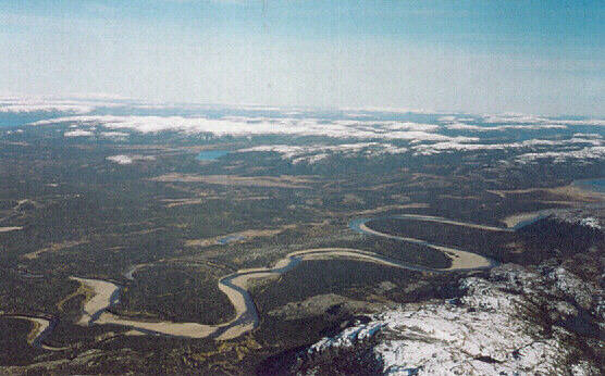
Figure 2. Anaktalik Brook near estuary; west view
Geography
The study areas are within the central and northern sections of the Labrador peninsula, the easternmost extent of the Canadian Shield. Its ancient crystalline schist and igneous rocks are compressed and greatly deformed (Gutsell 1949:74). The cold north Labrador Sea borders the east, the west boundary is the province of Quebec.
The area consists of two main physiographical regions. The largest, south of Nain, is a large undulating plateau, elevated in the southwest and sloping to lowland areas along the coast. Most of the plateau is at an elevation between 300 m and 450 m asl (ibid:74) with numerous, barren or semi-barren hills with very slight slopes, rarely exceeding 100 m. Intertwined among these hills are clusters of lakes, ponds, bogs, and rivers. River valleys are steep and rocky and in the higher regions of the plateau may be as much as 900 m deep (ibid:74). East of Nain is an extensive archipelago. Numerous fjords extend west as long, narrow, U-shaped valleys.
The second physiographical region, the mountains north of Nain, includes the Kaumajet Kiglapait, and Torngat Mountains. These, with numerous razor-edged ridges and sharp peaks (up to 1500 m asl) become more massive as one moves west from the coast. Remnants of alpine glaciation such as cirques and aretes decorate many peaks. The coastline is rugged with near-vertical cliffs 300 to 600 m high (Tanner 1947:65). The coast here has a few rugged islands (reaching heights of 825 m asl) separated by deep, narrow channels. Similar to the plateau region, fjords reach inland (as far as 48 km) every few kilometres.
Two Proposed Campsites for a Mineral Exploration Company
Study Areas:
Both proposed camp sites are on the tips of south facing points on the north shores of unnamed ponds.
Methodology:
On 23 June 1997 Gerald Penney and crew foot-surveyed two proposed camp sites. No historic resources were identified.
Results:
South Camp is in a medium dense stand of black spruce with a moss and lichen ground cover. A small brook draining an unnamed pond to the north flows along the west side of the proposed camp site.
North Camp is located on a moss and lichen covered barren. A few small black spruce grow to the west and north.
No historic resources were identified.
Six Proposed Diamond Drill Sites
Study Area:
Licence block 787M is on high ground (>500 ft asl) north of Voisey’s Bay. The study area is shown in Figure 1.
Methodology:
On 25 and 26 June 1997 Gerald Penney and crew foot-surveyed the 787M drill sites (Figures 3, 4).
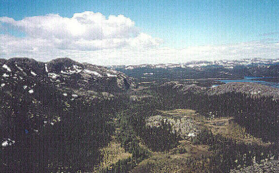
Figure 3. 787M Northern Drill Sites; Aerial West View.
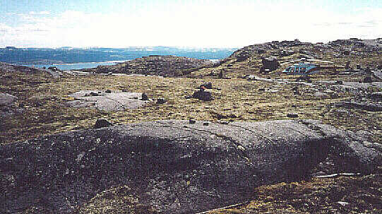
Figure 4. 787M Southern Drill Site.
Results:
Drill sites are located in stands of black spruce, with moss and lichen ground cover, and on exposed, barren knobs.
No historic resources were identified in the study areas.
Eleven Other Proposed Diamond Drill Sites
Study Area:
The 11 proposed drill sites are on elevated ground (300-400 ft asl) on the south slope of an unnamed ridge five kilometres north of Pants Lake.
Methodology:
On 31 August 1997 Gerald Penney and crew foot-surveyed 11 drill sites.
Results:
Drill sites are located in an exposed semi-barren area with moss, lichen, grass, and other low lying shrubs. Small sparse black spruce grow in sheltered areas.
No historic resources were identified in the study areas.
Yet Another Diamond Drill Site
Study Area:
Nukasusutok Island (24 km southeast of Nain; NTS 14/6) was the focus of much archaeological activity by William Fitzhugh (Brice-Bennett 1977:37) who reported three house pits. Garth Taylor (1974:16) documented Inuit habitation between 1773-1782 averaging 45 people, and visits by Moravian missionaries. Bryan Hood (1980:58-64) investigated a Maritime Archaic site (HcCh-7) and an Early Dorset site (HcCh-14) both near Wyatt Harbour, on the island’s south side. Hood conducted further investigations during 1992-93 as part of the Nain Maritime Archaic archaeological project. Penney (1996, 1997) conducted historic resources overview assessments of diamond drilling locations on South Aulatsivik Island (Black Island) and Niatak Island, both north of Nukasusutok Island.
The drill site is 160 m asl on the south side of a large hill near the centre of the island.
Methodology:
Prior to departure for Nain, consultations were held with Dr. William Fitzhugh, of the Smithsonian Institution, Washington, D.C., U.S.A. The office of the provincial resource archaeologist was consulted and the location of historic resources plotted on a 1:50,000 scale topographic sheet.
On 9 September 1997 Gerald Penney and a field assistant flew from Nain by helicopter to the elevated and barren drill site, already familiar to the helicopter pilot. The area was foot surveyed, walking two kilometres downhill to an unnamed cove on the western end of the island and Pumialuk Point was also surveyed.
Results:
Drilling operations were finished at the time of survey and the drill removed. Eight days (01 – 08 September) were spent drilling to a depth of 945 m.
No artifactual evidence of use prior to mineral exploration activity was found. NDT-1 includes a stone table/platform 14-15 m south of the drill hole, a fireplace five m west of the hole, a completed diamond drill bore hole, and associated artifacts (nails and pieces of metal) typical of a remote mineral exploration diamond drill site.
On the beach, south of Pumialuk Point, site HcCh-9 a tent ring (Figure 5) was located near a staging area used by NDT to access the drill site. About 700 m of Pumialuk Point was walked, and on the south side 11 features were preliminarily identified. These include at least six other tent rings, two graves, one sod house and one cache. Features seem confined to the south side of the point. Ken Reynolds, of the Culture and Heritage Division (CHD), as a member of a government assessment team re-visited the drill site on 22 October 1997 and further photographed HcCh-9. It was determined to have been wrongly placed on CHD maps. Its position was corrected and a new Borden Number (HcCi-8) issued.
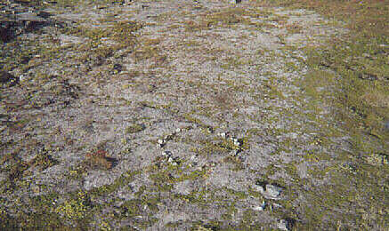
Figure 5. Tent Ring; Aerial Northeast View.
Recommendations
The island’s isolation, its numerous archaeological sites, and apparent negative drill results will likely prevent further mineral exploration activity an Nukasusutok Island. The immediate area was designated a heritage site as an example of modern mineral exploration.
Further archaeological research is not required.
References
Brice-Bennett, Carol (ed.)
1973 – Our Footsteps are Everywhere: Inuit Land Use and Occupancy in Labrador. Labrador Inuit Association. Nain.
Gutsell, B.V.
1949 – An Introduction to the Geography of Newfoundland. Canada Information Series No. 1. Department of Mines and Resources Canada. Ottawa.
Henriksen, Georg
n.d. – “Land Use and Occupancy among the Naskapis of Davis Inlet.” Report on file at Innu Nation offices. Sheshatshit.
Hood, Bryan
1980 – “Miscellaneous Archaeological Investigations along the North-central Labrador coast: 1980,” in, Archaeology in Newfoundland & Labrador 1980. Department of Culture, Recreation and Youth, St. John’s.
Jacques Whitford Environment
1996 – “An Overview Assessment of Fifteen Remote Exploration Areas between Nain Bay and Snyder Bay, Ladrador.” Draft report on file at Culture and Heritage Division, Department of Tourism, Culture and Recreation, Government of Newfoundland and Labrador. St. John’s.
Loring, Stephen
1992 – Princes and Princesses of Ragged Fame: Innu Archaeology and Ethnohistory in Labrador. Ph.D. Thesis, Department of Anthropology, University of Massachusetts. Boston.
MacAleese, Kevin
1992 – “Kanairiktot River Survey: Preliminary Report.” Report on file with the Culture and Heritage Division, Department of Tourism, Culture and Recreation, Government of Newfoundland and Labrador. St. John’s.
Ryan, Bruce and Scott Biggin
1989 – “Kogaluk River Archaeological Reconnaissance Survey, Labrador, 1987: Western Extreme and Surrounding Area.” Report on file with the Culture and Heritage Division, Department of Tourism, Culture and Recreation, Government of Newfoundland and Labrador. St. John’s.
Tanner, Vaino
1947 – Outline of the Geography, Life & Customs of Newfoundland-Labrador (The Eastern Part of the Labrador Peninsula). The University Press. Cambridge.
Taylor, Garth
1974 – Labrador Eskimo Settlements of the Early Contact Period. Publications in Ethnology No. 9, National Museum of Canada. Ottawa.