
Archaeology in Newfoundland and Labrador 1997
Edited by K. Nelmes
Historic Resources Overview Assessment: Ten Commercial Harvesting Areas, Resource Management District 1 (Avalon Peninsula)
Gerald Penney
Introduction
The Department of Forest Resources & Agrifoods identified forty-six commercial harvesting areas in resource management district 1 (Avalon Peninsula). Gerald Penney Associates Limited was contracted to conduct an historic resource overview assessment. Ten study areas in ten harvesting areas were selected based on a preliminary assessment of their historic resources potential. Fieldwork was carried out between 14 July 1997 and 16 September 1997.
This report presents assessment results organized by area. A brief settlement and exploration history appears in an Appendix.
Study Area
Resource management district 1 consists of the Avalon Peninsula and the isthmus connecting it to the main part of the Island (Figure 1).
Figure 1. Study Area.
Methodology
Prior to fieldwork, topographic map and aerial photography interpretation, consultations with the Culture and Heritage Division, along with documentary research, were conducted to determine areas with historic resource potential.
Fieldwork
Sections of commercial harvesting areas considered to have historic resources potential were accessed by vehicle and/or foot. The areas were foot-surveyed and photographed, and test pits were dug.
Geography
The Avalon Peninsula and the isthmus connecting it to rest of the island form the southeast part of the Island of Newfoundland. The Peninsula is about 9570 km2. The isthmus is approximately 40 km long (N-S), and 3-5 km wide at its narrowest (Seary 1971:18).
The Avalon’s 1263 km long coastline (Seary 1971:18) includes the southern and eastern shores of Trinity Bay, the whole of Conception Bay, Trepassey Bay, St. Mary’s Bay and the east coast of Placentia Bay. The coast is rugged with steep escarpments, broken with hundreds of small bays and coves. A small river or brook empties into almost every cove.
Inland, the land is a hummocky rolling plateau, 75-250 m above sea level (South 1983:138) with isolated hills rising above the general level intertwined with numerous ponds and streams (totalling 14% of the total surface). Bogs and fens are common.
Forestry
About 38% (3637 km2) of the Avalon Peninsula is classed with a greater than 5% forest cover. About 43% of this was not considered commercial in 1956. These extensive areas were either burned so severely the soil lacked the capacity to produce merchantable trees, or was so exposed and poorly drained that tree growth was inhibited. Large forests were on inland plateaus at elevations above 500 feet (Wilton 1956:8).
The main productive forests were in a triangle between the bays of Trinity, Conception, and St. Mary’s. Other extensive areas were in sheltered bays and inlets. About 22% (2100 km2) of productive forest was small shrubs and seedlings, with the remainder mainly pulpwood and firewood. Large saw timber did not exist and small saw timber, 4 to 10 inches, was either privately owned or restricted to remote areas (ibid:9).
Settlement lumbering was the original forest industry; John Guy built the first recorded sawmill in North America in 1610. Domestic harvesting was localized until the nineteenth century advent of a new sawmill industry in the pine forests of central Newfoundland. After the pine was cut, the logging industry turned to pulpwood. During the 1920s, sawmilling made a comeback replacing the steam driven machinery of the pine era with water-powered mills (Smallwood 1984:303).
Small timber, and its scarcity, restrict Avalon harvesting to small scale lumbering and firewood. Commercial operators are generally localized, family operated, and small scale, rarely using industrial techniques. Avalon commercial operations are “large scale domestic.”
A number of forest fires have been recorded for the Avalon, leaving only very small areas of natural, undisturbed forest. In 1862, fires burned the St. John’s area, including Topsail, Freshwater, Bay Bulls Road, and Petty Harbour Road. In 1867, eleven fires burned areas near Freshwater Bay. Forest fires burned along the railway line on the isthmus, Placentia Junction, and between Brigus and Shoal Harbour in 1892 and 1899. In 1934, large areas in Trinity and Bonavista Bays were burned. In 1951 fires burned areas near Grates Cove, Branch, Witless Bay, Caplin Cove, Shearston, Western Bay, Cape Broyle, Colliers, Broad Cove, Ruby Line, Hearts Content, S.E. Placentia, Donovans, Witless Bay Line, and Colinet Road; there were six outbreaks between Cape Broyle and Cape Race (Wilton and Evans 1974:112).
Harvesting
Commercial harvesting activity on the Avalon Peninsula differs from other areas of the province. Timber transport using snowmobiles, or all terrain vehicles and sleds causes less ground disturbance and destruction than skidders and trucks. Forest access roads are not extensive. Most saw log operators practice selective harvesting (highgrading). Where rare stands of large saw logs occur, clear cutting is practiced. Pulp and firewood harvesting on the Avalon use clear cutting; however, cutovers are not permitted to exceed five hectares.
Haricott, St. Mary’s Bay, Commercial Harvesting Area
Study Area:
The area in question here is the southern section of the commercial harvesting area, at approximately the east sides of Harricott Bay and Harricott Pond. The area lies on the western slope of the height of land between Harricott Bay and Salmonier Arm of St. Mary’s Bay.
Methodology:
We foot-surveyed and photographed the east shore of Harricott Pond and the east shore of Harricott Bay. Two test pits were dug on the south side of the bar separating Harricott Pond and Harricott Bay. Two test pits were also dug along the east shore of Harricott Bay.
Results:
The shore in this area consists of sand- and gravel-dominated beaches backed in some areas by a small pond or gully and forest (Figure 2). In several areas the land rises abruptly away from the shore. Four test pits dug were in disturbed thin topsoil over sterile sand and beach gravel. No historic resources were identified.
Future activity will continue to access this forest in winter from the shoreline or across the top of the ridge from the east. The area has low historic resource potential.

Figure 2. West Side of Harricott Commercial Harvesting Area; East View.
Beaver Pond, Placentia Bay, Commercial Harvesting Area
Study Area:
The study area encompasses the southeast edge of the Beaver Pond commercial harvesting area at approximately the confluence of Southeast River and Beaver Pond Brook, and is located on the steep southeast slope of Southeast River. This section of the river, including Beaver Pond Brook, flows in a very deep, V-shaped valley with near-vertical cliffs and numerous rapids and falls.
Methodology:
The study area was viewed and studied from the highway.
Results:
Forest cover grows from the northwest shore of the river for about 500 m (to about 100 m asl) where bog and wet terrain begins. The area is considered to have low historic resource potential. Log cutting along the upper edge of this forested area would have to be accessed from the ridge; access from the river is impossible.
Branch Pond, Placentia Bay, Commercial Harvesting Area
Study Area:
The study area under examination here encompasses the southeast edge of the commercial harvesting area where it approximates the west side of Branch Pond about two kilometres north of Placentia Junction. Forest cover rises away from the west side of Branch Pond for about 200 m (about 50 m along the pond) where boggy, wet terrain begins.
Methodology:
Branch Pond was examined and photographed.
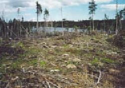
Figure 3. Cutover on East Side of Branch Pond; West View.
Results:
Limited forestry has been conducted here, which is evident by small cutovers (Figure 3). The east side of the pond is dominated by boggy wet terrain. The area has low historic resource potential.
Second Island Pond, Placentia Bay, Commercial Harvesting Areas
Study Area:
The area comprises the east and west edges of the commercial harvesting areas where they approximate the southern shore of Second Island Pond about nine kilometres northeast of Long Harbour, Placentia Bay.
Access:
We travelled southeast on an abandoned rail bed by vehicle from Long Harbour Road Crossing for about five kilometres, then walked along an all terrain vehicle path through cutovers and bogs for about one kilometre before reaching the study area.
Methodology:
We studied and photographed Second Island Pond.
Results:
Apart from a few hardy spruce trees, wet terrain inhibits tree growth within 500 m of the southeast shore. The area is thought to have low historic resource potential.
Commercial harvesting here is small scale, using all terrain vehicles and snowmobiles. Saw logs are small, and a large proportion of cut logs are used for firewood. There are some small cutovers in the area which show signs of highgrading.
Little Gut Pond, Resource Access Road
Study Area:
The study area is situated on the southwest end of the proposed resource access road in proximity to the north shore of Little Gut Pond about six kilometres north of Placentia Junction. The pond is surrounded by a boggy unforested area.
Access:
We travelled Spread Eagle Peak resource access road by vehicle for about four kilometres. We then walked along an all terrain vehicle trail (Figure 4) through cutovers and bogs for about one kilometre to the study area.
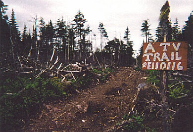
Figure 4. ATV Trail Leading from Forest Access Road to Little Gut Pond.
Methodology:
We foot-surveyed and photographed Little Gut Pond shoreline near the proposed forest access road boundary.
Results:
Little Gut Pond has a cobble bottom, lacks surface algae and appears lifeless. We consider the area to have low historic resource potential.
Black Duck Pond, Trinity Bay, Commercial Harvesting Area
Study Area:
The Study Area is located in proximity to the east shore of Black Duck Pond about three kilometres northeast of Heart’s Desire. Black Duck Pond is located in a southwest, northeast oriented valley.
Access:
We travelled an access road at the end of Martin Rowes Pond Road by vehicle for about 500 m. We then walked along an all terrain vehicle path over bogs and cutovers for about two kilometres to reach the study area.
Methodology:
We viewed and photographed Black Duck Pond.
Results:
The east side of the pond is backed by marshy wet terrain which inhibits forest growth within 500 m of the shoreline. An existing forest road from Heart’s Content accesses the northern end of the harvesting area. The area is considered to have low historic resource potential.
Broad Cove Pond, Commercial Harvesting Area
Study Area:
The study area is located in proximity to the east shore of Broad Cove Pond and the river emptying Broad Cove Pond. The area is in a heavily wooded inaccessible area on the steep west slope of a northwest-southeast oriented valley.
Access:
We travelled Broad Cove Pond access road for about one kilometre, then walked about 300 m through scrub forest before viewing the study area from a hill.
Methodology:
The study area was examined and photographed.
Results:
Future access to this forest will be from the north. An existing road system now leads to the northern side of the forest from the Conception Bay side of New Harbour Barrens.
The area is considered to have low historic resource potential.
Hennesseys Pond, Commercial Harvesting Area
Study Area:
The study area is in the low land south of Dog Hills around Jakes Gully, Hennesseys Pond, and encompasses other unnamed ponds about eight kilometres southeast of Foxtrap, Conception Bay. The majority of the study area consists of cattle pasture and access roads.
Access:
The crew travelled south on Dog Hills access road by vehicle for about two kilometres, then walked along the access road through the Dog Hill community pastures for about two kilometres to view the study area from a small hill.
Methodology:
The study area was photographed and examined.
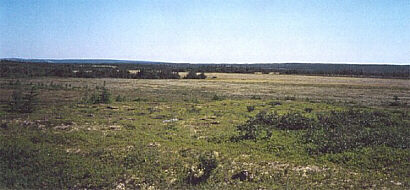
Figure 5. West View across Pasture to Commercial Harvesting Area.
Results:
Forest cover is limited to the north end of the designated commercial harvesting area, in an area divided by an electrical transmission line (Figure 5). The area is considered to have low historic resource potential.
Witless Bay Country Pond, Commercial Harvesting Area
Study Area:
The study area is the commercial harvesting area located on the southern edge of the north shore of Witless Bay Country Pond, about six kilometres northwest of Witless Bay. It is located in a heavily wooded, inaccessible area on the steep south slope of a 213 m asl high hill.
Access:
The crew travelled Country Pond road by vehicle for about three kilometres to reach a dam at the south end of Witless Bay Country Pond, then walked around the north shore of the pond to view and photograph the study area. We then travelled northwest on Witless Bay access road for another 12 kilometres by vehicle to view the north edge of the Witless Bay commercial harvesting area.
Methodology:
The crew studied and photographed the study area.
Results:
Witless Bay Country Pond was dammed for hydro development after 1951, raising the water above its natural level. The natural beach is submerged by about 5 m of water. Dam construction and associated hydro developments at Pierre’s Brook, Tors Cove, and Mobile made the area easily accessible. The intersection of the new forest access road and the road to the dam is substantially modified and occupied by vehicle campers during the summer. A 1951 map shows numerous secondary access trails and paths. The study area is considered to have low historic resource potential.
Snows Ridge, Commercial Harvesting Area
Study Area:
The study area is a 0.5 km area of very small growth forest east of Snows Pond, about five kilometres west of Makinsons. The study area is located on the steep west slope of Snows Ridge about 406 m asl.
Access:
The crew travelled southwest on North River access road by vehicle for about 6 kilometres to reach the end of the navigable road, then walked along an old trail up the west slope of Snows Ridge (Figure 6). We then walked northeast along a blueberry development area cutline.
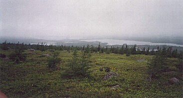
Figure 6. Snows Ridge; South View to Snows Pond.
Methodology:
The crew viewed, photographed, and foot-surveyed the study area.
Results:
Forest cover is patchy and the area does not appear to have commerical value. A posted blueberry development area forms the western side of the commercial harvesting area. Cutting in the harvesting area occurs in winter by crossing Snows Pond on snowmobile. Little valuable timber remains in the area. The area is considered to have low historical resource potential.
Recommendations
Loggers should be advised on the recognition of chance historic resource finds and how to report them to the Culture and Heritage Division of the Department of Tourism, Culture and Recreation. Planned road corridors, dam sites, or other construction areas should be assessed to Stage 1 Historic Resources Overview Assessment standards.
Appendix:
Brief Settlement and Exploration History
Settlement histories of Avalon Peninsula communities near study areas are summarized here:
- Spread Eagle, a fishing community, was settled before 1870 and resettled around 1967.
- Harricott was settled before 1836. Throughout the 19th century Harricott residents earned their livelihood through fishing, subsistence farming, and after 1900, through sawmilling.
- Foxtrap, between Long Pond and Kelligrews, was settled before 1845. Until the 1950’s Foxtrap was primarily a fishing-farming settlement with sawmilling and mining at Bell Island.
- Mahers, a railway siding between Brigus Junction and Ocean Pond, was permanently settled by 1950. Most residents were involved with the railway or sawmills. It is now a cottage area.
- Heart’s Desire, on the east shore of Trinity Bay, seven kilometres north of Heart’s Delight, was settled by 1790. Heart’s Desire depended on fishing, farming, and lumbering.
- Placentia Junction, on the railway line 12 kilometres southwest of Whitbourne, settled by railway employees after 1890, is now a cottage area.
- Villa Marie, a railway siding where the Placentia spur crossed Placentia to Fox Harbour road, was settled after 1890. In 1970 it was the site of a silica mine.
Exploration
The first recorded exploration of the Avalon Peninsula was by Henry Crout, a member of John Guy’s colonial enterprise. Crout went overland from Cupids to Hopeall in 1612, explored by boat the whole coastline from Cupids to Dildo and into Mosquito Cove in Bull Arm, the isthmus between Trinity Bay and Placentia Bay, the interior south of Dildo Pond and the barrens between Harbour Grace and New Harbour (Gilbert 1990).
Large portions of the Avalon Penisula interior were officially explored by Frederick R. Page and James P. Howley (Seary 1971). Neither explored near the study areas.
Page surveyed a proposed road route between Holyrood, Conception Bay, and Ship Harbour, Placentia Bay, with the assistance of Micmac guides. He went along Hodgewater River from Level Pond, near Cupids, to Ocean Pond, and west past Spread Eagle Peak to Coles Pond, then southwest past Long Harbour to Ship Harbour. He provides toponyms since fallen out of use and describes the geography and geology of the areas through which he passed. He makes reference to Indian wigwam sites along Hodgewater River and describes his camping locations. Modern woodsmen from the area still use “Page’s Line” as a convenient marker.
Howley, as part of the 1872 Geological Survey of Newfoundland, traced Page’s route to Ocean Pond, continued south along Ocean Pond to Round Pond West, Long Pond, and Bethunes Pond (at Whitbourne) to “The Forks” of Hodgewater River and Rocky River and on to St. Mary’s Bay. He recorded his camp site locations and Micmac toponymy.
References
Gilbert, William
1990 – “Divers Places: The Beothuk Indians and John Guy’s voyage into Trinity Bay in 1612.” Newfoundland Studies 6(2):147-167.
Seary, E.R.
1971 – Place Names of the Avalon Peninsula. University of Toronto Press: Toronto.
Smallwood, J.R. et al.
1984 – Encyclopedia of Newfoundland and Labrador. Vol. II. Institute of Social and Economic Research, Memorial University of Newfoundland: St. John’s.
Wilton, W.C.
1956 – “Forest Resources of the Avalon Peninsula, Newfoundland.” Department of Northern Affairs and Natural Resources. Forestry Branch, Forest Research Division. Technical Note No. 50.
Wilton, W.C. and C.H Evans
1974 – “Newfoundland Forest Fire History.” Newfoundland Forest Research Centre. Information Report N-X-116.