
Archaeology in Newfoundland and Labrador 1997
Edited by K. Nelmes
Historic Resources Overview Assessment: Stagg Pond Cottage Development Area
Gerald Penney
Introduction
The Department of Government Services and Lands, Government of Newfoundland and Labrador, proposes to develop a 15 lot cottage development area and a one kilometre access road on the south side of Stagg Pond about five kilometres west of Glovertown, Bonavista Bay. Gerald Penney Associates Limited was contracted to conduct an historical resources overview assessment of the cottage development area and the access road.
Fieldwork was carried out on 22 September 1997.
Study Area
Stagg Pond is north of, and flows into Maccles Lake (Figure 1). Its eastern end is within 0.5 km of an abandoned railway bed. Maccles Lake cottages are accessed from Alexander Bay station via roads and the abandoned railway track.
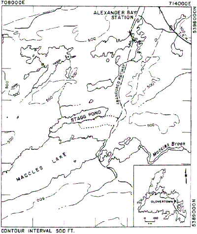
Figure 1. Study Area (dotted line).
Geography
The south side of Stagg Pond is hummocky and gently rolling landscape. The land slopes towards the southeast with a maximum elevation of about 220 m above sea level. Draining into Maccles Lake, Stagg Pond is one of three large lakes in the area including Gambo Pond (north) and Terra Nova Lake (south). A number of small ponds (Rocky Pond and Chain Pond also drain to Maccles Lake; Gull Pond drains to Northwest Arm of Alexander Bay) define an area of heavy forest subjected to extensive cutting for more than a century (Smallwood 1984:541).
Significance
J.P. Howley reports evidence in 1869 of earlier French settlement in the Glovertown area. He reported a number of small clay pipes “of peculiar pattern” uncovered near Bloody Bay River and an associated find, an ink-bottle-shaped clay object. The object is inscribed on opposite sides with a “French” W and a heart with a dent in its center and a stroke drawn towards the dent. Howley concluded the mark is intended to portray the Sacred Heart. Another side has the date 1687 inscribed (Kirwin et al. 1997:52).
An archaeological survey of the shoreline of Gambo Pond and Terra Nova Lake to the north and south of the study area (Schwarz 1987) found 18 prehistoric sites, many represented by single artifact finds. An historic resources overview assessment of Butts Pond (Stopp 1991), 20 km north of Stagg Pond, for cottage development, reported negative results.
Settlement History
Settlement histories of communities near the study area, taken from the Encyclopedia of Newfoundland and Labrador, are summarized here:
Glovertown (including Alexander Bay, Rosedale, Angle Brook, Norton Cove, Glovertown North, Central, and South) was settled by 1840 with an economic emphasis on salmon in Terra Nova River and lumber in the hinterland. Maccles Brook flows into Terra Nova River at the Trans Canada Highway crossing at the E.S. Spencer Bridge. It is small and twisting with many rapids and falls, and, according to one informant interviewed for this study, is unsuited for travel or fishing.
Terra Nova was settled before 1935, and throughout the area, people were employed in some aspect of the forest industry. Today the village of Terra Nova is made up of seasonal residences. Most year round inhabitants are employed in poultry, farming or tourism.
Traytown, settled before 1884 with a major emphasis on lumbering, today survives on tourism.
Methodology
Prior to fieldwork, topographic map and aerial photography interpretation was conducted; consultations with the Archaeology Office of the Culture and Heritage Division and local residents, along with documentary research, were conducted to determine areas with historic resource potential.
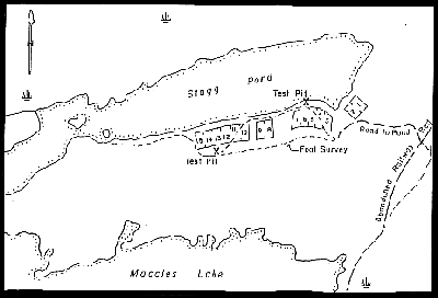
Figure 2. Stagg Pond Cottage Development Area.
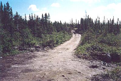
Figure 3. Existing Access Road to Proposed Cottage Development Area.
Results
The east section of the proposed cottage development area is heavily disturbed and already contains a temporary access road (Figure 3) to two cottage lots (numbers 1 and 3 of Figure 2). Evidenced by a number of deteriorating burnt stumps and small, sparse, black spruce and shrub heathlands, the area appears burnt over in the recent past (Figure 4). Domestic forest activity, evident by a few isolated stumps, has occurred in the past (Figure 5). The north side of Stagg Pond is used extensively by big and small game hunters to access the more barren country to the west. The cottage development area on the south side of Stagg Pond is also used or interior access but as it is boggy, its use is less frequent.
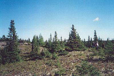
Figure 4. Vegetation cover typical of cottage area. On the bottom left is the proposed road.
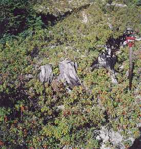
Figure 5. Deteriorating stump near Stagg Pond; common throughout the study area.
The shore is sharply defined with a vertical rocky embankment about 1 m high topped with alder and shrubs (Figure 6). No natural beaches suitable for camping exist along the area of the proposed cabin lots.
A test pit dug in a section of heath land on the shore of Stagg Pond, showed a shallow layer of black organic material underlaid by sterile gravel. A second test pit on the highest piece of land along the proposed access road, was in moss underlaid by brown sterile gravel. No historic resources were identified.
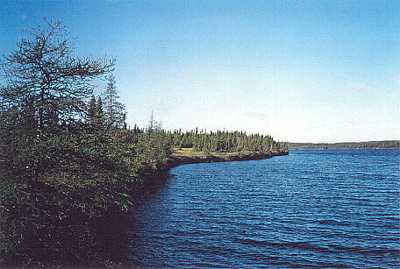
Figure 6. South shore of Stagg Pond; west view.
Conclusion
The proposed cottage development area is considered of low historic resource potential. No further action is recommended.
References
Encyclopedia of Newfoundland and Labrador.
1981-93 – Newfoundland Book Publishers (1967) Limited (Vols. 1 and 2) and Joseph R. Smallwood Heritage Foundation, Inc. (Vol. 4), St. John’s.
Kirwin, William J., G.M. Story and Patrick A. O’Flaherty (eds.)
1997 – Reminiscences of James P. Howley: Selected Years. The Champlain Society, Toronto.
Schwarz, Fred
1987 – “Survey of Gambo Pond and Terra Nova Lake.” Unpublished manuscript on file, Culture and Heritage Division, Department of Tourism, Culture and Recreation, St. John’s.
Stopp, M.P.
1991 – “Cultural Resource Assessment of Butts Pond-Middle Brook Remote Site Development.” Unpublished manuscript on file, Culture and Heritage Division, Department of Tourism, Culture and Recreation, St. John’s.