
Archaeology in Newfoundland and Labrador 1997
Edited by K. Nelmes
Archaeological Excavations at Parke’s Beach, 1997
David Reader
Introduction
For three weeks in June of 1997 the author and three field assistants returned to the Parke’s Beach site (DgBm-1) in the Bay of Islands, Newfoundland (Figure 1), to continue with archaeological excavations first begun when the site was discovered in 1995 (see Reader 1996). The 1997 excavations had two primary goals: 1) to conclude excavations of the Groswater Palaeoeskimo house feature labelled as Groswater House 1, Feature 1, as a continuation from the 1996 excavations at that house feature; and 2) to excavate a portion of a Beothuk component at the extreme southeast end of the site, which was first detected and test-pitted in 1996 (Reader 1997:10-12).
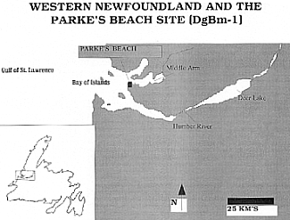
Figure 1. : Western Newfoundland and the Parke’s Beach Site
The excavations at Groswater House 1 completed excavation of the feature and provided additional data on the house form, associated features, artifacts, and preserved faunal material which was formally analyzed. In the Beothuk component, some 75 metres grid south of Groswater House 1, excavation confirmed a suspicion of the existence of a Beothuk house feature (labelled Beothuk House 1) and associated material culture, including lithic, faunal, and European iron from a mostly peat-sealed context. Rather unexpected was the presence of a Dorset Palaeoeskimo component with excellent faunal preservation, deeply sealed by beach rock below the Beothuk component. Although the Dorset material was not a prime research interest for the author’s doctoral research at the site, the noted Dorset component below the Beothuk component did suggest that a much larger, expansive Dorset component may exist at the site than previously noted (see Reader 1997:9-10).
Parke’s Beach, also known locally as ‘Sammy’s Beach,’ is located on a 1.7-2.5 m a.s.l. (above sea level) narrow beach terrace which stretches for approximately 350 m along the base of a steeply rising hill near the southwestern tip of the south shore of Middle Arm, Bay of Islands. The substratum of the beach is formed of limestone pebbles and small slabs of limestone and shale, clearly visible along the storm beach front. Vegetation on the beach is dominated by various types of grasses and is sparsely strewn with stunted alders which grow closer toward the base of the hill, while the steep hillside itself is heavily wooded with white spruce and white birch. One permanent fresh water source, a small stream running down the hillside at the extreme southeast end of the beach, was noted in the immediate vicinity.
Excavations at Groswater Palaeoeskimo House 1
Formal archaeological excavation of the Groswater Palaeoeskimo component at Parke’s Beach was conducted by the author in 1996, and again in June, 1997. This intensively investigated Groswater house feature was labelled Groswater House 1 and Feature 1 (Reader 1997). A test trench was excavated in 1995 at Groswater House 2, while several other Groswater houses were test-pitted. In 1997 the eastern portion of the Groswater House 1 feature was excavated, along with a trench along the northwest perimeter of the house, and a re-excavation of six square metres in the southwestern interior and perimeter of the house. Overall, the 1997 excavation was designed to trace the discard perimeter of the house feature and to provide more specific data on the areal layout of the house.
A total of 14 m2 was excavated in 1997, bringing the total area excavated associated with the house feature to 27.5 m2. An additional 286 lithic artifacts were recovered in 1997 bringing the overall total to 589 artifacts, which continued to reflect a relatively dense artifact cluster associated with the house, averaging greater than 21 artifacts per square metre. Two additional features were noted in the eastern portion of the house, one being a second recognizable post mould, and most significantly, a bone midden feature on the northeast perimeter of the house which allowed for a formal analysis of the faunal elements. What is perceived to be a possible entrance area to the house was also recorded in the northeast perimeter area.
Stratigraphy:
Excavation followed both cultural and natural stratigraphic levels, consisting of a surface sod layer, then lower cultural Level 1 and cultural Level 2 (both associated with the Groswater occupations of the house feature), and below these levels, natural Level 3 beach gravel at which point cultural material was not evident. Both cultural levels, 1 and 2, extended horizontally throughout the house feature and external to it. In total, the vertical extent of these cultural levels was from 4-20 cm in depth, except in the eastern midden area where Level 2 was as deep as 40 cm. Level 1 matrix consisted of loose black soil, slightly greasy in texture, and small limestone pebbles. The maximum thickness of Level 1 ranged from 2-10 cm. Within the house, but away from the house discard perimeter, lithic tools and debitage were more abundant in this level than in Level 2. However, within the context of the discard perimeter lithic material and faunal bone was most abundant in Level 2. Level 2 consisted of a layer of fire-cracked and heated limestone, granitic and quartzite slabs and cobbles and a more dense concentration of unmodified limestone slabs and shale with little soil matrix.
Areal Description of Groswater House 1:
The completion of 1997 excavations at Groswater House 1 confirmed that the house feature was roughly oval in shape, as discerned by the placement of the discard perimeter and two recognizable post holes. The maximum exterior dimensions of the dwelling were confirmed to be 6 m west/east x 5 m north/south. The maximum interior dimensions of the house measured 4.5 m west/east x 4.5 m north/south.
It seems more than coincidental that the greatest concentrations of perimeter refuse occurred in three areas along the north and north-western portions of the house perimeter which would have been subject to regular strong onshore northwesterly winds. To posit that relatively more cultural debris and beach gravel were deliberately piled up in these areas by house occupants to help serve as hold down areas for the tent structure would not be without some merit.
Two post moulds were discerned within the discard perimeter, as discussed below, one (Feature 3) in the northwest portion and another (Feature 12) at the northeastern house perimeter, just east of the house entrance. Given the placement of the post holes, they are assumed to be associated with the construction of the tent support poles. The lone entranceway of the house was discerned by a distinct gap approximately 50 cm wide in the peripheral debris deposits at the northeast perimeter of the house. The entrance faced the beach to the northeast.
Features Noted in 1997:
As noted above, two additional features were recorded during 1997 excavations. These consisted of post mould Feature 8 and faunal bone midden Feature 16. Apart from the house itself labelled as Feature 1, this brought the total number of recognized features associated with the house to five (see Reader 1997).
Feature 8, Post Mould.
This post mould was well defined and was situated within the discard perimeter on the northeastern house boundary approximately 50 cm southeast of the entranceway. The maximum horizontal diameter of the post mould was 10 cm at the top, and 4.5 cm at its base. It measured 23 cm in depth, at first seeming unusually deep for such a post mould. However, the deep vertical outline of the post mould is likely attributable to the build-up of cultural debris around the post after the construction of the house and during its occupation. This evidence is highly suggestive that the post mould was associated with the construction of the House 1 dwelling. No other post moulds were preserved or discernible. A portion of the post itself, a round pole section approximately 10 cm long was found remarkably well preserved with the post hole.
Feature 16, Faunal Midden.
The Feature 16 faunal bone midden was situated within, and predominantly under, the northeastern discard perimeter of the house feature. Only two square metres of the feature were excavated in 1997, but it was evident that the dense concentration of overwhelmingly unburned, and well preserved faunal bone extended from the middle of the discard perimeter/wall to the northeast immediately outside the house boundary where most of the bone was located. The bone deposit was thinly covered with fire-cracked and unmodified beach rocks. Large primary stage lithic reduction flakes were associated with the midden, as were scattered flecks of charcoal. Based on the excavated portion of the midden, and viewing its continuation outside the house feature in the excavated units’ profiles, the total size of the midden is estimated to be in the area of 6 m2. Many small fragments of calcined faunal bone were within the midden and, along with the charcoal in the midden, suggest secondary deposition of hearth related debris. The Feature 8 post mould was associated with the eastern extent of the midden. Artifacts found within the midden included two adjoining medial fragments of a bone needle, two diagnostic Groswater endblades, five scrapers, a whetstone, two bifaces and a retouched flake.
Lithic Artifacts and Materials:
Lithic artifacts and materials recovered in 1997 attributable to the Groswater Palaeoeskimo component at Groswater House 1 are discussed within the overall context of the house feature and lithic artifacts and materials from the previous 1996 excavations of the house feature. From an area of 27.5 m2 excavated at House 1, a total of 588 lithic artifacts (Table 1) were recovered in addition to portions of a bone needle and four other carved bone fragments. The density of lithic artifacts at House 1, based on the near total excavation of the dwelling, is approximately 21.5 per square metre with the most dense artifact concentrations from areas within the discard perimeter. The artifact frequencies from House 1 reflect an intense focus on (presumably) hide processing and to some degree, wood and bone working, as scrapers represent an uncharacteristically high frequency (n=134) of artifacts at House 1, relative to other Groswater sites. At 22.75%, scrapers here stand out over scraper frequencies at other regional Groswater sites/houses, which range between 5.35% to 8.92% frequency at Postville (Loring and Cox 1986:72-76), Blanc-Sablon (Pintal 1994:157), Phillip’s Garden East and Phillip’s Garden West (Renouf 1994:167). Processing of food or other raw materials at Parke’s Beach House 1 is also reflected in the relatively high proportion of modified (retouched and utilized) chert flakes. The Blanc-Sablon site also features a high frequency of modified flakes (Pintal 1994:157), but the sample size is comparatively small and may or may not be biased for this reason. Frequencies of artifacts reflecting direct hunting technology, namely endblades and side blades, are roughly on par with other such frequencies from regional Groswater sites.
Table 1. Artifact Frequencies from Groswater Paleoeskimo House 1, Parke’s Beach Site (DgBm-1).
| Artifacts | Quantities | Percentage |
|---|---|---|
| Scrapers | 134 | 22.75 |
| Utilized Flakes | 109 | 18.51 |
| Microblades | 84 | 14.26 |
| Bifaces | 68 | 11.54 |
| Retouched Flakes | 67 | 11.38 |
| Endblades | 63 | 10.70 |
| Burin-like Tools | 13 | 2.21 |
| Side blades | 13 | 2.21 |
| Cores | 12 | 2.04 |
| Flaked Quartz Crystal | 5 | 0.85 |
| Hammerstones | 4 | 0.68 |
| Whetstones | 4 | 0.68 |
| Unifaces | 4 | 0.68 |
| Ground Slate | 3 | 0.51 |
| Chert Cobbles | 2 | 0.34 |
| Axe (ground slate) | 1 | 0.17 |
| Schist | 1 | 0.17 |
| Slate | 1 | 0.17 |
| Bone Needle | 1 | 0.17 |
| Totals1 | 589 | 100.02% |
| 1 Totals include both complete and incomplete specimens from 1995-1997 excavations. |
Groswater endblades from House 1 are represented by side-notched and triangular forms. Notches are predominantly high and well defined. Side-notched endblades from House 1 possess either a plano-convex or, less commonly, a bi-convex transverse cross-section. A unifacially bevelled and straight base is present on all endblades from House 1, with the exception of one specimen which possesses a straight base which has been retouched evenly on both the dorsal and ventral surfaces at the base. Many of the endblades and endblade fragments feature very fine edge retouch, with one featuring a basal area of grinding and polishing on the dorsal surface. These noted characteristics are similar to some of the characteristically finely retouched endblades from the Phillips’s Garden West Groswater site, Port au Choix (see Renouf 1994:183, 184), and examples from other sites in Newfoundland (Ryan 1997). Most of the Parke’s Beach examples are less similar, in terms of placement and definition of notches, fineness of edge retouch and their lanceolate form, to endblade specimens from Groswater sites at Factory Cove (Auger 1986), Phillip’s Garden East (Renouf 1994), and Postville (Loring and Cox 1986). At least four shallow side-notched points may just as readily be considered as arrow points as harpoon endblades in view of their distinctly small size (15-20 mm in length), and are similar to several diminutive Groswater side-notched points noted from the Norris Point site, western Newfoundland (see, Harp 1964: Plate III, No. 6 & 7).
An additional 8 side blades were recovered in 1997, bringing the total number recovered from House 1 to 13. Side blades were represented by oval- and crescent-shaped examples often with very fine bifacial edge retouch. Also in 1997, excavations produced an additional 10 burin-like tools, all characteristically ground and chipped.
The predominant type of lithic materials associated with the house were Cow Head area cherts (see Nagle 1985), and possibly Cape Ray type cherts (Linnamae 1975). There was a secondary presence of coarse-grained, pink quartzite in the form of flake debitage, utilized and retouched flakes and at least one portion of a whetstone. Quartz crystal was represented mainly by microblades and flaked crystals. There were smaller quantities of red slate in the form of small unmodified fragments, several adjoining fragments of an incised and ground object, one larger unmodified tabular piece, a piece of grey slate, in the form of an axe-bit fragment, a ground and bevelled edge chisel-like artifact, jasper, represented by a few flakes, Ramah chert, which was represented by only a few unmodified, secondary and finishing flakes, and a distal fragment of a large lanceolate biface of a light-grey/white rhyolitic chert with characteristic natural small, rectangular holes which had previously only been reported from Maritime Archaic and early-Recent Indian components on the northwestern Northern Peninsula (Reader 1998; Renouf 1997, personal communication), and at prehistoric Indian components from the Labrador coast (Fitzhugh 1997, personal communication). Overall, the overwhelming predominant usage at House 1 of Cow Head and Cape Ray type cherts from the west coast of Newfoundland does conform to a regional pattern of Groswater lithic raw material usage. At virtually all Groswater sites located not only in Newfoundland, but coastal Labrador and the Lower North Shore of Quebec, Groswater groups consistently and predominantly used these western Newfoundland cherts, or ‘Groswater cherts’ as some researchers have stated (Fitzhugh 1977; Pintal 1990; Renouf 1994; Stopp 1997).
Aside from the Groswater Palaeoeskimo lithic artifacts associated with Groswater House 1, the possible presence of an adjacent Little Passage/Beothuk component (some 70 m grid north of Beothuk House 1; see below) was suggested by three artifacts. What almost certainly seems to be a base of a Little Passage/Beothuk projectile point was recovered from Level 1 in the most eastern extent of unit N28 W0, along the southeastern boundary of Groswater House 1. This basal specimen is from a corner-notched point, with bifacial flaking exclusively along the edges of the base, made from a black-coloured chert. Maximum width across the base is 15 mm, with a thickness of less than 2 mm. A small fragment of unidentifiable European iron and an approximately 10 cm long piece of what seems to be an iron pot handle were also recovered from the eastern boundaries of Groswater House 1. Further intensive testing immediately to the southeast of Groswater House 1 would be warranted. Due to time restrictions in 1997, we were unable to do this testing.
Paleobotanical and Faunal Data and Seasonality:
A preliminary laboratory analysis of soil samples for paleobotanical identification and a comprehensive faunal analysis of elements recovered from House 1 at Parke’s Beach provide some indication of possible seasonality for this Groswater occupation. Preliminary paleobotanical analysis of several soil samples from the western half of House 1 did not detect any charred botanical specimens which could definitely be associated with the Groswater occupation (Crowley and Hartery 1997). However, this seems to reflect a common trend at both Groswater and Dorset Palaeoeskimo sites where paleobotanical remains are only quite rarely found.
The comprehensive faunal analysis (Anton et al. 1997) of faunal materials included faunal material from throughout House 1 and its discard perimeter, with the primary concentration of faunal elements coming from the Feature 16 midden, located just outside, and as part of the northeast section of the house perimeter adjacent to the house entrance. Seal, and in particular harp seal is the dominant species represented in the assemblage. The total minimum number of individuals (MNI) for seals was thirteen (nine adult, and four sub-adult), while all other identifiable species had MNI counts of one. These latter species included aviafauna, elements of which were likely all duck, as well as fish, caribou, Canid (possibly fox), whale, and beaver. A minimum of one unidentified terrestrial mammal was also noted. Beaver is represented by just a single incisor enamel fragment, which may just as likely have been part of a composite hafted tool and likely does not indicate actual subsistence focus on beaver by the House 1 occupants (Anton et al. 1997:24). Likewise, only three fish elements associated with the house could either indicate a very minimal focus on this resource or could have originated from decomposing seal stomachs after discard in the midden (Anton et al. 1997:24-25). The presence of whale bone fragments may be attributed to scavenging from a beached whale carcass.
The predominant presence of seal in terms of MNI and the number of identified specimens (NISP) counts associated with House 1 included a relative abundance of vertebral, auditory bullae, rib, and phalange elements of seal. The high frequency of these elements, in conjunction with other seal skeletal elements, strongly suggest that seals were being dispatched nearby and brought back to the site location for primary butchering and processing (Anton et al. 1997).
Seasonality information from the faunal assemblage comes most solidly from the predominant presence of the seal remains. The other represented species provide only suggestive information on the seasonality of the House 1 occupation. Between mid-December and mid-January harp seals migrate from the Arctic to their whelping grounds in the St. Lawrence, after passing south through the Strait of Belle Isle and along the Lower North Shore of Quebec. Harp seals do not become available in any significant numbers anywhere along the west coast of Newfoundland until their return migration between March and April (Sergeant 1991). Thus, at Parke’s Beach, Groswater Palaeoeskimos who concentrated on hunting harp seals would have to do so at this time of the year. The Groswater House 1 occupation at Parke’s Beach then, was most probably a spring occupation, around the months of March and April. The presence of caribou teeth and a fragment of a long bone, as well as duck at House 1 are mildly suggestive of a spring or fall house occupation. The predominant presence of harp seal faunal elements is indicative of the degree of Groswater concentration on this resource during the House 1 occupation, which alone strongly supports at least a primary spring occupation, despite the lack of additional seasonal information from other fauna elements or botanical remains. From the available evidence both summer and winter occupations of House 1 seem unsupported.
The suggested period of occupation at House 1 at Parke’s Beach is similar to the seasonality indications from faunal material from Groswater occupations at Factory Cove (Auger 1984), and Phillip’s Garden East and Phillip’s Garden West (Renouf 1994) on the west coast of Newfoundland. Together, the faunal evidence and seasonality information from these west coast Groswater sites, and sites on the north shore of the Strait of Belle Isle suggest that Groswater groups consistently and primarily focused on intensive harp seal procurement at ideal procurement/access locations along the west coast of Newfoundland and the Strait area.
Further Test-Pitting Near House 1:
Immediately southeast of the Groswater House 1 feature, centered around grid point N26 E3, we conducted a very brief round of test-pitting – nine in all, in 1997. With an absence of tall grass growth at the site in early June, we clearly noticed what seemed to be a linear ridge surrounded by a slight peripheral ridge, below the sod in this area. It was thought that these ridges may be indicative of a house feature of some type, thus several small test pits (20 cm diameter) were initiated. The test pits did suggest a cultural origin for the ridges, with the central linear ridge measuring 1 x 2 m E/W x N/S, consisting of fire-cracked rock fragments and small chert flakes of a predominantly yellowish-tan colour. Fire-cracked rock fragments and small chert flakes, but no diagnostic artifacts, also came from the few test pits in the surrounding peripheral area, with estimated dimensions (if indeed this is a house feature) of 3.5 m E/W x 6 m N/S, with an internal linear (hearth?) ridge, as noted. A lack of diagnostic artifacts from this brief testing did not permit a positive cultural affiliation for what almost definitely seems to be a culturally produced feature. However, we can speculate at this point that there is a possibility that this area could be Recent Indian/Beothuk related, given the discovery of the base of a Little Passage/Beothuk projectile point between the northwest periphery of this area and the Groswater House 1 feature just three metres to the northwest.
Discussion:
Based on the new information gathered from the 1997 excavation at Groswater House 1, combined with data gathered here in 1996, we may posit that the House 1 feature at Parke’s Beach may be representative of a relatively common type of Groswater house feature throughout areas of coastal Newfoundland, Labrador, and the Lower North Shore of Quebec. It is then, one which has several or all of the following characteristics: a noticable accumulation of cultural refuse around the house perimeter often resulting from multiple and/or intensive occupations of a single house feature; generally, pockets of dense concentrations of lithic artifacts, debitage and fire-cracked/heated rocks; where preservation conditions permit, a secondary midden deposit; evidence of post-holes around the house perimeter; an often ephemeral interior central hearth feature, with evidence of axial hearths at sites in Labrador and the Lower North Shore of Quebec, and which may or may not have tangible evidence of storage facilities. These types of structures are typically found at sites which are situated in sheltered coastal or inner bay locations (winter occupations [Fitzhugh 1977; Loring and Cox 1986]) and in outer coastal areas (late-winter/spring occupations [Renouf 1993, 1994]).
Based on this regional evidence, the array of data on the House 1 feature at Parke’s Beach argues for a very intensive seasonal occupation. In particular, intensive processing activities are indicated by the relatively high frequencies of scrapers, retouched, and utilized flakes from within the house and its associated discard perimeter. The horizontal and vertical spatial distributions of scrapers, bifaces, endblades, microblades and retouched flakes strongly suggests a continuous intensive set of activities throughout the span of the house occupation, as well as two different periods of activity differing in duration and intensity. This compares rather well with Stevenson’s (1991:282-283) claim that site activity and occupant behaviour at relatively short-term hunter-gatherer sites are likely to change during the period of occupation, perhaps with material culture reflecting different periods of activity. This would include:
- a brief settling-in phase in which site preparation activities would predominate;
- a longer occupational phase characterized by procurement, processing and maintenance tasks; and
- a short abandonment phase in which activities indicative of increasing awareness of projected needs at future locations, and decreasing concern for present living conditions. (Stevenson 1985, 1991:282)
Of these three phases of site activity, the latter two seem to be clearly reflected by artifact distributions and midden placement at Groswater House 1 at Parke’s Beach. Here, the ultimate and tangible product of the ‘abandonment’ phase was the creation of ‘de facto’ cultural refuse (Schiffer 1987), where no effort was made by the house occupants to systematically dispose of the debris from its primary place of deposition within the house. A more detailed and extensive analysis of the spatial distribution of artifacts associated with Groswater House 1 will be forthcoming in the author’s doctoral thesis.
Excavations at Beothuk House 1
Initial archaeological excavations at the Parke’s Beach site in 1996 had focused on a Groswater Palaeoeskimo house feature. However, additional subsurface testing at the site at that time confirmed the presence of a Beothuk component defined on the basis of lithic typology and an associated European iron fragment from an undisturbed peat-sealed context (Reader 1997). Subsequent excavation here in 1997 confirmed the existence of a Beothuk house pit feature (Figure 2) along with lithic artifacts in association with fragments of European iron and iron nails, and other materials, most probably placing the Beothuk occupation here in the earlier portion of the historic period. A total of 21 m2 was excavated at the house feature, labelled Beothuk House 1, Feature 10. One of the most significant aspects of the presence of a Beothuk component at Parke’s Beach was that it was established as the first archaeologically known Beothuk site component on the west coast of the Island of Newfoundland. As such it had the potential to yield significant new information on early-historic Beothuk adaptations in Newfoundland in terms of very early historic period Beothuk architecture from a hitherto unknown western Newfoundland perspective.
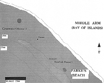
Figure 2. Parke’s Beach Site (DgBm-1), Newfoundland.
Recent Indian components affiliated with the Cow Head, Beaches, and Little Passage complexes have been previously confirmed and formally excavated or tested on the west coast of Newfoundland at Deer Lake Beach (Reader 1998a), Cow Head (Tuck 1978), Port au Port (Simpson 1984), Port au Choix (Renouf 1992), Bird Cove (Reader 1998b), and elsewhere (see Biggin 1985; Penney 1989; Schwarz 1994; Wallace 1991). Although groups of Beothuks undoubtedly also regularly inhabited at least some parts of the west coast of the Island in the early historic period (despite some dissenting views on this point; see Robbins 1989), historic documentation provides only one definite reference to a Beothuk group having been encountered by Europeans along this coast. This came in 1594 in the Bay St. George area near the Port au Port Peninsula (Quinn 1979:4:64-65) where several Beothuk dwellings were observed from the Bristol ship, the Grace. The Beothuks were likely encamped there to scavenge iron and other material from two wrecked Basque ships nearby (Pastore 1987:49). Another reference, to an aboriginal caribou hunting party on the west coast, encountered in the Bay of Islands around 1676 likely refers to Micmac or Innu, and not Beothuk (Martijn 1990:232). On a copy of James Cook’s hydrographic survey and coastal chart of the Bay of Islands of 1767 (Cook 1768) there is no reference to any visible signs of an aboriginal encampment (i.e. wigwams) at or in the vicinity of what is now known as Parke’s Beach, despite Cook’s two noted main anchoring points for his vessel, the Grenville, near this location.
Areal Description and Stratigraphy:
The Beothuk House 1 dwelling, Feature 10 (Figure 3), was situated in cultural Level 1 below a thin covering of peat, between 5-15 cm thick over the house interior, and up to 30 cm thick along the north wall and entrance area of the house. The feature was of house pit construction with a slightly excavated interior, with elevated beach gravel wall areas present around the house perimeter with the exception of the west side of the house where the natural topography begins to dip to an adjacent boggy area. The gravel wall area ranged between 10-35 cm higher in elevation than the house interior areas, with the wall being highest on the east side of the house where some post-occupational slumping of this wall seems to have occurred. Along the west periphery of the house two post holes were located marking the west boundary area of the house, associated with a concentration of secondary midden debris, consisting of fire-cracked and heated rocks, burned faunal bone, charcoal, wood ash and lithic flakes, along the southern portion of the west wall area. A clear gap in the beach gravel house wall at the northeast extent of the house was interpreted as the lone entranceway for the house. The perceived entranceway measured approximately 0.8 m in width and was oriented to the north-northeast, facing the shoreline. The wall area immediately to the southeast side of the entranceway featured a small concentration of clam shell (Mya arenaria) fragments.

Figure 3. Beothuk House 1, Parke’s Beach.
Several one metre square units were excavated below the Beothuk occupation level, up to a depth of 50 cm DBS, where an intact Dorset component with seemingly extensive and excellent faunal bone preservation was present. The Dorset component is discussed in more detail below.
The Beothuk house was of an elongated oval shape, based on the placement of the earthen peripheral wall and the discernible post holes. Measuring from post hole placements and the crests of the earthen walls, the maximum exterior dimensions of the house were 7 x 4.5 m north-south by east-west. Interior dimensions of the house were approximately 5.5 x 3.25 m north-south by east-west.
The house interior floor was composed of limestone beach gravel, smaller limestone rocks, scattered fire-cracked/heated rocks, and a covering of white-grey coloured wood ash over the southern interior floor. Within the house interior were noted two small hearth features of Beothuk affiliation, in Level 1. Hearth Feature 11 was located in the southeast quadrant of the house, very near the southeast wall of the dwelling. The noted ash covered area in the south portion of the house interior may have originated from this adjacent hearth. The other hearth, Feature 18, was located in the north-central house interior. A possible pit feature, Feature 17, was located in the centre of the house between the two hearth areas. A thin and discontinuous concentration of red ochre staining was noted in the soil matrix in the extreme southwest portion of the house interior/wall boundary area, associated with the Feature 13 secondary debris deposit. This red ochre staining was also present on many of the calcined faunal bone fragments found in this secondary midden deposit.
Above the house interior floor and Beothuk cultural level, and extending to immediately north of the house, below the sod level, was the noted peat layer of variable depth. This peat was composed almost entirely of decomposed birch twigs and birch bark, and at the Parke’s Beach site in general was only noted to be associated with this Beothuk House 1 feature. Given the superior positioning of this peat layer over the Beothuk level and its apparent association only with this house feature, it is probable that this layer was formed from a birch bark or birch branch covering over the structure, having collapsed subsequent to the abandonment of the house. Beothuk dwellings apparently often featured birch bark coverings, along with the use of other materials (see Howley 1915; Marshall 1996).
Beothuk Features in House 1:
A total of eight features were discerned within Level 1 at Beothuk House 1. They included three post holes within the house wall areas, two hearths, one midden or secondary cultural debris deposit at the southwest extent of the house interior, one secondary ash and charcoal lens in the northeastern interior of the house, and one rock-ringed, pit-like feature in the centre of the house, located between the two interior hearths.
Feature 11, Hearth.
The Feature 11 hearth was located at the southeast interior of the house, bordering the east house wall. Evident slumping of the wall here made the hearth appear to be closer to the wall than may originally have been the case. The hearth was relatively small and oval shaped, with maximum dimensions of 0.9 x 0.65 m, east-west by north-south. Minimal evidence of a discoloured, burned subsoil existed indicating an in situ burning, along with several smaller fire-cracked and heated rocks and one large, tabular sandstone slab which had been fire-heated and was decomposing, located in the east-central portion of the hearth. Two large, tabular, unmodified limestone slabs lay together just a few centimetres north of the hearth. Together, these last three larger, tabular rocks in and near the hearth could have been used as ‘anvil stones’ (Pastore 1992:30) for at least minimal working or hammering of European iron by Beothuks in this house feature. Within the boundaries of the hearth there was extensive charcoal and white ash staining in the soil, with small pieces of charcoal also present. A thin, fine lens of white ash was noted up to 1.5 m southwest of the hearth and most probably originated from the hearth itself. Lithic flakes were found within the hearth context, the majority of them having been heated or heat fractured. The placement and stratigraphic positioning of this hearth make it contemporaneous with the house occupation.
Feature 18, Hearth.
The Feature 18 hearth was located between 0.5 and 1.5 m southwest of the house entranceway, inside the house perimeter. Wall slumping, again, likely accounts for its present relative proximity to the wall area on either side of the entranceway. This hearth was also likely contemporaneous with the house occupation. The hearth was defined by minimal evidence of burned subsoil, charcoal staining and fragments of charcoal in the soil, fire-cracked rocks, and a fine lens of white ash, in and immediately around the hearth. Maximum dimensions of the hearth were 1.25 x 0.75 m, northeast-southwest by southeast-northwest.
Feature 9, possible Hearth.
Feature 9 was noted as a lens of charcoal and ash, but may also have been a hearth. This feature was located between the other two definite hearths, in the east-central portion of the house. It measured approximately 0.5 x 0.3 m, east-west by north-south. It was roughly triangular in outline and was composed of darkened (but not oxidized) soil, charcoal fragments, and decomposed, burned sandstone fragments. If this was a hearth then it was used very briefly and did not result in the subsoil actually becoming oxidized by the fire-heating. Regardless, the feature is contemporaneous with the house occupation.
Feature 13, Midden.
An actual midden area, Feature 13, consisting of secondary deposits of a variety of cultural debris was located in the southwest portion of the house interior, just inside the house wall crest as marked by an associated post hole (Feature 15). The stratigraphic placement of the deposit definitely makes it contemporaneous with the house occupation. The midden covered an excavated area of approximately 1.5 m2. The midden deposit had a maximum thickness of 10-15 cm and consisted of fire-cracked rocks, charcoal fragments, charcoal staining in the soil, a relatively high concentration of fire-heated and fractured lithic flakes, and both highly fragmented calcined and non-calcined faunal bone. An absence of a burned subsoil ruled out the scenario of in situ burning, justifying a midden interpretation, composed largely of hearth-related, secondary debris deposits. Two adjoining fire-cracked fragments of a triangular biface, several endscrapers, and one small fragment of incised bone were associated with the midden. Two large wood charcoal samples were collected from the midden deposit, but have not yet been dated. Tentatively identifiable faunal elements from this feature were those of seal, avia species, possible small land mammal, and one fragment of soft-shelled clam.
The midden feature is a compact crescent shape and is limited by the apparent southwestern interior curve of the house wall, although the midden deposit seems to continue just outside and west of the wall area. In fact, there is very little wall buildup here and the adjacent western portions of the house periphery; two post holes mark the house boundary in these areas. Again, this is also where the natural beach topography begins to drop off down to the adjacent boggy area just west of the house feature. A thin secondary debris deposit consisting of fire-cracked rocks, lithic flakes and small fragments of faunal bone was noted in test pits on the downward slope of the bank just to the west of the house feature.
Feature 17, possible Pit.
A possible pit feature, Feature 17, was located in the centre of the house between hearth Features 11 and 18. This was a depression of 12 cm deep, with a maximum upper width of 24 x 20 cm. Four larger, linear limestone rocks and several smaller limestone rocks defined the perimeter of the depression and were clearly associated with it. The top of the pit was at the top of Beothuk Level 1, suggesting its contemporaneity with the Beothuk occupation. Two chert flakes and a small amount of calcined and non-calcined faunal bone were found within the depression. Several small fragments of unidentifiable iron were found a few centimetres west of the feature. The specific function of this pit-like feature was not ascertainable from the available evidence, but that it may have been used to store food or other raw materials inside the house is quite possible. Compared to ethnohistorical observations of Beothuk storage pits, however, this feature is quite small. An alternative scenario is that this feature is the remnant of a large diameter central vertical support post for the house, although no use of a central vertical support post was noted by contemporary European observers of Beothuk house structures (see, Howley 1915; Marshall 1996:350-363). Despite some general similarities with Palaeoeskimo storage pits (see Renouf 1994), the possibility that this ‘pit’ feature was affiliated with a Dorset component was ruled out on the basis that the Dorset component in this area of the site was clearly situated below the Beothuk house feature, separated by sterile beach rock.
Features 12, 14, and 15, Post Moulds.
Three post moulds, Features 12, 14 and 15, were located around the house perimeter, with one clearly in the southeastern wall crest. The Feature 12 post mould was situated in the centre of the house wall on the southeastern periphery of the house. Approximately 10-12 cm deep, the post mould had an upper diameter of 18 cm with a basal diameter of 4.5 cm, suggestive of a relatively broad vertical support post for the house. The post mould was surrounded by the limestone gravel wall fill, with the post mould itself filled with loose black soil. The larger dimensions of this post mould compared to post moulds Features 14 and 15, and given its location at the southeast extent of the house, suggests that this was a larger vertical corner support post, perhaps similar to those noted by Cormack in 1822, where house posts were “…driven into the earth close to each other; the corners being made stronger than the other parts” (Howley 1915:211). The Feature 14 post mould was situated along the northwestern house periphery in an area of minimal gravel wall build-up. The post mould was 8 cm in depth with an upper diameter of 8 cm and a basal diameter of 5 cm. Relative to the Feature 12 post mould, this was a less substantive vertical support post for the house. The Feature 14 post mould was filled with loose, black organic soil as per Level 1 matrix. Post mould Feature 15 was located in the southwest portion of the house periphery. It was also filled with loose, black soil, with a vertical extent of 7 cm and an upper diameter of 7.5 cm and a basal diameter of 3.5 cm, again, a relatively smaller vertical support post for the house.
Recent Indian and Dorset Palaeoeskimo Features:
Below the upper Level 1 Beothuk house pit occupation component, limited evidence of what may be a Recent Indian (likely Little Passage) component was located just under the north low beach gravel wall build-up of the Beothuk house, in the form of a linear hearth in Level 2, in addition to a more substantive Dorset Palaeoeskimo component in much lower Level 4.
Feature 19, Hearth.
The possible Recent Indian component was detected under the north wall of the Beothuk house, as indicated by a linear hearth, Feature 19, measuring approximately 1.44 x 0.73 m, east-west by north-south. The hearth deposit was 17 cm thick, composed of a dense concentration of fire-cracked rock, highly fragmented and calcined faunal bone, charcoal fragments, and a small number of chert flakes. Overlying the hearth was a thin layer of unburned limestone rocks which was actually part of the Beothuk house wall. One sizeable wood charcoal sample was obtained from this hearth, but has not yet been dated. Although no diagnostic lithic tools were found associated with this hearth, the hearth is definitely Recent Indian by virtue of the dense concentration of fire-cracked rock and highly fragmented calcined faunal bone, and its linear shape. It is likely affiliated with a Little Passage period occupation, perhaps during the late prehistoric or early historic period, given its stratigraphic positioning relative to the upper Beothuk component.
Feature 20, Midden, and Feature 21, Post Mould.
A more substantive Dorset Palaeoeskimo component was noted in Level 3, situated 10-15 cm below the Recent Indian hearth, with a sterile deposit of limestone beach rock separating the two levels. The Dorset component continued virtually undisturbed under the entire Beothuk house component and associated Beothuk house wall fill, but clearly stratigraphically separated from it by a sterile layer of limestone beach rock. Within the Dorset component was an extensive faunal bone midden, Feature 20, with excellent bone preservation. Elements of seal, caribou, small land mammal, large avia species, and fish were tentatively identified in the field. One partial and two complete Dorset endblades were recovered from the Dorset bone midden, along with numerous chert flakes and microblades. One post mould, Feature 21, associated with the Dorset component was located in a sealed context, just beyond the northeast periphery of the Beothuk house. Thus additional evidence of some type of Dorset dwelling likely exists in the remaining unexcavated portions of Level 4 here, below the Beothuk and Recent Indian components.
Beothuk Lithic Artifacts and Materials:
From the Beothuk component associated with House 1 a total of 49 lithic artifacts were recovered. Utilized and retouched flakes, scrapers, and bifaces accounted for the majority of lithic artifacts (Table 2). One complete and two partial Beothuk/Little Passage projectile points were located inside the house in Level 1, as were all of the iron and nail fragments. The complete point, found in 1996, was small, stemmed, symmetrical and made of grey-green chert, with bifacial edge retouch and minimal ventral and dorsal surface retouch (Reader 1997). One of the partial examples was part of a basal portion of a relatively larger corner-notched point made of black chert (found in 1996; Reader 1997), while the other partial point discovered in 1997 was missing its base, thus the type of basal working was not discernible, but was finely bifacially edge retouched and was made of dark green-blue coloured chert. Two adjoining, fire-cracked fragments (basal and medial) of a triangular biface of grey-green chert were also recovered in 1997.
Table 2. Lithic1 and Iron Artifact Frequencies, Beothuk House 1, Parke’s Beach Site (DgBm-1).
| Lithic Artifacts | Frequency |
|---|---|
| Utilized Flakes | 15 |
| Scrapers | 10 |
| Bifaces | 9 |
| Retouched Flakes | 9 |
| Projectile Points | 3 |
| Biface Preform | 1 |
| Core Fragment | 1 |
| Flaked Quartzite Cobble | 1 |
| Total | 49 |
| Iron Artifacts | Frequency |
| Iron Pot Handle Fragments | 5 |
| Complete Nail | 1 |
| Nail Tip | 1 |
| Nail Shaft | 1 |
| Nail Head | 1 |
| Unidentified Iron Fragments | 15 |
| Total | 24 |
| Lithic and Iron Artifacts Total: | 73 |
| 1 Includes complete and fragmentary specimens. |
The metric and morphological attributes of the one complete and two partial projectile points associated with the Beothuk context strongly suggest an early historic period occupation, probably sometime prior to the eighteenth century. Thus, throughout the late seventeenth and eighteenth centuries, Beothuk lithic points become less symmetrical, with a higher width to length ratio, and less ventral and dorsal surface retouch (Schwarz 1984). Archaeological evidence suggests that by about the late eighteenth century the Beothuk actually seem to have replaced lithic points with ones made of modified iron nails (see, Devereux 1965; LeBlanc 1973; Pastore 1992). At Parke’s Beach, the Beothuk projectile points associated with Beothuk House 1 possess the highly symmetrical attributes of points associated with an early historic period occupation. In addition, the relatively high ratio of lithic to iron artifacts at House 1 also reflect an earlier occupation date in the historic period (see below). Thus, a relatively small amount of pilfered European materials, like iron, and a fully functioning lithic industry where cherts, quartzite and rhyolite were still the primary raw materials of choice for manufacturing various types of tools point to an early-historic period occupation at House 1.
The points made from pale coloured grey-green chert are typical of Little Passage and Beothuk raw material preferences for projectile point manufacture throughout the Island of Newfoundland. Various Island-wide sources of versions of this material were likely incorporated into regional Beothuk settlement and subsistence patterns (Deal and McLean 1997), while the material used for the noted points at Parke’s Beach very likely originated from a source for this type of chert on the Port au Port Peninsula (see Simpson 1984) on the west coast of Newfoundland. The predominant type of lithic material at House 1 was a dark green-blue chert, represented by both artifacts and flake debitage. This and other less frequent types of cherts associated with the Beothuk component likely have their origins in the various chert sources in the Cow Head area on the southwestern Northern Peninsula. Red jasper, represented by a core, a scraper, and several flakes at the house, has no confirmed source location in the region (Nagle 1985). Other non-local lithic materials within the house feature consist of numerous small flakes of a translucent, orange and black speckled quartzite which may have its origin on the Lower North Shore of Quebec (see Pintal 1989, 1990, 1992), and one large biface made of purple rhyolite procured from an unknown source location.
Iron Artifacts and Other European Materials:
A total of 24 iron fragments were found within the Beothuk house associated with the Beothuk features and lithic materials. This includes 15 fragments of unidentifiable iron, five pieces of round (1 cm diameter) cross-section which may be from an iron pot handle, one distal piece of a nail shaft, one medial portion of a nail shaft slightly bent on the most distal portion, one heavily corroded and possibly minimally hammered nail head, and one complete nail which has been bent into the typical ‘J’ shape from extraction, but which has not otherwise been aboriginally modified. All nail pieces, with the exception of the nail head, seem to be smaller boat nails. No other Beothuk modified iron artifacts were associated with the house.
The majority of the iron artifacts were located within the house with the exceptions of the complete nail which was located about 1 m outside the house entrance, and a cluster of seven small unidentifiable iron fragments from the upper portion of the southeast house wall fill. The remaining 17 nail and identifiable iron fragments came from seven different areas within the house, generally within the centre of the house and predominantly scattered just beyond the perimeter of hearth Feature 11, and immediately south of hearth Feature 18. No iron was found in the thin midden deposit, Feature 13, at the southwest house interior.
Overall, excluding lithic flake debitage, the ratio of iron to lithic artifacts at House 1 is relatively low at 24:49. This generally fits within the range of iron to lithic artifact ratios for House Pits 4 and 5 at the Beaches site, Bonavista Bay (Deal and McLean 1997:9; Taylor 1996: Table 10), but is far below the high ratio of iron to lithic artifacts at Beothuk House Pits 1, 3, 4, and 5 at Boyd’s Cove, Notre Dame Bay (Taylor 1996: Table 10; Pastore 1987). An absence of European artifacts which may be dated with any degree of precision at House 1 at Parke’s Beach necessitates the consideration of the iron to lithic artifact ratio as a rough indication of when in the historic period Beothuks may have occupied this house pit. Based on their recent research at the Beaches site Beothuk house pits, Deal and McLean (1997) cite evidence for a general trend at that location of Beothuks having increasingly used European iron over time; thus, a lower ratio of iron to lithic artifacts exists for an apparently earlier historic period (early seventeenth century) house pit, with an increased ratio of iron to lithic artifacts for house pits apparently occupied later on in the historic period (late seventeenth century). An increased use of pilfered iron, especially used in making iron projectile points (see Devereux 1965; McLean 1994; Pastore 1987) corresponds with a marked reduction in the quality of lithic projectile point manufacture. As noted, this trend was not in evidence at the excavated Beothuk component at Parke’s Beach.
Three non-iron artifacts of European origin were also found in House 1. One was a small fragment of a kaolin pipe stem. A second was a small fragment of plain white, tin- or salt-glazed ceramic. Both were found in the small Feature 13 midden inside the house, with the ceramic fragment having been slightly burned. Neither is suitable as a chronological marker. The third was a clear glass ‘rod’ fragment, 7 mm long and 3.5 mm in diameter.
Faunal and Botanical Evidence:
Preliminary analysis of both faunal elements and soil samples gathered for paleobotanical analysis from House 1 provide some limited indication of the season of house occupation. Small amounts of unburned and calcined faunal bone and clam shell were recovered from the Beothuk component, predominantly associated with the Feature 13 midden inside the house, and to one side of the entranceway of the house. Smaller fragments of burned and unburned faunal bone were recovered from various contexts inside the house. Initial in-field identification of faunal elements provided a general view of species representation and possible seasonality. Soft-shelled clam was most frequent in terms of MNI (MNI=21) and NISP (NISP=401), and one periwinkle shell was present, while vertebral elements of avia fauna were also noticed. Most of the clam shell fragments had been burned to a varying extent. By virtue of this, clam shell fragments from the entranceway had obviously been redeposited there as a secondary refuse deposit, from their original hearth association likely from inside the house.
Preliminary paleobotanical analysis of soil samples taken from the east wall of the entrance area of Beothuk House 1 did produce a total of eight (8) charred botanical specimens, which can safely be regarded as associated with the Beothuk occupation. These charred specimens consisted of four red elderberry (Sambucus pubens) seeds and four spruce needles (O’Driscoll and Bell 1997).
It is very likely that Beothuks were at Parke’s Beach when Europeans were not seasonally present in at least the outer Bay of Islands (see Pastore 1987; Pope 1993). This probability, and the presence of charred red elderberry seeds from red elderberry fruit which is available from June to August (Fernald 1987:1342), point to at least a probable late summer to early fall occupation at House 1. Soft-shelled clams could be procured after the ice retreated from the bay in the spring, until into early winter. They could also be obtained near the mouth of Cox’s Cove Brook, 1.5 km to the east (according to local informants), or at Lark Harbour located approximately 20 km to the southwest on the south shore of the Bay of Islands (Department of Fisheries 1987:24). The Bay of Islands is a key wintering area for eider ducks, and some islands within the bay feature breeding colonies of terns, gulls, and guillemots (Cairns et al. 1986). Therefore, from the preliminary faunal analysis the presence of avia fauna elements from House 1 is not seasonlly indicative in and of itself.
Discussion of the Beothuk House 1 Occupation:
The available evidence from Beothuk House 1 at Parke’s Beach is suggestive of a Beothuk occupation there most probably before the mid-eighteenth century. Suggestive evidence for this, based on the relative quantities of iron to lithic artifacts and the metric and morphological attributes of the lithic projectile points associated with the house have been discussed. Further, the dynamics and chronology of European seasonal and subsequent permanent settlement in the Bay of Islands region also seem to support this scenario. Documentary sources and archaeological evidence show that between about AD 1590-1700 Basque fishing vessels seasonally visited at least one, and possibly two, ports on the south shore of the outer Bay of Islands (Barkham 1989; Schwarz 1994). This was primarily for summer cod fishing and may have included the procuring of seals in the outer bay during the late spring of the year (Barkham 1989). No other Europeans seem to have regularly and seasonally fished in the bay during the seventeenth century; as for the early-eighteenth century, the French, under their French shore treaty fishing rights, regularly seasonally fished for cod in the southern outer bay areas (Mannion 1977). Similar intensive seasonal use of the Bay of Islands by English fishermen began by the mid- to late-eighteenth century, and was apparently concentrated in the inner or eastern bay areas (Mannion 1977; Reader 1996). Thus, beginning in the early eighteenth century, and increasingly so by the mid-eighteenth century, European seasonal fishing in the Bay of Islands became more intensive with the French concentrating on the cod fishery in the outer Bay of Islands and the English on the inner bay salmon fishery (Mannion 1977). Permanent settlement and over-wintering in the Bay of Islands began with English settlers ca. 1800-1810, near the mouth of the Humber River in the inner bay (Mannion 1977; Reader 1996). Apart from Europeans, documentary evidence of Micmac hunters and settlers in and around the Bay of Islands is noted for as early as the 1760s and 1770s (Marshall 1996:50; Anger 1988).
Given the characteristic Beothuk pattern of pilfering iron and other materials from seasonally abandoned European fishing premises along Newfoundland’s east and northeast coasts, and the apparent abandonment of some of the Beothuk’s own seasonal sites on the coast when permanent European settlements were established too close to them, it is plausible that a similar scenario could have chronologically and geographically restricted Beothuk seasonal coastal settlement in western Newfoundland as well. Based on such an assumption and considering the relatively late development of permanent English occupations in the Bay of Islands area, the Beothuk component at Parke’s Beach could theoretically have been occupied as late as the late eighteenth century. However, based on the increased seasonal use of the bay by French and English and even Micmac groups by the latter half of the eighteenth century, the most plausible period of occupation of House 1 at Parke’s Beach is within the period 1590-1750. Again, the relatively high ratio of lithic to iron artifacts at the Beothuk house at Parke’s Beach also generally suggests a Beothuk occupation here in the earlier part of the historic period.
Evidence of the Beothuk having utilized a traditional lithic tool industry at Parke’s Beach with only a secondary, if not ephemeral, use of iron may suggest that Beothuk on that part of the west coast at that time were yet following a pattern of settlement and resource use very similar to that of their (Little Passage affiliated) ancestors. Evidence of a possible Little Passage component under a portion of the Beothuk component here may attest to this, as does the presence of another Little Passage component approximately 20 km away on the outer south shore of the bay (Schwarz 1994:20). The decision for Beothuks to have seasonally occupied the Parke’s Beach location, as did their ancestors perhaps only a century two before, likely reflects a regular seasonal summer and early fall move to the sheltered inner bay location to procure at least avia fauna, soft-shelled clams, and edible berries, as the faunal and botanical evidence attest. A similar situation is evident at the Beothuk component at the Beaches, Bonavista Bay, where seventeenth century Beothuk occupations there apparently followed a ‘traditional’ settlement and subsistence pattern, largely unaltered by access to European materials at that time (Deal and McLean 1997; McLean 1994). At Parke’s Beach, the Beaches and at other northeast coast Beothuk sites, it is the additional provision of access to European iron from nearby seasonally abandoned fishing stations which may have been prosecuted in a secondary manner to traditional resource procurement; at least until about the late-seventeenth to early-eighteenth century.
The House 1 dwelling feature itself at Parke’s Beach provides important new information on Beothuk house construction methods and the reasons behind these methods, to augment that already obtained elsewhere on the Island through ethnohistorical documentation (see Howley 1974; Marshall 1996) and archaeological excavations (Devereux 1965, 1969, 1970; LeBlanc 1973; McLean 1993, 1994; Pastore 1984, 1985, 1986). The immediate prehistoric ancestors of the Beothuk, the Little Passage and Beaches complex affiliated groups, did not construct house pits which featured characteristic excavated interiors and peripheral wall build-up of earth. Archaeological evidence supports the view that these ancestors of the Beothuk constructed relatively non-substantial tent dwellings without pit house construction, while tangible evidence of any type of Recent Indian dwelling is relatively rare in Newfoundland, Labrador and the Lower North Shore of Quebec (Austin 1984; Loring 1985; Pastore 1992; Pintal 1989). The implication is that, by comparison with the Beothuk evidence, Recent Indian dwellings were associated with very short-term occupations. The historic Beothuk, however, switched to constructing house pits very early on in the historic period, perhaps beginning as early as around AD 1600, in part, in anticipation of remaining at specific locations for relatively longer periods of time.
Evidence of cultural formation processes associated with the Beothuk occupation of the House 1 feature comes from the composition, placement, and extent of the debris deposits. There exist no large secondary midden deposits with a relative diversity of material types which would indicate a relatively long period of occupation, entailing intense and varied associated tasks by house occupants. What seems to be a small, single secondary deposit of debris is Feature 13, located just within the southwest interior of the dwelling. This secondary deposit is situated mainly within the house, with what may be a thinner continuation of the same deposit located adjacent to the southwest exterior of the house. The horizontal position of a post mould (Feature 15) within this deposit seems to clearly demarcate this key boundary distinction.
In terms of ‘architectural’ features the House 1 dwelling at Parke’s Beach generally follows a house pit construction method with areas of raised earthen walls on the east and south house margins and evidence of at least minimal excavation of adjacent parts of the house interior. However, this house is not entirely typical of historic Beothuk house pits noted elsewhere in Newfoundland. The excavated Beothuk house feature at Parke’s Beach had typical low, slumped earthen walls on its east and south margins. On the north and west margins of the house there was no clearly defined earthen wall. Instead, there was a low elevation, dense accumulation of fire-cracked/heated rocks and other cultural debris. This suggests a partial discard perimeter, in contrast to purposefully built-up low earthen house walls. This periphery was slightly more pronounced on the north boundary of the house. Two post holes situated along the western wall area clearly marked it as the actual house periphery on the edge of the small slope to the west of the house. Thus, unlike Beothuk house pits from other sites (see Carignan 1977; Devereux 1965, 1970; LeBlanc 1973; Marshall 1996; McLean 1993, 1994; Pastore 1986), the Beothuk house at Parke’s Beach was only partially defined by a typical mounded earthen wall. There is no indication that the northern and western peripheral areas of the house may actually have featured low earthen walls which may have subsequently slumped altogether. The in situ nature of cultural debris in these areas mitigates against such an interpretation. Again, that there was relatively little iron in this house, and none of it extensively modified, suggests that the Beothuk occupation here may have been relatively early on in the historic period, almost certainly before 1750, as discussed above, and based on the atypical nature of the house feature itself, it may possibly be much earlier in the historic period (ca. late sixteenth to early seventeenth century). The late Little Passage/Beothuk style projectile points here also support this position.
Given this highly probable scenario then, the Beothuk dwelling at Parke’s Beach can be interpreted as providing relatively rare information on, perhaps, some of the earliest Beothuk choices to switch from more temporary ‘wigwam’ dwellings to house pit construction. In effect then, we may now have virtually unequivocal archaeological evidence to suggest that Beothuk groups both on the east coast and west coast of Newfoundland made the general switch to constructing house pits or an early version thereof, from ground-level tent dwellings, very early in the historic period. This occurred, it seems, perhaps within only a few years after the first regular contacts with Europeans or at least, with their material culture.
Possible evidence of the Beothuks having occasionally used non-pit house type dwellings in the early historic period, does suggest that Beothuks retained usage of more temporary tent-type dwellings. Such evidence has been noted at Inspector Island, Notre Dame Bay, in the form of a U-shaped dwelling delineated by a peripheral arrangement of ‘hold-down’ rocks (Pastore 1989:260, Figure 2), in addition to possible early historic Beothuk tent structures suggested by hearth placements at the Russell’s Point site, eastern Newfoundland (Gilbert 1995, 1996). The House 1 Beothuk dwelling at Parke’s Beach may also, in part, reflect some of these ‘temporary structure’ characteristics.
The meager evidence we do have suggestive of season of occupation at Beothuk House 1 at Parke’s Beach points toward a possible late summer to early fall occupation. This evidence, in the context of what may be a very early contact period occupation of relatively short duration, supports the position that Beothuks in the early historic period were still following ‘traditional’ patterns of subsistence and settlement, which also afforded access to European iron (McLean 1994:83-84). Thus, the theory of temporary late summer and early fall camps in coastal areas where Beothuks exploited primarily coastal resources, before moving into the interior in the fall (Marshall 1996; Rowley-Conwy 1990; Schwarz 1984), loosely conforms with the Parke’s Beach evidence. The Beothuk House 1 dwelling at Parke’s Beach does not entirely conform to the recorded characteristics of other typical Beothuk house pits, yet evidence of post holes (one of large diameter) and a partially excavated interior forming earthen walls along just the east and south margins of the dwelling clearly set it apart from more ephemeral Recent Indian temporary tent structures.
Speculatively, Beothuks also may have begun constructing more substantial dwellings to accommodate longer site occupations as a partial response to a marginal early historic fur trade with Europeans, and not exclusively as a means to accessing European iron by pilfering from abandoned fishing premises. Limited evidence of the Beothuks’ likely involvement in an early historic marginal fur trade with Europeans comes from archaeological faunal evidence from Boyd’s Cove (Pastore 1987), and from ethnohistoric accounts such as John Guy’s and Henry Crout’s accounts of trading with groups of Beothuks in Trinity Bay in 1612 and 1613, respectively (Marshall 1996:28-33). However, by the early seventeenth century a regular fur trade between Beothuks and Europeans had not developed (see Pastore 1987), and the Beothuks’ continued construction of house pits may have then been partially linked to providing relatively longer access to iron from abandoned European fishing premises, at least for sites on or very near the coast. If this theory is even tenable, then it is perhaps suggestive of a localized, east coast early fur trade. Beothuk wigwams observed at St. Georges Bay on the west coast of Newfoundland in 1594 (Marshall 1996:23-24; Quinn 1979:4:64-65) may suggest that Beothuks were there to acquire iron from wrecked Basque ships nearby (Pastore 1987:49). It is most unfortunate that the original description of several Beothuk dwellings in St. Georges Bay in 1594 apparently did not discern if the observed dwellings had characteristics of house pits or of ground level structures (see Quinn 1979:4:64). Regardless if either the tenable ‘access to iron’ theory, or the speculative ‘marginal fur-trade’ position are considered, it is likely that the underlying impetus for Beothuks having constructed house pits would remain constant: to have partially provided Beothuks with a means to occupy sites for anticipated relatively longer periods at a time.
Conclusions
The 1997 field season at the Parke’s Beach site accomplished the initial goals for this season’s research. First, the completion of excavations at Groswater House 1 significantly added to our data on Groswater seasonal house types, while providing a representative artifact assemblage from the house occupation and an informative faunal assemblage predominantly from a midden feature. Second, the partial excavation of Beothuk House 1 at the site provided potentially important and necessary data on a Beothuk house form and the nature of their use of European iron, from the west coast of Newfoundland. Much of the data may suggest a Beothuk presence at Beothuk House 1 relatively early in the historic period.
What is blatantly evident from this author’s investigations at the Parke’s Beach site is that there is a large amount of potentially informative archaeological field research yet to be done at this site, especially with regard to the relatively large Groswater Palaeoeskimo component. In 1997, the Dorset component was shown to be more expansive than previously known, while there remains a possibility that additional Beothuk or Recent Indian sub-components may be detected at the site by further, very intensive and systematic test-pitting. The base of what seems to be a Little Passage projectile point from just outside the Groswater House 1 southeast boundary also hints at this likelihood.
References
Anger, D.
1988 – Noywa’mkisk (Where the Sand Blows… ): Vignettes of Bay St. George Micmacs. Bay St. George Regional Indian Band Council, Port au Port East, Newfoundland.
Anton, E., S. Hull, D. Laybolt, and T. von Hunnius
1997 – “A View from the Beach: Analysis of Faunal Material from Groswater House 1, Parke’s Beach (DgBm-1), Newfoundland.” Report for Archaeology 6890, Department of Anthropology, Memorial University of Newfoundland, St. John’s.
Auger, R.
1982 – “A Preliminary Report on Early Dorset Occupations on the West Coast of Newfoundland.” In, Archaeology in Newfoundland and Labrador, 1981. Annual Report #2, edited by J. Sproull Thomson and C. Thomson, pp. 130-151. Historic Resources Division, Department of Culture, Recreation and Youth, Government of Newfoundland and Labrador, St. John’s.
1984 – “Factory Cove: Recognition and Definition of the Early Palaeo-Eskimo Period in Newfoundland.” M.A. thesis, Department of Anthropology, Memorial University of Newfoundland, St. John’s.
Austin, S.
1984 – “Maritime Archaic and Recent Indian Evidence from Cape Cove Beach, Newfoundland.” Canadian Journal of Archaeology 8(2):115-126.
Barkham, S.
1989 – The Basque Coast of Newfoundland. Great Northern Peninsula Development Corporation.
Biggin, M.S.
1985 – “Prehistoric Indian Sites at Portland Creek: EbBj-4, 5.” Report on file at Culture and Heritage Division, Department of Tourism, Culture and Recreation, Government of Newfoundland and Labrador, St. John’s.
Cairns, D.K., R.D. Elliot, W. Threlfall, and W.A. Montevecchi
1986 – “Researcher’s guide to Newfoundland Seabird Colonies.” Memorial University Occasional Papers in Biology #10. St. John’s.
Carignan, P.
1977 – Beothuck Archaeology in Bonavista Bay. Archaeological Survey of Canada, Mercury Series #69. National Museum of Man, Ottawa.
Cook, James, Capt.
1768 – A Chart of the West Coast of Newfoundland. Copy on file at the Fisher Rare Book Library, University of Toronto.
Crowley, K., and L. Hartery
1997 – “A Discussion and Analysis of the Botanical Remains from the Dorset and Groswater Paleoeskimo Sites at Dildo Island and Parke’s Beach, Newfoundland.” Paleoethnobotany report for Anthropology 4151, Department of Anthropology, Memorial University of Newfoundland, St. John’s.
Deal, M., and L. McLean (eds.)
1997 – “The Beaches Archaeological-Paleoethnobotanical Project: 1995 Fieldwork Report.” Report on file at the Culture and Heritage Division, Department of Tourism, Culture and Recreation, Government of Newfoundland and Labrador, St. John’s.
Department of Fisheries, Government of Newfoundland and Labrador
1987 – Soft Shelled Clam Survey. Industry Support Services Report #37. St. John’s.
Devereux, H.E.
1965 – “The Pope’s Point Site (DfBa-1), Newfoundland.” Report on file at the Centre for Newfoundland Studies, Memorial University of Newfoundland, St. John’s.
1969 – “Five Archaeological Sites in Newfoundland.” Report on file at the Centre for Newfoundland Studies, Memorial University of Newfoundland, St. John’s.
1970 – “A Preliminary Report on the Indian Point Site, Newfoundland: A Stratified Beothuk Site.” MS on file at the Centre for Newfoundland Studies, Memorial University of Newfoundland, St. John’s.
Fernald, M.L.
1987 – Grey’s Manual of Botany. Eighth Edition. Droscorided, Portland, OR.
Fitzhugh, W.W.
1977 – “Indian and Eskimo/Inuit Settlement History in Labrador: An Archaeological View.” In, Our Footprints are Everywhere: Inuit Land Use and Occupancy in Labrador, edited by C. Brice-Bennett, pp.1-41. Labrador Inuit Association, Dollco Printing.
Gilbert, W.
1995 – “Russell’s Point, 1994: A Report on the Russell’s Point Archaeology Project, July 4 to November 18, 1994.” Report on file at the Culture and Heritage Division, Department of Tourism, Culture and Recreation, Government of Newfoundland and Labrador, St. John’s.
1996 – “Baccalieu Trail Archaeology Project, 1995, Phase 2: Russell’s Point.” Report on file at the Culture and Heritage Division, Department of Tourism, Culture and Recreation, Government of Newfoundland and Labrador, St. John’s.
Harp, E. Jr.
1964 – The Affinities of the Newfoundland Dorset Eskimo. National Museum of Man, Bulletin #200, Ottawa.
Howley, J.P.
1974 – The Beothucks or Red Indians. Reprinted. Coles, Toronto. Originally published 1915, Cambridge University Press, Cambridge.
LeBlanc, R.J.
1973 – “The Wigwam Brook Site and the Historic Beothuk Indians.” M.A. thesis, Department of Anthropology, Memorial University of Newfoundland, St. John’s.
Linnemae, U.
1975 – “The Dorset Culture: A Comparative Study in Newfoundland and the Arctic.” Technical Papers of the Newfoundland Museum #1. Newfoundland Museum, St. John’s.
Loring, S.
1985 – “Archaeological Investigations into the Nature of the Late Prehistoric Indian Occupation in Labrador: A Report on the 1984 Field Season.” In, Archaeology in Newfoundland and Labrador 1984, edited by J. Sproull Thomson and C. Thomson, pp. 122-153. Annual Report #5. Historic Resources Division, Department of Culture, Recreation and Youth, Government of Newfoundland and Labrador, St. John’s.
Loring, S., and S.L. Cox
1986 – “The Postville Pentecostal Groswater Site, Kaipokok Bay, Labrador.” In, Palaeo-Eskimo Cultures in Newfoundland, Labrador and Ungava. Reports in Archaeology 1, Memorial University of Newfoundland, St. John’s. pp. 65-93.
Mannion, J.J.
1977 – “Settlers and Traders in Western Newfoundland.” In, The Peopling of Newfoundland: Essays in Historical Geography, edited by J.J. Mannion. Institute of Social and Economic Research, Memorial University of Newfoundland, St. John’s. pp. 234-275.
Marshall, I.
1996 – A History and Ethnography of the Beothuk. McGill-Queen’s University Press, Montreal.
Martijn, C.A.
1990 – “Innu (Montagnais) in Newfoundland.” In, Papers of the Twenty-First Algonquian Conference, edited by W. Cowan. Carleton University, Ottawa. pp. 227-246.
McLean, L.
1993 – “Burnside Heritage Project 1992 Archaeological Report.” Report on file at the Culture and Heritage Division, Department of Tourism, Culture and Recreation, Government of Newfoundland and Labrador, St. John’s.
1994 – “Back to the Beaches: New Data Pertaining to the Early Beothuk in Newfoundland.” Northeast Anthropology 47:71-86.
Nagle, C.
1985 – “Lithic Raw Material Resource Studies in Newfoundland and Labrador: A Progress Report.” In, Archaeology in Newfoundland and Labrador 1984, edited by J. Sproull Thomson and C. Thomson. Annual Report #5. Historic Resources Division, Department of Tourism, Culture and Recreation, Government of Newfoundland and Labrador, St. John’s. pp. 86-121.
O’Driscoll, C., and V. Bell
1997 – “Paleoethnobotanical Analysis of Two Historic Beothuk Sites: Parke’s Beach, Bay of Islands, and Russell’s Point, Trinity Bay, Newfoundland.” Report on file at the Archaeology Unit, Memorial University of Newfoundland, St. John’s.
Pastore, R.T.
1984 – “Excavations at Boyd’s Cove, Notre Dame Bay, 1983.” In, Archaeology in Newfoundland and Labrador 1983, edited by J. Sproull Thomson and C. Thomson. Annual Report #4. Historic Resources Division, Department of Culture, Recreation and Youth, Government of Newfoundland and Labrador, St. John’s. pp. 98-125.
1985 – “Excavations at Boyd’s Cove, 1984: A Preliminary Report.” In, Archaeology in Newfoundland and Labrador 1984, edited by J. Sproull Thomson and C. Thomson. Annual Report #5. Historic Resources Division, Department of Culture, Recreation and Youth, Government of Newfoundland and Labrador, St. John’s. pp. 322-337.
1986 – “Excavations at Boyd’s Cove: The 1985 Field Season.” In, Archaeology in Newfoundland and Labrador 1985, edited by J. Sproull Thomson and C. Thomson. Annual Report #6. Historic Resources Division, Department of Culture, Recreation and Youth, Government of Newfoundland and Labrador, St. John’s. pp. 218-232.
1987 – “Fishermen, Furriers, and Beothuks: the Economy of Extinction.” Man in the Northeast 33:47-62.
1989 – “Report for Permit No. 86.16: Inspector Island (DiAq-1).” In, Archaeology in Newfoundland and Labrador 1986, edited by J. C. Thomson and J. S. Thomson. Annual Report #7. Historic Resources Division, Department of Municipal and Provincial Affairs, Government of Newfoundland and Labrador, St. John’s. pp. 260-269.
1992 – Shanawdithit’s People: The Archaeology of the Beothuks. Atlantic Archaeology, St. John’s.
Penney, G.
1989 – “Historic Resources Overview Assessment of Three Water Crossings and Two Re-alignments on the Proposed Berry Hill to Daniel’s Harbour Transmission Line.” Report on file at Culture and Heritage Division, Department of Tourism, Culture and Recreation, Government of Newfoundland and Labrador, St. John’s.
Pintal, J-Y.
1989 – “Contributions à la pré histoire ré cente de Blanc-Sablon.” Recherches amé rindiennes au Qué bec XIX(2-3):33-44.
1990 – “Sé riation des Matières Premières Lithiques à Blanc-Sablon: é change ou Mobilité Territoriale?” Arché ologiques 3-4:87-97.
1992 – “La Distribution des Maté riaux Lithiques en Basse-Côte-Nord Orientale.” Arché ologiques 5-6:59-67.
1994 – “A Groswater Site at Blanc-Sablon, Quebec.” In Threads of Arctic Prehistory: Papers in Honour of William E. Taylor, Jr., edited by D. Morrison and J-L. Pilon. Mercury Series #149. Canadian Museum of Civilization, Hull. pp. 145-164.
Pope, P.E.
1993 – “Scavengers and Caretakers: Beothuck/European Settlement Dynamics in Seventeenth Century Newfoundland.” Newfoundland Studies 9(2):279-293.
Quinn, D.B.
1979 – New American World: A Documentary History of North America to 1612. Arno, New York.
Reader, D.
1996 – “Archaeological Investigations Along the North Shore of the Bay of Islands, Newfoundland, 1995.” Report on file at the Culture and Heritage Division, Department of Tourism, Culture and Recreation, Government of Newfoundland and Labrador, St. John’s.
1997 – “Archaeological Excavations at Parke’s Beach, Bay of Islands, 1996: Groswater and Dorset Palaeoeskimo and Beothuk Components. Report on file at the Culture and Heritage Division, Department of Tourism, Culture and Recreation, Government of Newfoundland and Labrador, St. John’s.
1998a – “Early Recent Indian Interior Occupation at Deer Lake Beach: Implications for Theories of Recent Indian and Beothuk Resource Use, Settlement, and Social Organization in Newfoundland.” Northeast Anthropology 55. In Press.
1998b – “The 1997 Archaeological Survey of the Bird Cove Area, Northwestern Northern Peninsula, Newfoundland.” Report on file at Culture and Heritage Division, Department of Tourism, Culture and Recreation, Government of Newfoundland and Labrador, St. John’s.
Renouf, M.A.P.
1992 – “The 1991 Field Season, Port au Choix National Historic Park: Report of Archaeological Excavations.” Report on file at Archaeology, Atlantic Region, Canadian Parks Service, Halifax, Nova Scotia.
1993 – “Palaeoeskimo Seal Hunters at Port au Choix, Northwestern Newfoundland.” Newfoundland Studies 9(2):185-212.
1994 – “Two Transitional Sites at Port au Choix, Northwestern Newfoundland.” In, Threads of Arctic Prehistory: Papers in Honour of William E. Taylor, Jr., edited by D. Morrison and J-L. Pilon. Canadian Museum of Civilization, Hull. pp. 165-195.
Rowley-Conwy, P.
1990 – “Settlement Patterns of the Beothuk Indians of Newfoundland: A View From Away.” Canadian Journal of Archaeology 14:13-32.
Ryan, K.A.
1997 – “Groswater Palaeo-Eskimo Toolmakers: Phillip’s Garden West and Beyond.” Paper presented at the 30th Annual Canadian Archaeological Association Conference, Saskatoon, Saskatchewan.1997 “Groswater Palaeo-Eskimo Toolmakers: Phillip’s Garden West and Beyond.” Paper presented at the 30th Annual Canadian Archaeological Association Conference, Saskatoon, Saskatchewan.
Schiffer, M.B.
1987 – Formation Processes of the Archaeological Record. University of New Mexico Press, Albuquerque, NM.
Schwarz, F.A.
1984 – “The Little Passage Complex in Newfoundland: A Comparative Study of Assemblages.” B.A. Honours dissertation, Department of Anthropology, Memorial University of Newfoundland, St. John’s.
1994 – “Archaeological Investigations in the Bay of Islands, Western Newfoundland, September-October 1994.” Report on file at the Culture and Heritage Division, Department of Tourism, Culture and Recreation, Government of Newfoundland and Labrador, St. John’s.
Sergeant, D.D.
1991 – Harp Seals, Man and Ice. Canadian Special Publications of Fisheries and Aquatic Sciences, #114. Department of Fisheries and Oceans, Ottawa.
Simpson, D.N.
1984 – “The Port au Port Peninsula Archaeology Project: Preliminary Report.” In, Archaeology in Newfoundland and Labrador 1983, edited by J. Sproull Thomson and C. Thomson. Annual Report #4. Historic Resources Division, Department of Culture, Recreation and Youth, Government of Newfoundland and Labrador, St. John’s. pp. 126-141.
Stevenson, M.G.
1991 – “Beyond the Formation of Hearth-Associated Artifact Assemblages.” In, The Interpretation of Archaeological Spatial Patterning, edited by E.M. Kroll and T.D. Price. Plenum, New York. pp. 269-299.
Stopp, M.P.
1997 – “Long-term Coastal Occupancy between Cape Charles and Trunmore Bay, Labrador.” Arctic 50(2):119-137.
Taylor, D.N.
1996 – “The Beaches Site (DeAk-1): A Comparative Study of Housepit Features.” B.A. Honours dissertation, Department of Anthropology, Memorial University of Newfoundland, St. John’s.
Tuck, J.A.
1978 – “Excavations at Cow Head, Newfoundland: An Interim Report.” é tudes/Inuit/Studies 2(1):138-141.
Wallace, B.L.
1991 – “L’Anse aux Meadows: Gateway to Vinland.” Acta Archaeologica 61:166-197.
Wilson, D.C.
1994 – “Identification and Assessment of Secondary Refuse Aggregates.” Journal of Archaeological Method and Theory 1(1):41-68.