
Archaeology in Newfoundland and Labrador 1997
Edited by K. Nelmes
Searching for the Maritime Archaic Indian Habitation Site at Port au Choix, Newfoundland: An Integrated Approach Using Archaeology, Geomorphology and Sea Level History
M.A.P. Renouf and Trevor Bell
Summary
This report describes how an innovative, interdisciplinary research approach led to a breakthrough archaeological find at Port au Choix, northwestern Newfoundland. A richly accoutred and well preserved Maritime Archaic Indian burial site (4400-3300 b.p. [1]) was discovered at Port au Choix in the late 1960s, and excavations by James A. Tuck of Memorial University of Newfoundland revealed it to be one of the largest hunter-gatherer burial sites in North America. One of the vexing questions that has plagued archaeologists ever since is the whereabouts of the habitation site that must have accompanied the cemetery. This site would yield valuable data on the day-to-day life of the Maritime Archaic Indians which would complement the existing information from the cemetery on ideology, health, diet, and hunting/fishing activities. However, despite many years of site surveys, the Port au Choix habitation site was never found. In 1996 we re-opened the search and developed a model of site location that incorporated elements of relative sea level history, palaeogeography and culture history. We tested our model during the 1997 field season, funded in part by the Culture and Heritage Division of the Department of Tourism, Culture and Recreation, and we found the site exactly where predicted. Characteristics of its location explain why the site had remained hidden for so long. Initial observations suggest that the site is extensive, and radiocarbon dates (3740 ± 50 b.p. and 3270 ± 50 b.p.) confirm its contemporaneity with the Maritime Archaic Indian cemetery. A possible Recent Indian component is also dated (1520 ± 60 b.p.).
Introduction
This report describes the results of our 1997 field season at Port au Choix, on the northwest coast of Newfoundland (Fig. 1). Archaeology and sea level history were integrated to produce a detailed model of Maritime Archaic Indian settlement location, and subsequent testing of the model located this important site where predicted.
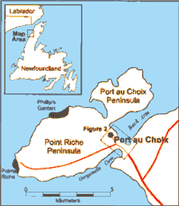
Figure 1. Location Map.
The Maritime Archaic Indians of Port au Choix
Port au Choix comprises the Point Riche and Port au Choix Peninsulas, and together these project into the Gulf of St. Lawrence just south of the Strait of Belle Isle. A narrow isthmus, 7 m asl (above sea level) at its lowest point, connects these two peninsulas to each other. A second isthmus, 3 m asl at its lowest elevation, connects both peninsulas to the coast of the Northern Peninsula. The main area of the town of Port au Choix is located on the Point Riche Peninsula, from which there is an eastward view onto the harbour, known as Back Arm.
Water depth rapidly increases offshore, creating upwelling conditions which in turn give rise to productive marine life. These rich marine resources have attracted humans to Port au Choix from as early as 4400 years ago to the present day. Prehistoric inhabitants include Maritime Archaic Indians (4400-3300 b.p.), Groswater Palaeoeskimos (2800-1900 b.p.), Dorset Palaeoeskimos (2000-1300 b.p.), and Recent Indians (1500-800 b.p.). As a result of this archaeological richness, there is scarcely a spot in the main town where construction activities would not disturb a site.
Our research focuses on the Maritime Archaic Indian (MAI) occupation of Port au Choix. These hunter-gatherer-fishers reached Labrador at about 9000 b.p., representing the final expansion of the Palaeoindian migration across the New World (McGhee and Tuck 1975). According to present evidence, the MAI moved onto the island of Newfoundland at about 5000 b.p. (Carignan 1975), presumably coming across the Strait of Belle Isle which is 18 km wide at its narrowest point.
Relatively few MAI habitation sites have been excavated on the island of Newfoundland, and information from them is limited (Carignan 1975, MacLeod reported in Tuck 1976, Austin 1980, Reader 1996). By contrast, the largest and most informative MAI site in Newfoundland is the well-excavated and well-reported cemetery at Port au Choix (Tuck 1970, 1971, 1976). This site is located in the town centre, to the landward side of the main road, along a 6-8 m asl raised sandy beach (Fig. 2). As early as 1939 local residents uncovered skeletons and grave goods in this area. They later gave these to Elmer Harp Jr., of Dartmouth College, who attributed the finds to the Archaic Indians who were known to have produced “Red Paint Cemeteries” in coastal Maine (Harp 1951, 1963, 1964, Harp and Hughes 1968).
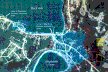
Figure 2. Aerial photograph of the main settlement of Port au Choix (see Fig. 1) showing the location of the MAI cemetery in relation to elevation and topography. The cemetery extends along the 6-8 m marine terrace behind the town’s main street. At the time of cemetery use, the active beach was located below the 6 m contour interval. Thus, the cemetery was situated on an island.
In 1967 expansion of the town led to the site’s chance discovery when a local businessman excavated a basement for a new premises and in the process uncovered a number of well-preserved skeletons covered in red ochre. James A. Tuck, of Memorial University of Newfoundland, was called to the area and in 1968 he excavated what remained of those graves. He established the boundaries of the site and excavated three burial loci. He excavated a fourth in 1978, by which time a total of over 117 skeletons were excavated in over 56 graves. In the years that followed an unrecorded number of skeletons continued to be uncovered sporadically as new houses and sheds were built in the main town area. By 1996 it was clear that the burials extended along the full length of the 6-8 m terrace in the town centre (Fig. 2). A series of six radiocarbon dates place the cemetery between 4400 and 3300 b.p. (Table 1; Tuck 1976: 172).
The skeletal material is well studied (Anderson 1976, Kennedy 1981, 1987, Pfeiffer 1977, Marshall 1990, Reader 1990, Evans 1991, Jerkic 1993) and results point to a relatively healthy population. Although mortality was high for those under two years of age, those who survived this period could expect to live into their mid-forties and perhaps their mid-fifties (Jerkic 1993:219). There was evidence of minor activity-related arthritis (Anderson 1976, Marshall 1990), but no evidence of disease beyond a few individual pathologies (Jerkic 1993:219). Teeth were virtually caries-free but extremely worn (Anderson 1976), consistent with a high fibre and low sugar and carbohydrate diet, as well as use of teeth as tools, for example, in activities such as softening skin (Tuck 1970, Reader 1990).
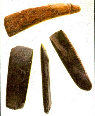
Figure 3. Woodworking tools from the MAI cemetery; note gouge on far right. (Photo: Jim Tuck)
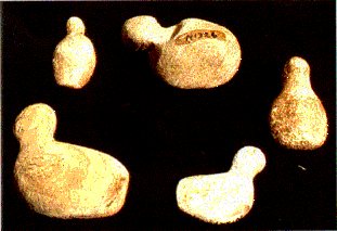
Figure 4. Stones resembling sitting or floating birds. (Photo: Jim Tuck)
Artifacts found in the graves reflect a vital society. The importance of woodworking is clear in the many ground slate gouges and axes that were found (Fig. 3), and Tuck (1976:84) speculates that these could have been used to make dugout canoes, dwellings, as well as small items such as trays and bowls, not to mention decorative items. Marine hunting is evident in the bone and ivory harpoons and harpoon heads, bone foreshafts, and the long narrow ground slate lances. There were component parts of fish spears, and caribou could have been taken by the ground slate lances and spears that were found.
Table 1. Radiocarbon dates from cemetery site and Gould site, Port au Choix.
| Age (C-14 years b.p.) | Lab No. | Material | Setting | Comments | Reference |
|---|---|---|---|---|---|
| MAI cemetery, Locus I | |||||
| 3410 ± 100 | I-4677 | human bone | sample removed by construction activities | Tuck 1971 | |
| MAI cemetery, Locus II | |||||
| 5120 ± 120 | Y-2609 | wood from inside large bog iron nodule | Burial 42 | wood sample predates collection of nodule by Indians | Tuck 1971 |
| 4290 ± 110 3770 ± 80 3690 ± 90 |
I-3788 Y-2608 I-4682 |
wood charcoal | Burial 22 | Burial 22 appeared disturbed and may comprise as many as four burial episodes | Tuck 1971 |
| 3930 ± 130 | I-4678 | human bone | Burial 50 | Tuck 1971 | |
| MAI cemetery, Locus IV | |||||
| 4230 ± 220 | I-4380 | carbonized birch(?) bark | Burial 2 | Tuck 1971 | |
| Gould site (EeBi-42) | |||||
| 3720 ± 50 | Beta-107795 | wood charcoal | Boyd Area – Feature 3 (hearth) | ||
| 3720 ± 50 | Beta-108099 | wood charcoal | Gould Area – Feature 2 (hearth) | ||
| 1520 ± 60 | Beta-108552 | wood charcoal | Gould Area – Feature 3 (hearth) | ||
There were many non-utilitarian items, such as beads made of polished marine snail shell or skate teeth, which seem to have been sewn as decorations onto clothing or other skin articles (Tuck 1976:53). There were several bone pins which were decorated in a variety of ways and the position of some in the burials suggests that they might have functioned as pins to hold together a robe or jacket, or possibly to keep a cap in place (Tuck 1976:54). Stones were collected because of their resemblance to living things: periwinkle shells, ducks bobbing on the water (Fig. 4), birds’ eggs, and in one instance a killer whale. In addition there were hundreds of tiny white quartz pebbles, rouged by the ochre in the graves. The symbolic importance of animals is abundantly clear from the inclusion of animal bones in the graves, either as pendants or possibly “medicine bundles” (Tuck 1976:61). These include seal claws, caribou teeth, bear teeth, beaver teeth, fox phalanges, pine marten mandibles, and the bills and wing elements of many kinds of ducks, gulls and auk, including the now-extinct Great Auk.
Tuck hypothesized that the MAI of Port au Choix were a mobile hunting and gathering group who moved from inland to the coast with seasonal regularity (Tuck 1976:84-85). While this makes sense, empirical reconstruction of MAI settlement, subsistence and society in this region must wait until the habitation site that complements the cemetery is found and excavated.
Searching for the Maritime Archaic Indian Habitation Site
During the 1968 field season and for a short time in 1969 Tuck tested the Port au Choix area for a MAI habitation site, focusing in particular on the raised terraces of Back Arm, including areas near the burial loci. At a contemporaneous MAI cemetery on Newfoundland’s northeast coast, the Curtis site, non-mortuary activity areas had been found near the grave locations (MacLeod reported in Tuck 1976:102); however, Tuck did not find any sign of a MAI settlement site at Port au Choix.
In 1984 the Point Riche and Port au Choix peninsulas officially became a National Historic Park and a new program of archaeological work was begun under the sponsorship of Parks Canada (Renouf 1985). Our first field season (1984) was spent in systematic archaeological survey of the new Park and one of our main objectives was to find the MAI habitation site. However, like Tuck 16 years earlier, we found no sign in our numerous test pits that criss-crossed Park land on the Point Riche and Port au Choix peninsulas (Renouf 1985). In addition, we noticed the absence of any MAI non-mortuary items (such as chipped stone points, bifaces, scrapers, etc.) in local artifact collections which otherwise seemed to have a good representation of the prehistoric peoples of Port au Choix. Over the next two field seasons we continued to look for a MAI settlement, although we were also busy excavating a number of Palaeoeskimo sites. Disappointingly, we failed to find even a trace of MAI non-mortuary material (Renouf 1986, 1987).
EARLY APPROACHES
During our second three-year field program (1990-1992) we began to look for a MAI habitation site in earnest, and in 1990 a small team was dedicated solely to that task (Renouf 1991). At this point we decided to be more systematic in our efforts to find the site, and we set out a framework of likely MAI site preferences at Port au Choix. The framework rested on three assumptions: i) that the sea level history of Port au Choix was similar to that established for the tip of the Northern Peninsula where Grant (1972) had established continuous postglacial uplift, ii) that the MAI cemetery had been situated not far from its contemporaneous beach, and iii) that potential MAI habitation sites were likely to be found at the same elevation above present sea level as the cemetery, that is, at 6-8 m asl.
Based on these assumptions, we believed that the 4500 b.p. shoreline was now at ~5 m asl, just below the level of the cemetery site. According to this reconstruction, the Point Riche and Port au Choix peninsulas formed a single island, separated from the mainland by a narrow channel. The MAI cemetery therefore would have been located on an island. Given that MAI subsistence is thought to have been oriented towards both terrestrial and marine resources (Fitzhugh 1972, Tuck 1976) and that MAI base camps in Newfoundland (Pastore 1986) and Labrador (Stopp 1997, Fitzhugh 1972) were often set in a generalized location that allowed access to both ocean and interior, we thought it likely that a base camp would be on the “mainland” side of Port au Choix, rather than the “island” side. In addition, we thought that MAI would have chosen a sheltered location, near fresh water, which had a gently sloping foreshore on which to pull up a boat. Finally, we thought that such a spot would be located at or above 6-8 m asl.
These site selection criteria pointed us to the southeast area of town where new houses were built between 4 and 14 m above the south shore of Back Arm. However, after a summer of digging countless test pits, often in deep peat and densely wooded undisturbed areas, the team failed to turn up any evidence of MAI material.
We continued a less intensive search over the next two field seasons but came no closer to finding MAI non-mortuary material (Renouf 1992, 1993). We ended that three-year field program with the realization that if we wanted to focus on the MAI occupation of the area, we needed to develop a more finely-tuned model of site location. In particular, we needed to re-examine our basic assumption about local sea level history.
Sea Level Revisited
It has been generally assumed that sea level in the Port au Choix area more or less continuously fell to its modern level from a high stand at ~140 m asl around 12,500 b.p. (Grant 1972, 1994). This is known as a type-A sea level history, and is typical of most locations that were inundated by continental-scale ice sheets during the last glaciation (Quinlan and Beaumont 1981, 1982); this type of curve had long been established for the L’Anse aux Meadows area farther north on the Northern Peninsula (Grant 1972). However, in 1994, two other sea level models were proposed for the Port au Choix region (Grant 1994) (Fig 5). In one, sea level fell from its late-glacial high stand to below its present level by 8000 b.p. and then slowly rose to its modern level. This type-B sea level history is commonly associated with areas affected by the glacial forebulge at the former ice sheet margin (Quinlan and Beaumont 1981, 1982). The forebulge, an elevated area composed of displaced mantle material from beneath the ice load, collapses following deglaciation and migrates back towards the ice sheet centre. The passage of the forebulge through an area is responsible for the period of submergence that results in sea levels lower than present during the mid- to late Holocene.
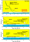
Figure 5. Sea level models proposed for the Port au Choix region.
The second new model is a modification of the type-B sea level history in that the late Holocene record is punctuated by a brief sea level oscillation above present between ~3500 and 2000 b.p. This model is postulated based on the occurrence of a fossil sea cliff which lies just above present tide level along the west coast of the peninsula (cf. Grant 1994).
Integrating Archaeology And Sea Level History
We decided that all three sea level models warranted further investigation. We superimposed archaeological sites of known age and elevation on the three sea level curves to see what pattern, if any, might emerge. By superimposing known site locations on the modified type-B sea level curve we discovered that, according to this model, Groswater and Dorset Palaeoeskimo sites would have been located 9-10 m asl at the time of occupation, whereas the MAI cemetery would have been at least 14-15 m asl, during its active phase. This would imply that the cemetery was placed on higher ground, and that any MAI settlements would likely have been located closer to the active beach (possibly within 10 m using the elevation of Palaeoeskimo sites as a guide); today these would be at, or below, present sea level. Comparison of the same site data with the type-A and type-B sea level curves revealed no consistent pattern of site elevation above the sea level and suggested that perhaps factors other than sea level were important in site selection by all cultural groups at Port au Choix. Regardless of the outcome, this exercise impressed on us the need to test empirically the assumption that the elevation of the MAI cemetery was a guide to 4500 b.p. sea level position.
Testing Our Ideas: The 1996 Field Season
In the summer of 1996 we set out to investigate further the relationship of archaeological sites and sea level history, using a two-pronged approach. First, we wanted to test the three proposed sea level models by means of empirical sea level reconstruction. Two coastal ponds were selected for coring in the Port au Choix region; coring was done in spring 1997, and relevant analyses are ongoing. Second, we wanted to conduct a new kind of archaeological survey that would allow us to cover a broad area of the town, in order to find any traces of MAI settlement.
We concluded that the most efficient way to conduct a broad survey of the entire town would be to take advantage of the fact that many residents had come across archaeological material in their day-to-day activities, by virtue of the widespread occurrence of archaeological sites throughout the main townsite. We decided to map systematically the presence and absence of non-mortuary MAI material in people’s archaeological collections. We conducted informal interviews (kitchen-table conversations) with residents, asking about any archaeological material that they might have uncovered in the course of building their house or wharf, or as they dug their garden, or when they were out on the land, walking, hunting, fishing, etc. In particular, we wanted to see if people had recovered any MAI artifacts from the modern beach or as they fished in the shallow water offshore.
We plotted this information on a 1:2,500 scale community map and an enlarged aerial photograph of the town. The interviews enabled us to eliminate from further consideration large areas of the town where there were no MAI finds of any sort. Meanwhile, possible MAI material showed up in two locations in the southeast edge of the town at the 8-10 m level. One homeowner showed us the blade of a large Ramah chert projectile point (Fig. 6) that was found when his parents’ basement had been excavated many years ago. The blade was similar in proportions to material from the MAI graveyard site in southern Labrador, thought to date to around 5000-4000 b.p. (McGhee and Tuck 1975:221).
Recent excavation of a nearby house foundation on the same 8-10 m level turned up a large amount of toolmaking debris, first noticed by the owners when they began to landscape. Although the flakes themselves were culturally undiagnostic, they were clearly not Palaeoeskimo in origin. We could tell this because the material was not the fine-grained Cow Head cherts from the Cow Head Formation, located 50-70 km farther south on the Northern Peninsula, which were almost exclusively used by both the Groswater and Dorset Palaeoeskimo people who occupied Port au Choix. Thus, by process of elimination we concluded that the flakes were prehistoric Indian; however, there was no way to differentiate MAI from Recent Indian. The single artifact associated with the flakes was a bipointed biface (Fig. 7) which, although rather generic in form, has parallels in the MAI material from the Beaches site in northeastern Newfoundland dated to between 4900 ± 230 b.p. (SI-1384) and 3840 ± 40 B.P. (I-7509) (Carignan 1975: 203).
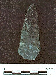
Figure 6. Ramah chert blade from a homeowner’s basement.
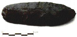
Figure 7. Chert biface from homeowner’s basement.
The coincidental occurrence of the two possible non-mortuary MAI finds in the same area of town at approximately the same elevation prompted further investigation. From aerial photographs and ground surveys we could roughly trace this 8-10 m level for over a kilometre as it curved through the southeastern edge of town, terminating in bedrock cliffs at either end above Back Arm and Gargamelle Cove (Fig. 2). Four 1 m2 (sterile) test pits on this level revealed a thick peat cover (up to 1.5 m) over a variable substrate which ranged from pebble beach gravel to weathered limestone. Also, a heavy growth of tuckamore (often impenetrable thickets of dwarfed trees, commonly larch and alder) obscured the underlying terrain, except in limited areas where the beach gravel had been quarried or the land had been cleared.
Refining Our Approach
A combination of preliminary results from the sea level research, which strongly suggested a type-A sea level history for the Port au Choix region, and the distribution of non-mortuary MAI finds at the 8-10 m level focussed our attention on this elevation in the southeast end of town; ironically, this had been one of the main areas targeted in our 1990 survey. Given the practical difficulties of digging test pits in such overgrown and peat-covered terrain it was necessary to narrow down the areas of highest potential. We therefore refined our earlier list of MAI site selection criteria (Table 2).
By virtue of its location in the southeast end of town, the study site would have been located on the “mainland” during higher sea levels at approximately 4000 b.p. Anywhere along the 8-10 m level would have provided access to both inland and ocean, a view of the cemetery on the nearby island, and a sheltered location protected by higher ground inland and an island offshore. We therefore focussed on micro-components of settlement location. As we noted before, access to fresh water would have been important, along with a gently-sloping foreshore good for landing boats. We predicted that a broad flat terrace would have been preferable for living on rather than irregular topography, and that pebble gravel or weathered limestone would have been a more suitable substrate for comfortable living, as opposed to deep beach sand, into which the MAI graves had been dug. One area in particular on the 8-10 m level fulfilled all these criteria and during our 1997 field season this broad, flat terrace became one of our main areas of attention (Fig. 2).
Testing the Approach: The 1997 Field Season
The objective of the 1997 field season was to retest the entire southeast area of town between 6 and 10 m asl for the presence or absence of MAI non-mortuary material. If our results were negative, the next step would be to review the assumptions of our settlement location model, adjust our site selection criteria, and test our revised model in a future field season.
Because of the thick layer of peat, as well as areas of tuckamore, we decided that test pits would not be effective and instead opted for 1 m x 5 m test trenches. Although most test trenches were randomly placed, we were careful to get a good distribution where the 8-10 m level broadened into a large flat terrace.
Our first trench (Boyd Area – Trench 1) was placed at the edge of the broad terrace at 8-10 m asl near the outflow of a small pond, on the other side of the Boyd property. We extended the trench to 15 m (roughly) east-west and 5 m north-south (Boyd Area – Trench 2), finding a well-formed hearth (Boyd Area – Feature 3) (Fig. 8) and a single chert flake similar to those found on the other side of the fence.
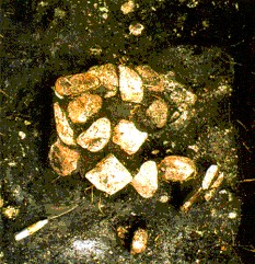
Figure 8. Boyd Area – Feature 3 (hearth).
Not knowing if the hearth was MAI or Recent Indian we spread out from this area, excavating in tuckamore, at the edges of a gravel pit, in areas of tangled heath vegetation and scrub spruce, and in a number of backyards where people had cleared the scrub and removed the top 50 cm of peat. There was many an occasion when we needed to remind ourselves of the value of negative evidence during the 20 days it took us to excavate 46 trenches (Fig. 9), totaling 260m2, all of which came up empty. Now and then we would find a single chert flake of a type that we were attributing to prehistoric Indian, which would tantalize us with evidence of prehistoric occupation somewhere in the area and rekindle our hopes with every new trench opened. We regularly found many weathered limestone rocks lying on top of the bedrock, but since these were part of the limestone substrate (Fig. 10), and since they make unsuitable hearth rocks, we considered them non-cultural although we noted their ubiquity.
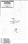
Figure 9. Location of 1 x 5 m test trenches on the 6-8 m and 8-10 m levels at the southeast edge of Port au Choix.
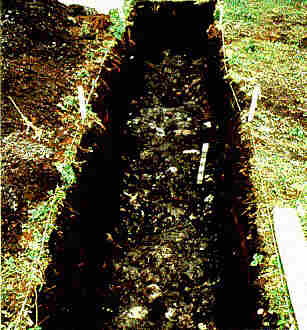
Figure 10. Weathered limestone rocks in trench.
Table 2. List of variables considered important in the choice of location for Maritime Archaic habitation site(s) at Port au Choix.
| Relative sea level | MAI were marine-oriented and likely occupied sites within easy access of the sea; during MAI occupancy both peninsulas at Port au Choix formed a single island and the southeast end of town was a coastal “mainland” location |
| Accessibility to resources | MAI subsistence was oriented towards both terrestrial and marine resources, therefore MAI would likely choose a central location for a base camp |
| Sheltered location | MAI preferred sheltered sites for habitation, for example an area sheltered by topography and offshore islands |
| Open water viewshed | MAI likely chose sites with a view of open water in as many directions as possible, eg. through what is today Back Arm and Gargamelle Cove |
| View of cemetery | MAI may have desired a view of the cemetery |
| Access to freshwater | MAI would have needed drinking water, eg. ponds, streams and springs |
| Coastal access | MAI may have used dugout canoes, which would have been easiest to beach by pulling them up a gently-sloping foreshore |
| Local topography | A flat terrace is a more comfortable place to live than a narrow ridge or irregular terrain |
| Suitable substrate | MAI used deep beach sand for the cemetery but likely would have chosen to live on a more comfortable gravel or weathered limestone substrate |
On the 21st day of digging we found a concentration of flakes in a trench on the 8-10 m broad, flat terrace (Gould Area – Trench 1). When we expanded this into a cross-trench we uncovered another well-formed hearth (Gould Area – Feature 2) (Fig. 11). While this was all very exciting, at this point there was still no way to distinguish between a MAI and Recent Indian hearth. This issue was soon resolved when 2.5 m away in the same trench we found a pile of 36 small white quartz pebbles, similar to those found by the hundreds in a number of the MAI graves (Fig. 12). These pebbles were associated with a small piece of red ochre, as well as a pile of what appeared to be unburned cut bone (Gould Area – Feature 1); this pile was removed as a block and will be excavated in the M.U.N. Archaeology Unit prehistory lab. The next day our conclusions were substantiated when we found two MAI ground slate gouges (Fig. 13) approximately 9 m southwest of the hearth (Gould Area – Trench 10). We knew that we had located a Maritime Archaic Indian site and we called it the Gould Site (EeBi-42).
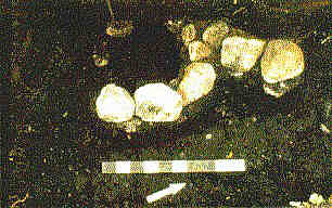
Figure 11. Gould Area – Feature 2 (hearth).
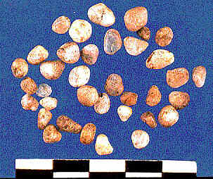
Figure 12. Small quartz pebbles from Gould Area.
We were also able to trace the site’s extent. We had begun to notice that the weathered limestone rocks, although common, were not ubiquitous as we had originally thought. In several trenches situated well back, some on narrow ridges, others at the edge of a small pond, we did not find any weathered limestone rocks. Also, the second hearth, which was formed of large, heavy, fire-reddened granitic cobbles like the first, was associated with white weathered limestone rocks which had obviously been heated as a result of proximity to the fire. In other words, the weathering was the result of cultural activity. When we traced the distribution of the weathered rocks we found that it was limited to the broad flat terrace at 8-10 m asl, covering an area of approximately 1.8 ha (Fig. 14). As expected, the MAI settlement is extensive, although at this point we cannot tell how intensive and continuous is the cultural activity over that large area.
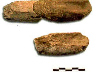
Figure 13. Gouges from Gould Area – Trench 10.
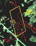
Figure 14. Extent of Gould Site. Four houses on the site are highlighted in yellow.
Radiocarbon dates on charcoal from the two hearths establish the contemporeneity of this site with the MAI cemetery (Table 1). The first hearth (Boyd Area – Feature 3) returned a date of 3740 ± 50 b.p. (Beta-107795) and the second (Gould Area – Feature 2) is dated at 3270 ± 50 b.p. (Beta-108099). These compare with the range of cemetery dates between 4290 ± 110 b.p. and 3410 ± 100 b.p. It remains to future excavations at the Gould site to esablish whether or not it overlaps in time with the earliest use of the cemetery.
Possible Recent Indian Component
Meanwhile, we found a well-formed hearth suspended in the peat layer of Gould Area – Trench 13. This hearth (Gould Area – Feature 3) was associated with a tip fragment of a projectile point or biface; however because the tip was sharp, it was most likely the former. The chert was light tan, almost weathered-looking, and had microscopic black radiolari as well as larger square, rectangular, and trapezoidal holes made by leached-out mineral inclusions. Because this was not the distinctive Cow Head chert that the Palaeoeskimo used at Port au Choix, and neither was it tip-fluted [2], our preliminary conclusion is that it is prehistoric Indian. Charcoal from the hearth was radiocarbon dated to 1520 ± 60 b.p. (Beta-108552), which places it in the Recent Indian time period, overlapping with dates from Dorset sites at Port au Choix (Renouf 1991).
Epilogue
The integration of the archaeology and sea level history was successfully applied at Port au Choix where the coastline was important for prehistoric settlement and where an understanding of Holocene sea level history was therefore crucial. As a result of this integration we were able to locate a long searched-for, and well-concealed MAI habitation site. No wonder the site had remained hidden for so long. It is covered by 1.5 m of peat as well as stands of dense tuckamore (Fig. 15).
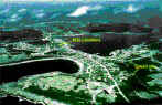
Figure 15. Aerial view of Port au Choix showing location of the MAI Gould Site in relation to the cemetery site.
It remains for us to establish the site stratigraphy and chronology, to establish the density of occupation over this large area, and to proceed with excavation of key areas. There is the potential for good bone preservation, given the limestone bedrock of the Port au Choix area, and the find of a few pieces of cut bone is promising. We hope to find evidence of dwelling structures, activities areas, and middens; in other words, evidence of everday life, including preparations to bury the dead. Establishing these fundamentals is basic to understanding many outstanding issues regarding the MAI culture in Labrador, Newfoundland and points south. With the discovery of the Gould site we are now in a position to establish some of these basics which, together with the information from the associated cemetery, will provide us with a fuller picture of this culture than has been available to date.
Notes:
1. b.p. = radiocarbon years before present
2. A characteristic of Dorset endblades in Newfoundland.
Reference
Anderson, J.E.
1976 – “The Human Skeletons,” in J.A. Tuck, Ancient Peoples of Port au Choix. Newfoundland Social and Economic Studies, No. 17. Institute for Social and Economic Research, Memorial University of Newfoundland, St. John’s.
Austin, S.J.
1980 – “Cape Cove Beach (DhAi-5,6,7), Newfoundland: Prehistoric Cultures.” Unpublished M.A. thesis, Department of Anthropology, Memorial University of Newfoundland, St. John’s.
Carignan, P.
1975 – The Beaches: A Multicomponent Habitation Site in Bonavista Bay. Archaeological Survey of Canada, Mercury Series, No. 39. Ottawa: National Museums of Canada.
Evans, Helen
1991 – “Stress Indicators of an Archaic Indian Population: An Examination of Growth Recovery Lines in Skeletal Material from Port au Choix, Newfoundland.” Unpublished B.A.(Hons.) dissertation, Department of Anthropology, Memorial University of Newfoundland, St. John’s.
Fitzhugh, W.W.
1972 – Environmental Archaeology and Cultural Systems in Hamilton Inlet, Labrador. Smithsonian Contributions to Anthropology, No. 16. Washington, D.C.
Grant, Douglas R.
1972 – “Postglacial Emergence of Northern Newfoundland,” in Report of Activities, Part B, Geological Survey of Canada, Paper 72-1B. Ottawa: Geological Survey of Canada, 100-102.
1992 – “Quaternary Geology of the St. Anthony-Blanc Sablon Area, Newfoundland and Quebec.” Geological Survey of Canada, Memoir 427. Ottawa: Geological Survey of Canada.
1994 – “Quaternary Geology of Port Saunders Map Area, Newfoundland.” Geological Survey of Canada, Paper 91-20. Ottawa: Geological Survey of Canada.
Harp, E.
1951 – “An Archaeological Survey in the Strait of Belle Isle Area.” American Antiquity 16:203-220.
1963 – “Evidence of Boreal Archaic Culture in Southern Labrador and Newfoundland.” National Museum of Canada, Bulletin 193. Ottawa: National Museum of Canada.
1964 – “The Cultural Affinities of the Newfoundland Dorset Eskimo.” National Museum of Canada, Bulletin 200. Ottawa: National Museum of Canada.
Harp, E and D.R. Hughes.
1968 – “Five Prehistoric Burials from Port au Choix.” Polar Notes 8:1-14.
Jerkic, Sonja
1993 – “Burials and Bones: A Summary of Burial Patterns and Human Skeletal Research in Newfoundland and Labrador.” Newfoundland Studies 9:213-234.
Kaland, P.E., K. Krzywinski, and B. Stabell
1984 – “Radiocarbon-dating of Transitions Between Marine and Lacustrine Sediments and Their Relation to the Development of the Great Lakes.” Boreas 13:243-258.
Kennedy, Brenda V.
1981 – “Marriage Patterns in an Archaic Population: A Study of Skeletal Remains from Port au Choix, Newfoundland.” Archaeological Survey of Canada, Mercury Series, No. 104. Ottawa: National Museums of Canada.
1987 – “A Possible Case of Histiocytosis X in an Archaic Indian from Port au Choix, Newfoundland.” Canadian Journal of Archaeology 11:109-118.
Lie, S.E., B. Stabell, and J. Mangerud
1983 – “Diatom Stratigraphy Related to Late Weischelian Sea-level Changes in Sunmore, Western Norway.” Nor. Geol. Unders. 380:203-219.
Marshall, Kim
1990 – “Patterns of Activity in a Maritime Archaic Population in Newfoundland Derived from Observations of Activity-Induced Degenerative Joint Disease.” Unpublished B.A.(Hons.) dissertation, Department of Anthropology, Memorial University of Newfoundland, St. John’s.
McGhee, R.J. and J.A. Tuck
1975 – “An Archaic Sequence from the Strait of Belle Isle, Labrador.” Archaeological Survey of Canada. Mercury Series, No. 34. Ottawa: National Museums of Canada.
Pastore, R.T.
1986 – “The Spatial Distribution of Late Palaeo-Eskimo Sites on the Island of Newfoundland.” Palaeo-Eskimo Cultures in Newfoundland, Labrador and Ungava. Reports in Archaeology 1:125-134.
Pfeiffer, Susan
1977 – “The Skeletal Biology of Archaic Populations of the Great Lakes Region.” Archaeological Survey of Canada, Mercury Series, No. 64. Ottawa: National Museums of Canada.
Quinlan G. and C. Beaumont
1981 – “The Deglaciation of Atlantic Canada as Reconstructed from the Postglacial Relative Sea Level Record.” Canadian Journal of Earth Sciences 19:2232-2246.
Reader, David
1990 – “An Examination of Molar Attrition, Mandibular Torus, and Temporo-mandibular Joint Arthritis: Their Relations and Cultural and Genetic Affiliations in a Maritime Archaic and Thule Skeletal Group.” Unpublished B.A.(Hons.) dissertation, Department of Anthropology, Memorial University of Newfoundland.
1996 – “‘Interior’ Occupation: A Maritime Archaic Site at South Brook Park, Western Newfoundland.” Canadian Journal of Archaeology 20:123-128.
Renouf, M.A.P.
1985 – “Archaeology at the Port au Choix National Historic Park: Report of 1984 Field Activities.” Unpublished report on file at Archaeology Division, Parks Canada, Atlantic Region, Halifax.
1986 – “Report of 1985 Excavations at the Point Riche and Phillip’s Garden Sites, Port au Choix National Historic Park.” Unpublished report on file at Archaeology Division, Parks Canada, Atlantic Region, Halifax.
1987 – “Archaeological Investigations at the Port au Choix National Historic Park: Report of 1986 Field Activities.” Unpublished report on file at Archaeology Division, Parks Canada, Atlantic Region, Halifax.
1991 – “Archaeological Investigations at the Port au Choix National Historic Park: Report of 1990 Field Activities.” Unpublished report on file at Archaeology Division, Parks Canada, Atlantic Region, Halifax.
1992 – “The 1991 Archaeological Field Season at the Port au Choix National Historic Park.” Unpublished report on file at Archaeology Division, Parks Canada, Atlantic Region, Halifax.
1993 – “The 1992 Archaeological Field Season at the Port au Choix National Historic Park: Report of Archaeological Investigations.” Unpublished report on file at Archaeology Division, Parks Canada, Atlantic Region, Halifax.
Stabell, B.
1987 – “Changes in Diatom Floras in Late Quaternary Western and Southeastern Norwegian Marine and Freshwater Sediments: Response to Basin Isolation from the Sea.” Nova Hedwigia 44:305-326.
Stopp, Marianne P.
1997 – “Long-Term Coastal Occupancy between Cape Charles and Trunmore Bay, Labrador.” Arctic 50:119-137.
Tuck, J.A.
1970 – “An Archaic Indian Cemetery at Port au Choix, Newfoundland.” American Antiquity 36:343-358.
1976 – Ancient Peoples of Port au Choix, Newfoundland. Institute of Social and Economic Research, Social and Economic Studies, No. 17. St. John’s: Memorial University of Newfoundland.
Wintemberg, W.
1939 – “Eskimo Sites of the Dorset Culture in Newfoundland.” American Antiquity 5(4):309-333.