
Archaeology in Newfoundland and Labrador 1997
Edited by K. Nelmes
Preliminary Report on a Site Visit to St. Lunaire-Griquet, August 18 & 19, 1997
Ken Reynolds
Based on correspondence in 1997, from Mr. Gerald Hillier, mayor of St. Lunaire-Griquet, to the Office of the Premier, in reference to artifacts discovered in a sod house outside St. Lunaire, the Department of Tourism, Culture & Recreation was notified.
On Monday August 18th I drove to St. Lunaire-Griquet to investigate the findings. On arriving I met with Mayor Hillier who introduced me to an employee of the town council, and the man who had recovered the artifacts from the sod house. That evening I met with the latter and was shown the artifacts in his possession. The collection consisted nearly entirely of iron objects, mainly wrought iron nail fragments, a possible pin for closing a cloak, a door hinge, what appears to be stove parts and a few unidentifiable pieces. One pipe stem fragment and a few pieces of wood, possibly the remains of posts used in the house construction, were also present. These artifacts appear to represent a late 18th century to early 19th century occupation.
This man located the site on a 1:50,000 scale topographic map; the location he pointed out was a known site, EiAu-2 (Irish Rock). This site was first investigated by Dr. J.A. Tuck in the early 1970s. In July of 1984 the site was revisited and partially excavated by archaeologist Reginald Auger. Auger recovered ten (10) nails, fragments of clear glass, some wood and a possible flint from both test pits and a trench. No ceramics, which would be a great help in dating the site, were found by Mr. Auger.
The collection in the possession of the town council employee also did not contain ceramics which is puzzling. Based on the premise that the area was very damp, Mr. Auger proposed a winter sod house occupied by the Labrador Inuit. Based on my investigation and a later conversation with Dr. Tuck, the possibility exists that this site may represent a winter sealing house occupied by Europeans. Its appearance reminded me greatly of fishermen’s sod foundation “tilts” that I had encountered during a survey of southern Labrador in 1992.
On Tuesday August 19th, I accompanied the man to the site at Back Cove (Figure 1). On the way there I was shown the “Irish Rock” (Figure 2). This is a fairly large bedrock erratic which had two small areas on its surface where man-made inscriptions could be clearly seen. This is an interesting artifact and its decoding would be a significant historical achievement.
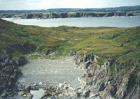
Figure 1. Close-up of Back Cove, looking southwest. EiAu-2 is near the trees in the far right; Granchain Island is in the background.
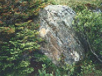
Figure 2. The “Irish Rock,” St. Lunaire-Griquet. The white patch has one set of distinctly man-made etches on it. The second set is found on the face of the stone which is covered by trees.
On arrival I proceeded to photograph the area and then reopened the pits that had been excavated. These totalled five holes within the confines of the structure. One was on a noticeable rise near the end of the house from which many fairly large rocks were protruding above the surface; this may have been the hearth area. The other four were in the walls of the structure. Some of Auger’s/Tuck’s test areas could also be clearly seen. Two nail fragments and some wood fragments were discovered in two separate pits, but were not collected. The stratigraphy consisted of a thick black peat whose texture was damp but not overly so. Sterile subsoil or bedrock was not reached in any of the pits excavated by the town employee, and one large rock had blocked further digging in the house interior. The holes dug into the walls of the house were rock-free, with the exception of one hole just north of the entrance.
No new test pits were excavated within the house as this would have damaged what remains of the structure’s integrity. Further random testing would have yielded little in the way of new information regarding the site’s makers, its season(s) of habitation, or the length of its occupancy.
About four metres north of EiAu-2 was a second area where the man had dug three holes in what he thought was a second house feature. I reopened two of his excavations, in which he had found many artifacts including the possible cloak pin and the pipe stem fragment. The humus layer differed in this area from EiAu-2; the black peat was more difficult to dig through as it was shallower and had more rocks in it. I was given the impression from this cursory investigation that this was an area where the inhabitants of the EiAu-2 cut the sods to construct their house. Of note in this area was a small rise similar to the suspected hearth area in the house. One hole had been dug to a depth of 22 cm below the surface where the accumulation of rocks prevented further digging. Its similarities to the aforementioned feature raises the possibility that there was a house in this area which may have been scavenged to build its neighbour.
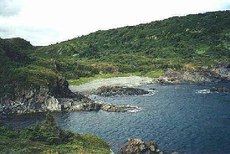
Figure 3. Cow Cove looking southwest. The area around the beach was tested; nothing was found.
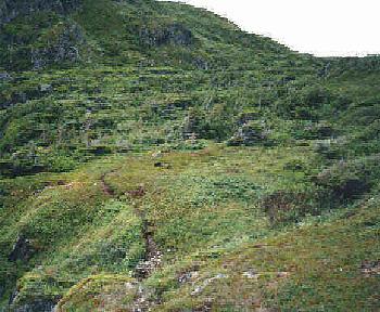
Figure 4. Tested area in crowberry patch, Cow Cove, looking southwest.
Following our examination of Back Cove the two of us walked to the next cove north, Cow Cove (Figure 3). This cove is slightly larger than Back Cove and as with the previous cove, is open to a north east wind. The terrain rises behind a fairly long but shallow storm beach and a small stream enters the sea from its southwest corner. Five test pits were excavated at various grassy spots along the storm beach’s length; all were sterile. A visual inspection of the stream bank and eroding banks also proved negative. A sixth test pit was excavated on a high flat crowberry covered terrace overlooking the beach to the southwest (Figure 4); this also proved negative.
Based on this investigation the potential for historic resources to be located in Cow Cove would seem unlikely. The only possible areas would be the forested spots slightly up from the beach, and these would seem to have only a low potential.
To conclude, the site at Back Cove, EiAu-2, is an interesting feature that could use further archaeological work to ascertain its cultural affinity and time/length of occupancy. However, this should only be undertaken in regard to other similar sites that may be in the area. An archaeological survey of some of this area was undertaken by Reginald Auger in 1984. The area covered selected coves, islands and headlands from Square Bay (south of the community of Great Brehat) to Boat Harbour/Cape Norman to the northwest. The head of Pistolet Bay was excluded from this survey as was most of St. Lunaire Bay. The majority of sites that Auger found were on or near Quirpon Island and it should be noted that he was looking for Labrador Inuit sites, so he did not report all the sites of European origin that he found.
If the Town Council of St. Lunaire-Griquet were interested in having an archaeological survey carried out, the area to concentrate on would be between Northwest Bay and Southwest Bay. The majority of residents of the community would need to be in favour of such a survey as much of the testing, would by necessity, have to be undertaken on private land. This area’s archaeological potential would seem to lie most greatly with the French occupation of the Great Northern Peninsula. Peripheral, but also important sites, would relate to the subsequent English settlement, the possible Inuit occupation of the area and prehistoric Eskimo and Indian habitation in the region. Of note is the finding of Dorset Eskimo artifacts in St. Lunaire in 1969.
Prior to any archaeology work in the area it would perhaps be to the benefit of the St. Lunaire-Griquet Town Council to initiate a program whereby community members are questioned on their knowledge of sites in the area, the location of such, and what, if anything, was found there.
In conclusion the Culture and Heritage Division will, within its means, assist the town of St. Lunaire-Griquet whenever possible.