
Archaeology in Newfoundland and Labrador 1997
Edited by K. Nelmes
In the Eagle’s Nest: Archaeological Investigations in the Mistassini Lake Area, Upper Eagle River, South-Central Labrador
Frederick A. Schwarz
Introduction
The Akamiuapishku Archaeological Project was undertaken by Innu Nation under contract to Parks Canada in September and October of 1997 as Phase I of an archaeological survey and inventory of Akamiuapishku Proposed National Park, central Labrador (Figure 1). The overall objectives of the project were to initiate archaeological survey and to inventory cultural and historic resources within the proposed park boundaries.
The Study Area selected to initiate this inventory was the area around Mistassini, at the headwaters of the Eagle River, near the southern boundary of the proposed park.
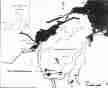
Figure 1. Akamiuapishku Proposed National Park, indicating the location of the 1997 Archaeological Study Area.
Cultural and Historical Background
Ethnohistory:
Historical accounts of close contact between Innu and Europeans in the form of the fur trade began in earnest with the establishment of the Postes du Roy and the Seigneurie de Mingan in the mid-17th century. The 18th century saw expansion of the French fur trade posts eastward along the St. Lawrence to Blanc Sablon and, later, the expansion of English fishing, sealing and trading establishments on the south Labrador coast. For our purposes, these records (for summaries, see Tanner 1977; Loring 1992; Zimmerly 1975) do little more than attest to the growing involvement in the fur trade of Innu travelling to the coastal margins of the southeastern Labrador interior. It is clear that the study area belonged to the interior hunting and trapping grounds of these Innu, and that they spent most of each year moving through, and hunting and trapping in this area. Throughout this period, though, the interior remained remote and unknown to European eyes. Despite its long history, this fur trade only reached its peak of development by the early 19th century, and by the end of the century was already being eroded by encroachment of white trappers from the Labrador coast and Hamilton Inlet (Tanner 1977).
Innu land-use data pertaining to this century have been collected in some detail (Tanner 1977; Armitage 1990; Mailhot 1993; Innu Nation 1994) and are widely available, at least in outline. Tanner notes that families traditionally operating around the headwaters of the Eagle, Kenemich, St. Augustin and St. Paul Rivers tended to trade at a number of coastal locations, principally North West River, but also St. Augustin and, until the 1940s, Sandwich Bay. Families would travel to the plateau area via Kenamu River from North West River in August, move north into the Mealy Mountains to hunt caribou in fall and spend the winter dispersed across the plateau. Some might travel to North West River or St. Augustin for Christmas. Spring saw families gather to fish and hunt waterfowl on the Plateau before returning to the coast in summer. This pattern continued through the first half of this century, though with more and more time spent on the coast, until the requirement to keep children in school at North West River limited family movements to the immediate hinterland of Lake Melville. In 1973, with the development of the Outpost Program, families began travelling seasonally to the plateau once again, this time by air. Favoured destinations are now Iatuekupau and the Mistassini area, and winter/spring are presently the seasons of most intensive occupation.
Archaeology:
The basic archaeological sequence for the region was developed by William Fitzhugh, during his initial research in Labrador in the late 1960s and early 1970s (Fitzhugh 1972; 1975; 1977; 1978a; 1978b). His sequences for Groswater Bay and North West River have provided the basic culture-historical and culture-processual framework for all subsequent archaeological work in Labrador north of the Strait of Belle Isle, and since most of the research subsequently undertaken by Fitzhugh and his associates has focused on coastal regions to the north, it remains the definitive sequence for east-central Labrador to this day.
The earliest well-defined human occupation in Hamilton Inlet dates to the Maritime Archaic period. Maritime Archaic sites in the region were identified only at the eastern end of Hamilton Inlet, on the northern shore of Groswater Bay. Hamilton Inlet Maritime Archaic was initially divided into two phases (Fitzhugh 1972); the earlier Sandy Cove Complex was identified principally at the large site at Sandy Cove, dated by radiocarbon assays and by site elevation (45′-52′) to the period 6000-4700 B.P; the later Rattlers Bight Complex, identified at the type-site at Rattlers Bight, was similarly dated by elevation and radiocarbon dating to 4000-3800 B.P. Subsequently, this sequence has been modified somewhat. The Sandy Cove Complex has been more precisely (if not more accurately) dated to 5200-4500 B.P. (Fitzhugh 1978a:89). Rattlers Bight retains its culture-historical position, but the archaeology of this site has been considerably augmented by the discovery of a cemetery site (Fitzhugh 1978a:85) and by the retrospective identification of “longhouse” structures at the site. In addition, a third, intrusive, Archaic occupation, the Black Island Complex, was defined and dated to the period 4500-4100 B.P. (Fitzhugh 1975).
The subsequent Intermediate Indian period is best known from sites around the present community of North West River, at the western end of Hamilton Inlet. Though the sites there postdate the Maritime Archaic occupations of the outer bay, their elevations are higher (up to 78′), indicating a faster rate of post-glacial rebound in this area, presumably due to its proximity to the western centres of glaciation. The Intermediate Indian period was initially divided into six phases, dated on the basis of site elevation, typological relationships, and a few radiocarbon dates (Fitzhugh 1972:114-116). Two of these phases, the Brinex Complex (3200-3000 B.P.) and the Charles Complex (3000-2700 B.P.), have subsequently been identified at other sites on the Labrador coast, and though Intermediate Indian culture history has been refined since, these must be considered well-defined culture-historical units (Nagle 1978). The North West River Phase (1800-1400 B.P.) is well-defined in Hamilton Inlet, but its culture-historical placement has become increasingly problematic (see Loring 1983; 1985, 1989b). The three remaining phases, the Little Lake Component (3600-3200 B.P.), the Road Component (2700-2300 B.P.) and the David Michelin Complex (2300-1800 B.P.) are poorly-defined and poorly dated, and their validity as culture-historical units is debatable. In general, Intermediate Indian components are characterized by a variety of biface and scraper forms, expedient tools and in some cases, linear-flake/core technology. Raw materials include quartzites, some quartz, and, particularly on northern sites, fine-grained colourful cherts. Partly contemporary with the Intermediate Indian occupations at North West River is a Groswater Dorset occupation of outer Groswater Bay, dated 2800-2100 B.P. (Fitzhugh 1972).
The final prehistoric Indian occupation in the region dates to the Recent Indian period and is represented by a single phase, the Point Revenge Complex (ca. 1400-500 B.P.). As with the Charles and Brinex complexes, Point Revenge has since been recognised as a widespread culture-historical unit, with numerous sites identified in coastal and interior regions. Lithic tools are distinctive and diagnostic, and almost invariably fashioned of Ramah chert. Once again, further work has led to some refinements in the definition and dating of this period in Labrador prehistory (see Loring 1983, 1985, 1989).
It is worth noting that while North West River can be regarded as a single large pre-contact site, it is best interpreted as a complex collection of more-or-less spatially-discrete small camps. In fact, more recent work in the area (Thomson 1987, Penney 1988, Schwarz and Schwarz 1997) has revealed that this scatter of small encampments extends along wooded terraces well beyond the originally defined site area. The archaeological visibility of components located outside the present community of North West River is low, and the North West River site complex offers valuable lessons to those of us contemplating further archaeological work in the Labrador interior. Interior occupations may often consist of relatively small, localized components, only occasionally grouped to form larger sites in particularly strategic locations. The recovery of such localized deposits in conditions of generally poor archaeological visibility demands extremely focused and intensive survey methods.
Sites dating to the protohistoric and early historic period in central Labrador were, and still remain, elusive, but later historic aboriginal sites were noted by Fitzhugh; historic Inuit sites (the “Ivuktoke Phase”) appeared to be restricted to the eastern portions of Hamilton Inlet, while historic Innu sites (the “Sesacit Phase”) were concentrated around the western end of Lake Melville and in the neighbouring river valleys (Fitzhugh 1972:116).
Notable features of this sequence include the absence (so far) of definite Maritime Archaic sites at the western end of Lake Melville, possibly due to the persistence of glacial ice in this area. Most notable, though, is the contrast between the North West River (“interior”) and Groswater Bay (“coastal”) sequences. North West River yielded a sequence of Intermediate and Recent Indian occupations, while in Groswater Bay, Indian occupations alternated with periods of Palaeo-Eskimo and Inuit settlement.
Subsequently, Fitzhugh and his associates tended to concentrate their research efforts on the northern and north-central coast of Labrador, and this work adds little to our expectations regarding archaeological resources in the Akamiuapishku Study Area. In particular, the bulk of this work has been focused on outer coastal settings (but see Loring 1979; 1983), where boat access is easy, and archaeological visibility is good. The traditional outer-coastal bias in Labrador archaeological research is a significant impediment to predicting archaeological resource distribution in a primarily inner-coastal and interior setting like the Akamiuapishku Study Area.
Relevant interior surveys in Labrador have been limited, and generally focused on lakes and major waterways. Such surveys have generally been canoe-based, and focused on identifying surface-visible sites and examining surface exposures. Cursory surveys on the former Lake Michikamau (MacLeod 1967; 1968), Petitsikapau, Menihek and Astray Lakes (McCaffrey 1989), Kanairiktok River (McAleese 1992; 1993), Seal Lake (McCaffrey Loring and Fitzhugh 1989), Hunt River (Strong 1930; Fitzhugh 1986), upper Kogaluk River (Biggin and Ryan 1989) and the lower Churchill River (Fitzhugh 1977; Tuck 1981) have established that recent and historic Innu sites are common in the interior, particularly along lakes. Pre-contact material is more scarce, but invariably encountered in these surveys. Pre-contact sites are also often of indeterminate date, though many are attributed to the Intermediate Indian period by default, and a few definite Maritime Archaic occupations have been identified.
More extensive (and intensive) work in more distant portions of Labrador-Ungava, such as Caniapiscau Lake (e.g. Denton 1989) and Indian House Lake (Samson 1978) have established that, though recent and historic sites are the most numerous, pre-contact occupation may have been substantial in some interior regions. Maritime Archaic sites have been identified, at least at Indian House Lake, but the first significant occupations appear to date to the Intermediate Indian period, and the most substantial pre-contact occupation occurs in the Recent Indian period. Variation in the frequencies of lithic raw materials encountered on these sites (including Ramah chert) suggest extensive networks of long-distance trade and travel crisscrossing Labrador-Ungava prior to contact.
As for near-coastal interior hinterlands and inner-bay regions, recent fieldwork conducted in the Voisey’s Bay area in northern Labrador (Labrèche, Schwarz and Hood 1997) has also helped correct somewhat the traditional outer-coastal bias of archaeological work in Labrador. Investigations confirmed the long-standing expectation that formerly-coastal sites do exist on gently-sloping coastal plains and deltas, sometimes several kilometres from the present shoreline, and that with appropriate logistical support and intensive sampling, these sites can be recovered.
Within the study area itself, no formal archaeological investigations have been attempted. The Labrador interior between Hamilton Inlet, the north shore of the St. Lawrence, and the Labrador Sea is virtually an archaeological terra incognita. However, in the spring of 1997, a man from Sheshatshit reported finding a stone pestle and possible Ramah chert flakes at a large traditional campsite near Pepaukamau (Crooks Lake). This find spot lay within the study area defined for the 1997 survey, and certainly provided an encouraging and auspicious start to the year’s work.
In summary, previous archaeological work in Labrador suggests that cultural resources in the Study area may be dominated by evidence for recent and historic Innu encampments. Pre-contact materials seem significantly more scarce in the forested interior, and early contact-period sites are essentially unknown. However, this is arguably a product of casual survey methods, and intensive investigation may be expected to yield pre-contact materials. More specifically, it is anticipated that pre-contact finds encountered in the study area will most likely pertain to the Intermediate and Recent Indian occupations so clearly documented at North West River. With the destruction of the archaeological record in the Michikamau area, the best opportunity for recovering evidence on early large interior spring gathering sites has been lost. Headwater lakes and wetlands such as those found in the study area now offer the most promising opportunity to recover such remains.
Survey Results
The Sites:
Mistassini 1
The Mistassini 1 site is situated on the eastern bank of the southern outflow from Mistassini to the Eagle River. Once one of the principal traditional campsite locations on Mistassini, Mistassini is presently occupied by a cottage, outbuilding and wharf belonging to residents of Goose Bay. No surface-visible traces of Innu occupation remain in the vicinity of the cottage, an area of some 50 m of waterfrontage and 10-15 m deep, which probably corresponds to that of the original Innu campsites. However, behind the cottage, weathered axe-cut stumps and scattered debris (including 1970s pop cans) likely attest to Innu occupation in the relatively recent past. Investigation of this site included excavation of 31 test pits along the lakefrontage, and along a trail swinging south along the river. These revealed undifferentiated brown sandy soils, likely disturbed by flooding and human activity on the site, with some lenses of charcoal, pieces of firecracked rock, and some flecks of calcined bone. One test pit yielded bright (chromed) fishhook fragments and a piece of porcelain 20 cm below surface. No earlier historic or pre-contact remains were encountered.
Mistassini 2
Mistassini 2 is situated on the opposite side of the outflow from Mistassini 1, along the Mistassini lakeshore. Another of the principal traditional campsites on Mistassini, Mistassini 2 is now less frequently used by the Innu, since the construction of the cottage nearby at Mistassini 1. However, surface-visible traces of Innu habitation do remain. Mistassini 2 occupies an area of roughly 500 m2 and consists of several clearings in woods, set back from the shore and screened from the open water by trees. Visible traces include three decayed tent-frames, and two heavy scaffolds used as firewood caches. Two other clearings appear to have been campsite locations as well at one time, though no surface-visible features remain. Though the site appears to have been occupied as recently as the last few decades, there is none of the abundant plastic and cloth debris usually associated with contemporary Innu camps. Thirty-one test pits excavated behind waterfrontage and in clearings revealed good clear soil development horizons under relatively shallow (5-10 cm) duff. Clearly the deposits here are stable and undisturbed, with real archaeological potential. However, no cultural materials were recovered during testing.
Mistassini 3
Mistassini 3 is located on the southern shore of Mistassini, some 300-400 m west of Mistassini 2. Another major Innu encampment on Mistassini, Mistassini 3 occupies an area of some 600 m2. Visible are seven old and empty clearings marking former campsites, three tent-frames with notched wooden stove supports in situ, and one scaffold. Debris observed on the surface includes aluminum cans and plastic debris indicating occupation within the last two decades or so, along with a number of objects which are at least potentially a little older; these include iron stoves, including one made from an oil drum, a circular skin-stretcher, a hand-beaten zinc bowl, square glass medicine bottle, and an enamelled tin washbasin. Like Mistassini 2, Mistassini 3 is set back in the woods and sheltered to the north, indicating cold-season occupation. This interpretation is supported by the presence of an oil drum stove; such stoves are larger and heavier than those made of sheet metal, and according to one informant are associated with winter camps in particular. Twenty test pits excavated in clearings revealed clear soil development profiles, but no cultural remains.
Mistassini 4
The Mistassini 4 site occupies a small point of land at the mouth of the principal stream flowing into Mistassini from the west; the headwaters of this stream lie in the hills flanking the Kenamu River, and so this site lies at the terminus of the main traditional travel route from Sheshatshit to Mistassini. According to another informant, this campsite has not been in use for some 50 years, and certainly there are no surface-visible traces. The site itself is extremely small, consisting of no more than 100 m2 of level, eroding riverbank backed by wet spruce-sphagnum forest. The informant noted that this riverbank is subject to considerable flooding and ice-scouring in spring, and it is possible that much of the traditional occupation area has been eroded. The excavation of 29 test pits confirmed evidence of past flooding, revealing a complex stratigraphy of podsolic profiles and sand lenses, along with charcoal lenses; cultural faunal remains were also recovered, including firecracked rock, calcined bone flecks, and identifiable calcined avian bone. One caribou tooth was also encountered. In an effort to date these indeterminate but potentially historic remains, two 1 m2 units were excavated in this relatively small area. One yielded charcoal and fish bone, probably of no great age, at 5 cm below surface, then a solid layer of charcoal and bone mash below that. The other unit yielded pieces of canvas and tin cans, along with bird bone and a .22 cartridge case in podsoil beneath the duff. None of this is necessarily insonsistent with an age of ± 50 years, though all could also be associated with short-term goose-hunting activites (e.g. boil-ups) in more recent years as well.
Mistassini 5
On Mistassini, sandy beaches are limited to areas at the bottoms of coves, where bog encroaches on open water. One such location is found at the northwest corner of the lake, where two small clearings with high-cut stumps, tent poles, and two green plastic garbage bags were observed in sparse woods at the edge of a vast expanse of bog. The height of the stumps and the poor drainage both indicate that this was a winter campsite, probably of no great age. The narrow sandy beach was closely inspected for flakes, but none were seen.
Mistassini 6
The main contemporary Innu campsite on Mistassini is located on the northern side of the lake, near the outflow leading north to Kamishekemat and the northern branch of Eagle River. This large campsite has obviously been the main focus of Innu settlement on Mistassini since construction of the cabin at the southern outflow. The site itself is 300-400 m west of the outflow, on the nearest dry ground, and extends over some 750 m2 with some 100 m of lake frontage. This area has been extensively cleared, and is very open to the water. Scattered cut stumps extend over an even broader area in woods around the site. Surface visible features are numerous, and appear to be of recent date. These include two standing tent frames, two areas of spruce bough flooring, one low log storage platform, one log-built helicopter landing pad, five open hearths, a children’s play tent, one tentpole cache, and two scaffolds. Debris is abundant, and consists mainly of plastic and metal, indicating recent and continuing deposition, though one carved wooden sled found on-site may be relatively old. While virtually everything observable on the surface appears to date to within the last few years, the centre of the clearing has gone to grasses and herbaceous weeds, an anthropogenic vegetation cover suggesting that this site may have been in use for many years. A total of 77 test pits were excavated along the ice-push ridge fronting the site, in clearings behind the water, and along the trail leading east to the outflow. These revealed intact, often wet soil development profiles underlying very thick (50 cm) peat. One test pit yielded a .22 cartridge case and some recent bird bone in peat.
Kamishekemat 1
Kamishekemat 1 is situated on a south-facing sheltered location on a point of land on the western shore of the lake. The site consists of two tent-frame structures surrounded by small woodcutting areas and cut stumps scattered among trees. Debris is sparse and limited to a few rusted tin cans and wooden objects, including a handmade beaver gaff fabricated from a broken canoe paddle. There is little of the plastic debris usually associated with recent Innu habitation sites, and Kamishekemat 1 has likely not been occupied in recent years. The site location on a prominent point of land, and the relatively large area of level habitable ground, combine to indicate reasonable archaeological potential. Fifteen test pits excavated around the tent frames and in clearings revealed well-defined but wet soil development horizons and yielded no cultural materials.
Kamishekemat 2
Kamishekemat 2 was the main contemporary Innu campsite identified on Kamishekemat. The site is situated on a slightly projecting point of land near the northwest corner of the lake, beside a small, narrow stretch of sandy beach. Unusually, the lakeshore here is backed, not by low-lying spruce-sphagnum forest, but by a gentle slope rising to hills to the north. The site itself is a± 750 m2 area of irregular clearings, quite open to the water, supporting a mixture of grasses, herbaceous weeds, and anthropogenic heath vegetation. Cultural features include three tent frames and numerous empty clearings where camps once stood, tentpole caches, and a cache of stoves. There are also two in-ground fish freezers on the site: one a plywood box set in the ground, the other a hole excavated under tree roots, the opening covered with a row of wooden stakes. As at Kamishekemat 1, debris is scarce, particularly recent plastic debris, though a skidoo parked on the beach appears to be quite recent. Overall, the anthropogenic vegetation suggests regular habitation at the site over a long period, though the scarcity of debris suggests more limited use in recent years. Thirty test pits were excavated in clearings, giving fairly good coverage across the site. These revealed thin, rocky, but very dry soils with shallow but well-defined soil development profiles.
Kuekuatsheupaustuk 1
During the survey of the Upper Eagle River between Mistassini and Meshustun, a stretch of seemingly dry, level riverbank was noted on the western shore, just above a rapids. Although no known Innu campsite was indicated for this location, suitable habitation areas along here are rare enough that this warranted closer inspection. We began test-pitting in a line some 5 m behind the riverbank, and in the ninth, we recovered sherds of porcelain and glass, calcined bone, and fragments of the key and roll from a luncheon meat tin (these last were not collected). All were associated with firecracked rock in a charcoal-rich layer located 15-20 cm below surface in the duff. This find spot was designated Kuekuatsheupaustuk 1. In all, ten test pits were excavated, all revealing strong soil development horizons beneath extremely thick duff. No other units yielded cultural materials. It is likely that this site simply represents a recent boil-up location, and the site was Bordenized largely because cultural material was recovered in subsurface testing. What is interesting about this site is how deep the cultural deposit was, considering that it is unlikely to be more than 20-30 years old, and may well be more recent than that.
Meshustun 1
Meshustun 1 is situated on a point of land at a strategic location between two lakes, Meshustun and Mituauiatshuin. The site lies near one end of the channel leading to Pepaukamau (Crooks Lake), and in fact lies at the junction of three major travel routes leading east along the Eagle River, south to Pepaukamau and the St. Augustin River, and north to Mistassini and the Kenamu River. The site consists of a large (1.17 ha) area that has been cleared for campsites and firewood and is now exposed to the south and west. It was not possible to fully inventory the surface visible cultural features because of 4-6″ of snow cover. However, it is evident that many spruce bough floors are present, along with several tent frames, scaffolds, in-ground freezers, and a boat cache. One fact which compelled us to investigate this location was a report by an informant that a stone pestle and possible Ramah chert flakes had been accidentally uncovered at this site in the spring. Because of the snowcover, we were unable to precisely relocate this original find spot, and had to rely completely on a program of subsurface testing. In all, we excavated 65 test pits across the cleared portion of the site. Subsurface remains were encountered in two loci.
Locus 1
Cultural materials were encountered during testing in the western portion of the occupation area, some 34 m from the water and 4 m above lake level. 368 quartzite flakes were encountered in Test Pit 41, which was enlarged to a 1×1 m unit, in the hope of recovering diagnostic artifacts and further information on the nature of the deposit. Subsequently, 25 quartzite flakes were recovered from Test Pit 45 and one from Test Pit 65 nearby. The 394 flakes recovered in this area range from large pieces of shatter and cortical spalls to fine resharpening flakes, and vary widely in colour, including red-pink, amber, grey, brown, and green. In addition to the flakes, thirteen artifacts were recovered. Most are expedient tools: one flake core fragment, one linear flake/blade core fragment, six linear flakes, and three retouched flakes. However, the collection also includes one fine biface tip, and one crude but complete lanceolate biface. None of these are strictly diagnostic, but comparison of raw material (exclusively quartzite) and general tool types with the North West River collections (Fitzhugh 1972; Nagle 1978) suggests an Intermediate Indian period date of occupation, most likely Brinex Complex or North West River Phase. It must be cautioned, however, that this height-of-land area is archaeologically poorly known, and comparisons with the north shore of the St. Lawrence may be more apt. The suggested Intermediate Indian affiliation is therefore tentative. All cultural materials were recovered within the Ae horizon 15-30 cm below surface. This horizon was lacking in firecracked rock fragments or organic enrichment, though the density of debitage and the diversity of artifacts suggests a habitation area, likely including a hearth, somewhere close by. Locus 1 does not appear to exceed 110 m2 in area.
Locus 2
Locus 2 lies some 50 m southeast of Locus 1 and 17 m from the water at 2 m above lake level. Testing in this area yielded 19 small quartz flakes and one piece of retouched shatter in Test Pit 50; lithics were encountered in an organically-enriched Ae horizon close to the surface at only 5 cm below surface. Twelve metres away, a rectangular blue (“English”) gunflint and pieces of calcined bird bone and firecracked rock were encountered in testing, again in an enriched Ae zone, and once again very close to the surface beneath a recent tent floor. Locus 2 clearly has two components, one contact period, and one pre-contact. The pre-contact component is difficult to date by raw material use; if compared again with Labrador coastal material, a pure quartz assemblage suggests an Early-Middle Maritime Archaic date, but again, the sample is small, and a coastal comparison may not be the most appropriate. In interior Quebec (Samson 1978; Denton 1989) and on the north shore of the St. Lawrence (Chevrier 1978), quartz and quartzite assemblages appear to persist into the Recent Indian period. The contact-period component is similarly hard to date more precisely; gunflints do not appear to be commonly associated with mid-late nineteenth-century Innu sites investigated in the Fort Chimo area (Lee 1966, 1967), Indian House Lake (Samson 1978), or northern and central Labrador (Loring 1992). An eighteenth- or early nineteenth-century date seems most likely at present (see Denton 1994). Locus 2 appears to encompass an area of at least 100 m2.
In summary, Meshustun is a large, strategically located Innu campsite, still very much in use. Archaeologically, the site appears to have at least two pre-contact components, discrete horizontally, and in terms of raw material use patterns; one quartz assemblage, one quartzite assemblage, and, if we include our aforementioned informant’s reported finds, one Ramah assemblage. Dating of these components is still problematic. They may be widely separated in age, or they could even be broadly contemporary. Patterns of raw material use and relationships with assemblages on the coast, interior Quebec and the north shore have yet to be defined, and further work is needed before anything more can be said. In addition, there is an historic component of indefinite but potentially early date. All of these components appear to be in situ and substantially undisturbed, and they likely represent small, discrete campsites. Additional subsurface components may well be present. In short, Meshustun 1 is a large, intact, multi-component historic and pre-contact site.
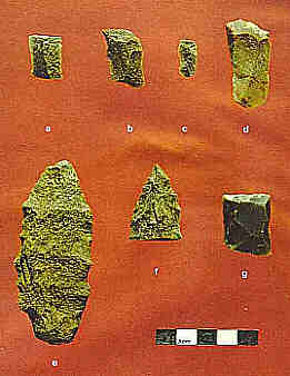
Figure 2. Selected lithic artifacts from Meshustun 1 (FeBu-1): (a-c) Linear flakes/blades, Locus 1; (d) Linear flake core fragment, Locus 1; (e) Biface, Locus 1; (f) Biface tip, Locus 1; (g) Gunflint, Locus 2.
Discussion
This archaeological first look at the Eagle Plateau region, though brief, led to the recording of ten archaeological sites, not counting a host of boil-up sites, portage trails, and other indicators of transitory recent human activity. All the recorded sites consist of recent and contemporary Innu campsites, some of which appear to have been in use for many years. One site contained evidence for earlier historic and pre-contact components.
Pre-Contact/Early Contact Period Components
General Observations:
Before discussing the pre-contact remains encountered during the survey, it is worth making some general observations about the nature of recent Innu campsites, and the implications for pre-contact remains in the Labrador interior. The distribution of recent sites, with a scatter of boil-up sites, and clustered campsite locations, suggests a pattern of land-use creating an extensive veneer of material remains across the study area. In the case of recent sites, these are highly visible, but this contrasts with pre-contact remains in Labrador, which appear considerably more scarce and sparse. Is it possible that the pre-contact settlement was in any way comparable in intensity and distribution with that of the Innu in more recent years? The answer, I believe, is that it is possible. The distribution of recent Innu sites in the study area is in some ways reminiscent of the pattern of pre-contact sites recorded previously on Gambo Pond, on the Island of Newfoundland (Schwarz 1992). There, close pedestrian survey of a relatively small water body led to the recovery of a surprising number of lithic remains – eighteen find spots in all. Two thirds consisted of stray finds, and in fact, every sandy point of land on the lake appeared to yield at least a minimal trace of pre-contact activity. On the basis of site location at least, many of these sites appeared to be functionally redundant. The overall impression was of intensive pre-contact land-use, at least in some periods, in the form of relatively small campsites. In a few instances, small campsites were grouped in particular strategic locations to form large “sites.” In others, they were dispersed across the landscape in discrete, but redundant locations, forming a thin, even veneer of archaeological remains. Though it would be difficult to prove, it would not be surprising if rotation of sites in response to fuel requirements was one factor acting to disperse campsites and archaeological remains, in interior regions of both Newfoundland and Labrador, where interior settlement may be particularly associated with cold-season occupations. Since archaeological visibility is in part a function of site size and artifact density, any factor acting to disperse settlement, even by short distances, will naturally act to reduce archaeological visibility of sites as well. This may therefore partly explain the pattern of remains in the Labrador interior, where pre-contact sites often appear to be small and scarce in comparison to contemporary campsites, which, even in the absence of plastic debris, are readily identifiable by their anthropogenic impacts on vegetation and visible (if ephemeral) organic remains. Given the demonstrably low archaeological visibility of pre-contact interior remains, it is premature to conclude on the basis of site scarcity that past interior settlement was necessarily transient or ephemeral in any or all periods. Indeed, if site rotation did act to disperse settlement in the past as well, then site size may never accurately reflect the nature and relative intensity of interior settlement. None of the foregoing observations are particularly profound, and nor are the conclusions: particularly intensive recovery strategies are needed to document pre-contact interior settlement, and only with data from appropriate surveys can we attempt to accurately assess the nature, culture-history, and relative intensity of interior occupation.
Meshustun 1:
One of the contemporary Innu campsites investigated during the survey yielded evidence for earlier occupation. While many interior sites appear to consist of the remains of small camps, nevertheless sometimes as at North West River, small components may be found concentrated in a single strategic location. Though it is by no means as large as North West River, Meshustun 1 appears to be a site of this type. Testing yielded evidence for two discrete loci, with distinct lithic remains, along with evidence for relatively early historic occupation. In addition, yet another pre-contact component has been reported from this site, and there may be more.
Obviously, on the basis of one site, it is premature to draw conclusions on the distribution of pre-contact remains in the study area, other than noting that the location is a strategic one at the junction of several waterways and major axes of travel. Similarly, site function and seasonality remain to be established, though the constellation of available resources indicates spring as one likely season of occupation; in addition, the site location raises the possibility that Meshustun 1 may have been a gathering site of some sort. Finally, it is difficult yet to determine the culture historical placement of the site, though at least one component most likely dates to one phase of the Intermediate Indian period.
Clearly, a great deal of work is required at Meshustun 1 before we can outline the nature, extent, and chronology of pre-contact occupation at the site. However, the potential for pre-contact remains in the area has now been realized, and there are likely more such sites.
Recommendations
The 1997 survey leads to three general conclusions which must underlie any recommendations for further work on research, interpretation, and cultural resource management.
The first is that pre-contact and elusive early-contact archaeological remains do exist in the Eagle Plateau region, and that these appear to include relatively large, diverse, and multi-component sites. Second, such sites can be recovered in this environment, with use of intensive subsurface testing programs. Third, a strategy of focusing on contemporary Innu campsites can successfully lead to the recovery of such remains, and will aid in identifying higher-potential locations in an area where habitable sites are relatively scarce. Such a strategy is viable, at least for research purposes, though its utility in cultural resource management/impact assessment may be more limited.
Summary and Conclusions
The brief program of archaeological survey conducted on the Eagle Plateau in 1997 represents the beginning of a cultural resource inventory and assessment of Akamiuapishku Proposed National Park. It also represents the first archaeological survey to be undertaken in the plateau region, and indeed, in southeastern interior Labrador. The study area selected for this survey consists of a group of interconnected lakes surrounding Mistassini Lake at the very headwaters of the Eagle River, on the southwestern edge of the Eagle Plateau. This area was selected not only because there was ample evidence for recent and traditional Innu land-use, but because it lies at the junction of long-distance travel routes leading to Lake Melville, the Labrador Sea, and the Côte Nord, a strategic location with potential for significant long-term occupation through the pre-contact and early contact periods.
Survey methodology involved focusing on high-potential locations identified in advance through consideration of available Innu land-use data. Subsurface testing programs were as extensive as time constraints and the environmental conditions would allow, but were thus targeted at pre-identified locations. General boat-based survey of waterways was undertaken, but was limited. In this environmental setting, locations suitable for habitation are limited, and most (though not all) potential site locations have seen Innu settlement in recent years.
During the course of the survey, ten recent/historic Innu campsites were visited and tested. One of these yielded evidence for multiple pre-contact components and also one early historic Innu occupation. Survey results indicate that the method of targeting testing at known traditional campsites can be successful in this setting, at least for research purposes, and that with adequate subsurface testing, early historic and pre-contact components can be identified.
Given that the 1997 survey was relatively brief and precisely targeted, these results indicate that the Eagle Plateau may have considerable archaeological potential. In fact, in this particular area, that potential has now been realized. Not only are early sites present, but they have considerable research potential as well. Henceforth, cultural resource management in this region, whether in the context of the proposed National Park or other outside development, must take account of this potential.
References
Armitage, Peter
1990 – Land Use and Occupancy among the Innu of Utshimassit and Sheshatshit. Report prepared for Innu Nation, Sheshatshit and Utshimassit.
Biggin, M. Scott and A. Bruce Ryan
1989 – “A Reconnaissance Archaeological Survey of the Kogaluk River Area, Labrador.” Report on file, Historic Resources Division, St. John’s.
Chevrier, Daniel
1978 – “La Côte Nord du Saint-Laurent.” Recherches Amerindiennes au Quebec 7(1-2):75-88.
Denton, David
1989 – “La Periode Prehistorique Recente dans la Region de Caniapiscau.” Recherches Amerindiennes au Quebec 19 (2-3):59-75.
1994 – “Des Pointes de Projectile aux Pierres a Briquet: é volution d’une Tradition Technologique du Qué bec Subarctique.” Recherches Amerindiennes au Quebec 24(1-2):73-102.
Fitzhugh, William W.
1972 – Environmental Archaeology and Cultural Systems in Hamilton Inlet, Labrador. Smithsonian Contributions to Anthropology 16, Washington D.C.
1975 – “A Maritime Archaic Sequence from Hamilton Inlet, Labrador.” Arctic Anthropology 12(2):117-138.
1977 – “Indian and Eskimo/Inuit Settlement History in Labrador: An Archaeological View,” in C. Brice-Bennett (ed.), Our Footprints are Everywhere, pp. 1-41. Labrador Inuit Association, Nain.
1978a – Maritime Archaic Cultures of the Central and Northern Labrador Coast.” Arctic Anthropology 15(2): 61-95.
1978b – “Winter Cove 4 and the Point Revenge Occupation of the Central Labrador Coast.” Arctic Anthropology 15(2): 146-174.
1986 – “Maritime Archaic Field Studies in Central Labrador and Notes on North West Corners,” in J.Sproull Thomson and C. Thomson (eds.), Archaeology in Newfoundland and Labrador 1985, Annual Report 6, pp. 54-65. Historic Resources Division, Department of Culture, Recreation and Youth, Government of Newfoundland and Labrador, St. John’s.
Innu Nation
1994 – LAMAP: Volume 1 Covering NTS map sheets for 13A, B, C, D, E, F, G, H. Innu Nation. Sheshatshit, Labrador.
Labrèche, Y., F. Schwarz, and B. Hood
1997 – “Historic Resources Technical Data Report for the Baseline Environmental Assessment of Voisey’s Bay.” Report submitted to Voisey’s Bay Nickel Company Limited, St. John’s.
Lee, Thomas
1966 – “Archaeological Traces at Fort Chimo, Quebec, 1964.” Anthropological Journal of Canada 4: 33-44.
1967 – “The Earth Rings and Other Archaeological Sites at Fort Chimo, 1965,” in Fort Chimo and Payne Lake, Ungava, Archaeology 1965. Travaux Divers (Qué bec) 16. Universite Laval, Qué bec.
Loring, Stephen
1979 – “A Report on an Archaeological Survey of the Palmer and Korok River Valleys for the Torngat Archaeological Project, 3 August – 3 September 1978.” Report on file, Historic Resources Division, St. John’s.
1983 – “An Archaeological Survey of the Inner Bay Region between Nain and Davis Inlet, Labrador: A Report of 1982 Fieldwork,” in J. Sproull Thomson and C. Thomson (eds.), Archaeology in Newfoundland and Labrador 1982, Annual Report 3, pp. 32-56. Historic Resources Division, St. John’s.
1985 – “Archaeological Investigations into the Nature of the Late Prehistoric Indian Population in Labrador: A Report on the 1984 Field Season,” in J. Sproull Thomson and C. Thomson (eds.), Archaeology in Newfoundland and Labrador 1984, Annual Report 5, pp. 122-153. Historic Resources Division, St. John’s.
1989a – “Une Ré serve d’Outils de la Pé riode Intermé diare sur la Côte du Labrador.” Recherches Amerindiennes au Quebec 19 (2-3): 45-57.
1989b – “Tikkoatokak (HdCl-1): A Late Prehistoric Indian Site near Nain,” in C. Thomson and J. Sproull Thomson (eds.), Archaeology in Newfoundland and Labrador 1986, Annual Report 7, pp. 52-71. Historic Resources Division, St. John’s.
1992 – “Princes and Princesses of Ragged Fame: Innu Archaeology and Ethnohistory in Labrador.” Unpublished Ph.D. Thesis, Department of Anthropology, University of Massachusetts.
MacLeod, D.
1967 – “1967 Field Trip Report.” Report on file, Historic Resources Division, St. John’s.
1968 – “1968 Field Trip Report.” Report on file, Historic Resources Division, St. John’s.
Mailhot, José
1993 – Au Pays des Innu: Les Gens de Sheshatshit. Recherches Amerindiennes au Quebec, Montreal.
McAleese, Kevin
1992 – “Labrador Interior Waterways (Kanairiktok River Basin): Phase 2 Report.” Report on file, Historic Resources Division, St. John’s.
1993 – “Labrador Interior Waterways Preliminary Report: Kanairiktok River Archaeological Survey.” Report on file, Historic Resources Division, St. John’s.
McCaffrey, Moira T.
1989 – “Archaeology in Western Labrador,” in C. Thomson and J. Sproull Thomson (eds.), Archaeology in Newfuundland and Labrador 1986, Annual Report 7, pp. 72-113. Historic Resources Division, St. John’s.
McCaffrey, Moira T., S. Loring and W.W. Fitzhugh
1989 – “An Archaeological Reconnaissance of the Seal Lake Region, Interior Labrador,” in C. Thomson and J. Sproull Thomson (eds.) Archaeology in Newfoundland and Labrador 1986, Annual Report 7, pp. 114-163. Historic Resources Division, St. John’s.
Nagle, Christopher
1978 – “Indian Occupations of the Intermediate Period on the Central Labrador Coast.” Arctic Anthropology 15(2):119-145.
Penney, Gerald
1988 – “Draft Report: Archaeological Survey of Sunday Hill, Labrador.” Report on file, Historic Resources Division, St. John’s.
Samson, Gilles
1978 – “Preliminary Cultural Sequence and Palaeo-Environmental Reconstruction of the Indian House Lake Region, Nouveau Quebec.” Arctic Anthropology 15(2): 186-205.
Schwarz, Frederick A.
1992 – “Archaelogical Investigations in the Newfoundland Interior.” Report on file, Culture and Heritage Division, St. John’s.
1997 – “Three Archaeological Research Designs for the Investigation of Akamiuapishku Proposed National Park, Labrador.” Submitted to Department of Canadian Heritage, Parks, Atlantic Regional Office, Halifax.
Schwarz, F. and L. Schwarz
1997 – “An Archaeological Survey of Grand Lake – North West River, Central Labrador, 1996.” Report on file, Culture and Heritage Division, St. John’s.
Strong, W.D.
1930 – “A Stone Culture from Northern Labrador and its Relations to the Eskimo-like Cultures of the Northeast.” American Anthropologist 32: 126-144.
Tanner, Adrian
1977 – “Land Use and Occupancy among the Montagnais Indians of North West River.” Report on file, Memorial University Centre for Newfoundland Studies, St. John’s.
Thomson, Callum
1987 – “Archaeological Investigations at North West River, Labrador.” Report on file, Historic Resources Division, St. John’s.
Tuck, James A.
1981 – “Final Report: Lower Churchill Development Corporation Muskrat Falls Generating Project: Archaeological Report.” Report on file, Historic Resources Division, St. John’s.