
Archaeology in Newfoundland and Labrador 1997
Edited by K. Nelmes
Stage 1 Historic Resources Impact Assessment: Come By Chance, Fox Head, Whiffen Head and Admiral’s Beach, Newfoundland
Roy Skanes
Objectives
The primary objectives of the Stage 1 Historic Resources Impact Assessment were:
- to identify and assess the historic resource’s potential or sensitivity within the proposed study areas
- to recommend the appropriate methodology and scope for further detailed impact studies, if indicated.
Relationship to Previous Research
A report on the existing archaeological resources in northeastern Placentia Bay and St. Mary’s Bay was prepared by Dr. James Tuck of Atlantic Archaeology 1996 (Tuck 1996) and was reviewed prior to this field study.
Study Areas
Placentia Bay
The nearest confirmed archaeological site in the vicinity of the three proposed transshipment terminals in Placentia Bay is situated at Bordeaux Head, approximately 3 km to the south of Whiffen Head, where remains thought to be associated with a Dorset Eskimo occupation were identified (Tuck 1996). As well, given the documented occupation of the area by Europeans, and the known resource profile for this sector of the province, there was at least some potential that historic resources could be present in the proposed construction zones.

Figure 1. Proposed Locations for the Newfoundland Transshipment Terminal in Placentia Bay
St. Mary’s Bay
A search of the Archaeological Site Record Inventory at the Culture and Heritage Division and a review by Dr. Tuck of published and unpublished archaeological reports as part of his overview study indicated that no archaeological research had been conducted in the St. Mary’s Bay region. Nonetheless, based on the known culture history of Placentia and Trinity Bays, and the presence of Beothuk remains at Ferryland on the east coast of the Avalon Peninsula, it was concluded that the probability of an Aboriginal occupation of St. Mary’s was high. As well, an examination of 1:50,000 scale topographic maps suggested that there were many locations that would have been suitable for Aboriginal and European habitation (Tuck 1996).

Figure 2. Proposed Location for the Newfoundland Transshipment Terminal in St. Mary’s Bay
Methodology
Background Research
In addition to a review of the report prepared by Dr. J. Tuck in 1996, the following tasks were also completed in preparation for, and subsequent to the field study:
- a search of the Newfoundland and Labrador Archaeological Site Record Inventory to determine the precise location and types of archaeological remains registered for Placentia Bay
- a review of the published and unpublished literature and archaeological reports, maps, and aerial photographs relevant to the study areas
- a review of the Register of Grants at the Department of Government Services and Lands to determine if any property within the boundaries of the four study areas was privately owned, and if so, the history of occupancy
- informant interviews to acquire information regarding recent land use patterns and/or if any archaeological materials had been discovered or were thought to exist within the boundaries of either study area
Field Survey
Over the course of the field study all four locations proposed for construction of the Newfoundland Transshipment Terminal were subjected to a thorough walk-over in an effort identify any surface indications consistent with human occupation. Areas within the zones that appeared to hold even slight potential for the presence of historic artifacts were test-pitted. Included, for example, were level, well-drained terraces adjacent to the coast and rivers, and locations of cultural significance identified by informants. In addition to testing, there was investigation of eroding banks, tree falls, and any areas where subsoil had been exposed as a result of natural and/or cultural events.
Survey Results
Background Research
A review of published and unpublished archaeological reports and the Newfoundland and Labrador Newfoundland and Labrador Archaeological Site Record Inventory at the Culture and Heritage Division in St. John’s indicated that no archaeological survey or excavation had taken place at either of the four proposed transshipment terminal locations. As well, no materials or sites of historic resources significance had been discovered inadvertently by local residents and registered with the Provincial Government. Other related research, however, conducted by archaeologist Dr. James Tuck as part of the overall Newfoundland Transshipment Terminal Site Selection – Environmental Considerations review process (Tuck 1996), and information contained in the Site Selection Study (BAE NEWPLAN GROUP 1996), suggested that even though the potential for findings within the boundaries of the four study areas might be considered low due to the local topographic conditions, a thorough investigation of each area would be prudent prior to a final site selection and commencement of any ground disturbance activities.
Come By Chance
The study area at Come By Chance is located at the north end of the existing oil refinery just east of what is referred to as the Procon Wharf. The eastern extremity of the site is bordered by a small, shallow pond. Areas subjected to archaeological investigation included the proposed new tank farm and associated infrastructure components, as well as the future tank farm and the pipeline corridor.
The topography of the area is extremely hilly and there are bogs in low-lying areas. The area has been partially developed for industrial purposes (including construction of an access road), and in places the vegetation has been removed (Figure 3). Despite a thorough walk-over and visual inspection, no historic resources potential was identified. These findings are thought to be due to the nature of the terrain in the area which would probably not have been considered suitable for human occupation. Also, the pipeline corridor parallelling the shoreline has been disturbed to such a degree that any archaeological remains previously in situ in that location would not have survived intact and, therefore, would be extremely difficult, if not impossible to locate.
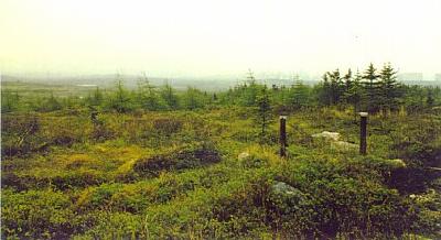
Figure 3. Proposed Site at Come by Chance. Looking South.
Fox Head
Fox Head was not identified in the original site selection process as a potential location for the transshipment terminal. Therefore, at the time of the field study no detailed site plan identifying where infrastructure facilities would be situated was unavailable. The boundaries of the study area were determined solely from a sketch provided by the proponent which showed only the projected maximum limits of impact. As a result, only that area was surveyed.
The terrain in the vicinity of Fox Head (Figure 4) is similar to that of the Come By Chance site. Essentially, it is a mixture of barren and bogland with some stunted forest, and a steep-sided shoreline that in places is near vertical. Despite a thorough investigation of the zone of impact, no historic resources of any description were identified. The lack of evidence of human occupation is clearly due to the overall nature of the terrain which is not in any way suited for human occupation. While the area may have been used for cutting firewood and for trapping small fur-bearing animals, these activities would have been of short duration and left little, if anything, in the way of archaeological signatures.
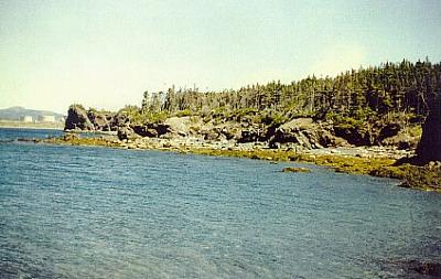
Figure 4. Shoreline in Vicinity of Foxhead. Looking North.
Whiffen Head
The investigation of Whiffen Head included the site of the proposed tank farm and support facilities, and the pipeline corridor from the fuel storage tanks to the shoreline. The terrain and vegetation where impact could occur are in almost every respect similar to that at Come By Chance and Fox Head. For the most part, it is hummocky and boggy, and there are several outcrops of exposed bedrock. The shoreline adjacent to the proposed tank farm is steep with only a short, narrow strip of beach that is exposed to virtually all but easterly winds. Because of these environmental conditions, it appears highly unlikely that the majority of the proposed site would have seen any prolonged human activity.
There was, however, one parcel of land of approximately 0.5 acres on the north side of Whiffen Head that did not conform with the typical environmental setting of the region. The area, referred to as Brinston’s Cove, is an elevated grassy clearing situated at the edge of a steep embankment, approximately 15 m above sea level. The only practical access is by boat, and in order to get from the beach to the top of the hill, one must either climb the almost vertical slope or trek through the dense growth of trees further north along the shoreline and approach the meadow from the northeast (Figure 5).
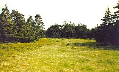
Figure 5. Brinston’s Cove, Whiffen Head. Looking North.
During the course of the initial field study, the entire terrace was subjected to a thorough walk-over in an attempt to identify any cultural features, and test-pitted for subsurface artifactual remains. The walk-over included not only the meadow but also the wooded perimeter, as well as the beach and sloping terrain behind it.
The investigation revealed that the central portion of the meadow had indeed been used for growing vegetables, and in the treed landscape at the perimeter, a number of wooden posts and wire fencing were located. Other than the collapsed remains of a small single-room cabin in the far southeast corner of the site, no indications of older buildings such as a dwelling, a barn and/or a storage shed were detected, either in the clearing or in among the trees. Based on these findings, it was tentatively concluded that the site had not been used for habitation, but more likely for small-scale food and hay production, and perhaps for grazing farm animals. Because segments of a fence were still standing, it was clear that the area was in use and privately owned until recently. Moreover, remains of a circular stone hearth and a scatter of modern garbage at one end of the meadow indicated that camping was likely a periodic activity.
Eighteen test pits positioned randomly throughout the meadow (particularly in the vicinity of the small vegetable garden where one might expect to locate cultural materials), and seven at the edge of the embankment above the shoreline where erosion was occurring failed to turn up any artifacts whatsoever. All test locations were culturally sterile. The visual inspection of the beach and the sloping terrain leading up to the clearing also revealed no significant evidence of human occupation. Furthermore, an examination from a high vantage point of the seabed immediately adjacent to the beach revealed no obvious configurations of stone such as might be expected if a wharf had been constructed in the cove.
In summary, then, the findings of the background research and the initial field assessment at Whiffen Head suggested that even though the clearing above Brinston’s Cove had been used for small-scale agriculture until very recently (that is, within the last fifty years or so), no settlement had occurred. While there had been periodic stopovers of short duration while fishing, farming and possibly hunting in the second half of this century, the lack of older physical remains suggested that no prolonged occupation took place either in the recent or more distant past. These results were not entirely surprising given the exposed nature of that particular stretch of shoreline, the relatively narrow beach and the lack of easy access to that terrace.
Even though the above data appeared conclusive with regards to land use and occupancy of Whiffen Head, information provided by the owner’s son pointed in a somewhat different direction. While he agreed that the meadow was used more or less as outlined above, he also made reference to it having been occupied by his great, great, great-grandfather on a permanent basis, which, if accurate, could suggest a time period of c. 1800. He did state, however, that despite having spent substantial time at the site over the years, he had never come across any structural or artifactual remains while farming or otherwise to confirm his statement, nor did he know of anyone else who had. Given that the meadow in question is not that large, and the plot of land farmed relatively small, if his statement regarding a relative having resided there is correct, the total lack of physical evidence detected during the initial archaeological assessment is somewhat surprising. In any event, because of the contradictory information, and the possibility that historic resources could conceivably have been missed during the initial field study, further testing was scheduled.
In April of 1997, approximately thirty additional test pits were excavated in the grassy meadow and around the periphery of the wooded area, and a second visual inspection carried out. Any location that could conceivably have been used for occupation was sampled. The outcome of the second field investigation was identical to the first in that no archaeological materials of any description were recorded. Again, all test areas were totally sterile. Not as much as a single fragment of lithic material, ceramic, glass, clay smoking pipe, or iron nail was unearthed.
Admiral’s Beach
The area surveyed at Admiral’s Beach, St. Mary’s Bay included the proposed tank farm and future tank farm, the proposed causeway and the coastal strip in front of the site on the west side of Route 94. In order to facilitate investigation, an existing transmission cut through the woods and bisecting the site in roughly the central location was walked from southwest to northeast. By following that transect it was possible to obtain a reasonably good overview of the entire area and investigate in more detail any locations in the interior that appeared to hold potential for historic resources.
The Admiral’s Beach site is situated in a raised wooded area that contains a number of bogs and small brooks. At the southwestern end of the study area there is a dump that is currently in use by the adjacent communities. The shoreline portion of the site where the proposed causeway would be situated (as is the entire stretch of shoreline in this area) is steep sided with only a narrow beach (Figure 6). The topographic conditions of the coastal strip and the location selected for the tank farm and infrastructure facilities are such that it is unlikely there would be any prolonged human usage. At no location within the study area were any remains, or potential for remains, of historic resources significance identified.
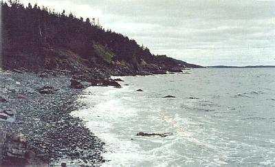
Figure 6. Shoreline at Admiral’s Beach. Looking Southeast.
Conclusions
In June of 1996, a Stage 1 Historic Resources Impact Assessment of four locations considered for construction of the Newfoundland Transshipment Terminal was conducted. Included were: Come By Chance, Fox Head and Whiffen Head in Placentia Bay, and Admiral’s Beach in St. Mary’s Bay. Information acquired through background research indicated that even though the potential for the presence of archaeological materials at all four sites was probably low owing to the nature of the environmental setting and, at Come By Chance, previous ground disturbance, a thorough field investigation of each area would nonetheless be prudent prior to a final site selection and commencement of construction activities (BAE NEWPLAN GROUP 1996). Despite a comprehensive field examination, no materials of archaeological significance were identified. The historic resources potential for all areas was found to be low. As a result, no mitigative measures or additional study is recommended.
With regards to the study area at Whiffen Head, even though one informant stated that the small clearing above Brinston’s Cove had been occupied sometime during the early nineteenth century by a relative, no documentary or physical evidence to support this claim was found. Even though the area had most definitely been used for small-scale agriculture during this century, and debris from a dilapidated wooden cabin dating to the 1950s or 1960s is clearly evident in the southeast corner of the meadow, no artifactual or structural materials consistent with an earlier occupation were identified during two stages of field testing. In fact, information obtained from the most recent land owner and from the Register of Grants at the Department of Government Services and Lands, suggests that such a statement may not be accurate. The total lack of archaeological material provides additional support for this conclusion.
References
BAE NEWPLAN GROUP
1996 – Site Selection Study: Newfoundland Transshipment Terminal. Copy on File with Jacques Whitford Environment, 607 Torbay Road, St. John’s, Newfoundland.
Gilbert, William and Ken Reynolds
1990 – “A Report of an Archaeological Survey: The Come By Chance River and Dildo Pond.” Report submitted to the Historic Resources Division. Copy on file with the Culture and Heritage Division, Government of Newfoundland and Labrador, St. John’s.
Linnamae, Urve
1971 – “Preliminary Report of an Archaeological Survey of Placentia Bay, Newfoundland.” Report on File at the Centre for Newfoundland Studies, Queen Elizabeth II Library, Memorial University of Newfoundland, St. John’s.
Government of Newfoundland and Labrador
n.d. – Register of Grants, Volume 196. Department of Environment and Lands, Government of Newfoundland and Labrador. On file at the Howley Building, St. John’s.
Tuck, James
1996 – “Archaeological Resources in the Come By Chance and St. Mary’s Bay Areas.” A preliminary assessment prepared for the BAE NEWPLAN GROUP. Copy on File with Jacques Whitford Environment, 607 Torbay Road, St. John’s, Newfoundland.