
Archaeology in Newfoundland and Labrador 1997
Edited by K. Nelmes
Report of an Archaeological Investigation: Harbour Grace Boat Basin, Harbour Grace, Newfoundland
Roy Skanes
Background
Historical Overview
Harbour Grace is situated roughly mid-way along the western shore of Conception Bay, approximately 45 km northwest of St. John’s. In the mid-sixteenth century, the area was used extensively for seasonal fishing activities by ship’s crews from the Channel Islands. In the early seventeenth century, even though settlement had not yet taken place, the harbour was well known to English mariners, and by 1615, a prosperous fishing business was carried out there under the direction of John Mason, the governor of Cupids. By 1675, when Commodore Sir John Berry conducted a census, the year round English population was thirty-six; the summer population, however, fluctuated from 330 to 550 individuals (Encyclopedia of Newfoundland and Labrador 1967:808-809).
At the beginning of the eighteenth century the community was well established and the economy was beginning to diversify with shipbuilding becoming an important activity. By mid-century, large mercantile establishments were building up businesses in Harbour Grace, including the Boston firm run by the Webber family. The Conception Bay fishery of that time was considered to be equal to one quarter of the entire Newfoundland fishery (Prowse 1972:296-297).
Early in the nineteenth century sealing an important industry, providing additional work in the boatbuilding trades during the winter months, as well as hunting, curing skins and manufacturing oil. The prosperity of the town suffered a major setback in 1832 when a fire completely destroyed the business community. By 1857 Harbour Grace boasted a population of 5,095, however, by 1935 the number had declined to 2,215. The recent downturn in the fishery has resulted in further erosion of the community’s population and business establishments (Encyclopedia of Newfoundland and Labrador 1967:809-813).
Boat Basin Project
In the fall of 1997, the Harbour Authority of Harbour Grace commenced construction of a boat basin on the south side of the community in an area referred to as either Long Beach, or by its nineteenth century designation, Kings Beach (Figure 1).
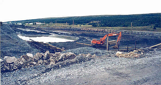
Figure 1. Harbour Grace Boat Basin, looking southeast.
During the second week of September 1997 it was reported to the Culture and Heritage Division, Department of Tourism, Culture and Recreation that three ship’s timbers had been unearthed during excavation of the pond. On 14 September 1997, the provincial government Resource Archaeologist, and myself travelled to the site to assess the situation and provide advice to site workers as to the proper course of action to follow in the event of further finds. Upon viewing the remains, it was clear that they were fabricated from a non-local wood species and that one relatively undamaged component was a floor-timber from the mid-section of a vessel in the order of 50-60 feet in length. Due to the limited sample, it was virtually impossible at that time to determine the age and place of origin. The problem of dating and provenience was further complicated by the fact that other than the three disarticulated ship’s components, two of which had been severely damaged by the tractor, no additional physical remains, either structural or artifactual, were recovered. Information provided by site workers as to where the timbers were initially unearthed suggested a location more or less in the centre of the boat basin.
Research and Analysis
Field Research
In an effort to establish if additional ship’s components were present in the construction zone, archaeological testing was carried out in two phases. Initially, an approximately 1 m wide trench was excavated with a backhoe virtually the full length of the basin in roughly the central location. The work was supervised by myself; however, the test area was selected by the project foreman, who felt that particular transect, because it was in the vicinity of where the original timbers apparently discovered, should intersect the articulated structure. The excavation extended an average of 2 m below grade, for a total depth of approximately 4 m below sea level. As well, the area inside the boat basin and a number of vertical soil profiles at the perimeter were examined for cultural remains, and site workers were interviewed further to determine what types of artifacts, if any, had been unearthed during construction, and where.
Following excavation of the initial longitudinal trench, a discussion took place between the foreman and myself as to the appropriate procedures to follow for the duration of the construction project, given that the depth of the basin still had to be increased substantially and there existed some potential, even though limited, for further findings. The strategy implemented was as follows: whenever dredging was carried out, a site monitor would be positioned on the tractor with the sole responsibility of watching for cultural materials. In the event materials were unearthed, a work stoppage in that area would be effective immediately, the location clearly marked, and a call placed to the Culture and Heritage Division for advice.
A second and final stage of archaeological field testing was carried out at arbour Grace on November 26 and 27. This work, also conducted with a backhoe, concentrated on excavating a series of exploratory pits at the eastern end of the boat basin where it was thought articulated ship’s components were situated. In total, an area encompassing approximately 50 m2 was sampled to a depth of 4 to 4.5 m below sea level.
Archival Research
Limited map research was conducted at the Centre for Newfoundland Studies and the Map Room (Memorial University of Newfoundland) in an effort to obtain information regarding the historic configuration of the pond and whether or not it had been utilized in the past for fishing and/or shipping related activities. The rationale behind the research was that if the pond had been a centre of activity, for whatever reason, it would probably be indicated on the cartographic record of the area. An attempt was also made to view similar documentation at the Provincial Archives of Newfoundland and Labrador. Unfortunately, however, due to the time involved in accessing the map collection at that institution, the effort was abandoned.
Laboratory Analysis
The ship’s timbers from Harbour Grace were transported to St. John’s for cleaning, preliminary study, and storage at the Culture and Heritage Division’s Conservation Laboratory. Wood samples were submitted for species identification and radiocarbon dating. Dr. Peter Scott of Memorial University’s Department of Biology conducted the wood identification, and the Accelerator Mass Spectrometry Facility at the University of Toronto carried out the C14 analysis.
Results
Both the initial exploratory trench and subsequent field testing revealed below a sandy substratum at approximately 3 m below sea level, a concentration of organic materials comprised of extremely well preserved peat, tree branches and trunks. While the density of the layer varied somewhat depending on the location within the basin, generally it measured in the order of 0.5 m thick. Despite the significant research effort carried out on two occasions, no cultural remains or evidence of cultural activity (such as cut or modified wood) was identified, either from the trench, on the floor of the boat basin, or from any of the vertical soil profiles created on the perimeter as a result of construction activities. Virtually all areas investigated proved to be culturally sterile. Moreover, each site worker interviewed stated that to their knowledge very few artifacts, such as ceramics, glass and/or smoking pipe fragments, had been unearthed during excavation. The few items that did turn up were spotted during the initial stages of the project when the pond bottom was at a much higher elevation. A number of individuals considered the lack of findings somewhat peculiar, and not at all what they expected, given their previous experience on other construction projects in and around Harbour Grace where generally significant quantities of materials were unearthed.
A review of maps of Harbour Grace from the eighteenth, nineteenth and mid-twentieth centuries showed no evidence whatsoever that the small saltwater pond or the adjacent shoreline had been used for fishing and/or shipping related activities. In fact, a hydrographic chart of the area drafted in 1886 shows certain sectors of the harbour as having as little as 0.75 fathoms or 4.5 feet of water – that is, approximately 1.3 m. The depth in the pond, however, is not listed at all, which might suggest it was less than the minimum recorded. Moreover, the area inside the pond is shaded identically to certain sectors of beach and shoals, indicating perhaps that it too was virtually dry at low tide and therefore a hazard to shipping.
Laboratory research established that the ship’s timbers recovered from Harbour Grace were fabricated from European Ash. Unfortunately, however, it was not possible to provide a more precise provenience. The radiocarbon analysis, also somewhat inconclusive, did suggest that the sample submitted dates to after 1700.
Conclusions
The following is a presentation in point form of conclusions regarding the finds from Harbour Grace harbour:
The Archaeological Remains
- Because the timbers retrieved from the saltwater pond are fashioned from European Ash, it is unlikely they are from a locally constructed vessel, unless of course the wood was imported, which seems highly improbable.
- The dimensions of the undamaged floor-timber suggest a vessel of approximately 50-60 feet in length with a maximum draft in the order of 3 m.
- Because the results of the C14 analysis were somewhat inconclusive, and no period-specific cultural remains were associated with the wreckage, it is not possible to provide a definitive date. However, based on the general shipbuilding technology deduced from the timbers, it would appear that the vessel pre-dates this century.
- Evidence suggests that the floor-timber would have been attached to the keel with wooden treenails, and exterior planking to framing with both iron and wooden fastenings. Abrasion of the floor-timber, and the fact that the treenails exhibited no evidence of recent fracturing, suggest: a) this particular ship’s component had been moved around on the harbour bottom by wave action for an unknown period of time; and b) the floor timber was not articulated to a keel or any other structure at the time of discovery.
The Saltwater Pond
- The depth of the saltwater pond at the beginning of the construction project was in the order of 0.75 m. An informant who had resided adjacent to the pond and fished in it during his youth, stated that in the 1920s the depth was virtually the same as it was when excavation commenced. Therefore, it follows that the water depth has been consistent for at least the last one hundred years. Supplementary evidence obtained from historic and contemporary maps not only confirms the informant’s statement, but also suggests that similar conditions have prevailed since the early eighteenth century.
- Site workers noted few artifacts during excavation. Those unearthed, including the ship’s timbers, were encountered during the initial stages of construction.
- No artifacts were recovered during any phase of archaeological research. All areas investigated were determined to be culturally sterile.
Overall Conclusions
Based on the information provided above, it is almost certain that the water depth in the pond has been, at least since the sixteenth century when Europeans first occupied the area, more or less the same depth as it was when the construction project began earlier this year. If, prior to this century, the pond had been sufficiently deep to secure vessels of 50 feet or so, there would have to have been at least 3 to 4 m of water at low tide. If that was the case, almost certainly the pond would have been used extensively for fishing and transport vessels. As well, given the nature of the fisheries economy, at some point over the past five hundred years, shoreline structures such as stages, slipways and wharves would have been constructed on the perimeter, and if so, evidence of such activities would be present in the sediments. As discussed, this was not the case.
The only reasonable conclusion to be drawn from the above is that due to the shallowness of the pond, it and the adjacent shoreline experienced very little, if any, use over time. The few items deposited in the sediments were located relatively high up and therefore displaced by the tractor early in the project. With regards to the ship’s timbers, it is highly probable that they washed into the pond from the harbour, either over the beach-cobble berm during a storm, or through the entrance at high tide. The abraded condition of the floor-timber supports this hypothesis, as does the total lack of other cultural remains.
References
1984 – Encyclopedia of Newfoundland and Labrador, Vol. II, pp. 807-814. Newfoundland Book Publishers (1967) Limited.
Prowse, D. W.
1972 – A History of Newfoundland from the English, Colonial and Foreign Records. Facsimile 1895 edition (MacMillan and Co., London and New York), Mika Studio, Belleville.