
Archaeology in Newfoundland and Labrador 1997
Edited by K. Nelmes
Stage 1 Historic Resources Overview Assessment: Southwest River, Newfoundland
Roy Skanes
Background Research
The following essential tasks were completed prior to commencement of the field survey:
- a literature review to acquire insight into the environmental setting and resource profile for the project area and vicinity
- a search of the Newfoundland and Labrador Archaeological Site Record Inventory to determine if archaeological remains are registered for the project area or general vicinity
- a review of published and unpublished archaeological reports, other relevant literature, maps and aerial photographs to determine the human history of the region and to identify any areas of potential within the project area
- informant interviews with individuals familiar with the region to obtain an understanding of past land-use patterns and to determine if any historic resources had been previously located within or adjacent to the project area
Field Survey
The field survey, conducted in June of 1997, consisted of a thorough walk-over of both sides of the river, starting at a point approximately 200 m downstream of a proposed powerhouse and extending up to and including the terrain adjacent to the upper falls. Frequently, and in areas where the topography permitted, both wooded and open areas back from the riverbank were investigated. Because the majority of inundation will occur along the east side of Southwest River, a single transect following the high ground between the two sets of falls on that side was also conducted. As well, the route of the main access road, the transmission line, the interconnecting line and the general vicinity of the secondary access roads adjacent to the river were walked as closely as possible and examined for any indications of historic resources potential (Figure 1). Because the corridors for the various roads and power lines were not completely cleared of trees and brush, or precisely marked in any way, it is likely that the field investigation did not accurately cover the terrain that will be impacted as a result of the construction of these facilities. Nonetheless, it was sufficient to at least permit a general statement regarding the level of potential for historic resources in these areas.
Locations within the project area that held even slight potential for the presence of historic resources were subjected to judgmental test-pitting. In all test locations, approximately 30 cm2 squares were excavated to an underlying sterile subsoil. All test locations were indicated on a 1:50,000 scale topographic map and a photographic record of all relevant locations in the project area was obtained.
Figure 1. Southwest River Hydroelectric Project: Location Plan.
Survey Results
Background Research:
Environmental Setting
Southwest River is a relatively narrow and slow-moving waterway that flows out of Island Pond in a northerly direction towards Clode Sound. The river downstream of the lower falls is comprised of a 20 m wide by 30 m long pool. The riverbank at that location consists of steep-sided cliffs on either side leading directly into the water. The area directly above the lower falls is essentially a bedrock gorge with near vertical cliffs on the west side, and a sloped bedrock face on the east side.
The river upstream of the proposed dam site widens somewhat with a depth range of between 0.25 to 0.5 m. The substrate and riverbank in this sector is essentially bedrock rising as steep cliffs. There are, however, along this section of the river, between the upper and lower falls, a number of level, grassy areas directly adjacent to the water’s edge (Figure 3). These features are generally situated at bends or curves in the river and appear to have been formed as a result of silting. The combined physical characteristics of these locations (level, well-drained and close to the water) suggested that they could have been used for small camp sites of short duration. As a result, testing for the presence of historic resources was conducted.
Human History
A review of the Archaeological Site Record Inventory and published and unpublished archaeological reports at the Culture and Heritage Division indicated that no sites or materials of heritage significance are registered for the project area or immediate vicinity. There are, however, along the shoreline of Clode Sound, to the north and east of Port Blandford where Southwest River flows into Bonavista Bay, a number of sites known to have been occupied by Aboriginal and/or European populations.
The closest site to the project area is situated in Northwest Arm, approximately 1 km south of the mouth of Northwest River (approximately 12 km from the mouth of Southwest River). Even though the site (DcAn-1) is registered with the Culture and Heritage Division as “historic Micmac,” because no detailed description of the remains exists, the ascribed cultural affiliation and suggested time period may be questionable. A second archaeological site (DcAm-2) is situated in Platter Cove to the north of Port Blandford. The remains at this location, consisting of an assemblage of hearth stones and relatively modern cultural debris, suggested that the site was European and twentieth century (Tuck 1980). A third site in Clode Sound (DcAm-1) was identified at Charlottetown Point. The assemblage of artifacts from this location consisted of approximately 200 white quartz flakes and spalls – unquestionably the remains of stone tool fabrication by Aboriginal people. Even though not determined decisively, it was speculated that the artifacts were “Indian,” however, no specific time period was provided (Tuck 1980).
The overall results of the archaeological survey work conducted to date along coastal areas of southwestern Bonavista Bay indicate that the general area has experienced a long-standing human presence spanning a period of approximately five millennia. The occupation began with Maritime Archaic Indians, followed by Paleo-Eskimos, Recent Indians and Europeans (Tuck 1980). Unfortunately, however, no conclusive evidence to confirm a Micmac presence (as suggested by the site referred to as DcAn-l) was identified. There is, however, at least one reference from the nineteenth century to suggest that such an occupation of Clode Sound did in fact taken place.
In 1822 William E. Cormack and Joseph Sylvester, a Micmac guide, walked across the island of Newfoundland in an attempt to make contact with any remaining Beothuk Indians. They departed from Random Bar, Bonavista Bay on 5 September and proceeded in a roughly westerly direction towards the interior. On 10 September, after having travelled approximately 30 miles inland, Cormack reports in his journal that:
Early in the day, the ground descending, we came unexpectedly to a rivulet about seventy yards wide, running rapidly over a rocky bed to the north-east, which we forded. The bed and shelving banks are formed of granite, mica and transition clay slate rocks. Some of the latter inclined to serpentine, greenstone, red sandstone of the coal formation, sand, and beds of fine yellow clay. The water was in some parts brought into a very narrow compass by the rocks projecting from the sides. Large birch and spruce trees overhung the banks, and rendered the scenery pretty. It abounded with fine trout, some of which we caught. The sand was everywhere marked with tracks of deer. The roaring of a cataract of some magnitude was heard in the north-east. From the position and course of this stream, we inferred that it was a branch of the river which runs into Clode Sound, in Bonavista Bay: and my Indian supposed, from his recollections of the reports of the Indians concerning Clode Sound River, that canoes could be brought up from the sea to near where we were. (Cormack’s journal, reproduced in Howley 1974:138)
Based on the location and physical description of the body of water described by Cormack, it seems likely that he is referring to a location on Southwest River somewhere upstream (that is southwest) of either the lower or upper falls. Given the route that he and his guide followed after leaving the coast, as illustrated on a nineteenth century map of Newfoundland (Marshall 1997:184), and his recollection of the distance covered in the five day period, there is really no other river that it could be. Northwest River would appear to be too far north, as would Terra Nova River, which in fact does not flow into Clode Sound. In any event, the reference is of significance in that if Sylvester’s statement regarding “Indians” (presumably meaning Micmac and not Beothuk) using the waterway up to that distance is accurate, it could suggest that the immediate project area, or at least the section of Southwest River from the coast up to the lower falls, was utilized in the early nineteenth century, possibly as a travel route to the interior.
The nearest community to the project area is Port Blandford which is located approximately 10 km to the north, at the mouth of Southwest River. The area was first settled in the 1870s when people moved up to the bay from older settlements to partake in the fishery, lumbering and boatbuilding industries. The construction of the railway through the area in the 1890s resulted in an increased population, as there became a demand for a substantial quantity of railway ties. In about 1901, Daniel Pelley established a sawmill on Southwest River, relying on the area upstream for logs and the waterway to transport the product to the coast. Eventually, the Pelley firm became the largest employer of local labour – operating in addition to the sawmill, a shipyard, contracting the cutting of pulpwood and pitprops, and running the largest general mercantile firm in the area (Encyclopedia of Newfoundland and Labrador 1993: Vol. IV, p. 388).
Informant interviews conducted with a number of residents of Port Blandford as part of the Stage 1 Assessment not only confirmed that throughout the majority of this century the inland area to both the north and south of Clode Sound was indeed used extensively for various wood-harvesting industries, but also shed light on recent land-use patterns and travel routes used to access the resources of the interior. One Port Blandford man approximately eighty years of age indicated that he started working in the “lumber-woods” as a young man and continued to do so for approximately fifty years. He had been involved in cutting timber inland of Port Blandford and as far as Tug Pond situated southwest of Clarenville. Throughout his career, Southwest River was used to transport logs and box wood (precut lengths used for fabricating wooden shipping crates) from the interior to the coast. According to him there were no cabins situated within the project area, but there were a number of logging camps established approximately 3-4 miles, or roughly a one hour walk, upstream from the upper falls. These camps were used exclusively during the winter, and the wood the crews cut was floated out to the coast in spring after breakup. In order to get to the camps from Port Blandford, this man normally walked, or travelled by dog team, along the high ground above Southwest River, moving back and forth from the east side to the west side following the open ground. Upon arrival at the upper falls, he would then travel on the frozen river until he reached camp. Above the upper falls, the river is wider and level, unlike below.
Other activities undertaken by this man during the winter in the vicinity of the project area included trapping small game, hunting caribou and moose, and trout-fishing. At other times of the year he fished for salmon downstream below the lower falls. In his time spent at Port Blandford, he does not remember boats or canoes going up Southwest River, and in fact, doubted if they could, due to the water depth, which fluctuates frequently depending on the time of year, but is usually low. One final point made by him and another informant also from Port Blandford, was that they had never located any artifacts to indicate a pre-twentieth century use of the area by Europeans or Aboriginal people, nor did they know of anybody else who had done so.
In summary, then, the review of material conducted as part of the background research indicated the following points to the principal researcher of this study:
- Southwest River, both below the lower falls and up to the upper falls, is rocky and shallow (being an average of less than 0.5 m deep), and as such was probably not navigable by small boats or canoes. Even though a suggestion to the contrary exists from 1822, it is possible that the statement, which was based on “recollections of reports”, is inaccurate and that Cormack was referring to another waterway, perhaps Northwest River
- aerial and surface photographs, and topographic maps, indicated the banks of the river between the upper and lower falls are generally steep-sided with very few locations suitable for temporary camps
- archaeological and documentary evidence indicated that the coast of southwestern Bonavista Bay to the north of the project area had been occupied by human populations intermittently for the past 5000 years
- the resource profile for this sector of the island (which included large and small mammals, waterfowl, freshwater fish and timber) was sufficiently rich that cultural groups known to have occupied adjacent coastal areas could (and did) utilize interior resources as well, at least on a seasonal basis
- travel to the interior in summer along the banks of Southwest River would have been extremely problematic due to the topography and forest growth, and in winter, a more practical route, at least as far as the upper falls, would probably have been along the high and open ground above the rivertravel to the interior in summer along the banks of Southwest River would have been extremely problematic due to the topography and forest growth, and in winter, a more practical route, at least as far as the upper falls, would probably have been along the high and open ground above the river

Figure 2. Site of Proposed Powerhouse, Looking Upstream.
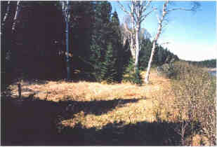
Figure 3. Level Grassy Area Adjacent to Riverbank.
Conclusion
Despite a visual inspection of the proposed areas of ground disturbance and inundation, and sub-surface testing at various locations along the river, no historic resources of any description were identified. Even though one historical reference from the early nineteenth century suggests that Micmac from the Port Blandford area (at that time probably known as Clode Sound) may have come up Southwest River in canoes as far as the lower falls, this seems unlikely given the water depth, which is in most places less than 0.5 m deep. If, however, the reference is accurate, it could indicate that Southwest River was used as part of a travel route from the coast to the interior (as was the case in this century with forestry workers from Port Blandford), or that people ventured as far as the falls in canoes to fish and/or to hunt and trap. Given that salmon migrate upstream in the spring and early summer when water levels would probably be at their highest, boat travel at that time of year may have been conceivable. If so, temporary camp sites may have been established somewhere in the vicinity of the falls. As stated, the area investigated at that location, both at water level and above the river on the elevated ground, revealed no obvious signs of human occupation. It must be acknowledged, however, that in that particular section of the project area access was difficult because access corridors were not entirely cleared of trees and brush, therefore the field survey was limited to the accessible areas and what could be seen.
With regards to the areas above the lower falls, it can be concluded from informant interviews that during this century it was used for hunting, trapping, trout fishing, as a travel route to the interior, and intermittently, for lumbering operations, all of which activities would have left little, if any, archaeological remains. According to our key informant, no accommodations were constructed along Southwest River between the two falls. Prior to this century, if Aboriginal people had established small camps adjacent to the water during brief hunting and/or fishing trips (possibly on a seasonal basis), they would almost certainly have chosen one of the few level and well-drained locations mentioned above, and as stated, all of these areas were test-pitted with negative results. Moreover, if the modern route to the interior had also been followed by Aboriginal people earlier, finding evidence of such land usage would be extremely difficult and time consuming, given the size of the area and the fact that any camps would almost certainly have been small and temporary, with few inorganic materials deposited.
In conclusion, it can be stated that due to the generally unsuitable nature of the topography, the vast majority of the project area has low potential for historic resources. While a number of areas on the river held some promise for archaeological materials, test-pitting at these locations proved negative. Because certain undefined locations within the headpond could have been used for small camp sites prior to this century, the historic resources potential for that sector of the site could be considered moderate to low.
References
1991 – Encyclopedia of Newfoundland and Labrador, Vol. III. Robinson-Blackmore Printing and Publishing Limited, St. John’s.
1993 – Encyclopedia of Newfoundland and Labrador, Vol IV. Robinson-Blackmore Printing and Publishing Limited, St. John’s.
Frontier Hydro Development Ltd.
1992 – “Southwest River (Run-of-River) Small Hydro Development.” Registration Form. Copy on file at Jacques Whitford Environment, 607 Torbay Road, St. John’s.
Marshall, Ingeborg.
1997 – A History and Ethnography of the Beothuk. McGill-Queen’s University Press, Montreal and Kingston.
Government of Newfoundland and Labrador.
1992 – “Historic Resources Impact Assessment guidelines.” Culture and Heritage Division, Department of Tourism, Recreation and Culture, St John’s.
Howley, James.
1974 – The Beothucks or Red Indians: The Aboriginal Inhabitants of Newfoundland. Coles Publishing Company Limited, Toronto, Canada. Facsimile edition. Original published in 1915 by Cambridge University Press.
South, G. Robin.
1983 – Biogeography and Ecology of the Island of Newfoundland. Dr. W. Junk Publishers, The Hague, Boston.
Tuck, James.
1980 – “An Archaeological Survey of Terra Nova National Park.” Report prepared for Parks Canada, Halifax, Nova Scotia. Copy on file at the Culture and Heritage Division, Department of Tourism, Recreation and Culture, Government of Newfoundland and Labrador, St. John’s.