
Archaeology in Newfoundland and Labrador 1997
Edited by K. Nelmes
Stage 1 Historic Resources Assessment of Goose Arm Proposed Cottage Development
Marianne P. Stopp
Introduction
This report presents the results of a Stage 1 Historic Resources Impact Assessment of cottage development areas in Goose Arm, western Newfoundland. The cottage developments are situated along the head of Goose Arm, both on the coast and somewhat inland. The Goose Arm development areas are presently accessible via a rough logging road running west from Deer Lake. Alternatively, one could reach Goose Arm by boat from the Bay of Islands (Figure 1).
The following paragraphs describe the study area, the field methodology, the results of the Stage 1 field assessment, with an evaluation and discussion of the results.
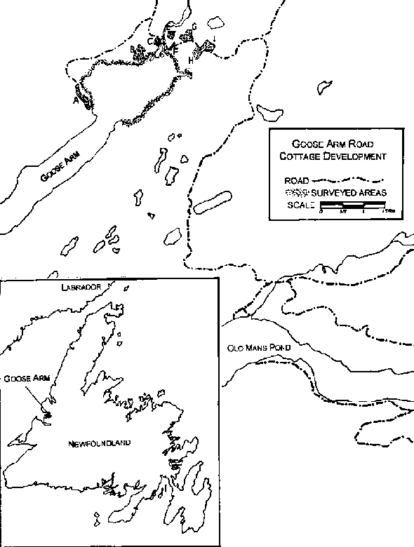
Figure 1. Goose Arm Surveyed Areas.
Description of Study Area
As an arm of the Bay of Islands, Goose Arm is within the tidal zone and consequently lacks a beach margin at high tide. The shore rises steeply from the water for roughly 1.5 metres. Goose Arm Brook North and the wider Goose Arm Brook converge approximately two kilometres inland, and flow into Goose Arm from the northeast. These two waterways create a considerable area of silt deposition at the head of Goose Arm.
As the presence of the logging roads suggests, the hinterland of Goose Arm is dense boreal forest. The shoreline of Goose Arm is wooded with somewhat more bog immediately inland along the north shore. The general landscape of the proposed cottage areas is one of disturbance due to quarrying, gravel dumping, and bridge and access road construction. It is unclear whether the shoreline at the head of Goose Arm was as silted prior to logging. Topographic maps from the 1970s show boom piers across the northwest half of Goose Arm – there is no sign of these today. The water systems flowing into Goose Arm are all controlled by small dams while the hinterland has undergone extensive logging operations. All of these factors, mechanical equipment disturbance, river dams, and interior logging, have contributed towards a landscape which undoubtedly reflects little of its prehistoric aspect.
Methodology
Access to the cottage development areas (labelled A, B, C, E, F, G, H, I by the Department of Environment and Lands) in Goose Arm was via the lumber road. Each cottage development area was visually surveyed and subsurface surveyed where feasible. The entire shoreline of the head of Goose Arm was checked, from William Wheeler Point along the south shore to the unnamed point just southwards of Northwest Cove on the north shore (and opposite William Wheeler Point).
Results And Evaluation
The results of the Stage 1 testing are summarized in Table 1. No evidence of cultural material was found. As the information in Table 1 indicates, the majority of development areas (A, C, E, F, G, H, I) have been severely impacted by road development, grading, fill dumping, and cabin development.
Previous archaeological work in the vicinity includes two surveys at Old Man’s Pond, approximately seven kilometres southeast of the head of Goose Arm (Renouf 1991, Schwarz 1992). Neither survey recovered any evidence of cultural resources. Archaeological survey has, however, located cultural material at the mouth of Middle Arm, Bay of Islands, of which Goose Arm is an extension. The Parke’s Beach site contains extensive Groswater and Middle Dorset components (Reader 1996, 1997). The Parke’s Beach site clearly indicates that the Middle Arm-Goose Arm waterway was inhabited by prehistoric peoples.
Conclusions
The use of the coastal area by prehistoric peoples in the Middle Arm-Goose Arm waterway is evidenced by the Parke’s Beach site. Given the disturbed nature of the study area, it is difficult to interpret whether prehistoric land use was restricted to the outer coast, or whether the area around the mouth of the Goose Arm Brook was also once occupied.
In closing, surface and sub-surface testing of the head of Goose Arm yielded no evidence of cultural resources. All but one of the cottage development areas were extensively disturbed due to mechanical earth moving during the original construction of the logging road. The logging road has in turn made the area amenable for cabin development. Although cabin development itself does not as a rule result in extensive areal disturbance, ancillary developments such as access routes, particularly when built for logging trucks, do cause considerable ground disturbance. It is entirely possible that logging access routes elsewhere in the province will in time provide the impetus for further developments such as cabins. With this in mind, it is recommended that the development of logging access roads be carefully considered as potential areas for Stage 1 assessments.
Table 1. Description of Cottage Development Areas A, B, C, E, F, G, H, I, and of Goose Arm Shoreline
| Area | Description |
|---|---|
| A | steeply sloping shoreline, extensively disturbed by road excavation, visual survey |
| B | accessible along brook from shoreline; test-pitted along shore of brook which is west boundary of Area B; interior of Area B quite boggy and not test-pitted; wooded slope towards Goose Arm (south 1/2 of Area B) test-pitted |
| C | west 1/2 disturbed by grading and dumping road fill also serves as trailer site; east 1/2 disturbed by road construction; surface surveyed |
| E | south 1/2 disturbed due to road and bridge construction; surveyed along river shore and steep slope from river to Area E which is extensively disturbed by a large landslide |
| F | disturbed due to gravel quarrying and road construction; visually surveyed |
| G | cabins on this property; visually surveyed access road margins, gardens, and all areas excavated during either road or cabin construction |
| H | soil buildup due to road fill dumping; visual survey of all excavation cuts; terrain adjacent to brook steep and not test-pitted |
| I | west part is gravel pit with camper trailers present; east of this is a contemporary cabin; remainder of area is steep and not tested; road construction has impacted along the south side of property; all open areas visually surveyed |
| SHORE-LINE | entire shoreline visually surveyed during low tide and test-pitted at all existing or relic river/stream cuts; survey included following river/stream banks of the tributaries of Goose Arm Brook and streams flowing into head of Goose Arm |
References
Reader, D.
1996 – “Archaeological Investigation Along the North Shore of the Bay of Islands, Newfoundland, 1995.” On file at Culture and Heritage Division, Department of Tourism, Culture, and Recreation, Government of Newfoundland and Labrador.
1997 – “Archaeological Excavations at Parke’s Beach, Bay of Islands, 1996: Groswater, and Dorset Palaeoeskimo and Beothuk Components.” On file at Culture and Heritage Division, Department of Tourism, Culture, and Recreation, Government of Newfoundland and Labrador.
Renouf, M.A.P.
1992 – “Results of Phase 1 Historic Resources Impact Assessment, Old Man’s Pond, Western Newfoundland, 31 July and 4 August, 1991.” On file at Culture and Heritage Division, Department of Tourism, Culture, and Recreation, Government of Newfoundland and Labrador.
Schwarz, F.
1992 – “Report on the Results of a Stage 1 Historic Resources Impact Assessment of Old Man’s Pond, Western Newfoundland.” On file at Culture and Heritage Division, Department of Tourism, Culture, and Recreation, Government of Newfoundland and Labrador.