
Archaeology in Newfoundland and Labrador 1997
Edited by K. Nelmes
Stage 1 Historic Resources Assessment of Long Pond-Traverse Brook Cottage Development Area
Marianne P. Stopp
Management Summary
This report presents the results of a Stage 1 Historic Resources Impact Assessment in the Long Pond/Traverse Brook area of proposed cottage developments. Eight areas of proposed cottage developments were assessed (Figure 1). Despite intensive surface and sub-surface investigation of the eight areas, no evidence of cultural resource material was located.
Introduction
The cottage developments are situated on Long Pond, approximately four kilometres north of Road 320 and between Middle Brook and Hare Bay on the Island of Newfoundland. Each of the eight development areas is situated along the shores of Long Pond. Long Pond is presently only accessible by canoe and portage in summer, and by snowmobile in winter (Figure 1).
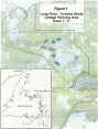
Figure 1. Long Pond – Traverse Brook Cottage Development Areas.
A crew of three archaeologists accessed and checked the Long Pond cottage development areas between June 25, 1997 and June 28, 1997.
The following describes the study area, the field methodology incorporated, the results of the Stage 1 field assessment, an evaluation and discussion of the results of this particular fieldwork, as well as recommendations.
Description of the Study Area
Each of the eight test areas proved to be extremely boggy with some intermittent boreal forest vegetation. With the exception of a narrow sand beach fronting Area 1, the shoreline of Long Pond is a narrow strip of gravel. Local informants indicated that the area had been de-forested (to the extent that this was possible, as the bogs are not recent) around the turn of the century. Today there are three cabins on the pond which are frequented in the winter time (see Table 1).
Methodology
Access to the cottage development areas on Long Pond was by canoe across Traverse Pond and Round Pond with an extremely difficult portage across bog into Long Pond. Each cottage development area was visually surveyed and sub-surface surveyed where feasible. Descriptions of local stratigraphy were maintained. Records were also maintained of any recent historic material but none collected see Table 1).
Results and Evaluation
The results of the Stage 1 testing are summarized in Figure 1 and Table 1, including a description of any signs of previous historic land use. As the information in Table 1 shows no evidence of cultural material was found. Sub-surface testing of Areas 1 – 5 was extensive, despite the overall preponderance of bog conditions. Areas 6 – 8 were not sub-surface tested due to extensive boggy conditions. Coastal peripheries were in all cases visually surveyed.
There has never been any substantial contemporary land use of this region. Land use extends to occasional country cabins for purposes of trout fishing in summer and winter visits by snowmobile for recreational purposes. Although this interior region has purportedly been logged, this was not considered a deterrent to finding sites. Nor were there any indicators that the local environment may have altered significantly due to logging; for instance, based on their depth, the bogs appeared to be extremely stable and had been in place for a long period of time. Logging, if any, had probably been sporadic and confined to occasional stands of suitable boreal growth.
A Stage 1 cultural resource assessment was originally determined for the Long Pond-Traverse Brook development in response to archaeological site potential implied by archaeological survey work completed along Gambo Pond (Schwarz 1994). Eighteen find locations along Gambo Pond yielded material attesting to Maritime Archaic, Late Palaeoeskimo, Recent Indian, and Little Passage utilization of this environment. Gambo Pond and Long Pond-Traverse Brook are roughly analogous near-coastal landscapes; both are near the coast and drain into the head of Freshwater Bay, in the southeast sector of Bonavista Bay.
A Stage 1 cultural resource assessment has also been carried out at nearby Butts Pond, approximately five kilometres southwest of Long Pond-Traverse Brook (Stopp 1991). Butts Pond is a small inland body of water and like Long Pond-Traverse Brook is surrounded by bog and boreal scrub, with little if any beach line. As with Long Pond-Traverse Brook, no cultural material was found along Butts Pond, despite sub-surface survey of wooded shoreline zones and visual survey of the narrow coastal strip.
What factors may have influenced prehistoric usage of Gambo Pond, but not Butts Pond or Long Pond-Traverse Brook? Possibly the strongest determining factor was the true, direct accessibility of Gambo Pond, via Gambo Brook, from Freshwater Bay. Gambo Brook, although shallow and rocky during low tide, is a relatively wide and clearly visible waterway. In contrast, Butts Pond and Long Pond-Traverse Brook are accessible from the coast in the sense that they can be reached following intermediary ponds and/or small, fast running streams running through bog and boreal forest to Freshwater Bay. These streams are by no means easily traversable, certainly not by watercraft. Nor are these small outlets significant landmarks within a coastal landscape abounding with small streams and rivulets emptying into salt water.
Conclusions
In closing, surface and sub-surface testing of Long Pond-Traverse Brook yielded no evidence of cultural resources. Coastal accessibility, and the absence of an obvious access route from the sea, may explain the absence of prehistoric usage. With further consideration these conditions may also prove to be signifying factors in assessing or predicting the cultural potential of near-coastal lakes and ponds.
Table 1. Description of Cottage Development Areas 1 – 8
| Area | # of Test Pits | Description |
|---|---|---|
| 1 | 15 | -sandy beach line about 5 cm deep overlying a light grey clay soil at least 30 cm deep; -recent historic hearth on beach contained 12″ nail; -some boreal forest and extremely boggy; -on small peninsula found an abandoned, decaying cabin and adjacent cleared area. The back boundary of Area 1 too boggy for reasonable testing but test pits revealed a high water table and peat; -coastal periphery visually surveyed |
| 2 | 12 | -recent cabin on this very wet land; the cabin owner had imported sandy soil to raise the soil level; -coastal periphery visually surveyed |
| 3 | 6 | -abandoned, decaying cabin along western periphery of Area 3, and another within boundaries of Area; boggy; -coastal periphery visually surveyed |
| 4 | 12 | -shoreline somewhat boggy and interior of Area extremely so |
| 5 | 14 | -recent cabin on property; beach line is rocky while southern boundary of Area is boggy -coastal periphery visually surveyed |
| 6 | 0 | -no sub-surface testing due to extreme bogginess throughout; informant indicated that cabin had once stood here but no sign of it found; informant also indicated that a canvas tent had stood on the northern island for many years, but no sign of it today; -coastal periphery visually surveyed |
| 7 | 0 | -no sub-surface testing due to extreme bogginess throughout; -coastal periphery visually surveyed |
| 8 | 0 | -no sub-surface testing due to extreme bogginess throughout; -coastal periphery visually surveyed |
References
Schwarz, F.
1994 – “Paleo-Eskimo and Recent Indian Subsistence and Settlement Patterns on the Island of Newfoundland.” Northeast Anthropology 47:55-70.
Stopp, M.P.
1991 – “Cultural Resource Assessment of Butts Pond-Middle Brook Remote Site Development.” On file at Culture and Heritage Division, Department of Tourism, Culture, and Recreation, Government of Newfoundland and Labrador.