
Archaeology in Newfoundland and Labrador 1997
Edited by K. Nelmes
Stage 1 Historic Resources Assessment of Raft Pond, Mann Pond, and New Pond Proposed Cottage Developments
Marianne P. Stopp
Summary
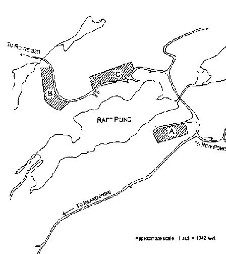
This report presents the results of a Stage 1 Historic Resources Impact Assessment in the Raft Pond, Mann Pond, and New Pond areas of proposed cottage developments. Archaeological assessment was completed for the following areas (See Figure 1): Raft Pond (A, B, C), Nothing Pond (E), New Pond (K, L, M, N), Pond A (G), and Mann Pond (H, I, J). As well, shoreline locations were also tested. Despite intensive surface and sub-surface investigation of these twelve areas, no evidence of cultural resource material was located.
Introduction
The cottage developments are situated south of Road 330 between Carmanville and Pinsent on the Island of Newfoundland (Figure 1).
A crew of four archaeologists accessed and checked the Raft Pond cottage development between May 23, 1997 and May 26, 1997. The remaining areas were checked between June 19, 1997 and June 24, 1997, once deeply rutted, muddy woods roads had stabilized.
The following paragraphs describe the study area, the field methodology, the results of the Stage 1 field assessment, and an evaluation and discussion of the results of this particular fieldwork.
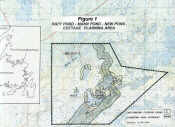
Figure 1. Raft Pond, Mann Pond, New Pond Cottage Planning Areas.
Description of Study Area
The study area is an interior boreal forest and bog landscape. Cabins currently exist only around the northeast end of Raft Pond. The roadways visible on aerial photos and on topographic maps throughout the study area are abandoned woods roads used only occasionally by local people today during autumn hunting. Bridges indicated on NTS 12H/4, the 1:50,000 scale topographic map for the area, are no longer in position; this includes the bridge crossing the Ragged Harbour River as it enters New Pond, and the bridge south of Mann Pond. The area was logged in the early twentieth century and currently non-commercial wood cutting continues during the winter season. Numerous decaying tree stumps occur within the boggy regions of the study area. As a general summary, the entire area is poorly drained bog with intermittent stands of trees. The study area is linked to the ocean by the Ragged Harbour River which has its headwaters at New Pond, flowing into Ragged Harbour. The distance from the ocean to New Pond is over ten kilometres of shallow, narrow waterway.
Much of the shoreline in the study areas is a steep, 80 degree incline, 1 – 2 metres from the water. Shoreline morphology generally consisted of dense cobble or boulder embankments. The land along the shore levels off and quickly transforms into poorly drained bog. There were no relict shorelines.
Methodology
Each cottage development area was visually and sub-surface surveyed. Considerable effort was made to test treed areas and bogs while also maintaining visual survey of erosion banks along shorelines. For the most part, the shorelines of the study area were cut banks with little beach edge. The inland portions of the cottage development areas were generally bog.
Results
Test areas are shown in Figures 1 and 2. No evidence of cultural material was found.
Aong Raft Pond, all cottage development areas (A, B, C) consisted of poorly drained, low-lying marsh. A few knolls were poorly drained as well. Bedrock outcrops occurred on all properties, as did glacial erratics. Shale and quartz fragments were common in all test pits. The average depth of each test unit was 30 cm except in areas of bedrock where test units were shallow.
The remaining test areas (E, G, H, I, J, K, L, M, N) consisted of rocky shorelines with poorly drained terrestrial regions.
Conclusions
In closing, extensive surface and sub-surface testing of Raft Pond, Nothing Pond, and the Mann Pond/New Pond development areas yielded no evidence of cultural resources.