
Archaeology in Newfoundland and Labrador 1997
Edited by K. Nelmes
Impact Assessment of a Proposed Duplex Site, Placentia, Newfoundland
Barry Gaulton and Matthew Carter
Introductory Statement
On October 23, 1997 an archaeological survey was conducted on a vacant lot soon to be a construction site for three duplexes at the corner of Riverside Drive and Blenheim Street in Placentia, Newfoundland. Due to its location between two other archaeological sites identified in 1996 (Gaulton and Carter, 1997), this area was deemed as a potential location for containing early French/English cultural remains. The survey area was tested by Barry Gaulton, Matthew Carter and three other crew members and involved excavating test pits at regular intervals throughout the site. The results show that the area contains a lot of material culture dating from the 17th century through to the 20th century, but that it is in a mostly mixed context. The following is a more detailed account of the proposed development and results of the archaeological impact assessment.
Proposed Development Project
A local contractor is proposing to build a group of three duplexes on the property at the corner of Riverside Drive and Blenheim Street in Placentia, Newfoundland. The land includes a riverside frontage measuring 30.6 by 36.5 metres and an additional connected parcel of land behind the senior citizens triplex measuring 19.7 by 27.4 metres. The proponent wishes to build the duplexes in an arrangement using just under a metre of fill to raise the area to the required height necessary in accordance with Town Council regulations. Because of this infilling, the site would require minimal subsurface disturbance and this would be only for laying the foundations and connecting water and sewer lines.
As will be discussed below, the only undisturbed stratigraphy found at this site was in two test pits at the northern end, with material dating to no earlier than the late 18th century. The deposit was found between 50-60 cm below the surface and was roughly 20 cm thick. Below this deposit was a sterile layer of small beach cobbles which continues down to the furthest tested depth of 1 metre. If there is any earlier cultural occupation below this cobble layer it would remain undisturbed by the nature of the above mentioned construction.
Depending upon the depth and location of the foundations and the water and sewer lines, the proposed development will have either a minimal effect or no effect on the late 18th century cultural layer in the north end of the site. The remainder of the site is disturbed by either recent sewer lines/septic systems and/or gardening activities and consists of one thick stratigraphic layer which contains a wide array of material culture dating from the 17th to 20th centuries. Therefore, this area is also clear for development.
Study Area
According to maps dating from the 18th century French occupation of Placentia, a large part of the riverside lands were utilized for mercantile premises and fishing establishments and likely included a variety of houses, storerooms and other structures. In 1996, a survey of one of the properties in this area (ChAl-6) uncovered a thick deposit of hard-packed black earth, iron, coal, brick and slag (Gaulton and Carter 1997). This deposit was likely the refuse from a nearby blacksmith shop which dates from the 18th century.
The proposed duplex site is one property south of ChAl-6 and therefore could also contain some cultural remains dating from the 18th century or earlier.
Methodology
As mentioned in the Proposed Development Project section of this report, this parcel of land consists of two connected units, one of which is at the corner of Riverside Drive and Blenheim Street (30.6 by 36.5 metres) and the other is behind the senior citizens triplex (19.7 by 27.4 metres). The land behind the triplex did not need to be surveyed because this building was once an old bank and the land behind it held a large vault which was set many feet underground. When this bank was being converted into a senior’s complex in 1996, the land was dug up by a backhoe and the vault removed.
This left only the first parcel of land on the corner of Riverside Drive and Blenheim Street. Surveying this area first involved measuring out the site (from a designated point in the far southeast corner of the property line) and then marking every five metre interval. At each of these marks a test pit (approx. 50 x 50 cm) was dug with both shovel and trowel down to a depth of 80-100 cm. Some areas of the site were impossible to test as both asphalt and thick rose bushes prevented any subsurface penetration. All visible stratigraphy was recorded in each test pit, along with the total depth and presence/absence of artifacts.
Results
The results of this survey show that the vast majority of the site contains stratigraphy which has been disturbed, and therefore construction in these areas will not impact on any historic resources. Except for two test pits, all other excavations revealed a basic stratigraphy consisting of an initial layer (0-20 cm dbs) of recent material and fill followed by a thick layer (20-80 cm dbs) of dark brown/black soil and cobbles which contained a variety of artifactual material dating from the 17th to 20th centuries. Below this was a layer of cobbles that continued down to a depth of at least 100 cm. In several cases, testing uncovered sewer pipes and septic tank disturbances at a depth of 60 cm.
The two test pits which contained an undisturbed late 18th to early 19th century occupation are located 15 metres west, 25 metres north; and 20 metres west, 20 metres north, of the far southeastern extent of the property line. These two test pits contained a mix of recent and disturbed layers down to 50-60 cm followed by a layer of undisturbed brown/black soil and cobbles. This layer was only 20-30 cm thick but contained many bricks and a scatter of late 18th to early 19th century artifacts. The earliest datable artifacts were several pieces of creamware which could not have been deposited on the site until at least the 1760s. Below this deposit, as seen in the other test pits, is a layer of small cobbles that continues down to an undetermined depth.
On the surface of this site we recorded a large gravestone bearing the name of John Hamilton, a resident of Placentia Bay who died on January 18th, 1826 (Figure 1). Several people have told the story of this man and how his grave marker had come to rest at this location. Apparently, when he had died this gravestone was made for him by a craftsman named Smyth in Waterford, Ireland (the inscription of the maker and the origin of the stone is still visible in the bottom corners). The stone was then sent over as ballast in a ship owned by a Placentia merchant named Sweetman. When the stone arrived in Placentia there must have been some problems with payment or otherwise, for instead of using it as a grave marker, the stone was used as a front doorstep for the merchant’s house!
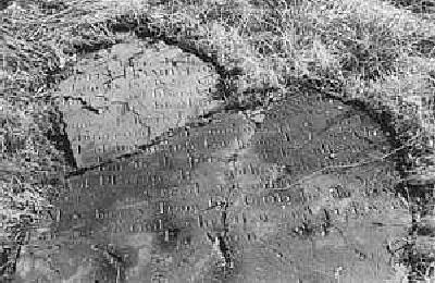
Figure 1. Gravestone bearing the name of John Hamilton (d. Jan. 18, 1826).
Both the stone and its story are a colourful chapter in the history of Placentia and this gravestone, which unfortunately is in a very fragile and fragmented state, should be carefully removed from the premises prior to any construction. Members of the Placentia Historic Society have been informed of this situation and hopefully it will be rectified soon.
The only other survey conducted in this area was in 1996 (Gaulton and Carter, 1997) and this revealed two areas of significance (Figure 2). One is to the south of the duplex site – the O’Reilly House (ChAl-5); and one is directly north – the Murray Property (ChAl-6). The O’Reilly House site, though mostly disturbed, did contain a large number of historic artifacts. Survey of the Murray Property revealed a thick deposit containing artifacts associated with an 18th century blacksmith shop.
The undisturbed late 18th- early 19th century deposit found on the land of the proposed duplex site will be given the Borden classification of ChAl-7 and all other artifacts found during this survey will also be classified under this number.
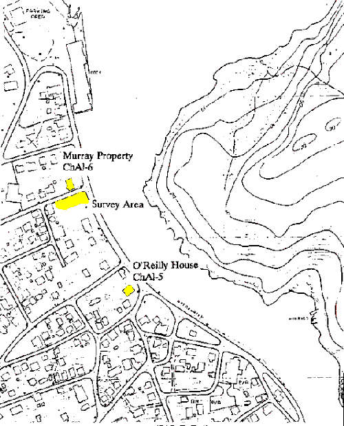
Figure 2. Map of the surrounding area, showing both the location of the Murray Property site (ChAl-6) and O’Reilly House (ChAl-5) in relation to the survey area.
Evaluation And Discussion
The survey conducted on the land at the corner of Riverside Drive and Blenheim Street in Placentia, Newfoundland revealed a great deal of subsurface disturbance and only two test pits provided evidence of an undisturbed deposit. Unfortunately, the disturbed nature of this area provides little insight into the past history of Placentia and its people. Given the fact that these duplexes are to be built on a thick layer of fill, subsurface intrusion would likely be on a minimal level. Construction in this location would thus result in little or no disturbance of Placentia’s historic resources.
References Cited
Gaulton, Barry and Matthew Carter
1997 – “Placentia Archaeological Survey – 1996.” Report on file at the Culture and Heritage Division, Department of Tourism, Culture and Recreation, Government of Newfoundland and Labrador, St. John’s.
Proulx, Jean-Pierre
1979 – “The Military History of Placentia 1713-1811.” History and Archaeology 26, National Historic Parks and Sites Branch, Parks Canada, Environment Canada.