
Archaeology in Newfoundland and Labrador 1997
Edited by K. Nelmes
Baccalieu Trail Archaeology Project, 1997: Excavations at Cupids
William Gilbert
Introduction
The 1995 and 1996 Field Seasons
During the summer of 1995 the Baccalieu Trail Heritage Corporation conducted an eight week archaeological survey and excavation in the community of Cupids, Conception Bay, the goal of which was to determine the location and state of preservation of the Cupers Cove plantation established there in 1610 by the London and Bristol Company of Merchant Venturers (Gilbert 1996). This plantation, whose first governor was Bristol merchant and adventurer John Guy, was the first official colony established in Newfoundland, the first English colony established in what is now Canada, and one of the first European colonies established in North America.
A number of documents related to the plantation, including a diary, a journal and 19 letters, all written in Newfoundland between 1610 and 1631, have survived and it was to these that we turned for clues to the site’s location before beginning our survey. From these documents we learned that Cupers Cove had stood 240 paces (or twelve score) from Cupids Pond, near a brook and on the landward side of the salt water pond that lies at the bottom of Cupids harbour (Gilbert 1996:68-70). Taken together, these three clues defined an area measuring roughly 500 metres from east to west at the bottom of Cupids harbour within the boundaries of which the plantation had once been located (Figure 1).
At the extreme eastern end of our survey area the land rises roughly four metres above the low ground to the west to form a dry level terrace (Figure 2). An initial examination of this area produced a range of 17th century material (ceramics, glass, clay pipe fragments, etc) in the soil thrown up by a tree fall on its western edge. Some of this material, including clay pipe stem fragments with 9/64 and 8/64 stem diameters, suggested that at least part of this deposit dated to the first half of the 17th century. Testing conducted on the terrace itself defined an area measuring roughly 52 x 28 m that contained early to mid-17th century material.
Having defined the area, we opened and excavated a 1 x 10 m test trench running from north to south within its boundaries. This trench produced roughly 5000 artifacts, the majority of which were of 17th century origin. Part of a stone and brick feature (Feature 1) running diagonally across the trench was also uncovered. The feature appeared to be a fireplace and analysis of the material associated with it suggested that it was part of a structure built sometime prior to 1620, occupied during the first half of the 17th century and destroyed sometime between 1650 and 1680 (Gilbert 1995;88-94). Documentary, archaeological and architectural evidence all combined to suggest that this structure was part of the original Cupers Cove plantation.
During the summer of 1996 we returned to Cupids and conducted a further ten weeks of excavation expanding the original 1 x 10 m trench 1 m to the east and 1 m to the west and creating a 3 x 10 m excavation unit. This allowed us both to determine the nature of the feature and its orientation and, by acquiring a larger sample of artifacts, to date it more accurately (Gilbert 1997).
Our original hypothesis was greatly strengthened as a result of this work. Feature 1 was indeed a fireplace, and fragments of the last wood to be burnt there, including numerous charred spruce and fir needles, were still present in the brick lined firebox. It was also obvious that this fireplace had once been part of a wooden structure (Structure 1) which had suffered considerable fire damage. Extending northeast away from the fireplace were the burnt remains of a wooden sill and floor boards.
By the end of the 1996 season roughly 12,000 artifacts had been recovered. An analysis of these artifacts reinforced earlier speculations that Structure 1 was built prior to 1620 and occupied during the first half of the 17th century. New material recovered from the destruction level allowed us to narrow down the destruction date and indicated that the building was probably destroyed sometime between about 1650 and 1665. Material recovered from the post-destruction level showed that the area to the east of Structure 1 had continued to be used during the second half of the 17th century after the destruction of Structure 1.
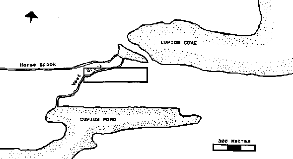
Figure 1. The original survey area as defined by information contained in the contemporary documents.
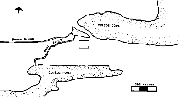
Figure 2. The survey area after the low ground to the west had been eliminated.
The 1997 Excavation
In 1997 we returned to Cupids to conduct a further fifteen weeks (30 June – 10 October) of excavation. Having determined the orientation of Structure 1, our next goal was to expose as much of the building as possible. To this end, we extended our 3 x 10 m excavation east a further three metres creating a total excavation area of 6 x 10 m. The 3 x 10 m extension was designated Operation 4. We reasoned that if Structure 1 measured approximately 7.31 x 3.64 m), then Operation 4 should encompass most of its remaining area. Later we discovered that we had both underestimated the size of Structure 1 and failed to allow for the possibility of other adjoining structures. As a result, it proved necessary to extend our excavation east for another 5 m at the north end and 6 m at the south end of Operation 4.
The Structures
When we removed the rubble from the southern end of Operation 4, we uncovered the remainder of the fireplace first discovered in 1995. Constructed mainly of stone, it measures 3.5 m wide (from northwest to southeast) by 1.6 m deep and contains a brick lined firebox 1.65 m wide and 95 cm deep with a floor of flat stones. Burnt wood and ash from a fire lit in the western half of the fireplace some time before the building’s destruction were still present beneath the rubble. As was the case in 1996, thousands of charred coniferous needles were found in the fire’s ashes and an analysis of these indicates that the last fire kindled there was made mostly of spruce along with some fir (Mike Deal, personal communication). Since so many needles have survived, it seems clear that much of the wood used in the fire was green and the fact that it was confined to the western half of the hearth suggests it was probably lit at a time when the weather was relatively mild.
That portion of the floor sealed beneath the rubble overburden had, indeed, burned and its charred remains were clearly visible once the rubble was removed to the north of the fireplace. The burnt sill extended northeast for 5.1 m and its northern and southern ends rested on large flat stones that seem to have served as ‘sill plates.’ In places the burned floorboards could still be seen running northeast to southwest parallel to the sill inside the structure. Those boards that survived measure, on average, 27 cm wide. However, they undoubtedly shrank during the fire and originally must have been somewhat wider. When we take into account the gaps between the boards, we arrive at a measurement of just slightly over 32 cm. Assuming, as seems likely, that the floorboards were originally placed tight together, then they probably measured about 32 cm across prior to shrinkage. Farther east, ploughing had eradicated any evidence of floorboards but traces of the underlying joists remained extending southeast away from, and perpendicular to the sill. Portions of five of these joists survived. They had been placed 61 cm apart and the longest surviving example was 3.9 m long.
Assuming that the longest remaining joist accurately represents the maximum width of Structure 1, then the fireplace originally opened up into and heated a room measuring roughly 16 ft x 12 ft with a wooden floor constructed of 12 inch wide planks placed over joists set 2 ft apart. This was one of two rooms that made up Structure 1. The second was located to the north of and adjoining the first and it proved necessary to expand our excavation to the north and east to expose it.
Twenty-five cm northeast of the northern sill plate, we uncovered part of a cobblestone surface perfectly aligned with the burnt sill. These cobbles were clearly part of Structure 1, however only a 1.18 m section was contained within the perimeter of Operation 4. To uncover the rest, we first established an operation (Operation 6) measuring 4 m from north to south and 3 m from east to west adjoining and extending 2 m north and 3 m east of Operation 4. Later, we expanded our excavation 2 m farther east and establish another operation (Operation 8) adjoining Operation 6 to expose the rest of Structure 1.
Unlike the southern half of Structure 1, there was no well defined rubble deposit this far north. Instead, the north end was overlaid by an undifferentiated deposit of brown silt measuring, on average, 28 cm thick and containing mostly 17th century material and some late 18th/early 19th century material. Obviously there had been considerable disturbance in this area after the destruction of Structure 1 and apparently this was caused by a combination of ploughing in the latter period and either intentional destruction or the salvaging of stone during the former. Fortunately, most of the northern half of Structure 1 had been solidly constructed and survived this activity. The only direct evidence of the destruction of Structure 1 in this area was occasional burnt timbers resting directly above the floor. When the overlying burden of silt and burnt wood was removed an elaborate construction of cobblestones, flagstones and stone walls was revealed.
The cobblestones first exposed in Operation 4 extend northeast for 3.6 m forming a walkway 70 cm wide. To the east are what appear to be two small chambers with cobble and flagstone floors divided from northeast to southwest by a low, well made stone wall measuring 55 cm across. A second stone wall measuring 2.4 m long and 60 cm wide runs perpendicular to the first just north of it and forms the north end of Structure 1. A second cobble walkway of roughly equal length and width seems to have once existed parallel to the first on the opposite side of the chambers but was largely destroyed probably some time towards the end of the 17th century. While the exact nature of these chambers is as yet unknown they most likely served as either a storage or service area for Structure 1.
Beneath the overburden of silt to the northwest of this area (in Operations 4 and 6) we uncovered a jumble of burnt timbers that were obviously related to the destruction of Structure 1. When these were removed other timbers were revealed that displayed a much more coherent pattern. Abutting the cobblestone walkway and running parallel to it along its entire length is a timber that is obviously an extension of the burnt sill farther to the south. Two other timbers run parallel to the sill, the first 38 cm northwest of it, and the second 55 cm northwest of the first. Overlaying and running perpendicular to these timbers are traces of what appear to be floor boards. Only a small portion of these timbers was exposed in 1997. However, they are almost certainly the remains of another wooden floor and appear to be either an extension of Structure 1 or an adjoining building running perpendicular to it.
As mentioned above, much of the southern end of Operation 4 was covered in rubble and in most places this deposit was about 25 cm thick. However, this was not the case southeast of the fireplace. Digging here revealed a 30 cm wide stone wall adjoining the southeastern corner of the fireplace and extending southwest away from it. On the western side of this wall we encountered the typical destruction and occupation levels found elsewhere on the site but on the eastern side the rubble continued down to a surprising depth.
Here, loose rubble extended north from the southern boundary of Operation 4 for a maximum distance of 1.7 m and east and south beyond the perimeter of Operation 4 for an unknown distance. Once this rubble had been removed to a depth of roughly 1 metre below the surface, the south and east profiles became so unstable that any further digging would have caused them to collapse. Rather than risk this, we established an operation (Operation 5) extending 4 m north and 2 m east of the southeast corner of Operation 4 in an effort to find the eastern boundary of the rubble. However, we soon discovered that the loose rubble extended east beyond the boundaries of Operation 5 and a third operation (Operation 7) was created measuring 2 m from north to south and extending east for another 5 m. It was in Operation 7 that we finally located the eastern edge of the rubble.
At this point it was obvious that we were dealing with a rubble-filled pit. That portion of the pit encompassed by our excavations extended east from the stone wall adjoining Structure 1 for 6 m and north from the southern boundary of our excavation for 2.8 m. How far south it extended we had no way of knowing. Most of the pit was filled with loose rubble. However, around the edges the rubble was enclosed in a matrix of brown silt. Once all the loose rubble to the east, north and west had been removed to a depth of 1 m, we reinforced the south profile to keep it from collapsing and continued digging down.
Although it seemed clear that this pit was contemporaneous with Structure 1, much of the material contained in the loose rubble that filled it clearly dated to sometime around the late 18th century or early 19th centuries. Numerous fragments of creamware and pearlware were recovered along with late 18th/early 19th century bottle glass. The reason for this apparent anomaly became clear as we continued to dig. At a depth below surface of just over 1 m we encountered a deposit of fine brown silt that was, on average, 25 cm thick and beneath which were the remains of two stone walls. The walls, on average 30 cm wide and constructed of a combination of fieldstones and cut stones, come together at a right angle to form a corner and are perfectly aligned with the walls of Structure 1. Between the walls was a second rubble deposit in a silt matrix which contained early to mid-17th century material and beneath which, at a depth of 2.13 m, was a floor of hard packed grey sand and gravel.
It now seemed clear that we had uncovered the remains of a collapsed cellar adjoining and contemporaneous with Structure 1. Originally, the cellar probably had been walled with stone all the way to the surface. Apparently, it was abandoned after the destruction of Structure 1 and the upper courses of the walls gradually fell in reinforcing the lower courses and preventing them from collapsing. Over the next 100 or so years the pit remaining after this collapse silted and sodded over and by the late 18th century all that remained was a sod lined depression. Then, sometime around 1800, somebody must have filled the depression with loose rubble, perhaps as a safety precaution.
Like Structure 1 the cellar runs at roughly a 45 degree angle to the site grid and extends southwest away from Structure 1 for an unknown distance. Only a corner has been exposed to date and until further excavations are conducted we have no way of knowing either its total length or width. The corner that is exposed extends north from the southern boundary of our excavation for 1.7 m and the maximum distance between the walls, at the southern end of the excavation, is 3.15 m. Since the section of the north wall that is exposed is 2.3 m long and that of the west wall is 2.15 m long, we know that the dimensions of the cellar must be somewhat greater than this but how much greater we cannot as yet say. A substantial portion of the walls have survived. The north wall rises to a maximum height of 65 cm and the west wall to 89 cm.
Structure 1 is not unlike many buildings that have either survived or been excavated from the late Medieval and early modern periods. Measuring 11.1 m long by approximately 3.9 m wide, it was divided into two main units. At the southern end was a 16 ft x 12 ft room with a wooden floor heated by a large stone fireplace with a brick lined firebox. At the north end is what appears to have been a storage area with a cobble and flagstone floor divided by a stone wall into two separate chambers. Such a building would not have been out of place in Britain during the 16th and 17th centuries. Houses during this time often consisted of no more than two rooms. The upper room with the hearth, usually referred to as the ‘hall,’ was where the inhabitants lived, ate and slept. Sometimes, the lower room served as a bier for farm animals but more often the animals were housed in a free standing barn and the lower room served as a service or storage area. In many cases this area was further divided into a buttery and a pantry. The hall and service area were frequently separated by a cross-passage running perpendicular to the long axis of the structure at one end of which was the entrance (Quiney 1990:77-89). Whether or not Structure 1 had such a cross-passage we cannot as yet say.
In rural parts of England cellars were apparently rare during this period although they were much more common in urban homes, especially in the homes of merchants. This is understandable given the relatively mild English winters. However, it is hard to imagine how supplies could have been preserved during the long, hard Newfoundland winter without resorting to a cellar of some kind. Certainly, cellars were a part of vernacular New England architecture from quite early on and some of the earliest houses excavated in New England include them (Deetz 1977:95-98).
Destruction
Rarely does one find enough fragments of a particular vessel on a living site to permit a reconstruction. Activity both during and after the occupation usually disperses the pieces over a wide area leaving the archaeologist to identify complete vessels using only the few sherds that remain. However, the destruction level that sealed and preserved a portion of Structure 1’s burnt floor also sealed and preserved, in a semi-articulated state, a number of the vessels that were in the building when it was destroyed.
A minimum vessel count conducted on the ceramics from the destruction level indicates that there were at least 45 vessels in Structure 1 when it was destroyed. Of these, a surprisingly high number (at least twenty) were of Iberian origin. These include fragments of fourteen different tin-glazed earthenware vessels which had previous been identified as English delftware (Gilbert 1996, 1997). However, an analysis of these fragments by John Allan of the Exeter Museums in Devon has shown them all to be of either Spanish or Portuguese manufacture and of a type generally referred to as Iberian blue and white (John Allan, personal communication). Many of these vessels were so fractured by the immense weight of the chimney collapse that the fragments were too small for us to determine vessel type. However, they include at least three small bowls and a shallow dish. Fragments of six Spanish Merida ware vessels were also present including two bottles, one jug and an amphora.
Not surprisingly, various types of West Country wares were also recovered from inside the house. The majority of these were storage jars, and fragments of at least eleven were inside Structure 1 when it was destroyed. Of these, three were manufactured in north Devon, three in south Devon at Totnes near Dartmouth, and five in south Somerset. Fragments of three tall pots, used for storing butter, were also found in the house, all of which were the work of north Devon potters. Other vessels inside Structure 1 include at least four German manufactured Rhenish stoneware Bellarmines and portions of two large bowls. The latter have not yet been identified but may have been manufactured in southeastern England, perhaps around the London area.
Three small fragments of French Saintonge, possibly all from the same vessel, and a single fragment of Italian Sgrafitto ware, probably manufactured in Pisa (John Allan, personal commmunication), were also recovered from the destruction level. While these last vessels were probably broken inside Structure 19 the few fragments recovered suggest that this happened sometime prior to the destruction and that most of the pieces were discarded elsewhere while the building was still occupied. A number of other fragments of Saintonge, including the spout from a barrel costrel, have been found to the east and west outside Structure 1 and a fragment of Italian Sgrafitto, very similar to the one from inside Structure 1 was found just east of the cellar.
Several iron implements were also recovered from inside the structure including a shallow iron bowl and a 17th century axe head, both resting on the floor in front of the fireplace. Two metres to the north were the badly corroded remains of a reaphook, or sickle, and at the north end of the building were three 17th century iron keys. Of these, one was resting on the cobblestones inside the house, another was lying just west of the cobblestones and the third was found just outside the building to the north. Another two keys were found farther east just outside Structure 1. South of the cobblestone floor were three cast iron cannon balls: a four pounder, a five pounder and a six pounder. Literally hundreds of wrought iron nails, almost certainly left from the collapse of the building’s wooden superstructure, were also recovered from the destruction level.
Four types of glass were found in the destruction level: window glass, case bottle glass, onion bottle glass, and glass beads. Of these, window glass was the most common and literally thousands of small fragments were recovered. Hundreds of fragments of case bottle glass were also present and, while the exact number of case bottles is impossible to determine, the presence of two bases in the upper room and a rim and shoulder fragment at the back of the hearth indicates that there were at least three such bottles in the house when it was destroyed. Only a few fragments of onion bottle glass were recovered and these may all be from a single bottle.
Seven glass beads have been found in the destruction level over the past three seasons. Four of these are the typical bright blue beads, usually identified as trade beads on 17th century sites, and the other three are of a type generally referred to as ‘chevron’ beads. Roughly cylindrical with a layer of dark blue glass over layers of red, white and yellow, the ends of these chevron beads have been ground down exposing the different colours and creating a layered effect. According to Ivor Noel Hume such beads are usually found on colonial sites dating to the first half of the 17th century (Noel Hume 1969:53). Similar beads have been recovered from a 16th/17th century context at the Woolster Street excavations in Plymouth, Devon (Gaskell-Brown 1986:39-40 & 50 #173-176). Of the three chevron beads found in Structure 1, one was resting on the cobblestones at the north end of the house and another was directly above one of the burnt timbers extending northwest from the north end of the house. The third, also located at the north end of the house, obviously had been caught between two burning timbers, partially melted and flattened during the intense heat of the fire. Three other chevrons were found at the north end of the building but, unfortunately, were from a disturbed context.
Based on the results of the 1995 and 1996 seasons, we concluded that Structure 1 probably had been destroyed sometime between about 1650 and the early 1660s (Gilbert 1997). A reanalysis of this data combined with new data recovered in 1997 suggests that a more accurate date for the destruction is sometime in the early to mid 1660s. While most of the material recovered from the destruction level was almost certainly manufactured prior to 1660, several of the clay pipes indicate a slightly later date.
Certainly, the bottle glass found in the destruction level suggests a date of 1660 or before. Case bottles were the only type of glass bottle manufactured by the English prior to 1645 and, while they continued to be manufactured after that time, they were increasingly displaced as time went on, first by onion bottles and later by dark green wine bottles (Noel Hume 1979:42-43). Onion bottles first appeared around 1645 and were themselves largely replaced by dark green wine bottles by about 1660 (Noel Hume 1969:63; 1979:42-43). If Structure 1 had been occupied much after the latter date, dark green wine bottle glass undoubtedly would have been present in the destruction level but it was not. However, dark green bottle glass was present on the site in the post-destruction level both above Structure 1 and to the east of it. As we have seen, the glass chevron beads also suggest a date from the first half of the 17th century. Ceramic evidence also points to an occupation ending no later than about 1660. Most of the west country vessels recovered from the building have a fairly broad temporal range and, while clearly of 17th century origin, are of little other use as dating tools. Nor is the Merida ware of much use in dating the destruction. However, some of the other pottery is much more period-specific. All of the Iberian blue and white tin glaze recovered from Structure 1 dates to the first half of the 17th century as does the single fragment of Italian Sgrafitto (John Allan, personal communication). The four bellarmines found inside the building could be of a somewhat later date. However, all are of mid-17th century origin (John Allan, personal communication) and could easily have been manufactured before 1660.
All of this points to a destruction date of 1660 or before. However, one pipe bowl and a pipe bowl fragment recovered from the occupation level were almost certainly manufactured somewhat later. Three diagnostic pipe bowls and a pipe bowl fragment have been recovered from the destruction level. Two of the bowls have no maker’s marks but one was obviously produced sometime between roughly 1620 and 1660 and the other between about 1650 and 1680 (Gilbert 1997:13 & 30-31) suggesting a destruction date of roughly 1650 to 1660 – the period when both these types of pipes were in use. The third bowl, discovered in 1997 resting beneath a burnt timber on the cobblestones at the north end of Structure 1 bears the maker’s mark ‘IA’ on its heel and is identical to Bristol pipes assigned by Iain Walker to the period 1660-1670 (Walker 1977:1462-1463, C,D,E). Apparently, the only Bristol pipe maker with the initials ‘IA’ working during this period was John Abbott whose career spanned the years 1651 to 1681 (Oswald 1975:150). This is almost certainly one of his pipes and, based on stylistic evidence, was probably made sometime between about 1660 and 1670. Too little of the fourth bowl fragment has survived for it to be identified by shape. However, it has the maker’s mark ‘IT’ on its heel and is apparently the work of Bristol pipe maker John Tucker who was active between 1662 and 1687 (Oswald 1975:158; Gilbert 1997:13).
While the ‘IA’ pipe could have been made as early as 1660, if the ‘IT’ pipe is the work of John Tucker, then Structure 1 still must have been standing in 1662 when Tucker began his career. Yet, given that all the other datable material inside Structure 1 seems to date to 1660 or before, it seems unlikely that the building survived much after that time.
Occupation
It seems clear that Structure 1 was occupied during the first half of the 17th century, but exactly how long was it occupied and when was it built? To answer this question we need to look outside the structure and below the destruction level to the deposit that accumulated around the building during its construction and occupation. Unless the building was occupied for only a short period, most of the material inside it probably dates from close to the end of the occupation. It is highly unlikely that broken glass and pottery would have been left lying around on the floor of a house that was in regular use. However, material lost or discarded during the occupation of the building would have accumulated outside it and we are fortunate in that Structure 1 has a well defined and easily identified occupation level (Level 4) outside the structure and immediately below the rubble and burnt timbers of the destruction level. Most of the occupation level excavated to date is just west of and adjoining Structure 1 around the area where the entrance appears to have been located.
As we have seen, the destruction level consists of stone and brick rubble in a silt matrix. In contrast, the occupation level which lies beneath it is made up of a fine brown silt with very little rubble. Aside from these obvious differences in matrix, the destruction and occupation levels differ in another fundamental way. While the ceramic from the destruction level is made up mostly of relatively large fragments, many of which join to form partial reconstructions, the ceramic in the occupation level consists mostly of smaller fragments with very few joins. This reflects the fundamental difference between these two deposits. The destruction level represents a single event – the destruction of Structure 1 – which took place in a fairly short time and which remained relatively undisturbed until we uncovered it. In contrast, the occupation level accumulated gradually around Structure 1 over the period that the building was occupied. Vessels, both of ceramic and glass, undoubtedly were broken outside the building during that time but most of the fragments would have either been collected and discarded elsewhere or knocked about by later activity leaving only those few that escaped to enter the archaeological record. There are also some other significant differences between the artifacts from the occupation level and those from the destruction level.
Four types of glass were recovered from the occupation level: 17th century window glass, case bottle glass, trade beads and blue-green glass. Of these, window glass was the most common and much of it was located directly outside Structure 1 at the base of the burnt sill. Case bottle glass was the next most common type and the only type of bottle glass in the deposit. Most of the fragments were small, which should come as no surprise given the fragility of these bottles. However, a well preserved rim and shoulder fragment was recovered from the north end of the structure near the base of the sill. Seven glass beads, almost certainly trade beads, were recovered. Of these, three are cylindrical blue beads, one is a round blue bead, three are round white beads and one is a round black bead with four white stripes. Only a few small fragments of 17th century blue-green glass were recovered, possibly all from one vessel. This glass is typical of glass manufactured in the Low Countries in the early to mid-17th century.
The window glass and its location just outside the burnt sill suggests that Structure 1 had glazed windows. The glass most likely accumulated over time as panes were broken and replaced. The presence of case bottle glass to the exclusion of any other type clearly points to an occupation during the first half of the 17th century. Indeed, since no onion bottle fragments have been recovered from this level, an occupation date of sometime prior to 1645 is strongly suggested.
The presence of trade beads also points to an early date for the occupation level. We know that up until at least 1620 the planters at Cupers Cove were making a concerted effort to establish a fur trade with the Beothuk Indians living to the west in Trinity Bay and a number of trips were made into the bay for that purpose. Among the items used in this trade were beads and there are two references to trade beads in the early documents from the plantation. Guy mentions that he took a number of amber beads with him on his voyage into Trinity Bay in the fall of 1612 and left several at a Beothuk camp on Dildo Pond (Gilbert 1990:154). Later, in 1619, Thomas Rowley included beads in a list of items to be used as ‘Truck for savages’ in Trinity Bay (Gilbert 1992:7). A total of 87 beads have been found at Cupids to date and most, if not all, are almost certainly trade beads. Unfortunately, many have been disturbed from their original context as a result of ploughing and frost action and cannot be dated stratigraphically. However, one in particular is worthy of special mention. In Operation 7, just east of Structure 1, we found a cylindrical amber bead measuring 1.25 cm long and 0.71 cm wide. Such beads are extremely rare on archaeological sites and while we may never know for certain, it is possible that this is one of the amber beads mentioned by John Guy.
Ceramic evidence also points to an occupation beginning early in the 17th century. There are certainly similarities between the ceramics from the occupation level and the destruction level. Fragments of Iberian vessels are common, including a few examples of Iberian blue and white tin glaze, dating from the first half of the 17th century, and a number of pieces of Merida ware including fragments of two Merida trefoil jugs. West country wares are also present, among which are a number of sherds of South Somerset and North Devon ware, including the burnt rim of a North Devon ware storage Jar. A number of fragments of Saintonge have also been recovered.
However, several types of pottery have been found in the occupation level that were absent from the destruction level and point to an occupation beginning early in the 17th century. These include a number of fragments of a grey micaceous earthenware believed to be of either Breton or Norman manufacture, an English delftware apothecary jar, or ‘albarello,’ with a hand painted blue and yellow design, and three fragments of Werra Slipware. The grey micaceous earthenware is identical to examples recovered at Ferryland in a pre-1621 context and is usually assumed to be of 16th century origin (Gaulton 1997:4-5; James Tuck, personal communication); the albarello, found just south of Structure 1 near the back of the fireplace, was manufactured in London sometime between 16l2 and 1640 (Gilbert 1997:19-20; Drey 1978:115; Noel Hume 1977:26-27, 64-65); and the Werra Slipware was made in Germany sometime between 1575 and 1625 (John Allan, personal communication).
As is usually the case, our best indicators of age are clay pipes, and eleven diagnostic pipe bowls have been recovered from the occupation level to date. Nine of these came from the area to the west of Structure 1, in Operations 1, 2, 3 & 4, and the remaining two came from just east of the structure in Operation 7. These pipes range in date from roughly 1610 to 1650. Six are of types manufactured between roughly 1620 and 1650. Another is a Dutch pipe with a five-leaved rose pattern in relief on one side of the bowl also manufactured sometime between 1620 and 1650 (Oswald 1969:140-141). Yet another has a maker’s mark consisting of a cross stamped in relief on its heel which resembles marks found on London pipes dating to between 1620 and 1640 (Oswald 1975:66; Gilbert 1996:18-19). The final three are extremely early and date to the earliest occupation of the site. These are of a type assigned by Noel Hume (1969:303) to between 1580 and 1620 and by Oswald (1975:37-39) to between 1580 and 1610 (Gilbert 1997:29). If Oswald’s dates are correct, these pipes date to the very beginning of settlement at Cupids in 1610 and indicate that Structure 1 was built about that time. If Noel Hume’s dates are the more accurate, then these pipes were still manufactured no later than 1620 and indicate a construction date of 1620 or before.
Three other early 17th century pipe bowls and a pipe bowl fragment also have been recovered at the site and, while they are from a disturbed context, it is worth noting that all three of the bowls have a date range of between roughly 1620 and 1650. The bowl fragment, found in the ploughed area on the eastern side of Structure 1, is especially interesting. It has a distinctive rosette design stamped on the back of the bowl which is identical to marks found on clay pipes excavated at Plymouth and dating to between 1590 and 1630. Pipes with similar marks have also been excavated at Bristol where they date to between 1630 and 1640 (Oswald 1969:127-129).
Post-Destruction
It was clear from our work in 1995 and 1996 that there had been considerable post-destruction activity in the area around Structure 1 during the latter half of the 17th century and this is certainly supported by our findings in 1997. Ceramics, bottle glass and clay pipe fragments from this period have all been recovered both from the post-destruction level and from a disturbed area to the east of Structure 1. Indeed, it appears that most of the post-destruction activity, at least during the 17th century, took place to the east of the structure.
Five clay pipes bearing the ‘PE’ maker’s mark of Philip Edwards have been recovered from the post destruction level. Edwards was a Bristol pipe maker who worked between 1649 and 1669 (Walker 1977:1420-1423) and the presence of his pipes above the destruction level not only indicates post-destruction activity but clearly shows that Structure 1 was no longer standing in the late 1660s. Even if all of these ‘PE’ pipes were manufactured at the very end of Edwards’ career, which is clearly not the case based on differences in design between these five pipes, Structure 1 must still have been destroyed by 1669 at the latest.
Based on the results of our previous work we had suggested that most of the 17th century post-destruction activity around Structure 1 had taken place prior to 1680. However, new evidence recovered during 1997 indicates that the post-destruction activity continued until at least 1690 or somewhat later.
A total of 39 diagnostic clay pipe bowls have been recovered from Cupids over the past three years and all but one clearly date from the 17th century. The one possible exception is a pipe recovered from a disturbed context just east of the north end of Structure 1 that was manufactured in the West Country, possibly in Exeter, sometime between 1690 and 1720 (John Allan 1984:280-261, & personal communication).
A somewhat later date for the post-destruction activity is also Westerwald tankards, one from the post-destruction level above the cobblestones and the other from the area east of Structure 1 were recovered and both have a date range of between 1680 and 1710 (John Allan, personal communication). Several of the bottle necks recovered from the area east of Structure 1 also clearly date from about the end of the 17th century.
Conclusions
Documentary, archaeological and architectural evidence all combine to indicate that the structures uncovered at Cupids over the past three years are part of the original Cupers Cove plantation. Certainly, they are in the right location. Indeed, if the information contained in the letters and diaries of the people who settled Cupers Cove is correct, they are in the only possible location. The site is 240 paces from Cupids Pond, on the landward side of the salt water pond, and adjacent to the original river bed, just as the documents say it should be. Although one could argue that it is possible to move farther to the east or west and still be 240 paces from Cupids Pond, it should be borne in mind that up until 100 or so years ago the land to the west of the terrace was a marsh and totally unsuitable for settlement and, while the land farther east is both level and dry, if ones moves much farther in that direction one is no longer either near the brook or on the landward side of the salt water pond.
At this point it is worth noting the significance of the salt water pond. This ‘pond’ is in reality not a pond but a natural haven and the most sheltered part of Cupids Cove. Located at the very bottom of the Cove, it is protected from winds and seas by a wide barachois beach that extends northwest from the south side virtually cutting it off from the rest of the harbour. However, there is a passage on the north side and it is through this passage that the boats of Cupids pass to find shelter for the night. This is the case now and it was undoubtedly the case in the 17th century.
When Guy’s party arrived in 1610 they almost certainly moored in the ‘pond’; later, Guy’s bark, the ‘Endeavour,’ and the colony’s fishing shallops would have anchored there, as would any vessels visiting Cupers Cove; and the colony’s boat building operations would undoubtedly have been located there as well. In a very real sense the pond was the centre of 17th century Cupids Cove as, in many ways, it is today, and the plantation would of necessity have been built adjacent to it just as the documents say it was.
As we have seen, the land at the bottom of the harbour west of the terrace on which the site is located was originally mostly marsh and, while the brook that passed through it provided a much needed source of fresh water, it was totally unsuitable for settlement. The nearest dry, level land to the pond is the terrace. Indeed, of all the land in this area, the terrace and the land sloping away from it to the east are by far the best suited for both settlement and agriculture and undoubtedly were heavily forested when Guy’s party arrived. Clearly, when these first colonists landed at the bottom of Cupids harbour in August of 1610, they selected the nearest piece of dry, level land close to a source of fresh water they could find to begin their plantation.
The archaeological evidence clearly indicates that the site is from the right period. While we cannot as yet say exactly when Structure 1 and its adjoining cellar were built, it seems clear they were built sometime between 1610 and 1620. In fact, many of the artifacts recovered from the occupation level, such as the Werra Slipware, grey-micaceous earthenware, Iberian blue and white tin glaze, and a number of the clay pipes could well date before 1610, although an earlier date is highly unlikely given their location and context.
Even if Structure 1 was built as late as 1620, it still fits well within the appropriate time range for the plantation. When Guy’s party arrived in 1610, they immediately set to work cutting and/or constructing the first buildings, and this work continued for a number of years. Henry Crout reported in August 1612 that all of Guy’s carpenters were busy building a “sawe myll and other houses” (Crout to Willoughby, 27 August, 1612, Mi X 1/15). A fort was also completed in the summer of 1612 to defend the plantation against pirates (John Slany to Willoughby, 3 September 1612, Mi X 1/18) and by 8 September of the same year work had begun on a house for Crout and his ward Thomas Willoughby (Crout to Willoughby, 8 September 1612, Mi X 1/20). By the spring of 1613 at least sixteen structures were standing at Cupers Cove and more buildings were almost certainly added after that. [1]
Indeed, the plantation was still a going concern in the mid-1620s. In 1624 William Alexander reported that, “The first houses for habitation were built in Cupids Cove within the Bay of Conception where people did dwell for sundry yeeres together, and some well satisfied both for pleasure, and profit are dwelling there still, finding small difference between the seasons of the yeere in that Climate, and here” (Alexander 1624:24). Perhaps the most interesting thing about the structures uncovered so far is not that they were built at such an early date but that, as the archaeological evidence clearly shows, they continued to be used for such a long time after that date.
The architecture is also what one would expect to find during the early days of the plantation. These buildings were clearly not the work of migratory fishermen whose premises invariably consisted of insubstantial structures adjacent to the water (Faulkner 1985). Instead, whoever built the massive stone fireplace, wooden, and cobblestone floors, and seven foot deep stone-walled cellar uncovered at Cupids was obviously planning a long stay. Nor is this likely to have been the work of an ordinary planter. The stonework is clearly that of a professional mason and it, along with features such as the wooden floor and glazed windows, suggests a level of affluence beyond the means of the average 17th century settler. However, it is certainly not beyond the means of an official colony backed by a consortium of merchants and nobles. In fact, we know that the London and Bristol Company hired professional sawyers, carpenters, stonemasons and other tradesmen and brought them to Cupers Cove specifically to build the plantation and as we have seen, the structures at Cupids resemble buildings constructed in England during the early 17th century.
It is also worth noting the similarities between the buildings at Cupids and some of the earliest buildings constructed at Ferryland. One of the first things the planters at Ferryland did upon their arrival on 4 August, 1621 was dig a cellar (Cell 1982:256). According to Edward Wynne, the first governor of the Ferryland colony, the cellar, which had been dug by 26 August and enclosed by 31 October, was twenty feet long and fifteen feet wide. Although he does not specify its depth, it must have been fairly deep since the earth from it and a nearby ‘kitchen room’ was used to construct an earthenworks defensive wall. This cellar was part of a larger structure, 44 feet long and 15 feet wide, that included a hall 18 feet long and 15 feet wide, with ‘one Chimney of stone-worke’ and a six foot wide entryway (Cell 1982:196-197). We do not as yet know the dimensions of the cellar at Cupids but, as we have seen, the hall has a single stone chimney and measures sixteen feet by twelve feet – only slightly smaller than the one built by Wynne. The ground floor of the structure at Ferryland had an eight foot high ceiling above which was a four foot high half storey divided into four separate chambers (Cell 1982:196). Unfortunately, we may never know if the buildings at Cupids had an upper storey but the construction may well have been similar. Indeed, some of the craftsman who built the Cupers Cove plantation may also have worked at Ferryland. Wynne mentions in a letter written to George Calvert on 17 August 1622 that he hopes to hire “a Mason, and one more” in Conception Bay (Cell 1962:204).
Perhaps one of the most interesting revelations to arise from our work to date is the length of the occupation at Cupers Cove. We know from documentary sources that the plantation was occupied up until at least 1624 but beyond that time the documents are of little use. Some historians have taken this to mean that Cupers Cove must have been abandoned by the late 1620s. However, the archaeological evidence clearly shows that, whether later documents have not yet been found, have not survived or were never written, at least those structures uncovered so far at Cupids were occupied up until about 1660. Around that time there was a fire that either destroyed the structures or damaged them to such an extent that they were abandoned and soon fell into ruin.
Those looking for a dramatic explanation for this event might suggest that the destruction was the result of an armed conflict. Obviously, a conflict requires an enemy but who might be responsible for the intentional destruction of an English plantation in Conception bay during the 1660s? Certainly, it is far too early to be the result of one of the French raids, the earliest and most infamous of which took place in 1697. However, there are two possible candidates: the English migratory fishermen and the Dutch.
Perhaps the on again-off again conflict between the planters at Cupers Cove and the migratory fishing crews reached a climax in the 1660s and the plantation was destroyed. On the other hand, the plantation could have been destroyed during the Second Anglo-Dutch War (1665-1668). In 1665, the Dutch fleet under De Ruyter attacked several Newfoundland ports including St. John’s (Prowse 1895:183) and, while apparently there is no documentary evidence for a raid on Conception Bay, such a raid is not totally beyond the realm of possibility. It is at least worth noting that fragments of several Dutch clay pipe stems have been recovered from the destruction level at Cupids.
However, at this point this is all conjecture and the actual explanation may be much more prosaic. Perhaps the fire was simply the result of an unfortunate accident as is so often the case even today. Only more work will allow us to determine what actually happened. As work proceeds, other structures will undoubtedly be uncovered. If the plantation were intentionally destroyed, then all the buildings were likely put to the torch and the charred remains will be clearly visible. However, if the fire was an accident and was extinguished before it could spread, then most of the other buildings will have been left untouched by fire.
Clearly there was considerable activity at the site after Structure 1 and its adjoining cellar were destroyed in the 1660s. The archaeological evidence indicates an English presence, concentrated mainly in the area to the east of Structure 1, from the time of the destruction up until at least the 1690s and possibly as late as 1720. Whether this activity represents year round occupation by planters or seasonal utilization by migratory fishermen we can not as yet say. However, the quantity and quality of the material and its location at some distance from the main part of the harbour suggests the latter.
The scant documentary evidence to which we have access might lead one to conclude that Cupids was abandoned by the late 1670s. However, this evidence may be open to interpretation. The Berry census of 1675 (C.O. 1/35) lists only one person living at Cupids, a Mr. Atkins, the ‘keeper of Mr. Butler’s cattle.’ The Mr. Butler in question is almost certainly Thomas Butler who with his wife and three sons is listed as living at Port de Grave at that time. However, one is inclined to wonder what else besides pasture land Butler may have maintained at Cupids. Given that the census was taken during the summer, it is conceivable that Butler and his family were following a practice that had become well established by the 19th century, and were spending their summers fishing at Port de Grave and their winters hunting, trapping and cutting wood at Cupids. The 1677 census (C.O. 1/38) also lists Butler and his family, which now includes a daughter, as living at Port de Grave and makes no reference whatsoever to Cupids. However, this census was also taken in the summer and it is possible that things changed at the end of the fishing season.
A fifteen week field season is planned for Cupids during the summer of 1998. During that time the excavation will be extended to the south exposing the remainder of the cellar and to the northwest exposing the burnt timbers adjacent to Structure 1. As mentioned above, these timbers appear to be part of either an extension to Structure 1 or part of another, adjoining building. Two 1 m wide test trenches will also be established, one extending north from the northernmost limit of the excavation for ten metres, and the other extending south from the southernmost limit of the excavation for the same distance. It is hoped that these trenches will allow us to both locate the enclosure that once surrounded the plantation, thus better defining the perimeter of the site, and identify some of the other structures that were part of the plantation. While some of the sixteen structures we know of at Cupers Cove, such as the sawmill, brew house and fort, stood at some distance from the centre of the plantation, most appear to have been located either within or near the enclosure built by Guy in 1610. If the state of preservation of the structures uncovered to date is any indication, then many of these buildings probably lie relatively undisturbed, awaiting excavation.
[1] There is no list of buildings constructed at Cupers Cove in the original documents. The figure sixteen was arrived at by counting each structure mentioned at least once up until the spring of 1613. There were almost certainly other buildings that were not mentioned.
References
Manuscripts
Middleton MSS, Mi X 1/1-66, papers of Sir Percival Willoughby relating to the Newfoundland Company, 1610-1631.
C.O. 1/35, Census 1675.
C.O. 1/38, Census 1677.
Primary Printed Sources
Alexander, Sir William (Knight)
1624 – An Encouragement to Colonies: Alter Erit Tum Tiphis, & Altera Quce Vehat Argo Defectus Heroas. London: William Stansby, 1624.
Other Sources
Allan, J.P.
1984 – Medieval and Post-Medieval Finds from Exeter, 1971-1980. Gloucester: Alan Sutton Publishing Limited.
Deetz, James
1977 – In Small Things Forgotten: The Archaeology of Early American Life. New York: Anchor Books.
Drey, Rudolf E.A.
1978 – Apothecary Jars: Pharmaceutical Pottery and Porcelain in Europe and the East 1150-1850, with a Glossary of Terms Used in Apothecary Jar Inscriptions. London and Boston: Faber and Faber.
Faulkner, Alaric
1985 – “Archaeology of the Cod Fishery: Damariscove Island.” Historical Archaeology, 19(2).
Gaskell-Brown, Cynthia (ed.)
1986 – The Medival Waterfront, Woolster Street, the Finds. Plymouth: P.D.S. Printers.
Gaulton, Barry
1997 – “Seventeenth Century Stone Construction at Ferryland, Newfoundland.” Avalon Chronicles, Vol. 2, 1-42.
Gilbert, William
1997 – “Excavations at Cupids: 15 July to 20 September, 1996.” Manuscript on file at Culture and Heritage Division, Department of Tourism, Culture and Recreation, Government of Newfoundland and Labrador.
1996 – “Looking for Cupers Cove.” Avalon Chronicles, Vol. 1, 67-95.
1992 – “‘great good Done’: Beothuk/European Relations in Trinity Bay, 1612 to 1622.” Newfoundland Quarterly, LXXXVII(3).
1990 – “‘Divers Places’: The Beothuk Indians and John Guy’s Voyage into Trinity Bay in 1612.” Newfoundland Studies, VI(2).
Noel Hume, Ivor
1969 – A guide to the Artifacts of Colonial America. New York: Alfred A. Knopf.
1977 – Early English Delftware from London and Virginia. Williamsburg, Virginia: Colonial Williamsburg Foundation.
1979 – Martin’s Hundred: The Discovery of a Lost Colonial Virginia Settlement. New York: Delta Books.
Oswald, Adrian
1969 – “Marked Clay Pipes from Plymouth, Devon.” in, Post Medieval Archaeology, Vol 3, 1969.
1975 – Clay Pipes for the Archaeologist. Oxford: TRUEXpress Ltd.
Prowse, D.W.
1895 – A History of Newfoundland from the English, Colonial and Foreign Records. London: Macmillan and Company.
Quiney, Anthony
1990 – The Traditional Buildings of England. London: Thames and Hudson.
Quinn, David B. (with Alison M. Quinn and Susan Hillier)
1979 – Newfoundland from Fishery to Colony: Northwest Passages Searches. Vol. 4 of New American World: A Documentary History of North America to 1612. New York: Arno Press and Hector Bye Inc.
Walker, Iain C.
1977 – Clay Tobacco-Pipes, with Particular Reference to the Bristol Industry. History and Archaeology Series 11C, Parks Canada, Ottawa.