
Archaeology in Newfoundland and Labrador 1997
Edited by K. Nelmes
An Archaeological Survey of Fogo Island, Newfoundland, 1997
Donald H. Holly Jr.
Introduction
Remarks
From June 2nd to July 28th, 1997, the author conducted an archaeological survey of Fogo Island, Newfoundland [1]. During this time the author also investigated small islands and mainland points between Boyd’s Cove, Notre Dame Bay, and Fogo, Fogo Island, while on a five day sea kayaking excursion. Since the sea kayaking survey failed to locate any new sites, the bulk of this report concerns the Fogo Island survey.
Interest in a survey of Fogo Island was initially spurred by discussions with an archaeology undergraduate student at Memorial University and a resident of Tilting, Fogo Island. In the summer of 1995 the student showed me photographs of peculiar-looking features from her home landscape, which, long overgrown by grass and time, seemed strange and enticing to an archaeologist’s eye. In addition to the suggestive photos, the prospects for archaeological discovery were bolstered by numerous documentary sources placing the historic Indians of the Island, the Beothuk, on or around Fogo during the historic period (Bakker and Drapeau 1994; Howley 1915:268, 273, 283; Marshall 1989:121, 127-128, 1996:121, 137, 275-6).
The lack of material remains attributable to the Beothuk suggested that use of the island [2] was not intensive and limited to the warmer months of the year (see also Thomson 1981:17). Presumably, sustained settlement, cold weather occupation, or intensive use of island resources would have left archaeologically visible pit houses and plenty of artifacts in its wake. Not finding Beothuk artifacts, accordingly, turned out to be as informative as finding them.
Similarly, the cellars and sodpiles which appeared in the photos, and which littered Fogo Island’s landscape, were historically significant in their own right. I quickly realized that the historic communities “discovered” during this summer’s survey held tremendous potential for illuminating outport life on Fogo Island during the 1800s and early 1900s. The wealth of oral histories pertaining to these places and the persistence of “traditional” outport lifeways on Fogo Island, together with the rich archaeological record, form an ideal “holistic” setting from which to launch future research.
In all, 12 new sites were discovered during the 1997 survey operations. One previously recorded site was also visited. Together the sites push the antiquity of the island back nearly 5000 years, from the Maritime Archaic period, through the Groswater phase of the Palaeoeskimo period (800 B.C. to 100 B.C.), and into the historic era (historic Beothuk and European). In retrospect, the historic significance of Fogo Island emerged as much more dynamic and interesting than first thought.
History of Archaeological Research on Fogo Island
In 1887, Thomas Farrell discovered a Beothuk “mausoleum” while doing construction work in Seal Cove, Fogo. He described the burial feature as 30 inches deep and wide, and six or seven feet long, with large flat stones and birch bark enveloping the pit. A skull, some bones, seal skin (apparently wrapped around the body), and two blades were found inside (Anonymous 1887a; see also Anonymous 1887b).
It was another century, however, before systematic and professional archaeological research into Fogo Island’s history was initiated. Professional archaeological investigations on the island began in the 1980s with a brief four-day survey led by Callum Thomson (1981) and a historic resources assessment conducted by Gerald Penney (1980a). Thomson’s survey of Fogo Island was only a small component of a larger study aimed at investigating the Notre Dame Bay region. In addition to Fogo Island, Thomson and his small crew covered areas in Comfort Cove, Rattling Brook, Charles Brook in the vicinity of the Bay of Exploits, Badger Bay, and the Indian and Change Islands (Thomson 1981). Accordingly, out of necessity, Thomson’s visit to Fogo Island was non-intensive and brief, although highly focused. Penney’s investigation concentrated only on a narrow strip of land directly in the path of a transmission line proposed by Newfoundland Hydro. Neither survey was successful in locating archaeological material. Given the brevity of both surveys however, the rich literary and oral histories placing the Beothuk on the island, and the enticing photographs the archaeology student had shown me, further investigations of the island were deemed necessary.
Setting
Geographically, Fogo Island sits stoically at the extreme outer-coastal edge of Notre Dame Bay. It is separated from the Newfoundland “mainland” by Hamilton Sound and sixteen kilometres of ocean. North of the island the Atlantic stretches out in a featureless expanse once beyond the Little Fogo Islands, a small archipelago just off Fogo Island’s northern tip. To the south lie the Indian Islands, and beyond that, Rocky Bay and the straight shore. The Change Islands are clearly visible to the west.
Fogo Island has a dramatic landscape. The northern half of the island is an undulating plain of exposed bedrock, lichen, and treeless bogs. The southern shore, in contrast, is blanketed by tangled forest and boggy wetlands, both equally impenetrable. Oral histories explain this dichotomy in cultural terms. The Irish, concentrated primarily in the northern community Tilting, it is said, transformed their new forested home into that of their grassy old one, through extensive clearing. While perhaps true to some extent, the exposed nature of the northern shore to wind, sea, and salt spray, has also undoubtedly contributed to its barrenness. In addition, the ravages of forest fires, as visible in several places across the island, cannot be ruled out as a contributing factor. Accordingly, it is likely that a combination of cultural and environmental factors worked to shape the forest-barren landscape dichotomy currently visible on the island. Nevertheless, the island as a whole shares a number of features in common. A rocky coast stretches almost completely around the island, and in the interior, bogs and ponds are found in equal abundance in both halves of the island. These features work to make suitable landing locations along the coast few and far between and travel through the interior difficult. As a consequence, my survey methodology was forced to accommodate these constraints.
Survey Methodology
Originally, I had intended to conduct representative survey samples of interior and coastal regions of the island. Once on the island, however, I realized the difficulty of surveying the interior by myself. Funding limitations had prevented me from hiring crew members or from purchasing a geographic positioning system, both of which would have aided the systematic sampling of remote interior plots. As a result, I was forced to adopt a more coastal-biased survey. The theoretical bias of a strictly coastal survey is obvious: by eliminating interior investigation one ignores the impossibility of recognizing interior-oriented settlement or subsistence strategies (see Schwarz 1992, 1994). Subsequent conclusions derived from coastal-only surveys accordingly, will incorrectly emphasize coastal oriented adaptations at the expense of interior ones (see Holly 1997:17). It is likely, however, that the costs of favouring a coastal survey are less serious on Fogo Island than they would be on the mainland due to Fogo Island’s extreme paucity of interior resources: caribou is only a recent resident, there is not a permanent bear population on the island (polar bears arrive occasionally on the ice), rabbit populations are low and cyclical, and beaver and mink are rumoured to have been introduced only recently (mink perhaps as late as the early twentieth century). Other than freshwater fishing at numerous inland ponds and berry collecting – strategies that could more easily be pursued on the mainland – there would have been little incentive for prehistoric populations to intensively exploit the Fogo Island interior. Instead, prehistoric populations visiting Fogo Island likely came for the abundant marine resources which were available just offshore. As such, my coastal strategy, while not ideal, probably does not misrepresent prehistoric settlement strategies to any significant degree.
In an attempt to adequately represent the coastal portion of my survey, I intensively surveyed and test-pitted large stretches of coastline, even those unattractive on foot. This strategy of a terrestrial-based survey was extremely time consuming and difficult. I found, however, that through this method I could test areas which would otherwise be overlooked by speedboat surveys. The examination of small beaches, small terraces, and potential burial spots in out-of-the-way locations were facilitated through this intensive terrestrial surveying strategy. Of course, I also concentrated on traditionally attractive spots where one would expect to find archaeological evidence of prehistoric use. The characteristics of these idealized sites have been posited by Pastore (1981; see also Penney 1988b; and Reader 1996:2).
They include:
- areas offering beaches conducive to canoeing activities
- areas in proximity to food resources
- local environments providing shelter from prevailing winds or storms
- locations offering visibility of the surrounding landscape
- areas favourable to camping
My survey was inherently time and labour intensive. Surveying on foot across difficult terrain consumed many hours, although the payoff was that I was able to explore potential site locations beyond those predicted by Pastore (1981) and Reader (1996) (see above), and test pit areas not visible from the sea. Spending two months on Fogo Island also enabled me to become part of the island’s community – an aspect which greatly facilitated the collection of archaeological and historical information. Through long conversations with neighbours, the posting of flyers calling for information, and interviews with the local (Cobb 1997) and provincial press (Whiffen 1997), I was able to solicit and consolidate knowledge on the archaeological potential of the island. Although this information often led nowhere, it nonetheless engaged people to think about the places they knew, and the artifacts they may have – or have had. At the end of my tenure on Fogo Island, I had little doubt that I had likely seen every artifact that people privately owned and all locally recognized “historical” locations. This type of intimate community orientation also aided my investigation of potential sites on private properties. On at least two occasions I was able to dig rather destructive test pits on individuals’ front lawns.
Although research variables (financial, personal, academic) will always dictate the particular survey strategy employed, future surveyors may want to allocate more resources into length of stay and survey intensity rather than invest in equipment which enables a broader, albeit less intensive, survey perspective. Multi-year projects in narrowly defined areas is another successful surveying option (McLean personal communication, also McLean 1990, 1991, 1994a, 1994b, 1997a, 1997b). As a direct result of this specific survey orientation several important sites were located.
Archaeological Investigations
DjAm-1: Cape Cove, Fogo Island
Cape Cove is an abandoned outport fishing community on the southeastern edge of Fogo Island, approximately seven kilometres south of the town of Tilting. The site consists of the remains of an abandoned community which once stretched across a significant portion (approximately 1000 m x 300 m) of the large cove from which the community takes its name. Cape Cove is an interesting amalgamation of modern activity and historic deterioration. Today, weekenders inhabit cabins where houses once stood and sheep roam the ruins of old foundations, collapsed cellars, and abandoned gardens; everywhere ceramic sherds and corroding metal litter the landscape.
At the easternmost edge of the settlement an old cemetery, recently restored, sits atop a low grassy knoll. Dates from the few original stones which survive suggest community occupation from at least the mid- to late 1800s. Several new unmarked white crosses among the older stones appear to represent monuments to even older residents. Accordingly, occupation of the site may extend back further still. Test pits and surface collection of ceramic material obtained from DjAm-1, however, support the 19th century dates offered from the headstones.
Although the material collected from Cape Cove, Fogo Island is unimpressive in itself, the potential of DjAm-1 for contributing to an archaeological history of outport life is encouraging. The abandoned community remains are archaeologically intact: old gardens are visible, the outlines of house foundations are easily discerned, and cellars still stand. Perhaps most importantly, however, is that oral histories of the community survive in the nearby town of Tilting. Cape Cove persists today in stories, genealogical histories, and in residents who once lived in the community. As such, Cape Cove, along with several other historical sites “discovered” this field season (see also DkAm-4 and DkAm-8), make ideal settings for research studies interested in exploring historic outport community life. Researchers working here will have the advantage of a large and relatively intact archaeological site from which to draw material evidence, as well as a rich oral historical narrative to tap from the locals.
DkAm-1:
With the exception of Farrel’s discovery of a Beothuk burial in 1887 (exact location unknown), DkAm-1 was the only site known from Fogo Island prior to this year’s investigations. It had not, however, been discovered during the course of an archaeological survey. The site was officially recorded only after a resident of Joe Batt’s Arm had contacted Historic Resources to document a Maritime Archaic celt/gouge he had found. The celt/gouge was unearthed by him while working in his garden in Little Grapes Cove, a small cove north of the community of Joe Batt’s Arm South, just shy of Brooke’s Point. I talked to him about the find and photographed the celt/gouge on his kitchen floor (Figure 1). The artifact is approximately 24 cm long, has a gouge-like edge on one end and a celt-like edge on the other, and is made of a soft pale green stone. The softness of the stone is evidenced by his signature, carved long ago into the artifact’s belly.
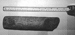
Figure 1. DkAm-1: Maritime Archaic celt/gouge.
Frequent visits and numerous test pits in the vicinity of the discovery unfortunately failed to reveal any further evidence of a Maritime Archaic presence in Little Grapes Cove. It is obvious, however, that the cove would have been an attractive location for a prehistoric site. Just below the site, a narrow cobbled beach gently slopes up into a wide and sheltered, albeit somewhat marshy, ravine [3]. Less than a kilometre into the ravine and away from the beach a small pond may have provided fresh water for the site’s occupants. Further still, approximately a kilometre and a half deeper into the ravine, a sandy precipice drops to water below on the other end of the peninsula’s neck. This cove is known locally as Big Grapes Cove. Investigations throughout this beautiful cove were also unsuccessful in locating any artifacts. Fishermen from Joe Batt’s Arm had informed me, however, that they once found clay pipes here. After personal inspection it seems reasonable to assume that erosion of the sandy cliff by storm action at its base could have contributed to the loss of historic and prehistoric material from the terrace above.
Geographically, the Little Grapes Cove and Big Grapes Cove area (see DkAm-2 also) is situated in a well sheltered ravine in the neck of a highly exposed peninsula. Maritime Archaic (DkAm-1) and Palaeoeskimo (DkAm-2) use of this area was certainly encouraged by the peninsula’s proximity to outer coastal resources. The peninsula is known today as a great spot for hunting harp seals in the spring, as the ice collects around the point or packs up just off shore. The peninsula is also the closest point on Fogo Island to the Little Fogo Island archipelago, where bird life is abundant. Without doubt, the occupants of both DkAm-1 and DkAm-2 would have been in an excellent position to procure outer coastal resources. To what degree resources were utilized remains in question. The paucity of maritime Archaic material recovered from DkAm-1 (i.e. one celt/gouge) suggests that use of the site and local resources by Maritime Archaic populations was likely less intensive than that practised by those who lived at the nearby Groswater site (see below).
DkAm-2: Newman Site
Just northwest of DkAm-1 is the site of DkAm-2. DkAm-2 extends across two grassy terraces which face into a garden. It is sheltered to the north and east by a small rocky ridge of exposed bedrock. The likely landing spot for small crafts approaching the site would have been via the narrow cobble beach of nearby Little Grapes Cove, the same beach presumably used by the occupants of DkAm-1. Palaeoeskimo material, stylistically similar to Groswater phase material, was recovered from the site along with historic material dating to the late 1700s and early 1800s. One ceramic fragment recovered from the site could date to the 1600s.
A substantial portion of the site is located on the larger of two grassy terraces which overlook Little Grapes Cove. The site also extends onto a small grassy terrace immediately below the larger one. The size of the two areas together compose a site area of approximately 40 x 70 metres. Historic ceramic material recovered from the site supports a late 19th century occupation. Other historic material also recovered from the site, and which dates to the late 1700s or early 1800s, presumably could have been family heirlooms, brought over from Europe.
In addition to the historic occupation of the site, DkAm-2 also revealed a Groswater phase, Palaeoeskimo period presence which was indicated by the recovery of 86 micro-flakes, two microblade fragments, one broken side blade tip, and a white rhyolite (?) core fragment. All artifact material was recovered from random test pit excavations on a featureless terrace. It was impossible to discern house pits or tent rings on the surface. More intensive excavations might reveal evidence of such structures, however, it is unlikely given the shallow depth of the soil. Rather, it is likely that structural features do not exist. Structural features simply may have never been present, or if they once were, they could have been removed from the area by visitors during the course of the historic occupation(s) of the site.
DkAm-2 was the most impressive site discovered during this year’s survey. The site does not appear to be disturbed, although with limited investigation it was difficult to ascertain what damage was done during the historic occupation(s) of the site. It seems likely that if disturbance occurred it was minimal. The most promising aspects of DkAm-2 are the relative wealth of archaeological material recovered from the site, when compared with prehistoric material from elsewhere on Fogo Island, and the site’s proximity to extreme outer-coastal resources. The site’s location just south of Fogo Island’s most northerly point no doubt facilitated access to harp seals in the spring, and possibly even in December, when populations passed close to shore (see Schwarz 1992). The site is also the closest point to the Little Fogo Island archipelago, a small cluster of islands just a few kilometres north of the site. Birds may have been available on these islands, and seals as well. DkAm-2 would also have been an ideal spot to observe ice conditions and monitor offshore resources. Finally, I talked to several people who have found whale bones in the site’s general vicinity and many more who have seen whales just off the coast here. In all, one would have a difficult time finding a more outer-coastal oriented site in Northeastern Newfoundland than the one located here, near Brooke’s Point, on the northern tip of Fogo Island. In this regard, the site’s importance to students interested in Groswater adaptations is obvious. Finally, DkAm-2 is likely the largest and last undisturbed prehistoric site on Fogo Island; it is worthy of preservation, and if initiated, careful study.
DkAm-3: Turpin’s Trail-1
The Turpin’s Trail site is perhaps the most perplexing of all the sites discovered during this year’s investigations. The site is located in a small clearing in the woods just west of the western end of Sandy Cove Beach. The site is immediately off Turpin’s Trail, a trail currently under construction by TRACS (Tilting Recreational and Cultural Society) (Dwyer 1995). The Trail’s name derives from Michael Turpin, a resident of Sandy Cove, who in 1809 was beheaded by the Beothuk on nearby Sandy Cove Beach, at a place now referred to as Turpin’s Rock (see Howley 1915:268; Kinsella 1994). At the site several ceramic sherds were recovered, one of which suggests an early to mid-18th century date. The piece in question is a Westerwald ceramic fragment, a type not known in Newfoundland after 1770. The piece is interesting given the context of the site in the forest and its distance – perhaps 300 metres – from the coast. The early date may indicate some of the earliest settlement in the area, perhaps by migratory French fishermen or early Irish residents. The name of the nearby town of Tilting apparently derives from the “tilts,” or flimsy cabins, in which the migratory fishermen of this early period lived. The site’s location away from the water and its location on uneven ground may suggest a temporary tilt-like structure.
Although further excavation is necessary, several areas in and around the site showed evidence of burning. It could be that the area between the tilt and the beach was once denuded of forest cover, the tilt perhaps erected at the edge of the forest for shelter or firewood. If the area between the site and the beach was clear, residents of the tilt would have had an excellent view of the surrounding landscape, the beach and the cove. Forest clearing could have been a consequence of shipbuilding operations, fish stage construction, or as a way of putting distance between the settlers on the coast and the Beothuk in the forest. Residents have told me stories they have heard about early settlers clearing land for this purpose, which is not surprising, given the recurring theme of fear which seems to have permeated settler attitudes toward the Beothuk on and around the Fogo Island area (see for example Bakker and Drapeau 1994; Howley 1915:27-28; Kinsella 1994; Marshall 1989:121).
In any case, the nature of settlement at DkAm-3 is problematic. Several ceramic pieces may also hint at a 19th century occupation. An older resident of Tilting with a long memory, told me that he had always known of the spot as “Keough’s place.” He never remembered anyone living there however, and the name probably refers to a long-forgotten occupant of the area (similarly, see Pocius 1991). Whether the Keoughs lived at DkAm-3 in the 1800s or in the 1700s is uncertain, as is the origin of the Westerwald piece.
Future excavation and historic research is definitely advocated for DkAm-3. The site’s proximity to Turpin’s Trail as well as its potential ties to Tilting’s earliest occupants, makes this site ideal for public interpretation and local history. Moreover, the Tilting Recreation and Cultural Society has informed me that they would be very supportive of such an endeavour.
DkAm-4: Seal Cove-1
Seal Cove is an abandoned community just north of Sandy Cove, in the general vicinity of Tilting. Remnants of the community can be spotted along the Cove’s edge and up on the large grassy hillside which flanks the Cove. The approximate distribution of community remains throughout this area is 400 m2. As with other abandoned communities, cellars, house foundations, and gardens are the most obvious signs of a historic presence. Archaeological investigations at this site only focused on the area closest to Sandy Cove. Future researchers are encouraged to explore the larger hillside as well.
Limited test-pitting unearthed pottery fragments stylistically similar to ceramics from the early 1800s; other pieces were more broadly designated as 19th century material. The site’s history is interesting in that it may represent early permanent settlement in the Sandy Cove area. As with Cape Cove (DjAm-1) the site also provides an archaeological context from which one could explore early outport community life. The site’s relatively undisturbed state would also facilitate future study.
DkAm-5: Tilting Harbour-1
In the town of Tilting, approximately 100 metres behind the historic Lane House, in a tiny cove, two grey-black flakes were recovered through test pit excavation. The find was made on a low-lying grassy terrace mere centimetres above a small sandy beach. Flotsam and jetsam lay scattered across the site, on the beach, and along the grassy banks of a nearby hill. The area appears to suffer from storm tidal action, and as a result, it is likely that the site has been obliterated by coastal erosion. Further test pits in the area revealed no new artifacts, and the flakes referred to above may be made of rhyolite, perhaps derived from Bloody Bay Cove Quarry in Bonavista Bay (see McLean 1994a, 1994b, 1997a, 1997b).
DkAm-6: Greene’s Point
This rather ambiguous site covers a rather large portion (400 m x 300 m) of Greene’s Point, a locally familiar arm of land which juts out toward Pigeon Island on the eastern end of Tilting Harbour. Archaeological investigations were initiated in this area on the recommendation of the TRACS committee, who were interested in identifying the location of a French garrison rumoured to have once been here. Although it is likely that some form of a “garrison” was here (a cannon survives) I was unable to identify where such a garrison may have been located. My explorations in an area I designated as Area A (the northwestern strip of coast bordering the harbour) and Area B (the stretch of land from the cannon to Greene’s point proper) unearthed only inconclusive artifacts; the artifacts in themselves do not suggest any site or feature integrity. A number of odd and chronologically incoherent pieces make up the assemblage: brick fragments, broken glass, various ceramic pieces dating anywhere from the late 1700s to the early 1900s, a dog(?) bone, and glass fragments from a Vicks or cod liver oil bottle make up the motley assemblage of artifacts.
It was disappointing not being able to locate the garrison that the community had hoped I would find. It seems unlikely, however, that the surviving cannons were ever within the walls of a well fortified garrison. Such a structure, if it existed, certainly would have been visible in the area’s shallow soil, or ingrained in local lore. Since fortified garrison evidence is non-existent, the cannons may have merely signified a military presence in the area, perhaps associated with wooden buildings or otherwise minimal fortification. Alternatively, the cannons may derive from a shipwreck or abandoned cargo. Scholarly research into the cannon’s place of origin, make, and model would likely provide some answers.
The artifacts I collected from test pits at the site are difficult to associate with individual features in space or in time periods in history. As a result, I do not believe that future excavation in this specific locality would be worthwhile. This is not to deny the historical significance of the harbour within the larger context of Fogo Island and Newfoundland history however; it merely appears as if too much of the archaeological record here has been disturbed and/or crammed into too little space. The “site” presents archaeologists with all the complexity of excavating an unstratified midden. Elucidating information from Greene’s Point would likely prove to be a daunting and largely uninformative exercise.
DkAm-7: The Head Site
The Head site is a true spot find site. I discovered this “site” while walking out toward the Head, a point of land near the town of Tilting, which extends out from Oliver’s Cove toward the North Atlantic. The site consists of only a core fragment, which was recovered from the surface of the trail on which I was walking. The core fragment is of a grey-white material similar to a piece found at DkAm-2, and is blocky and irregular. Further test-pitting around the find failed to locate any other cultural material. This did not surprise me given the location of the site on a rocky point of land with relatively little soil cover and few areas suitable for landing. Other than simply being lost, it is difficult to imagine how else the core could have ended up at this spot.
DkAm-8: Little Fogo Island-1
The Little Fogo Island site is located on an island locally known as “Little Fogo Island” (also Waterman’s Harbour Island) in the Little Fogo Island archipelago – a cluster of tiny barren islands just north of Brooke’s Point. Like the Cape Cove-Fogo Island site (DjAm-1), Little Fogo Island continues to be used on a periodic basis. With the cod moratorium currently in place, use of the island is primarily seasonal, for sealing in the spring or vacationing in the summer. Even as occupation is not permanent, there is still a persistent sense of community on the island, with a number of families making regular trips to the island (especially during the summer). These regulars often maintain cabins on the island, and through kin relations, social ties, or proximity, make up the Little Fogo Island community.
Test pits on Little Fogo Island concentrated on the “abandoned” community of Waterman’s Harbour, where many cabins, fishing stages, “stores” (sheds), and an old church (erected 1867) are located. Test pits in the vicinity of the community uncovered several ceramic fragments attributable to the 1800s. This corroborates with historical data which recognizes a population of 18 in 1857 (1857 Census). It is possible, however, that seasonal occupation of the island extends back much further. The island would have been an ideal location for ships to stop and collect birds or seals en route to Labrador or the French Shore. Prehistoric and historic visits by aboriginal on Newfoundland also cannot be ruled out. Unfortunately, investigations on nearby islands were prevented by engine problems on the boat in which we arrived, necessitating a direct return to Fogo Island.
The significance of the Little Fogo Island site is rooted in a number of rich “histories”: in a wealth of stories and memories pertaining to the place, in the preservation of fishing stages and stores, and in its occupants, who maintain strong personal and residential ties to the island. In many contexts, beyond those offered by archaeology, the island is an “historic” site. Further research by social scientists of any trade (historians, architects, anthropologists, archaeologists) is highly encouraged.
DkAn-1: Barr’d Islands-1
On the recommendation of a lobster fisherman I encountered in Shoal Bay, I visited a man from Barr’d Islands to inquire about some “Beothuk” artifacts he had apparently found some time ago. When I questioned him, he informed me that he had indeed once found a long bone piece (approximately 20 cm long), smooth and pointed on one side with a hole drilled in the end of the other. He had made the discovery some 30 or 40 years earlier and had given the piece to an uncle, now dead. He apparently came across the piece, wrapped in birch rind, in a pile of eroding bedrock behind his house. At the time, he was excavating the pile for construction fill. The spot he led me to was an extremely rocky area of eroding bedrock above a small cove just east of the eastern arm of Barr’d Islands. The spot is wholly unsuitable for settlement, and thus it is likely that the bone point – given its context in the stone pile and birch bark “sheath” – was associated with a Beothuk burial. Nearby sites slightly more attractive for settlement were currently occupied by gardens and encircled by fences and were unable to be investigated.
I excavated deeper into the rockpile where he had found the point 40 years earlier, but to no avail. The eroding bedrock pool in which the artifact was found, as well as other nearby bedrock piles, were all filled with murky water, making recovery of cultural material difficult. Furthermore, given the context of the find, it seemed unlikely that any more material would be recovered. Before leaving I examined several other eroding bedrock piles in the site’s general vicinity.
The bone point the man described could have been a Beothuk harpoon point with the drilled end enabling attachment to a foreshaft. Alternatively, the point may have been a stylized Beothuk bone pendant (Pastore, personal communication). The artifact’s association within a possible burial context would tend to make the pendant interpretation more likely. In any case, this invisible artifact is all Fogo Island offered this year in terms of material evidence for Beothuk occupation.
DkAn-2: The Esso Site
The exact location of this site is still in question. However, based on discussions with the individuals involved in the discovery of a Maritime Archaic gouge (see Figure 2), one particular residence seems to be the most probable origin of the artifact. The house borders the western edge of Seal Cove just outside the town of Fogo. It is situated on a level grassy terrace, adjacent to a small freshwater stream and just above a narrow cobble beach. In many ways the house’s location fits the ideal characteristics of a prehistoric site (see Pastore 1981). Unfortunately, several houses now cover the terrace, a road runs between them, a dock borders the beach, and two large Esso gas tanks obliterate everything else. The owners of the house were kind enough to allow test pits on their property, perhaps at the last surviving remnants of the site. Unfortunately excavations in this area did not unearth any prehistoric cultural material. I was unable to investigate other properties in the area, although I doubt that much cultural material would be recovered from these disturbed contexts.
The history of the Maritime Archaic gouge is rather complicated. The gouge was initially discovered by a man beneath his old house in Fogo. He believes, however, that the original context of the artifact can be traced to construction fill he obtained from another house. Accordingly, it is difficult to pinpoint exactly where the artifact came from. I did not test-pit inside the man’s property (the alternative origin of the artifact), although I managed to test-pit around the perimeter – no material was recovered. Feasibly, both his property (deep in Fogo Harbour) and the Seal Cove property would have been attractive locations for settlement. However, as both have suffered from extensive destruction by construction it seems unlikely that the true origin of the artifact will never be known. At this point it seems reasonable to assume that the informant’s assessment of the original context of the artifact is accurate, and that the gouge derives from the area of the Seal Cove residence.

Figure 2. DkAn-2 (The Esso Site): Maritime Archaic Gouge.
DkAn-3: The Dump Site
A large biface was also discovered in construction by another resident of Fogo. This man was less certain of the context of the biface however, and was unsure as to whether the biface originated at the source of the fill or at the location of the discovery itself. He uncovered the biface while doing construction work at the old United School house, located near the entrance to the town of Fogo. The fill used for the project was obtained just up the road at a quarry on the southeastern corner of Seal Cove. After visually inspecting and test-pitting both locations (to no avail), my guess is that the biface originated from the quarry area (i.e. a product of the fill). The area in which the United School is located is several hundred metres away from any water and at the base of a rocky cliff. In contrast, the quarry is adjacent to a wide cobble beach and nearby freshwater stream. Unfortunately the quarry has caused widespread destruction in the area just up from the beach, while the beach itself has been used as a dump for quite some time. Test-pitting here was utterly fruitless: mounds of trash lay buried just beneath the surface, covering every possible attractive stretch along the water. The site, if there was one, is irrevocably destroyed.
The only known remnant from the site is the biface this man showed me (Figure 3). The biface is rather large, measuring 13 cm long by 5 cm wide. It is made of a light grey material with white banding running east-west across the blade. The proximal stem-like portion of the blade appears to have broken off. One side of the biface appears to be more convex than the other. I suspect that the piece is Maritime Archaic.
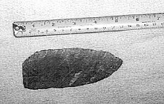
Figure 3. DkAn-3 (Dump Site): Biface (Maritime Archaic?).
DkAn-4: Dump Quarry Site
In a small cove just south of the Dump Site (DkAn-3) in Seal Cove, my wife found evidence of flaking activity in a small rock overhang near the beach. A narrow cobble beach climbs up to a small cave/shelter formed by large exposed bedrock slabs jutting out of the hillside. All along the front entrance of the overhang evidence of bedrock “battering” is apparent, and below and in the cave, some crude primary flakes were recovered. It appears that the bedrock area was used as an expedient quarry only a few times. Nowhere was extensive quarrying evidence apparent either on the shelter floor or on the bedrock itself. Although storm action appears to reach the cave’s entrance, it is unlikely that coastal erosion would have eliminated evidence of intensive lithic procurement. Moreover, the dark grey or blackish rhyolite-like (?) matrix of the bedrock does not appear to offer ideal raw material for stone tool production. Lithic procurement strategies at the site seem expedient-based and the bedrock matrix rarely utilized. Although the biface recovered from DkAn-2 is not of the same matrix, it seems reasonable to assume that the occupants (Maritime Archaic?) of the nearby dump may have used the nearby “quarry” for expedient-tool raw material.
Conclusion
Interpretation
It is difficult to deduce patterns of behaviour for Fogo Island merely from survey data. It appears however that settlement of Fogo Island was non-intensive and sporadic. Despite historical records suggesting high Beothuk visibility in the area, the archaeological record is less clear in regards to the nature of Beothuk activity [4]. Subsistence-wise, the Fogo Island arena appears to have been used primarily for birding activities or for other pursuits which would have encouraged non-intensive settlement. In addition, it is likely that settlement by the Beothuk, and perhaps by Maritime Archaic populations as well, was warm weather oriented. Settlement along sandy beaches, such as in Sandy Cove, might have been temporary in nature and its remains subject to coastal erosion during the winter months. There is little evidence for pit houses or other labour intensive type settlements which one would expect in cold weather or long term occupation of the island. This is not to deny the use of Fogo Island during the winter months by Indian populations (i.e. the proximity of the Maritime Archaic Site DkAm-1 to seal populations), however utilization at this time was likely temporary and resource specific, with base camps located deeper inland on the “mainland.”
In contrast to the Indian occupation, the relatively large Groswater site discovered this summer (DkAm-2) may suggest a more cold weather occupation. This would support a model of settlement variability between different island populations as put forth by Pastore (1986), Schwarz (1992, 1994), and Holly (1997). Although evidence of substantial structures was absent at the Groswater site, this may be a result of historical destruction. Alternatively, structures at the site could still be discovered or be represented differently (i.e. in post holes rather than stones). In any case, site use at the Groswater site was definitively more intensive than anything recognized at other sites on the island.
Undoubtedly many of the sites discovered this year can be classified as spot finds i.e. flake scatters and find sites. The non-visibility of such sites can be attributed to generally non-intensive use of the island, and perhaps, by destruction of sites during the historic period. Although I suspect that European settlement, gardening activities, and construction, were disastrous to the preservation of archaeological sites on the island, I do not feel that such activities would have masked a significant settlement occupation of the island. Two months of living on the island, surveying, and seeking information pertaining to artifacts and areas of historic relevance, enabled me to get a high resolution picture of the archaeological record of the island. If island use was intensive prehistorically, one would expect to see some sort of indication of this represented archaeologically in private collections. I am assured that large collections of archaeological material do not exist on the island. From my experience on this closely knit island, community members would know if other residents had artifactual evidence. In fact, I spent a fair amount of time tracking down false leads or individuals that had only one piece. Presumably if prehistoric settlement was intensive or of long duration, this would be reflected archaeologically in large and numerous private collections.
In summary, it appears that for the most part island use was sporadic and of low intensity (particularly during the early and later Indian periods). My guess is that prehistoric island use was oriented primarily toward specialized birding activities and seal procurement. Use of the island by the Beothuk during the historic period may have focused on iron procurement and harassment campaigns against settlers. Subsistence activities by the Beothuk in the historic era may have concentrated on bird populations around nearby islands such as the Wadham and Little Fogo Islands. Finally, investigations around cape Fogo and the rest of the island do not support the theory that Fogo Island was a jumping off point for Funk Island. The area along these coasts, particularly around Cape Fogo, is entirely rocky and unsuitable for camps oriented toward long range expeditions. It now seems likely that the Beothuk departed from the strait on the mainland, perhaps using Cape Freels as a gathering/departure/arrival point for these treacherous expeditions.
Notes:
1. Government of Newfoundland and Labrador Permit 97.7
2. In order to avoid the confusion which, in this case results from standard English usage, in this paper the capitalized Island, when used by itself, will refer to the Island of Newfoundland, while the lower case island, used by itself will refer to Fogo Island or any other small island implied by the context. – Editor’s note.
3. The area was quite marshy. It is possible, however, that drainage was different at the time of the Maritime Archaic occupation.
4. If the bone “point” discovered by one informant can be associated with a burial, then the only material evidence we have for the Beothuk on Fogo Island is burial-related (see also Anonymous 1887a, 1887b).
Works Cited
Anonymous
1887a – “Remains of the Red Man Discovered.” Evening Mercury, 1 November.
1887b – “Discovery of the Red Indian Remains at Fogo.” Evening Mercury, 2 November.
Bakker, P. and L. Drapeau
1994- “Adventures with the Beothuks in 1787: A Testimony from Jean Conan’s Autobiography,” in Actes du Vingt-Cinquième Congrès des Algonquinistes, W. Cowan, ed., pp. 32-45. Carleton University Press, Ottawa.
Cobb, B.
1997 – “Archaeologist Explores Fogo Island.” Fogo Island Flyer, July 1997:6.
Dwyer, R.
1995 – “TRACS Report: Turpin’s Trail and Keefe’s Stage.” The Tilting Expatriate 3:3.
Holly, D.
1997 – “Revisiting Marginality: Settlement Patterns on the Island of Newfoundland.” Unpublished A.M. Thesis, Brown University, Providence, R.I.
Howley, J.P.
1915 – The Beothuks or Red Indians. Cambridge University Press, Cambridge.
Kinsella, J.
1994 – “Fogo Island The Red Indian Connection.” The Tilting Expatriate 2:6-11.
Lysaght, A.M.
1971 – Joseph Banks in Newfoundland and Labrador. University of California Press, Berkeley.
McLean, L.
1990 – “A 1989 Report on Archaeological Survey in Bonavista Bay.” Unpublished manuscript on file at the Newfoundland Museum, St. John’s.
1991 – “Burnside Heritage Project: Archaeology Report for Summer, 1990.” Unpublished manuscript on file at Historic Resources, Government of Newfoundland and Labrador, St. John’s.
1994a – “Burnside Heritage Project: 1992 Archaeological Report.” Unpublished manuscript on file at Historic Resources, Government of Newfoundland and Labrador, St. John’s.
1994b – “Burnside Heritage Foundation, Inc: 1993 Archaeological Report.” Unpublished manuscript on file at Historic Resources, Government of Newfoundland and Labrador, St. John’s.
1997a – “Burnside Heritage Foundation 1996 Activity Report.” Unpublished manuscript on file at Historic Resources, Government of Newfoundland and Labrador, St. John’s.
1997b – “Burnside Heritage Foundation, Inc. 1994 Archaeology Report.” Unpublished manuscript on file at Historic Resources, Government of Newfoundland and Labrador, St. John’s.
Marshall, I.
1989 – Reports and Letters by George Christopher Pulling, Relating to the Beothuk Indians of Newfoundland. Breakwater Books, St. John’s.
1994 – “Report on Archaeology Survey of Eastern Indian Island and Visit of Beothuk Grave on Phillips Island, 24 to 26 June, 1994.” Unpublished manuscript on file at Historic Resources, Government of Newfoundland and Labrador, St. John’s.
1996 – A History and Ethnography of the Beothuk. McGill-Queen’s University Press, Montreal.
Pastore, R.T.
1986 – “The Spatial Distribution of Late Palaeo-Eskimo Sites on the Island of Newfoundland,” in Palaeo-Eskimo Cultures in Newfoundland, Labrador and Ungava, pp. 125-134. Reports in Archaeology no. 1, Memorial University of Newfoundland, St. John’s.
Penney, G.
1988a – “Historic Resources Overview Assessment of the Proposed Change Islands-Fogo Island Provincial Electric Grid Interconnection.” Unpublished manuscript on file at Historic Resources, Government of Newfoundland and Labrador, St. John’s.
1988b – “An Archaeological Survey of Western Notre Dame Bay and Green Bay.” Unpublished manuscript on file at Historic Resources, Government of Newfoundland and Labrador, St. John’s.
Pocius, G.
1991 – A Place to Belong: Community Order and Everyday Space in Calvert, Newfoundland. University of Georgia Press, Athens.
Reader, D.
1996 – “Archaeological Investigations along the North Shore of the Bay of Islands, Newfoundland, 1995.” Unpublished manuscript on file at Historic Resources, Government of Newfoundland and Labrador, St. John’s.
Schwarz, F.
1992 – “Archaeological Investigations in the Newfoundland Interior.” Unpublished manuscript on file at Historic Resources, Government of Newfoundland and Labrador, St. John’s.
1994 – “PaleoEskimo and Recent Indian Subsistence and Settlement Patterns on the Island of Newfoundland.” Northeastern Anthropology 47:55-70.
Thomson, C.
1981 – “The Beothuk Project: A Survey of Notre Dame Bay including Comfort Cove, Rattling Brook, Charles’ Brook around the Bay of Exploits, Fogo I., Indian Is., Change Is., & Badger Bay.” Unpublished manuscript on file at Historic Resources, Government of Newfoundland and Labrador, St. John’s.
Whiffen, G.
“Fogo Island’s historical treasures yet to be found.” The Evening Telegram, July 24, 1997.