

The Main River provides a true wilderness experience for capable outdoor enthusiasts. This means that if you want to visit, you must be prepared both to enjoy an unforgettable time, and to be self-sufficient while doing it.
Outdoor activities perfect for the Main River area include the following:
- Canoeing/Kayaking/Rafting
- Angling
- Hunting
- Wilderness Camping
- Hiking
- Swimming
- Bird and Wildlife Watching
- Snowmobiling & Winter Recreation
Once you’re on the river, the only “outside world” communications option is a satellite phone. Woods roads exist in the area, but exit trails from the river to access them are few, and rough. There are no buildings or services along the river. Visitors are asked to leave no trace of their passage, and are encouraged to engage local guides and adventure tourism services.
The white-water sections of the river run from Class 1 to Class 3 levels of difficulty, and portage trails are very rough. Packing wet-weather gear, insect repellent, and sunscreen is advisable. But the benefits are an unparalleled experience of nature and a memorable river ride.
The Main River area can be enjoyed year-round; the canoeing/kayaking season is late May to late June.

Canoeing/Kayaking/Rafting
In its entirety, the Main River is 57 km long and drops 675 metres to sea level. It runs from the headwaters in the Long Range Mountains, southeastward to Sop’s Arm and White Bay. Its rapids run from Class 1 to Class 3 difficulty. It also experiences major water-level fluctuations after heavy rains-up to two metres in 24 hours-which visitors should take into account before setting out and before pitching a tent.
The river has five distinct sections in its run to the sea (view map)
Four Ponds Unit
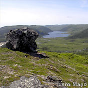
About 6.5 km in length, this section traverses the four ponds at the headwaters. The topography in the area varies from rolling forested hills to sparsely vegetated open barrens.
Upper River Unit
Extending 10 km from the lowest of the four ponds in the headwaters section, this section leads to the Big Steady. The landscape features mature balsam trees, rolling to steep river banks, and a 6-km boulder garden just before the top of the Steady.
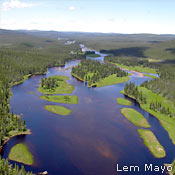
Big Steady Unit
An 8-km flat and winding stretch through a unique and wildlife-rich grassland area, the Big Steady is an enriched floodplain of great beauty and serenity. It takes in about 15 km2.
Rapid River Unit
This 8-km rapid-descent stretch has a gradient of 7 metres per kilometre and a Class-3 difficulty rating. Canoeists are treated to the unusual view of a gradient so steep that visibility down the reach is restricted. A narrow rock ledge offers a magnificent view of a waterfall cascading into the river from the North Brook on the right bank.
Deep Valley Unit
25 km of white water (Class 1 through 3 difficulty levels) passing through a steep-sided rocky canyon, and ending in the delta near Sop’s Arm. Commercial rafting operations generally run on the last 23 km of the river in early June. For a list of operators, see services.
The best season for paddling the river is late May to the last week in June. Paddling the entire river length is a four- to five-day adventure, unless you choose to linger and explore. For example, a major inlet leads away from Paradise Pool into a series of pools and bays that are hidden from the main part of the Main.
Canoeing the entire river can involve several portages, depending on water levels and individual skill levels. The following information should help you determine if you are ready.
Water level and its effects
The Department of Fisheries, Forestry and Agriculture maintains a water-flow meter in the Big Steady. (See the Main River listing under the “Central and North” heading.) Canoeists are strongly advised to check the meter before embarking on a canoe or kayak trip on the Main River.
A flow rate of less than 25m3 per second normally means you will spend several hours dragging or lining your canoe around boulders and over falls. An area of particular concern at such times is the 6-km boulder garden in the Upper River Unit.
The Deep Valley Unit is good for canoeing when the water level is around 20m3 per second. Outside these levels, it is too dangerous for even the most skilled canoe/kayak enthusiasts. Please check with local guides and outfitters (see services) for advice on ideal canoeing water levels.
Important note: Only very skilled canoe/kayak enthusiasts should attempt passage through the Deep Valley Unit. Rescue from this deep canyon, even by helicopter, is extremely difficult.
See a map of the river sections, access routes, and portage locations.
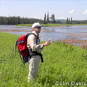
Angling
Atlantic salmon use almost the entire Main River system-unlike most rivers, there are no natural barriers to prevent them from entering the upper headwaters and most tributaries.
The Main River is a Class II scheduled salmon river. The salmon season usually runs from June to September; check the most recent Anglers Guide (produced annually by Fisheries and Oceans Canada) for this year’s dates. Only fish measuring 63 cm or less-from the tip of the nose to the fork of the tail-may be kept.
Anglers find the best spots to fish in the Big Steady and lower reaches of the river. Several outfitting camps are located near the Heritage River, offering salmon fishing to non-residents and local fisherpersons.
Residents must hold a valid salmon licence. Licences are available at many local sport shops and convenience stores.
Important Note: Non-residents of the province require a licence to fish in any inland waters; they must also be accompanied by a licensed guide when fishing for salmon. Non-resident licences are available from local sport shops and convenience stores.
For a list of licenced guides, visit the Government of Newfoundland and Labrador Hunting and Fishing Site.
All provincial and federal regulations apply when fishing in the Canadian Heritage Rivers.
Hunting
If you hold all proper licences and follow all federal and provincial regulations, you may hunt moose, caribou, black bear, ducks, and geese in the Main River Canadian Heritage River area during their open seasons. Several outfitting camps located in the area cater to big game hunters.
No trapping or snaring of small game or fur-bearers is allowed in the Main River, however. This restriction is in place to protect the endangered Newfoundland marten. Contact Inland Fish and Wildlife Division for trapping regulations outside the Heritage River area.
Wilderness Camping
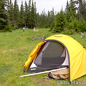
As a wilderness area, the Main River requires its visitors to “leave only footprints.” For guidelines on how to do this, see Rules & Regulations. Except for at its mouth, there are no services along the length of the Main River.
Good wilderness camping locations exist at a few locations (See map). There are currently no picnic tables or outhouses (they may be added in the future). The one exception is the camping site at Paradise Pool, where there are two picnic tables and an outhouse on a grassy meadow. The map indicates good tenting spots-areas that are relatively dry, have grassy ground with few pebbles or stones, and catch the breezes that help keep mosquitoes at bay.
The good camping locations include:
- the lower two ponds in the Four Ponds Unit
- two locations in the Upper River Unit
- two sites in the Big Steady Unit (at the top of the Steady and Paradise Pool)
- Sunshine Falls/Corner Pool
- Sop’s Arm Park, at the mouth of the river in Sop’s Arm. This 10-hectare park has 25 sites for tents or trailers, and is staffed from mid-June to early September.
Important Caution: When choosing a campsite, remember that in wet conditions the Main River can rise up to 2 metres in 24 hours. It is important to set up camp where you will not be vulnerable to quick-rising river levels. See the Canoeing section for guidelines on how to check water levels before you go. Keep an eye on the weather when in the area.
Hiking
The best hiking in the Main River occurs in August. The Big Steady Unit provides excellent hiking opportunities when water levels are low (that is, when the flow rate is less than 7 m3 per second). At these times it is easy to use the moose and caribou trails that traverse the islands and follow the Main.
Outside this time and area, hiking is difficult. There are currently no maintained hiking trails in the area.
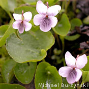
Swimming
The pristine, cold waters of the Main River provide refreshing swimming. At the lower ends of some of the ponds, there are even sandy beaches. The riverbanks are generally rocky. Please pay close attention to safety while swimming-no safety equipment or lifeguards exist anywhere on the River.
Bird and Wildlife Watching
Binoculars are an excellent addition to the pack when travelling on the Main River.
Commonly occurring waterfowl include Canada geese, several species of duck (black, green- and blue-winged teal, red-breasted merganser, common goldeneye), and osprey. Bald eagles and greater yellowlegs are often spotted near the river. In the barrens area you may see rough-legged hawk, savannah sparrow, rock ptarmigan, or snowy owl; in the wetland areas you’ll find northern harrier, short-eared owl, and swamp and Lincoln’s sparrow.
On the barrens you may also encounter caribou or coyote; in the forests are moose, black bear, beaver, mink, and lynx. The old-growth forests along the Main River provide habitat for the endangered (and notoriously curious) Newfoundland marten, and there are otter in the river.
Snowmobiling & Winter Recreation
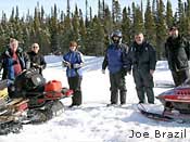
In the Main River, snow conditions appropriate for snowmobiling and winter camping persist for much longer than elsewhere on the Island-often from January right through to May.
A snowmobile trail heading west from Sop’s Arm leads to Four Ponds, with diversions along six of the river’s tributaries.
Several outfitters offer expeditions to the River in the winter months (see Services).
Adobe® Acrobat® Reader software can be used for viewing PDF documents. Download Acrobat® Reader for free.