

Milestones
WRMD Climate Stations
NL Climate Network Owners Working Group
Real Time Climate Data
Historical Climate Data
Reports and Publications
Related Links
Contact Information
Milestones
Some important milestones in weather and climate monitoring in Newfoundland and Labrador include:
1775 ‒ Newfoundland Hurricane is the first recorded hurricane to hit Atlantic Canada and caused considerable death and destruction in the then colony of Newfoundland.
1871 ‒ Earliest recorded climate data for Newfoundland and Labrador available from Environment and Climate Change Canada for St. John’s and Point Amour (lighthouse).
1986 ‒ Newfoundland and Labrador and the federal government sign an agreement regarding climate stations and programs in the province.
1995 ‒ The first automatic climate station is installed in the province.
2010 ‒ Hurricane Igor hits Newfoundland and is the most destructive hurricane on record to ever hit the Island with damages amounting to $200 million.
2018 ‒ The NL Climate Network Owners Working Group is formed.
WRMD Climate Stations
Climate stations can measure a variety of parameters using different combinations of instrumentation. WRMD currently has thirteen (13) active automatic climate stations.
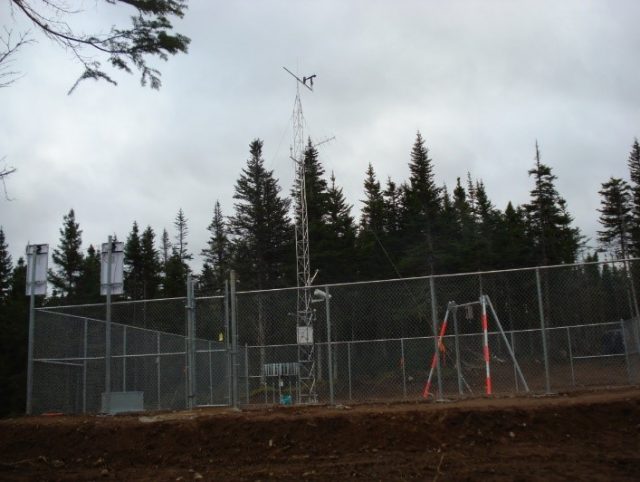
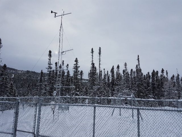
NLENCL0005 – Sandy Lake at Birchy Narrows NLENCL0007 – Upper Humber Above Black Brook
These climate stations include a combination of the following parameters:
| Parameters Measured | Description | Photo |
| Precipitation- Tipping Bucket (PTB) | The tipping bucket collects precipitation into a bucket mechanism that tips when it reaches a calibrated level. A magnet attached to the tipping mechanism activates a switch as the bucket tips. The datalogger counts the momentary switch closure. | 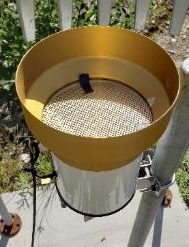 |
| Precipitation- Weighing Gauge (PWG) | The weighing gauge measures the weight of the precipitation as a function of time. This function is then converted to a precipitation depth. | 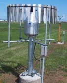 |
| Air Temperature (AT) | Air temperature is measured by a probe using a platinum resistive thermometer. | 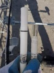 |
| Relative Humidity (RH) | Relative humidity is measured by a probe using a capacitive polymer H chip. | |
| Dew Point Temperature (DPT) | The dew point temperature is measured using the air temperature and relative humidity sensor. The datalogger first calculates the saturation vapour pressure, and uses that to calculate the measured vapour pressure. The dew point temperature is calculated using the measured vapour pressure. | |
| Humidex (HX) | The humidex is calculated using the measured air temperature and dew point temperature. | |
| Atmospheric Pressure (AP) | The barometric pressure sensor measure the changes in the pressure exerted by the atmosphere. | 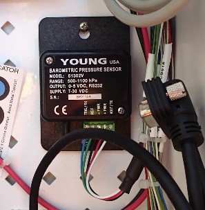 |
| Snow Depth (SD) | The snow depth sensor measures the depth of the snow by emitting an ultrasonic pulse, and measuring the elapsed time between the emission and return of the pulse. An air temperature measurement is needed to calculate the speed of sound in air. | 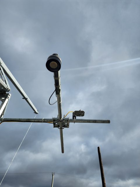 |
| Snow Water Equivalent (SWE) | Snow water equivalency is measured by passively measuring the change in naturally occurring electromagnetic energy from the ground after passing through the snow cover. | 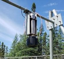 |
| Soil Moisture (SM) | Soil moisture is measured using a sensor that measures soil moisture in units of water fraction by volume (wfv or m3m-3) based on the real dielectric permittivity of electromagnetic radio waves (50 MHz) reflected in the soil. | 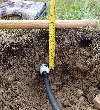 |
| Accumulated Incoming Solar Radiation (SR) | Solar radiation is measured using a pyranometer with a thermopile detector. It uses a series of thermoelectric junctions to provide a signal of several µV/W/m2 proportional to the temperature difference between a black absorbing surface and a reference. | 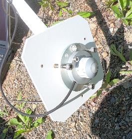 |
| Sunshine Hours (SH) | Sunshine hours are measured using the solar radiation sensor. Sunshine hours are defined as the time which the direct solar radiation exceeds the level of 120 W/m2. | |
| Wind Speed (WS) | Wind speed is measured by the anemometer. The rotation of its four-bladed, helicoid-shaped propeller produces an ac sine wave that has a frequency directly proportional to wind speed. | 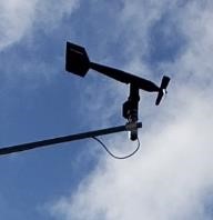 |
| Wind Direction (WD) | Wind direction is also measured by the anemometer. It is measured by the orientation of the fuselage-shaped sensor body. This is connected to an internal potentiometer. | |
| Wind Gust Speed (WGS) | Wind gust speed is measured in the same way as the wind speed. To get the wind gust speed, a shorter period of time is considered. | |
| Wind Gust Direction (WGD) | Wind gust direction is measured in the same way as the wind direction. | |
| Wind Chill (WC) | Wind Chill is calculated using the measured wind speed and air temperature. |
NL Climate Network Owners Working Group
In 2018, the province initiated the NL Climate Network Owners Working Group. The purpose of this group is to provide a forum for discussion amongst climate network owners in Newfoundland and Labrador, to share knowledge on the operation and maintenance of climate stations, to act as a resource on issues relating to climate monitoring, and to advocate for improved climate monitoring.
Climate network owners, operators and members of the Working Group include:
| Department of Environment and Climate Change (Water Resources Management Division) |
| Department of Fisheries, Forestry and Agriculture |
| Department of Transportation and Infrastructure |
| Environment and Climate Change Canada |
| Nalcor |
| IOC |
| Vale |
| SmartAtlantic |
| Wood |
| Queen’s University |
| Parks Canada |
This page links to information about meteorological networks maintained by network owners that are part of the Working Group. Where possible, we have provided links for data users on where they can find climate monitoring data.
A major part of the work of the NL Climate Network Owners Working Group is to identify and track the network of climate monitoring stations currently active in the province. To help provide a better understanding of network coverage throughout the province, stations belonging to different climate network owners are identified in the following map.
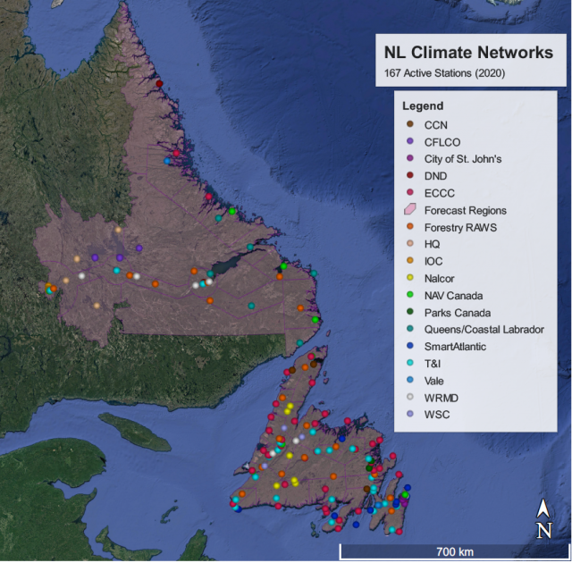
Efforts are made to keep this list current, and some stations operated by agencies that are not a part of the Working Group are also included. Data users are encouraged to communicate directly with local agencies to gain access to any additional local data where not publically available.
Real Time Climate Data
Links to real time climate station data:
- WRMD real time climate station data
- Forestry Branch real time climate station data
- Coastal Labrador Climate and Weather Monitoring Program stations
- SmartAtlantic and Coastal Labrador Climate and Weather Monitoring Program stations
- CIOOS Atlantic
- Environment and Climate Change Canada
- CoCoRaHS
Historical Climate Data
WRMD Real Time Climate Stations:
| Data are provided as either Quality Assessed (Qa) or Quality Corrected (Qc). Qa data have undergone automated checks and may contain flagged or unverified values, while Qc data have been further reviewed and corrected. For most purposes, users are encouraged to use Qc data.
1 Raw data up to December 31, 2025; 2 Quality assured (Qa) flagged data up to December 31, 2024; 3 Quality controlled (Qc) data up to December 31,2025. 4Vale LH1 MET – NLENCL0012 not operational in 2023-2025. 5Churchill River at end of Mud Lake Road- NLENCL004 not operational after June 27, 2023. |
||||||
| Station Name | Station Number | Date Installed | Raw Data1 | Qa Data2 | Qc Data3 | Metadata File |
| Pippy Park in St. Johns | NLENCL0001 | 10/13/2008 | Data file | Pre-2020; Post-2020 | Pre-2020; Post-2020 | Metadata File |
| Exploits River at Badger East of Stadium | NLENCL0002 | 9/16/2006 | Data file | Data file | Data file | |
| Humber River at Humber Village Bridge | NLENCL0003 | 9/3/2009 | Data file | Data file | Data file | |
| Churchill River at end of Mud Lake Road | NLENCL0004 | 7/8/2010 | Data file5 | Data file5 | Data file5 | |
| Sandy Lake near Birchy Narrows (Camp 55) | NLENCL0005 | 11/17/2010 | Data file | Data file | Data file | |
| Muskrat Falls MET | NLENCL0006 | 7/19/2014 | Data file | Data file | Data file | |
| Upper Humber River Above Black Brook | NLENCL0007 | 9/29/2015 | Data file | Data file | Data file | |
| TLH between Churchill Falls and Lab City (Ranger Lake) | NLENCL0008 | 10/20/2017 | Data file | Data file | Data file | |
| Metchin River near TLH | NLENCL0009 | 10/19/2017 | Data file | Data file | Data file | |
| Exploits Below Noel Paul’s Brook MET | NLENCL0010 | 11/25/2020 | Data file | Data file | Data file | |
| Mud Lake Road MET | NLENCL0011 | 10/8/2020 | Data file | Data file | Data file | |
| Vale LH1 MET | NLENCL0012 | 12/1/2020 | Data file4 | Data file4 | Data file4 | |
| Vale LH2 MET | NLENCL0013 | 2/17/2023 | Data File | Data file | Data file | |
| Marathon Gold MET | NLENCL0014 | 6/7/2023 | Data File | Data file | Data file | |
| Conception Bay South MET | NLENCL0015 | 11/1/2024 | Data file | Data file | Data file | |
Hydrometric Related Climate Stations (WSC):
| *Raw data file- no QA/QC; Discontinued Stations (in grey) | |||||
| Station Name | Station Number | Date Installed | Date Decommissioned | Data File* | Metadata File |
| Grand Lake East Of Grand Lake Brook | 02YK010 | 4/3/2006 | 11/9/2022 | Pre-2006; Post-2006 | Metadata File |
| Indian Brook Diversion Above Birchy Lake | 02YM004 | 1/1/1991 | 8/12/2021 | Pre-2006; Post-2006 | |
| Upper Humber River Above Black Brook | 02YL008 | 1/1/1991 | 12/31/2019 | Pre-2006; Post-2006 | |
| Granite Lake At East End | 02ZC004 | 4/3/2006 | 12/31/2019 | Pre-2006; Post-2006 | |
| Corner Brook Lake At Lake Outlet | 02YL009 | 1/1/1991 | 12/31/2019 | Pre-2006; Post-2006 | |
| Grey River Near Grey River | 02ZD002 | 4/3/2006 | 12/31/2019 | Pre-2006; Post-2006 | |
| Exploits River Below Noel Pauls Brook | 02YO011 | 2/14/2006 | 4/7/2019 | Pre-2006; Post-2006 | |
| Adies Lake | ADIES | 8/5/1996 | 5/16/2018 | Pre-2006; Post-2006 | |
| Burgeo Road near Buchans Access | BURGEO_RD | 11/26/1990 | 6/12/2018 | Pre-2006; Post-2006 | |
| Grand Lake on Glover Island | GRAND_LK_G | 11/26/1990 | 5/18/2018 | Pre-2006; Post-2006 | |
| Hinds Lake | HINDS | 8/25/1996 | 5/28/2018 | Pre-2006; Post-2006 | |
| Howley Road | SANDY | 3/20/1991 | 5/31/2018 | Pre-2006; Post-2006 | |
Hydrometric Related Climate Stations (WRMD):
| *Raw data file- no QA/QC; Discontinued Stations (in grey) | ||||
| Station Name | Date Installed | Date Decommissioned | Data File* | Metadata File |
| Bunyans Cove Brook (Bunyans Cove) | 8/13/1990 | 12/31/1994 | Data File | Metadata File |
| Cape St. Marys Brook (St. Brides) | 6/1/1991 | 12/31/1994 | ||
| Carters Pond Brook (Newtown) | 1/1/1980 | 11/30/1984 | ||
| Glendon Brook (Creston North) | 10/1/1987 | 12/31/1994 | ||
| Gully Brook (New Harbour) | 10/1/1988 | 12/31/1994 | ||
| Newmans Cove Brook (Newmans Cove) | 7/4/1990 | 12/31/1994 | ||
| Quarry River – Merrymeeting Pond (Ferryland) | 6/19/1991 | 12/31/1994 | ||
| Riverhead River (Riverhead) | 11/21/1988 | 12/31/1994 | ||
| Second Rattle Brook (Gander Bay South) | 9/26/1991 | 12/31/1994 | ||
| Square Pond Brook (Square Pond, Terra Nova National Park) | 1/1/1981 | 2/17/1987 | ||
| Steering Pond Brook (Grand Beach) | 1/1/1979 | 12/31/1994 | ||
| Terrence Pond Brook (Hearts Desire) | 1/1/1980 | 12/31/1987 | ||
| Trussel Brook (North Harbour) | 9/1/1987 | 12/31/1994 | ||
| White Lake Pond Brook (Corner Brook Lake) | 7/1/1986 | 12/31/1994 | ||
| Winterland Brook (Winterland) | 9/20/1990 | 12/31/1994 | ||
Data Key:
| Heading | Explanation | Units |
| AIR_TEMP | Air temperature | °C |
| AIR_TEMP_SCND | Secondary Air Temperature | °C |
| ATMOS_PRES | Atmospheric Pressure | kPa |
| BATT_VOLTAGE | Battery Voltage | V |
| DEW_POINT | Dew Point Temperature | °C |
| FLOW | Streamflow | m3/s |
| HUMIDEX | Humidex | °C |
| NST_DATI | Date and Time (NST Time Zone) | N/A |
| PRECIP_TB | Tipping Bucket Gauge Precipitation | mm |
| RAD_SOLAR | Accumulated Incoming Solar Radiation | kj/m2 |
| RAIN | Rainfall | mm |
| REL_HUMIDITY | Relative Humidity | % |
| SNOW | Snowfall | mm |
| SNOW_DEPTH | Snow Depth | m |
| SNOW_DEPTH_NEW | Snow Depth (new snowfall) | cm |
| SOIL_MOIS | Soil Moisture | % |
| STAGE | Water level elevation or stage | m |
| STAT_NUM | Station Number | N/A |
| SUNSHINE_HRS | Sunshine Hours | Decimal Hours |
| SWE_K | Snow Water Equivalent (K) | mm |
| SWE_TL | Snow Water Equivalent (TL) | mm |
| WATER_TEMP | Water Temperature | °C |
| WIND_CHILL | Wind Chill | °C |
| WIND_DIR | Wind Direction | Degrees |
| WIND_DIR_GUST | Direction of Wind Gusts | Degrees |
| WIND_SPEED | Wind Speed | km/h |
| WIND_SPEED_GUST | Wind Gust Speed | km/h |
| WSC_NUM | Water Survey of Canada Station Number | N/A |
Reports and Publications
- Protocol Manual for the Operation and Maintenance of Quick Deploy Weather Systems
- Annual WRMD Weather Station Maintenance Report
- Snow Survey Reports
- Monitoring Snow Extent and Snow Water Equivalent on the Island of Newfoundland
Related Links
- Climate Change Branch
- Environment and Climate Change Canada
- World Meteorological Organization
- Department of Fisheries, Forestry and Agriculture
- Coastal Labrador Climate and Weather Monitoring Program
- SmartAtlantic
- BC Climate Related Monitoring Program
Contact Information
Annette Tobin, P.Eng.
Manager, Climate Program
annettetobin@gov.nl.ca
709 729-2614