

1. DEFINITION OF UAV
An Unmanned Aerial Vehicle (UAV) is an aircraft flown with no person on board. It is synonymous with the term Remotely Piloted Aircraft (RPA) or the more informal term drone.
2. INVENTORY
The Water Resources Management Division (WRMD) has two types of UAVs in its inventory: a) the DJI Phantom 3 Professional; and b) the DJI Matrice 300 RTK (Figure 1).
| a. | b. |
|
|
|

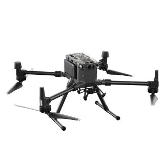
Figure 1. WRMD inventory of UAVs consists of the (a) DJI Phantom 3 Professional aircraft and the (b) DJI Matrice 300 RTK aircraft.
The DJI Phantom 3 Professional is a relatively small, entry level type UAV. Its primary function is to collect aerial imagery and 4K video using an integrated camera. It is an older model UAV that is currently no longer supported by the manufacturer. It was purchased by the WRMD in 2015 and has been used to conduct aerial surveys within the Avalon Wilderness Reserve, inspections of dam and flow control structures, as well as used to acquire images and video for training and program exposure material.
Due to its inability to meet safety requirements established by Transport Canada, the DJI Phantom 3 Professional UAV is limited to Basic Operations, which means flying is restricted to:
- less than 122 m above ground level;
- more than 30 m horizontal distance from bystanders;
- more than 5.556 km from a certified aerodrome; and
- more than 1.852 km from a certified heliport.
The DJI Matrice 300 RTK UAV is a newer, larger, more robust, safer to use and more versatile UAV. It was purchased in January 2021 to enable the WRMD to conduct advanced operations, where flights would not be limited by the aforementioned restrictions. This aircraft can fly longer, further, and in more adverse weather conditions than the DJI Phantom 3 Professional. It has direction and position sensors on all its sides to facilitate obstacle avoidance and to enhance in-flight safety and stability. Multiple payload configurations are possible with this UAV, allowing up to three payloads to be mounted simultaneously, including such payloads as LiDAR, multispectral imaging cameras (visible, near- and thermal-infrared), laser range finder, water grab sampler, air monitoring sensor, etc. The aircraft also has a built-in satellite navigation receiver that can be used in concert with the payload sensors to produce products with survey grade location accuracy. To date, this UAV has been used to conduct dam inspections, Blue-Green Algae (BGA) bloom extent mapping, and capture video for training material. Its enhanced capacity to handle wind and rain conditions has vastly improved the ability of WRMD to capture footage in adverse weather conditions.
3. BENEFITS OF UAV
UAV technology can greatly benefit environmental management operations for the collection of spatial data on a local and regional scale. Compared to alternative ways of collecting spatial data, using manned aircraft or satellites, UAVs are:
- a cost effective means of collecting high-quality data with survey precision;
- not constrained by third-party relations (e.g., contracting, scheduling, purchasing, etc.) when deployed by in-house staff;
- easily deployed for quick response to emerging issues (e.g., flood or pollution events);
- highly maneuverable for acquiring data in difficult-to-access areas;
- flown at lower attitudes to avoid cloud cover effects; and
- a secure means of collecting data, especially when the capacity to collect and process the data can be done in-house.
4. UAV APPLICATIONS IN ENVIRONMENTAL MONITORING
The following list outlines some current and potential UAV applications for environmental monitoring, with a focus on water resources management:
- BGA bloom extent mapping;
- River ice mapping and product confirmation (e.g., ice front, leads);
- Flood event emergency response (e.g., map extent and damage to properties);
- Pollution event emergency response (e.g., map extent and investigate cause);
- Turbidity mapping resulting from natural or manmade disturbances;
- Sewage and industrial outfall detection;
- Dam inspection including condition, leakage and movement;
- Create or update digital elevation models used for flood risk mapping;
- Air pollution monitoring;
- Videos for promotional, explanatory, or training material;
- Water grab sample collection;
- Streamflow monitoring using particle tracking velocimetry methods;
- Protected watershed and public water supply surveillance and change detection;
- Wetland mapping, especially near urban development; and
- Water distribution systems leakage detection.
5. PILOTS
The WRMD currently has three certified pilots (Keith Abbott, Leona Hyde, and Randy Parsons) that are capable of carrying out basic and advanced flight operations. All pilots have completed UAV Ground School training available through PSAccess. Several additional staff have experience aiding with flight operations by serving as visual observers, assisting pilots in conducting safe flights in areas where hazards such as power lines, bystanders, wildlife, and other obstacles exist.
6. INSURANCE
A Remotely Piloted Aircraft System Liability Insurance has been arranged by Insurance Officers with the Department of Transportation and Infrastructure. Insurance is renewed annually.
7. PATH FORWARD
- Initiate or continue collaboration with partner organizations interested in UAV operations, such as the Geological Survey of Newfoundland and Labrador and Environment and Climate Change Canada.
- Develop and document standard operating procedures for creating high-quality UAV products (e.g., 3D surface and terrain models).
- Integrate Post Processed Kinematic (PPK) corrections into production workflow, to create spatial datasets with precise location information.
- Plan for new sensor integration, such as LiDAR and multispectral cameras.
- Increase the functionality of the Matrice 300 RTK UAV system, such as adding batteries to increase flight time and adding a second controller to improve flight and payload operation and to maximize flight range.
- Maintain pilot certification through Transport Canada’s recency requirements program.