


One of the last wilderness rivers-and one of the best white-water canoeing rivers-on the Island of Newfoundland, the Main River may be memorable for the thrilling ride it gives, but it offers much more than rapids and paddling excitement. Virgin boreal forest, placid lakes, the slow waters and lush surroundings of the Big Steady-Atlantic salmon and abundant wildlife – habitat for the endangered Newfoundland marten – spectacular viewscapes and a true wilderness passage-all these are part of the Main River experience.
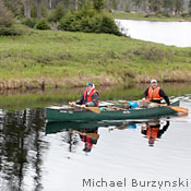
The Main River is renowned as a wilderness adventure waterway for experienced canoeists. Highly suitable for white-water canoeing, kayaking, and rafting – not to mention angling and bird- and wildlife watching – it has its headwaters in the Long Range Mountains, passes through the tranquility of the Big Steady, and runs its last 23 km in a white-water dash to the sea.
The Main is at the base of the Great Northern Peninsula. From its headwaters, 675 metres above sea level, you can see the barrens and tundra of the Long Range Mountains behind Gros Morne National Park. The river heads away from these through old-growth forests, flowing 57 km in a southeastern direction to the salt waters of White Bay, emerging near the community of Sop’s Arm. For a description of the five sections (or “Units”) of the Main, see Canoeing.
One of the jewels of the Main River experience is “the Big Steady,” about 17 km from the headwaters, where the river snakes and slows, flowing through flat grassland. Islands on the Big Steady are open and park-like; two-century-old birch and spruce – ancient enough to have trunks that reach 75 cm in width – flank the area’s streams and pools.
The Main River passes through terrain that is home to 70 species of bird, caribou from the Northern Peninsula herd, many kinds of waterfowl, as well as moose, black bear, and the endangered Newfoundland marten. Atlantic salmon and brook trout swim in its waters. Its unique ecosystems belong to two of the province’s ecoregions – the Long Range Barrens (Northern Long Range subregion) (783 KB) and the Northern Peninsula Forest (Eastern Long Range subregion) (887 KB). Many of the plants that grow there are at the extent of their northern or southern ranges.
Though it’s known for its summer water activities, the area is also an excellent venue for wilderness recreation in winter. Appropriate snow conditions persist for much longer than elsewhere on the Island, often from January right through to May.
Three archaeological sites have been identified along the river. Evidence of early Inuit habitation dates to about 2,100 years ago. Along the north side of the river, just west of Sop’s Arm, remains of nomadic Beothuk culture have been found. In more recent centuries, the French and the English had fishing enterprises in the area.
First nominated as a Canadian Heritage River in 1991, the Main received its designation in February, 2001. It is managed by the Policy, Planning and Natural Areas Division of the Department of Environment and Climate Change and comprises the river corridor. The Main River is also protected as a 152-km2 Waterway Provincial Park and an additional 49km2 Special Management Area. The Waterway Provincial Park is managed by the Parks Division of the Department of Tourism, Culture, Arts and Recreation.
How to get there
The Main River is located at the southern end of Newfoundland’s Great Northern Peninsula. From its headwaters in the Long Range Mountains, it flows southeastward to Sop’s Arm, in White Bay.
The Main is a wilderness river-no highways wind along it, though there is a paved road leading to the mouth of the river in Sop’s Arm. An unpaved woods road from the community provides access 13 km upriver, to the Kruger bridge. A few
points are accessible by float plane or helicopter, and by rough hiking tracks. ATV use is not allowed in the Heritage River area except on the woods road leading from Sop’s Arm. Snowmobiles can be used during winter months. *
The closest regional airport is located in Deer Lake (YDF) approx. 1hr drive from Sop’s Arm.
Reaching the rough portage trails that lead to the Four Ponds Unit (near the river’s headwaters) begins by taking a wood-harvesting road from Route 420, which leaves Route 420 about 22 km from the Trans-Canada Highway/Route 420 junction. (Note: wood-harvesting roads are best suited for four-wheel drive vehicles with high clearance only.
View a Map of the Main River (790 KB)
Access to the Four Ponds Unit is by float plane, helicopter, or by a five-hour walk on a rough portage trail from the nearest forest access road (refer to map).
Hikers and anglers can get to the Big Steady Unit via a rough hiking trail that begins where the wood-harvesting road leading upriver from Sop’s Arm ends (refer to map). The hike from there to the Big Steady takes about 2.5 to 3 hours.
Conditions will be wet; sturdy, waterproof footwear is a must. Vehicles can be left where the hiking trail begins, on the side of the woods road.
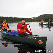
Canoers, kayakers, and white-water rafting enthusiasts gain access to the Deep Valley Unit from the same, rough 17-km woods road that leads to the Kruger Bridge from Sop’s Arm. In 2004, a small gravel parking lot and two outhouses were constructed adjacent to the bridge to accommodate river users. This area is for day use only, not camping.
Further details about access are available from individual local outfitters, and from the Natural Areas staff.
Fees & Schedules
No fees are charged to visit the Main River Canadian Heritage River.
Outfitters, of course, do charge for their commercial services: guiding, float planes, staying at a camp, etc. Fees vary.
Angling and hunting dates vary by species; consult the annual Hunting and Fishing Guide produced by the Department of Fisheries, Forestry and Agriculture for details.
Winter recreational activities occur from January to May, depending on snow and ice conditions.
Rules & Regulations
To maintain its Canadian Heritage River status, the Main River must keep its pristine wilderness quality. This means that all visitors to the Main must “leave only footprints.” General guidelines for low-impact visiting or camping are listed below.
Generally, the following activities are prohibited along the river or inside the Heritage River boundary.
- disturbing or destroying habitat
- mining (including exploration), hydro development, and agriculture
- driving off-road vehicles including all-terrain vehicles (ATVs), except on existing roads
In addition, visitors should follow these guidelines:
- pack out everything you bring in, including cans, glass, and other refuse
- observe fire guidelines-during some seasons, open fires may be prohibited. Contact your local office of the Department of Natural Resources to determine if open fires are permitted. Completely extinguish fires before leaving.
- Note that aircraft must fly above 300 metres, except during take-off and landing, while in the river system area. Exceptions are allowed during poor weather conditions and emergencies.
Low-Impact Camping Guidelines
- choose reusable containers and utensils
- use camp stoves instead of campfires made from wood you gather
- if you make a campfire, use only small, downed dry dead wood
- burn only paper waste-plastic, foil, and food do not burn completely use only no-phosphate soaps and detergents to wash dishes, clothes, and yourself-and do it in a basin away from the river. Phosphate detergents are toxic for small fish.
- create your own toilet pit at least 300 feet from the water
- dump waste water into toilet pit
- avoid trenching-choose higher ground for wet weather tenting
- sleep on a pad or air mattress, not gathered leaves or evergreen needles
- wear shoes and boots that have low-profile treads (so disturb less soil)
- buy food in bulk to avoid excessive packaging
- bring food in reusable containers or re-sealable plastic bags
- rinse and flatten cans, and take them home to recycle
- keep animals out of your trash-hang the food bag high and away from the campsite
- carry out all of your garbage
Official Regulations
- Provincial Parks Act
- Provincial Parks Regulations
- Main River Waterway Provincial Park Order
- Lands Act
- Main River Special Management Area Regulation
Other Resources
The following resources can help you learn more about Main River Canadian Heritage River.
- Northern Peninsula Forest ecoregion-Eastern Long Range subregion 4D(888 KB)
- Long Range Barrens ecoregion-Northern Long Range subregion 8C (783 KB)
- Island of Newfoundland Ecoregions and Subregions Map (757 KB)
- Main River Canadian Heritage River Management Plan(1.9 MB)
- Main River Canadian Heritage River 10- year Monitoring Report (2011)
For more resources on Newfoundland and Labrador’s protected areas, please visit Publications and Maps.
Adobe® Acrobat® Reader software can be used for viewing PDF documents. Download Acrobat® Reader for free.