Background
Snowfall accounts for a significant percentage of annual precipitation in virtually all regions of the province. During the spring months melting snow is a major supplier of water to reservoirs, lakes, and rivers and through infiltration, soil moisture and groundwater. Rain-on-snow events, during the snowmelt period, greatly increases the risk of flooding to people and communities located along the province’s lakes and rivers.
Snow monitoring provides essential information for flood forecasting, hydropower generation, wildlife studies, drinking water reservoir operation, and for climate change adaptation in the province. The Water Resources Management Division (WRMD) provides flood forecasting services, in which snow monitoring has been integrated, for the communities of Badger, in the Exploits River Basin, and Deer Lake and Steady Brook, in the Humber River Basin.
WRMD undertakes snow monitoring for the Exploits River Basin and the (Upper and Lower) Humber River Basin (identified in the below map). Snow monitoring involves determining the extent of snow cover (SE) and its snow water equivalent (SWE). SWE is a measurement of both the depth of snow and its density. It represents the depth of water that would result if the entire snow cover melted at once.
To calculate SE and SWE values, WRMD uses a combination of satellite-based snow products, snow stations, and in the field snow surveys.
Snow Monitoring Products
In 2008, WRMD developed snow products, based on Moderate Resolution Imaging Spectroradiometer (MODIS) satellite imagery provided for free by NASA , which indicates the SE in the Humber River Basin. The products were used to support the Humber River flood forecasting service and allowed the WRMD to monitor the changing SE during the snowmelt period. When the SE product indicates there is no snow left in the basin the threat of flooding from sudden snowmelt has passed.
In 2009, WRMD in collaboration with the European Space Agency (ESA) joined the international GlobSnow project. WRMD was the only provincial partner in the project. One of the objectives of the project was to advance the use of remote sensing in snow monitoring and an outcome of the project was the development of SE and SWE snow products.
Snow products for the Exploits and Humber Basins can be seen at the page below:
Snow Products for Exploits and Humber
The two research papers below describe the process used to create the SE and SWE products:
- Investigation of MODIS Snow Mapping In a Boreal Forest Watershed (725 KB)
- Adapting Remotely Sensed Snow Data for Daily Flow Forecasting on the Humber River, Newfoundland and Labrador (4.7 MB)
Verifying the Snow Monitoring Products
Annual Field Survey
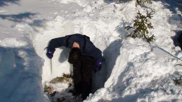
To help verify the satellite-based snow products, an annual field snow survey is undertaken by WRMD. The survey is a critical component of the snow monitoring service and provides highly- accurate SE and SWE values. These field values are used to calibrate and verify SE and SWE values obtained from the satellite-based snow products and the snow stations. Shown in the figure below is WRMD staff, during the snow survey, measuring snow depth.
Automated Stations
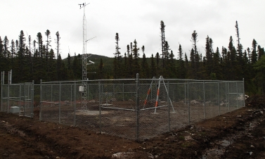
In 2010, WRMD installed the province’s first automated snow station at Sandy Lake near Birchy Narrows (Camp 55) in the Humber River Basin (shown in the image below). The station is equipped with the GMON3 snow water equivalency sensor. The GMON3 is new technology which calculates SWE values by monitoring changes in the natural background radiation of the soil as snow accumulates or melts. Additionally, the Humber Snow Station has a snow depth sensor and is also a complete weather station with sensors to measure parameters such as temperature, rainfall, and wind speed.
Sandy Lake near Birchy Narrows (Camp 55)
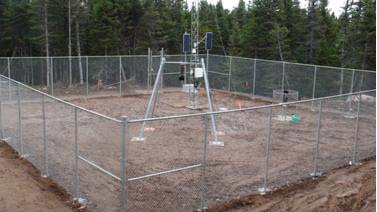
In 2015, a second station was added in the Upper Humber River Basin
Upper Humber River Above Black Brook – Weather Station