

- Human Footprint Analysis for Newfoundland and Labrador (2013)
- Development Considerations Maps for the Island of Newfoundland (2020)
- Protected Areas Strategy
Human Footprint Analysis
 The dominant threat to biodiversity is habitat loss, degradation and fragmentation, driven by change in land use as intact natural landscapes are converted to industrial activities (Newbold et al., 2015). This change in land use is often called the human footprint. A human footprint analysis distinguishes areas that are wilderness from areas that have been altered by habitat loss (e.g., logging, mining, quarries, conversion to agriculture) or habitat fragmentation (building roads, power lines, or mineral/petroleum exploration that involves cutting seismic lines). Areas with a low human footprint are often good candidates for a protected natural area.
A Human Footprint Analysis was completed for Newfoundland and Labrador in 2013.
Development Considerations for the Island of Newfoundland
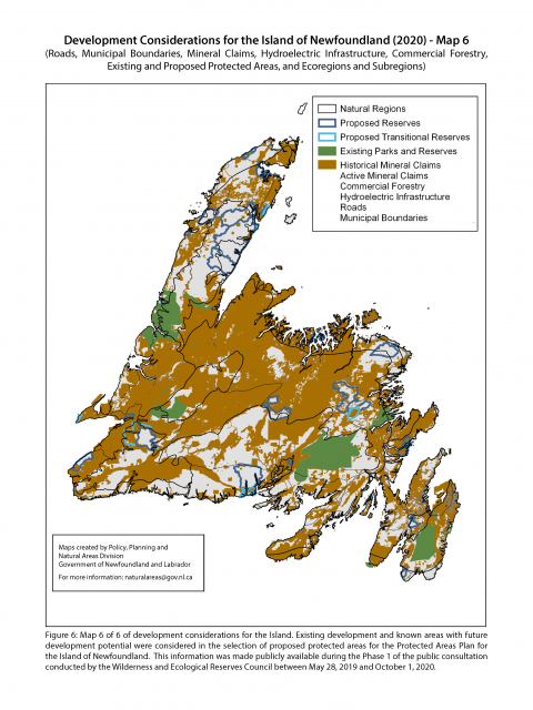 In 2020, mapping was developed by Policy, Planning and Natural Areas Division, Department of Environment and Climate Change, to illustrate the development considerations for the selection of areas proposed in the Protected Areas Plan.
This map series includes municipal boundaries, the existing road network, all active and historical mining claims, commercial forestry, and hydroelectric infrastructure. The methodology for choosing proposed reserves for the Protected Areas Plan included prioritizing intact areas and avoiding areas of interest for forestry, agriculture, minerals, petroleum industries and other developments. The map series uses newer data and different methodology compared to the 2013 Human Footprint Analysis.